Submitted URL: http://alstate.com/
Effective URL: https://alstate.com/
Submission: On December 06 via api from US — Scanned from US

Summary

This website contacted 10 IPs in 1 countries across 5 domains to perform 408 HTTP transactions. The main IP is 135.148.66.111, located in United States and belongs to OVH, FR. The main domain is alstate.com.
TLS certificate: Issued by cPanel, Inc. Certification Authority on December 3rd 2022. Valid for: 3 months.
This is the only time alstate.com was scanned on urlscan.io!

urlscan.io Verdict: No classification

Domain & IP information

IP Address AS Autonomous System
1 6 135.148.66.111 16276 (OVH)
41 216.226.185.187 11109 (SAISD-1)
1 143 13.249.190.111 16509 (AMAZON-02)
61 23.73.224.166 16625 (AKAMAI-AS)
18 54.192.51.49 16509 (AMAZON-02)
94 18.234.22.28 14618 (AMAZON-AES)
41 65.8.20.91 16509 (AMAZON-02)
1 2600:9000:215... 16509 (AMAZON-02)
1 2600:9000:20e... 16509 (AMAZON-02)
408 10
Apex Domain
Subdomains
Transfer
297 arcgis.com
js.arcgis.com — Cisco Umbrella Rank: 9105
static.arcgis.com — Cisco Umbrella Rank: 21526
www.arcgis.com — Cisco Umbrella Rank: 17897
cdn.arcgis.com — Cisco Umbrella Rank: 30140
basemaps.arcgis.com — Cisco Umbrella Rank: 26067
fly.maptiles.arcgis.com — Cisco Umbrella Rank: 299985
4 MB
61 arcgisonline.com
services.arcgisonline.com — Cisco Umbrella Rank: 15326
server.arcgisonline.com — Cisco Umbrella Rank: 15471
646 KB
41 alabama.gov
conservationgis.alabama.gov
105 KB
6 alstate.com
alstate.com
42 KB
1 nationalmap.gov
basemap.nationalmap.gov — Cisco Umbrella Rank: 135141
5 KB
408 5
Domain Requested by
143 js.arcgis.com 1 redirects conservationgis.alabama.gov
js.arcgis.com
94 www.arcgis.com js.arcgis.com
41 cdn.arcgis.com js.arcgis.com
41 conservationgis.alabama.gov alstate.com
conservationgis.alabama.gov
js.arcgis.com
34 services.arcgisonline.com js.arcgis.com
conservationgis.alabama.gov
27 server.arcgisonline.com conservationgis.alabama.gov
17 basemaps.arcgis.com js.arcgis.com
6 alstate.com 1 redirects alstate.com
1 fly.maptiles.arcgis.com js.arcgis.com
1 basemap.nationalmap.gov js.arcgis.com
1 static.arcgis.com js.arcgis.com
408 11

This site contains links to these domains. Also see Links.

Domain
www.alapark.com
conservationgis.alabama.gov
Subject Issuer Validity Valid
alstate.com
cPanel, Inc. Certification Authority
2022-12-03 -
2023-03-03
3 months crt.sh
conservationgis.alabama.gov
GlobalSign RSA OV SSL CA 2018
2022-10-13 -
2023-11-14
a year crt.sh
*.arcgis.com
Amazon
2022-08-22 -
2023-09-20
a year crt.sh
*.arcgisonline.com
DigiCert TLS RSA SHA256 2020 CA1
2022-10-24 -
2023-10-26
a year crt.sh
*.nationalmap.gov
DigiCert TLS RSA SHA256 2020 CA1
2022-07-13 -
2023-07-16
a year crt.sh
*.maptiles.arcgis.com
Amazon
2022-06-28 -
2023-07-27
a year crt.sh

This page contains 2 frames:

Primary Page: https://alstate.com/
Frame ID: B810A41B0111CEEA1858E4795D2769E8
Requests: 5 HTTP requests in this frame

Frame: https://conservationgis.alabama.gov/alapark/
Frame ID: EFF63DD751D06C350471D39734B5D91A
Requests: 405 HTTP requests in this frame

Screenshot

Page Title

ALstate.com | AL-state.com | AL | ALABAMA | AL - Alabama State Parks and Recreational Activities

Page URL History Show full URLs

  1. http://alstate.com/ HTTP 301
    https://alstate.com/ Page URL

Detected technologies

Overall confidence: 100%
Detected patterns
  • js\.arcgis\.com
  • basemaps\.arcgis\.com

Overall confidence: 100%
Detected patterns
  • ([\d.]+)/dojo/dojo(?:\.xd)?\.js

Overall confidence: 100%
Detected patterns
  • moment(?:\.min)?\.js

Overall confidence: 100%
Detected patterns
  • math(?:\.min)?\.js

Page Statistics

408
Requests

99 %
HTTPS

22 %
IPv6

5
Domains

11
Subdomains

10
IPs

1
Countries

5250 kB
Transfer

18749 kB
Size

0
Cookies

Page URL History

This captures the URL locations of the websites, including HTTP redirects and client-side redirects via JavaScript or Meta fields.

  1. http://alstate.com/ HTTP 301
    https://alstate.com/ Page URL

Redirected requests

There were HTTP redirect chains for the following requests:

Request Chain 6
  • https://js.arcgis.com/4.12/ HTTP 301
  • https://js.arcgis.com/4.12/dojo/dojo.js

408 HTTP transactions

Resource
Path
Size
x-fer
Type
MIME-Type
Primary Request /
alstate.com/
Redirect Chain
  • http://alstate.com/
  • https://alstate.com/
2 KB
2 KB
Document
General
Full URL
https://alstate.com/
Protocol
HTTP/1.1
Security
TLS 1.3, , AES_128_GCM
Server
135.148.66.111 , United States, ASN16276 (OVH, FR),
Reverse DNS
cpadv111.bmwebhost.com
Software
Apache /
Resource Hash
d19701e0bc67ed336944bf50de156b3cfa33f561628950a8ccb1ad18cd124eb0

Request headers

Upgrade-Insecure-Requests
1
User-Agent
Mozilla/5.0 (Windows NT 10.0; Win64; x64) AppleWebKit/537.36 (KHTML, like Gecko) Chrome/108.0.5359.94 Safari/537.36
accept-language
en-US,en;q=0.9

Response headers

Accept-Ranges
bytes
Connection
Keep-Alive
Content-Length
1766
Content-Type
text/html
Date
Tue, 06 Dec 2022 09:31:04 GMT
Keep-Alive
timeout=5, max=100
Last-Modified
Tue, 12 Apr 2022 12:54:49 GMT
Server
Apache

Redirect headers

Connection
Keep-Alive
Content-Length
228
Content-Type
text/html; charset=iso-8859-1
Date
Tue, 06 Dec 2022 09:31:04 GMT
Keep-Alive
timeout=5, max=100
Location
https://alstate.com/
Server
Apache
WelcomeTheStartOfSummer.gif
alstate.com/
1 KB
1 KB
Image
General
Full URL
https://alstate.com/WelcomeTheStartOfSummer.gif
Requested by
Host: alstate.com
URL: https://alstate.com/
Protocol
HTTP/1.1
Security
TLS 1.3, , AES_128_GCM
Server
135.148.66.111 , United States, ASN16276 (OVH, FR),
Reverse DNS
cpadv111.bmwebhost.com
Software
Apache /
Resource Hash
1b6b951f839497e98ac1bcc874a2d2761d639a5deb782c202cf26998256a3dd1

Request headers

accept-language
en-US,en;q=0.9
Referer
https://alstate.com/
User-Agent
Mozilla/5.0 (Windows NT 10.0; Win64; x64) AppleWebKit/537.36 (KHTML, like Gecko) Chrome/108.0.5359.94 Safari/537.36

Response headers

Date
Tue, 06 Dec 2022 09:31:04 GMT
Last-Modified
Tue, 31 Mar 2015 10:58:48 GMT
Server
Apache
Content-Type
image/gif
Connection
Keep-Alive
Accept-Ranges
bytes
Keep-Alive
timeout=5, max=99
Content-Length
1258
ALStateFlagWave%20.gif
alstate.com/
27 KB
27 KB
Image
General
Full URL
https://alstate.com/ALStateFlagWave%20.gif
Requested by
Host: alstate.com
URL: https://alstate.com/
Protocol
HTTP/1.1
Security
TLS 1.3, , AES_128_GCM
Server
135.148.66.111 , United States, ASN16276 (OVH, FR),
Reverse DNS
cpadv111.bmwebhost.com
Software
Apache /
Resource Hash
5e3aa05fe912bef87d88200e3545e4bbfdb314938f66a4c28bbacdc0e2d0f416

Request headers

accept-language
en-US,en;q=0.9
Referer
https://alstate.com/
User-Agent
Mozilla/5.0 (Windows NT 10.0; Win64; x64) AppleWebKit/537.36 (KHTML, like Gecko) Chrome/108.0.5359.94 Safari/537.36

Response headers

Date
Tue, 06 Dec 2022 09:31:04 GMT
Last-Modified
Wed, 02 Jun 2010 12:13:26 GMT
Server
Apache
Content-Type
image/gif
Connection
Keep-Alive
Accept-Ranges
bytes
Keep-Alive
timeout=5, max=98
Content-Length
27301
ALstate-comBanner2.gif
alstate.com/
2 KB
2 KB
Image
General
Full URL
https://alstate.com/ALstate-comBanner2.gif
Requested by
Host: alstate.com
URL: https://alstate.com/
Protocol
HTTP/1.1
Security
TLS 1.3, , AES_128_GCM
Server
135.148.66.111 , United States, ASN16276 (OVH, FR),
Reverse DNS
cpadv111.bmwebhost.com
Software
Apache /
Resource Hash
58a9db271671867fb3a7c5781d9c5b848cfa65c21069f7fe8a50b75c51f1c089

Request headers

accept-language
en-US,en;q=0.9
Referer
https://alstate.com/
User-Agent
Mozilla/5.0 (Windows NT 10.0; Win64; x64) AppleWebKit/537.36 (KHTML, like Gecko) Chrome/108.0.5359.94 Safari/537.36

Response headers

Date
Tue, 06 Dec 2022 09:31:04 GMT
Last-Modified
Wed, 15 Sep 2010 10:47:30 GMT
Server
Apache
Content-Type
image/gif
Connection
Keep-Alive
Accept-Ranges
bytes
Keep-Alive
timeout=5, max=100
Content-Length
1907
comodo_secure_seal_100x85_transp.png
alstate.com/
9 KB
9 KB
Image
General
Full URL
https://alstate.com/comodo_secure_seal_100x85_transp.png
Requested by
Host: alstate.com
URL: https://alstate.com/
Protocol
HTTP/1.1
Security
TLS 1.3, , AES_128_GCM
Server
135.148.66.111 , United States, ASN16276 (OVH, FR),
Reverse DNS
cpadv111.bmwebhost.com
Software
Apache /
Resource Hash
133f96ceac619d2317cd9e4e3e9f40f30929fb612c170231cb400953d3546602

Request headers

accept-language
en-US,en;q=0.9
Referer
https://alstate.com/
User-Agent
Mozilla/5.0 (Windows NT 10.0; Win64; x64) AppleWebKit/537.36 (KHTML, like Gecko) Chrome/108.0.5359.94 Safari/537.36

Response headers

Date
Tue, 06 Dec 2022 09:31:04 GMT
Last-Modified
Tue, 12 Apr 2022 12:52:37 GMT
Server
Apache
Content-Type
image/png
Connection
Keep-Alive
Accept-Ranges
bytes
Keep-Alive
timeout=5, max=97
Content-Length
9277
/
conservationgis.alabama.gov/alapark/ Frame EFF6
12 KB
12 KB
Document
General
Full URL
https://conservationgis.alabama.gov/alapark/
Requested by
Host: alstate.com
URL: https://alstate.com/
Protocol
H2
Security
TLS 1.2, ECDHE_RSA, AES_256_GCM
Server
216.226.185.187 Montgomery, United States, ASN11109 (SAISD-1, US),
Reverse DNS
conservationgis.alabama.gov
Software
Microsoft-IIS/10.0 / ASP.NET
Resource Hash
8f375be124220245f78597c299f94b99bf7148387bfa079204a77386701f39f2

Request headers

Referer
https://alstate.com/
Upgrade-Insecure-Requests
1
User-Agent
Mozilla/5.0 (Windows NT 10.0; Win64; x64) AppleWebKit/537.36 (KHTML, like Gecko) Chrome/108.0.5359.94 Safari/537.36
accept-language
en-US,en;q=0.9

Response headers

accept-ranges
bytes
content-length
12254
content-type
text/html
date
Tue, 06 Dec 2022 09:31:05 GMT
etag
"1b73b1398afd51:0"
last-modified
Tue, 10 Dec 2019 20:26:16 GMT
server
Microsoft-IIS/10.0
x-powered-by
ASP.NET
main.css
js.arcgis.com/4.12/esri/themes/light/ Frame EFF6
210 KB
27 KB
Stylesheet
General
Full URL
https://js.arcgis.com/4.12/esri/themes/light/main.css
Requested by
Host: conservationgis.alabama.gov
URL: https://conservationgis.alabama.gov/alapark/
Protocol
H2
Security
TLS 1.3, , AES_128_GCM
Server
13.249.190.111 , United States, ASN16509 (AMAZON-02, US),
Reverse DNS
server-13-249-190-111.bos50.r.cloudfront.net
Software
AmazonS3 /
Resource Hash
f9e2c56a8155ada4c9e4b9bf2eb33a1d53ec5947d07f04576d0815e50dd828ff
Security Headers
Name Value
Content-Security-Policy upgrade-insecure-requests
Strict-Transport-Security max-age=6307200

Request headers

accept-language
en-US,en;q=0.9
Referer
https://conservationgis.alabama.gov/
User-Agent
Mozilla/5.0 (Windows NT 10.0; Win64; x64) AppleWebKit/537.36 (KHTML, like Gecko) Chrome/108.0.5359.94 Safari/537.36

Response headers

date
Tue, 06 Dec 2022 09:31:06 GMT
content-encoding
br
via
1.1 7892446663b4185f4fe79acff7f3a46e.cloudfront.net (CloudFront)
x-amz-version-id
QEjTs8GPCE41LBrvJzNRwW7WJ5_r1G1j
content-security-policy
upgrade-insecure-requests
x-amz-cf-pop
BOS50-C2
strict-transport-security
max-age=6307200
x-cache
Miss from cloudfront
content-length
26874
last-modified
Wed, 21 Oct 2020 16:21:02 GMT
server
AmazonS3
etag
"75a3f72eec6516fd146a6fff6f241311"
access-control-max-age
3000
access-control-allow-methods
HEAD, GET
content-type
text/css
access-control-allow-origin
*
cache-control
max-age=86400
x-amz-cf-id
nhMd4QwWmLiTXHmx3-EOQlYD0F08oU4rPCx-VGRuA8ZETrtfdUjZmA==
dojo.js
js.arcgis.com/4.12/dojo/ Frame EFF6
Redirect Chain
  • https://js.arcgis.com/4.12/
  • https://js.arcgis.com/4.12/dojo/dojo.js
989 KB
199 KB
Script
General
Full URL
https://js.arcgis.com/4.12/dojo/dojo.js
Requested by
Host: conservationgis.alabama.gov
URL: https://conservationgis.alabama.gov/alapark/
Protocol
H2
Server
13.249.190.111 , United States, ASN16509 (AMAZON-02, US),
Reverse DNS
server-13-249-190-111.bos50.r.cloudfront.net
Software
AmazonS3 /
Resource Hash
2bbc7ac509ffa9851668eeaccd782123e8e74a9391266f7a0a1f3a706506e97d
Security Headers
Name Value
Content-Security-Policy upgrade-insecure-requests
Strict-Transport-Security max-age=6307200

Request headers

accept-language
en-US,en;q=0.9
Referer
https://conservationgis.alabama.gov/
User-Agent
Mozilla/5.0 (Windows NT 10.0; Win64; x64) AppleWebKit/537.36 (KHTML, like Gecko) Chrome/108.0.5359.94 Safari/537.36

Response headers

x-amz-version-id
bOan.2KOz7ZHBRK1aZGCgIK5c9C2HuF8
content-encoding
br
via
1.1 7892446663b4185f4fe79acff7f3a46e.cloudfront.net (CloudFront)
content-security-policy
upgrade-insecure-requests
strict-transport-security
max-age=6307200
x-amz-cf-pop
BOS50-C2
age
32507
date
Tue, 06 Dec 2022 00:29:19 GMT
x-cache
Hit from cloudfront
content-length
202990
last-modified
Wed, 21 Oct 2020 16:20:09 GMT
server
AmazonS3
etag
"5b535922dc3fc205afa25edc0dbb03c0"
access-control-max-age
3000
access-control-allow-methods
HEAD, GET
content-type
application/javascript
access-control-allow-origin
*
cache-control
max-age=86400
x-amz-cf-id
GZV5WBj_ebuAUrG7v7xEsrXrkyo5HDy-RBFf7qbN9w4RkdxUdRmrkw==

Redirect headers

date
Tue, 06 Dec 2022 03:49:39 GMT
via
1.1 7892446663b4185f4fe79acff7f3a46e.cloudfront.net (CloudFront)
server
CloudFront
x-amz-cf-pop
BOS50-C2
age
20486
access-control-max-age
3000
access-control-allow-methods
HEAD, GET
x-cache
Hit from cloudfront
location
/4.12/dojo/dojo.js
access-control-allow-origin
*
content-length
0
x-amz-cf-id
6ox9OSRXnZMABrYEsUJTczIdidd6Be-uQf-BPun8zTc2sqS_H9_rlg==
StateParks.png
conservationgis.alabama.gov/Documents/ Frame EFF6
5 KB
5 KB
Image
General
Full URL
https://conservationgis.alabama.gov/Documents/StateParks.png
Requested by
Host: conservationgis.alabama.gov
URL: https://conservationgis.alabama.gov/alapark/
Protocol
H2
Security
TLS 1.2, ECDHE_RSA, AES_256_GCM
Server
216.226.185.187 Montgomery, United States, ASN11109 (SAISD-1, US),
Reverse DNS
conservationgis.alabama.gov
Software
Microsoft-IIS/10.0 / ASP.NET
Resource Hash
a5bec5c1b3d3cd31eac132364a7a4704d299dcf57d378a6757b1c4a855ec21e7

Request headers

accept-language
en-US,en;q=0.9
Referer
https://conservationgis.alabama.gov/alapark/
User-Agent
Mozilla/5.0 (Windows NT 10.0; Win64; x64) AppleWebKit/537.36 (KHTML, like Gecko) Chrome/108.0.5359.94 Safari/537.36

Response headers

date
Tue, 06 Dec 2022 09:31:05 GMT
last-modified
Mon, 22 Jul 2019 18:01:07 GMT
server
Microsoft-IIS/10.0
etag
"fe517e6fb740d51:0"
x-powered-by
ASP.NET
content-type
image/png
accept-ranges
bytes
content-length
4678
dojo_en-us.js
js.arcgis.com/4.12/dojo/nls/ Frame EFF6
781 B
893 B
Script
General
Full URL
https://js.arcgis.com/4.12/dojo/nls/dojo_en-us.js
Requested by
Host: js.arcgis.com
URL: https://js.arcgis.com/4.12/
Protocol
H2
Security
TLS 1.3, , AES_128_GCM
Server
13.249.190.111 , United States, ASN16509 (AMAZON-02, US),
Reverse DNS
server-13-249-190-111.bos50.r.cloudfront.net
Software
AmazonS3 /
Resource Hash
16bdb00b7ccf4fb39277bc8f7640aad0860fae1fa9e50b3c45af812a112ce5a0
Security Headers
Name Value
Content-Security-Policy upgrade-insecure-requests
Strict-Transport-Security max-age=6307200

Request headers

accept-language
en-US,en;q=0.9
Referer
https://conservationgis.alabama.gov/
User-Agent
Mozilla/5.0 (Windows NT 10.0; Win64; x64) AppleWebKit/537.36 (KHTML, like Gecko) Chrome/108.0.5359.94 Safari/537.36

Response headers

x-amz-version-id
0oURe_rtx2giwIlj671aZcw7eI.idWoV
content-encoding
br
via
1.1 7892446663b4185f4fe79acff7f3a46e.cloudfront.net (CloudFront)
content-security-policy
upgrade-insecure-requests
strict-transport-security
max-age=6307200
x-amz-cf-pop
BOS50-C2
age
9383
date
Tue, 06 Dec 2022 06:54:43 GMT
x-cache
Hit from cloudfront
content-length
356
last-modified
Wed, 21 Oct 2020 16:20:09 GMT
server
AmazonS3
etag
"320796b3cd6657e9884269952ebac65a"
access-control-max-age
3000
access-control-allow-methods
HEAD, GET
content-type
application/javascript
access-control-allow-origin
*
cache-control
max-age=86400
x-amz-cf-id
1SYMLPuWpSTpbBqmOaMsahhJkNKkwdnOAa8-lw5jwEivh36acesHlA==
MapView.js
js.arcgis.com/4.12/esri/views/ Frame EFF6
298 KB
64 KB
Script
General
Full URL
https://js.arcgis.com/4.12/esri/views/MapView.js
Requested by
Host: js.arcgis.com
URL: https://js.arcgis.com/4.12/
Protocol
H2
Security
TLS 1.3, , AES_128_GCM
Server
13.249.190.111 , United States, ASN16509 (AMAZON-02, US),
Reverse DNS
server-13-249-190-111.bos50.r.cloudfront.net
Software
AmazonS3 /
Resource Hash
c58d5a3a3624f909119fd88a5dd4cd9553b408bce626b1e698eb3aac6ed818ae
Security Headers
Name Value
Content-Security-Policy upgrade-insecure-requests
Strict-Transport-Security max-age=6307200

Request headers

accept-language
en-US,en;q=0.9
Referer
https://conservationgis.alabama.gov/
User-Agent
Mozilla/5.0 (Windows NT 10.0; Win64; x64) AppleWebKit/537.36 (KHTML, like Gecko) Chrome/108.0.5359.94 Safari/537.36

Response headers

date
Tue, 06 Dec 2022 09:18:57 GMT
content-encoding
br
via
1.1 7892446663b4185f4fe79acff7f3a46e.cloudfront.net (CloudFront)
x-amz-version-id
9TdrCNG_IiEsKMW2_IAo1xBbWWDV.HrW
content-security-policy
upgrade-insecure-requests
x-amz-cf-pop
BOS50-C2
age
729
strict-transport-security
max-age=6307200
x-cache
Hit from cloudfront
content-length
64854
last-modified
Wed, 21 Oct 2020 16:21:07 GMT
server
AmazonS3
etag
"f887916916131a615d8461609c4de8a3"
access-control-max-age
3000
access-control-allow-methods
HEAD, GET
content-type
application/javascript
access-control-allow-origin
*
cache-control
max-age=86400
x-amz-cf-id
DkvSYMWqa4Qd2Cxp9KXd_8CJAjmQD80SpeUcfIbjzk-UlWRr9BxCCQ==
Expand.js
js.arcgis.com/4.12/esri/widgets/ Frame EFF6
4 KB
2 KB
Script
General
Full URL
https://js.arcgis.com/4.12/esri/widgets/Expand.js
Requested by
Host: js.arcgis.com
URL: https://js.arcgis.com/4.12/
Protocol
H2
Security
TLS 1.3, , AES_128_GCM
Server
13.249.190.111 , United States, ASN16509 (AMAZON-02, US),
Reverse DNS
server-13-249-190-111.bos50.r.cloudfront.net
Software
AmazonS3 /
Resource Hash
4003a01402eab36ab81d3b21af9b2015a29377adb4b330e1693d44e2929b61cc
Security Headers
Name Value
Content-Security-Policy upgrade-insecure-requests
Strict-Transport-Security max-age=6307200

Request headers

accept-language
en-US,en;q=0.9
Referer
https://conservationgis.alabama.gov/
User-Agent
Mozilla/5.0 (Windows NT 10.0; Win64; x64) AppleWebKit/537.36 (KHTML, like Gecko) Chrome/108.0.5359.94 Safari/537.36

Response headers

x-amz-version-id
0l6N43lpmuMMWTK.0C2y_UDZBXjN5I2p
content-encoding
br
via
1.1 7892446663b4185f4fe79acff7f3a46e.cloudfront.net (CloudFront)
content-security-policy
upgrade-insecure-requests
strict-transport-security
max-age=6307200
x-amz-cf-pop
BOS50-C2
age
51688
date
Mon, 05 Dec 2022 19:09:38 GMT
x-cache
Hit from cloudfront
content-length
1197
last-modified
Wed, 21 Oct 2020 16:21:17 GMT
server
AmazonS3
etag
"893f0fb6575bb6f2c2687318b6fb9adb"
access-control-max-age
3000
access-control-allow-methods
HEAD, GET
content-type
application/javascript
access-control-allow-origin
*
cache-control
max-age=86400
x-amz-cf-id
I0DRn0NXYx1Ihgx4JuAugmb3mVo9w-muBbdbEMaHelz9GNTA6eAWDA==
BasemapGallery.js
js.arcgis.com/4.12/esri/widgets/ Frame EFF6
3 KB
2 KB
Script
General
Full URL
https://js.arcgis.com/4.12/esri/widgets/BasemapGallery.js
Requested by
Host: js.arcgis.com
URL: https://js.arcgis.com/4.12/
Protocol
H2
Security
TLS 1.3, , AES_128_GCM
Server
13.249.190.111 , United States, ASN16509 (AMAZON-02, US),
Reverse DNS
server-13-249-190-111.bos50.r.cloudfront.net
Software
AmazonS3 /
Resource Hash
b81cf7d40c2a352e65b7dd5c01d83e9e98e3e7505fe6a31d3ba0a9a7af2626f6
Security Headers
Name Value
Content-Security-Policy upgrade-insecure-requests
Strict-Transport-Security max-age=6307200

Request headers

accept-language
en-US,en;q=0.9
Referer
https://conservationgis.alabama.gov/
User-Agent
Mozilla/5.0 (Windows NT 10.0; Win64; x64) AppleWebKit/537.36 (KHTML, like Gecko) Chrome/108.0.5359.94 Safari/537.36

Response headers

date
Mon, 05 Dec 2022 11:22:59 GMT
content-encoding
br
via
1.1 7892446663b4185f4fe79acff7f3a46e.cloudfront.net (CloudFront)
x-amz-version-id
Q.0vSTP3yAZ8W7mf3M5FcLrvpNkQRuE2
content-security-policy
upgrade-insecure-requests
x-amz-cf-pop
BOS50-C2
age
79687
strict-transport-security
max-age=6307200
x-cache
Hit from cloudfront
content-length
1149
last-modified
Wed, 21 Oct 2020 16:21:13 GMT
server
AmazonS3
etag
"d133b0061a7c4a9cee248cff01d78d49"
access-control-max-age
3000
access-control-allow-methods
HEAD, GET
content-type
application/javascript
access-control-allow-origin
*
cache-control
max-age=86400
x-amz-cf-id
WyRXzuscQVbi-XdohdiFWEsYxu5_CfYmnhCqgdv-y8WrwsMhCZvgdw==
LayerList.js
js.arcgis.com/4.12/esri/widgets/ Frame EFF6
44 KB
10 KB
Script
General
Full URL
https://js.arcgis.com/4.12/esri/widgets/LayerList.js
Requested by
Host: js.arcgis.com
URL: https://js.arcgis.com/4.12/
Protocol
H2
Security
TLS 1.3, , AES_128_GCM
Server
13.249.190.111 , United States, ASN16509 (AMAZON-02, US),
Reverse DNS
server-13-249-190-111.bos50.r.cloudfront.net
Software
AmazonS3 /
Resource Hash
af27d4b13554e749170fb135cf07fc767921cd4898cf8ea74f3061e0ada211c4
Security Headers
Name Value
Content-Security-Policy upgrade-insecure-requests
Strict-Transport-Security max-age=6307200

Request headers

accept-language
en-US,en;q=0.9
Referer
https://conservationgis.alabama.gov/
User-Agent
Mozilla/5.0 (Windows NT 10.0; Win64; x64) AppleWebKit/537.36 (KHTML, like Gecko) Chrome/108.0.5359.94 Safari/537.36

Response headers

x-amz-version-id
Lf6gKtNeIvl0QIqHzZEe8MdtEvIFyQEI
content-encoding
br
via
1.1 7892446663b4185f4fe79acff7f3a46e.cloudfront.net (CloudFront)
content-security-policy
upgrade-insecure-requests
strict-transport-security
max-age=6307200
x-amz-cf-pop
BOS50-C2
age
81475
date
Mon, 05 Dec 2022 10:53:10 GMT
x-cache
Hit from cloudfront
content-length
9617
last-modified
Wed, 21 Oct 2020 16:21:19 GMT
server
AmazonS3
etag
"223f0b3332fc7ff1499a2070a9ac5fdd"
access-control-max-age
3000
access-control-allow-methods
HEAD, GET
content-type
application/javascript
access-control-allow-origin
*
cache-control
max-age=86400
x-amz-cf-id
j91aUm3Y7VQrg12Kio4wm3JwQvCp5pKikMWDe52hQR6L-YG3Ei6yeA==
Home.js
js.arcgis.com/4.12/esri/widgets/ Frame EFF6
2 KB
1 KB
Script
General
Full URL
https://js.arcgis.com/4.12/esri/widgets/Home.js
Requested by
Host: js.arcgis.com
URL: https://js.arcgis.com/4.12/
Protocol
H2
Security
TLS 1.3, , AES_128_GCM
Server
13.249.190.111 , United States, ASN16509 (AMAZON-02, US),
Reverse DNS
server-13-249-190-111.bos50.r.cloudfront.net
Software
AmazonS3 /
Resource Hash
2bb157c2ab143484f6527b8ef87efcafba5ac6bde3fa9a7c7496fa207a4b0f5c
Security Headers
Name Value
Content-Security-Policy upgrade-insecure-requests
Strict-Transport-Security max-age=6307200

Request headers

accept-language
en-US,en;q=0.9
Referer
https://conservationgis.alabama.gov/
User-Agent
Mozilla/5.0 (Windows NT 10.0; Win64; x64) AppleWebKit/537.36 (KHTML, like Gecko) Chrome/108.0.5359.94 Safari/537.36

Response headers

x-amz-version-id
Cv04405VpdIlwFLoEym5PMUfzINRQpJg
content-encoding
br
via
1.1 7892446663b4185f4fe79acff7f3a46e.cloudfront.net (CloudFront)
content-security-policy
upgrade-insecure-requests
strict-transport-security
max-age=6307200
x-amz-cf-pop
BOS50-C2
age
2410
date
Tue, 06 Dec 2022 08:50:56 GMT
x-cache
Hit from cloudfront
content-length
751
last-modified
Wed, 21 Oct 2020 16:21:19 GMT
server
AmazonS3
etag
"290698be64a04b20c8b562cf5b84c68c"
access-control-max-age
3000
access-control-allow-methods
HEAD, GET
content-type
application/javascript
access-control-allow-origin
*
cache-control
max-age=86400
x-amz-cf-id
4neHQ5tut9qATo1WzUpDBl2QXaFTLbJgalY2NMv0crnYREYK0WeFwg==
Track.js
js.arcgis.com/4.12/esri/widgets/ Frame EFF6
3 KB
1 KB
Script
General
Full URL
https://js.arcgis.com/4.12/esri/widgets/Track.js
Requested by
Host: js.arcgis.com
URL: https://js.arcgis.com/4.12/
Protocol
H2
Security
TLS 1.3, , AES_128_GCM
Server
13.249.190.111 , United States, ASN16509 (AMAZON-02, US),
Reverse DNS
server-13-249-190-111.bos50.r.cloudfront.net
Software
AmazonS3 /
Resource Hash
2889a0b41f5fd22ee9640a321f7b40dffd52af422bdebb2e5a6e373c74811340
Security Headers
Name Value
Content-Security-Policy upgrade-insecure-requests
Strict-Transport-Security max-age=6307200

Request headers

accept-language
en-US,en;q=0.9
Referer
https://conservationgis.alabama.gov/
User-Agent
Mozilla/5.0 (Windows NT 10.0; Win64; x64) AppleWebKit/537.36 (KHTML, like Gecko) Chrome/108.0.5359.94 Safari/537.36

Response headers

date
Tue, 06 Dec 2022 06:14:15 GMT
content-encoding
br
via
1.1 7892446663b4185f4fe79acff7f3a46e.cloudfront.net (CloudFront)
x-amz-version-id
MD5bbzM63TvGmvKPLqX7SYicKbRR1C60
content-security-policy
upgrade-insecure-requests
x-amz-cf-pop
BOS50-C2
age
11811
strict-transport-security
max-age=6307200
x-cache
Hit from cloudfront
content-length
891
last-modified
Wed, 21 Oct 2020 16:21:25 GMT
server
AmazonS3
etag
"91a5c5240e6c43fbe889b7846e57de73"
access-control-max-age
3000
access-control-allow-methods
HEAD, GET
content-type
application/javascript
access-control-allow-origin
*
cache-control
max-age=86400
x-amz-cf-id
l3Sa0h0SAOhHFJOkdMoOYYzmkqwepHTVKFW5fGGRZz7327H3viZo7A==
DistanceMeasurement2D.js
js.arcgis.com/4.12/esri/widgets/ Frame EFF6
5 KB
2 KB
Script
General
Full URL
https://js.arcgis.com/4.12/esri/widgets/DistanceMeasurement2D.js
Requested by
Host: js.arcgis.com
URL: https://js.arcgis.com/4.12/
Protocol
H2
Security
TLS 1.3, , AES_128_GCM
Server
13.249.190.111 , United States, ASN16509 (AMAZON-02, US),
Reverse DNS
server-13-249-190-111.bos50.r.cloudfront.net
Software
AmazonS3 /
Resource Hash
835e9e5412f28a8ce60fc43a3588130c6278e595805e67084533cb849058de48
Security Headers
Name Value
Content-Security-Policy upgrade-insecure-requests
Strict-Transport-Security max-age=6307200

Request headers

accept-language
en-US,en;q=0.9
Referer
https://conservationgis.alabama.gov/
User-Agent
Mozilla/5.0 (Windows NT 10.0; Win64; x64) AppleWebKit/537.36 (KHTML, like Gecko) Chrome/108.0.5359.94 Safari/537.36

Response headers

x-amz-version-id
ipKheuasT6sIIW1ZpVk6_2T9q3atljQ9
content-encoding
br
via
1.1 7892446663b4185f4fe79acff7f3a46e.cloudfront.net (CloudFront)
content-security-policy
upgrade-insecure-requests
strict-transport-security
max-age=6307200
x-amz-cf-pop
BOS50-C2
age
81979
date
Mon, 05 Dec 2022 10:44:47 GMT
x-cache
Hit from cloudfront
content-length
1144
last-modified
Wed, 21 Oct 2020 16:21:16 GMT
server
AmazonS3
etag
"dae474e20b64f9665ec35ff4d956be01"
access-control-max-age
3000
access-control-allow-methods
HEAD, GET
content-type
application/javascript
access-control-allow-origin
*
cache-control
max-age=86400
x-amz-cf-id
10UQWXkuN6lAPqe955h9Q-QYOWlFqUEAkGOpp9OHHOTrOYuJAPF5gg==
AreaMeasurement2D.js
js.arcgis.com/4.12/esri/widgets/ Frame EFF6
4 KB
2 KB
Script
General
Full URL
https://js.arcgis.com/4.12/esri/widgets/AreaMeasurement2D.js
Requested by
Host: js.arcgis.com
URL: https://js.arcgis.com/4.12/
Protocol
H2
Security
TLS 1.3, , AES_128_GCM
Server
13.249.190.111 , United States, ASN16509 (AMAZON-02, US),
Reverse DNS
server-13-249-190-111.bos50.r.cloudfront.net
Software
AmazonS3 /
Resource Hash
8a3f82213b7cb648fb4ebb3ff2ce4e55590967e92189052cebb5a5778ee516d6
Security Headers
Name Value
Content-Security-Policy upgrade-insecure-requests
Strict-Transport-Security max-age=6307200

Request headers

accept-language
en-US,en;q=0.9
Referer
https://conservationgis.alabama.gov/
User-Agent
Mozilla/5.0 (Windows NT 10.0; Win64; x64) AppleWebKit/537.36 (KHTML, like Gecko) Chrome/108.0.5359.94 Safari/537.36

Response headers

x-amz-version-id
MvYr7Z5Kl0IAKSVeaI7z2BjE1IHkqPxc
content-encoding
br
via
1.1 7892446663b4185f4fe79acff7f3a46e.cloudfront.net (CloudFront)
content-security-policy
upgrade-insecure-requests
strict-transport-security
max-age=6307200
x-amz-cf-pop
BOS50-C2
age
81979
date
Mon, 05 Dec 2022 10:44:47 GMT
x-cache
Hit from cloudfront
content-length
1158
last-modified
Wed, 21 Oct 2020 16:21:12 GMT
server
AmazonS3
etag
"fd0601da6dc0088d3d8ba05323820a68"
access-control-max-age
3000
access-control-allow-methods
HEAD, GET
content-type
application/javascript
access-control-allow-origin
*
cache-control
max-age=86400
x-amz-cf-id
aLG0ndgjPag0l4_PjL-THMPTjpJ8fSEGMyzIbTzSj9lG0HljJNxXjw==
PrintTask.js
js.arcgis.com/4.12/esri/tasks/ Frame EFF6
21 KB
6 KB
Script
General
Full URL
https://js.arcgis.com/4.12/esri/tasks/PrintTask.js
Requested by
Host: js.arcgis.com
URL: https://js.arcgis.com/4.12/
Protocol
H2
Security
TLS 1.3, , AES_128_GCM
Server
13.249.190.111 , United States, ASN16509 (AMAZON-02, US),
Reverse DNS
server-13-249-190-111.bos50.r.cloudfront.net
Software
AmazonS3 /
Resource Hash
42570d6e7e3e020e0971a8f672f23e6fe3b10f305063b60e838c231752834811
Security Headers
Name Value
Content-Security-Policy upgrade-insecure-requests
Strict-Transport-Security max-age=6307200

Request headers

accept-language
en-US,en;q=0.9
Referer
https://conservationgis.alabama.gov/
User-Agent
Mozilla/5.0 (Windows NT 10.0; Win64; x64) AppleWebKit/537.36 (KHTML, like Gecko) Chrome/108.0.5359.94 Safari/537.36

Response headers

x-amz-version-id
MY8iChym6UXRRhKu_IPeF9rRUzCO9DiR
content-encoding
br
via
1.1 7892446663b4185f4fe79acff7f3a46e.cloudfront.net (CloudFront)
content-security-policy
upgrade-insecure-requests
strict-transport-security
max-age=6307200
x-amz-cf-pop
BOS50-C2
age
72585
date
Mon, 05 Dec 2022 13:21:21 GMT
x-cache
Hit from cloudfront
content-length
5907
last-modified
Wed, 21 Oct 2020 16:21:00 GMT
server
AmazonS3
etag
"bb1866aaa6e278894e25e2dc31300e1c"
access-control-max-age
3000
access-control-allow-methods
HEAD, GET
content-type
application/javascript
access-control-allow-origin
*
cache-control
max-age=86400
x-amz-cf-id
RkrR6kQoJ0hpz32_Sk6u9u8oFVFa0IdhAYMevyq-LQf8F-V7whQ02g==
PrintTemplate.js
js.arcgis.com/4.12/esri/tasks/support/ Frame EFF6
696 B
868 B
Script
General
Full URL
https://js.arcgis.com/4.12/esri/tasks/support/PrintTemplate.js
Requested by
Host: js.arcgis.com
URL: https://js.arcgis.com/4.12/
Protocol
H2
Security
TLS 1.3, , AES_128_GCM
Server
13.249.190.111 , United States, ASN16509 (AMAZON-02, US),
Reverse DNS
server-13-249-190-111.bos50.r.cloudfront.net
Software
AmazonS3 /
Resource Hash
a334c0f070f1c4a8f7ee2e6c1e9af1567ff143960a2783cbf8a33aa3acaf8cbc
Security Headers
Name Value
Content-Security-Policy upgrade-insecure-requests
Strict-Transport-Security max-age=6307200

Request headers

accept-language
en-US,en;q=0.9
Referer
https://conservationgis.alabama.gov/
User-Agent
Mozilla/5.0 (Windows NT 10.0; Win64; x64) AppleWebKit/537.36 (KHTML, like Gecko) Chrome/108.0.5359.94 Safari/537.36

Response headers

x-amz-version-id
vdG6TAPyPDvtDYw0U8Fhlh2mzF111bpz
content-encoding
br
via
1.1 7892446663b4185f4fe79acff7f3a46e.cloudfront.net (CloudFront)
content-security-policy
upgrade-insecure-requests
strict-transport-security
max-age=6307200
x-amz-cf-pop
BOS50-C2
age
81878
date
Mon, 05 Dec 2022 10:46:28 GMT
x-cache
Hit from cloudfront
content-length
327
last-modified
Wed, 21 Oct 2020 16:21:00 GMT
server
AmazonS3
etag
"eb88b7d91a591387b1aced90756e7afa"
access-control-max-age
3000
access-control-allow-methods
HEAD, GET
content-type
application/javascript
access-control-allow-origin
*
cache-control
max-age=86400
x-amz-cf-id
kIyBvg8wz-RNS9ojyhFcxL-6TmPvZ8ptgcTInP3D2RxaDN2ZEiB3wQ==
Print.js
js.arcgis.com/4.12/esri/widgets/ Frame EFF6
16 KB
4 KB
Script
General
Full URL
https://js.arcgis.com/4.12/esri/widgets/Print.js
Requested by
Host: js.arcgis.com
URL: https://js.arcgis.com/4.12/
Protocol
H2
Security
TLS 1.3, , AES_128_GCM
Server
13.249.190.111 , United States, ASN16509 (AMAZON-02, US),
Reverse DNS
server-13-249-190-111.bos50.r.cloudfront.net
Software
AmazonS3 /
Resource Hash
129de4bc98e0ef78931d38a1a189acc040048915c9a350770e7b6b483f414f2a
Security Headers
Name Value
Content-Security-Policy upgrade-insecure-requests
Strict-Transport-Security max-age=6307200

Request headers

accept-language
en-US,en;q=0.9
Referer
https://conservationgis.alabama.gov/
User-Agent
Mozilla/5.0 (Windows NT 10.0; Win64; x64) AppleWebKit/537.36 (KHTML, like Gecko) Chrome/108.0.5359.94 Safari/537.36

Response headers

date
Mon, 05 Dec 2022 12:21:40 GMT
content-encoding
br
via
1.1 7892446663b4185f4fe79acff7f3a46e.cloudfront.net (CloudFront)
x-amz-version-id
dhF4DTEnlYBMzQsLwIGP0SGOwdoSDBp4
content-security-policy
upgrade-insecure-requests
x-amz-cf-pop
BOS50-C2
age
76166
strict-transport-security
max-age=6307200
x-cache
Hit from cloudfront
content-length
3665
last-modified
Wed, 21 Oct 2020 16:21:20 GMT
server
AmazonS3
etag
"f8557e6c043a1ef14934e064ed3e048d"
access-control-max-age
3000
access-control-allow-methods
HEAD, GET
content-type
application/javascript
access-control-allow-origin
*
cache-control
max-age=86400
x-amz-cf-id
07B2X_c3IsIAcySlnP0LzMSjbl6wEzGc2ICFkZKWb6A0SHvTqckMyQ==
ScaleBar.js
js.arcgis.com/4.12/esri/widgets/ Frame EFF6
4 KB
2 KB
Script
General
Full URL
https://js.arcgis.com/4.12/esri/widgets/ScaleBar.js
Requested by
Host: js.arcgis.com
URL: https://js.arcgis.com/4.12/
Protocol
H2
Security
TLS 1.3, , AES_128_GCM
Server
13.249.190.111 , United States, ASN16509 (AMAZON-02, US),
Reverse DNS
server-13-249-190-111.bos50.r.cloudfront.net
Software
AmazonS3 /
Resource Hash
a2fb406b68f41e76aba8f8df257d45e84c76f2a8e5055f992c5d059579a91dee
Security Headers
Name Value
Content-Security-Policy upgrade-insecure-requests
Strict-Transport-Security max-age=6307200

Request headers

accept-language
en-US,en;q=0.9
Referer
https://conservationgis.alabama.gov/
User-Agent
Mozilla/5.0 (Windows NT 10.0; Win64; x64) AppleWebKit/537.36 (KHTML, like Gecko) Chrome/108.0.5359.94 Safari/537.36

Response headers

x-amz-version-id
ADBvn2kzGUjXtmDnfX7iOF1vCvAa5ghK
content-encoding
br
via
1.1 7892446663b4185f4fe79acff7f3a46e.cloudfront.net (CloudFront)
content-security-policy
upgrade-insecure-requests
strict-transport-security
max-age=6307200
x-amz-cf-pop
BOS50-C2
age
85700
date
Mon, 05 Dec 2022 09:42:46 GMT
x-cache
Hit from cloudfront
content-length
1144
last-modified
Wed, 21 Oct 2020 16:21:21 GMT
server
AmazonS3
etag
"f0ddaa87d8b9bd944fba4ce3fea497bf"
access-control-max-age
3000
access-control-allow-methods
HEAD, GET
content-type
application/javascript
access-control-allow-origin
*
cache-control
max-age=86400
x-amz-cf-id
1WuJVLjBeXgpprBbc9knOsgz2xF7lIJUOI3XhIBq_V9M5Ya1l6T1FQ==
CoordinateConversion.js
js.arcgis.com/4.12/esri/widgets/ Frame EFF6
17 KB
4 KB
Script
General
Full URL
https://js.arcgis.com/4.12/esri/widgets/CoordinateConversion.js
Requested by
Host: js.arcgis.com
URL: https://js.arcgis.com/4.12/
Protocol
H2
Security
TLS 1.3, , AES_128_GCM
Server
13.249.190.111 , United States, ASN16509 (AMAZON-02, US),
Reverse DNS
server-13-249-190-111.bos50.r.cloudfront.net
Software
AmazonS3 /
Resource Hash
63519f7e7d41bf1a9554c2ed405d4d06274a78648c2e9a99fc168be4775113ae
Security Headers
Name Value
Content-Security-Policy upgrade-insecure-requests
Strict-Transport-Security max-age=6307200

Request headers

accept-language
en-US,en;q=0.9
Referer
https://conservationgis.alabama.gov/
User-Agent
Mozilla/5.0 (Windows NT 10.0; Win64; x64) AppleWebKit/537.36 (KHTML, like Gecko) Chrome/108.0.5359.94 Safari/537.36

Response headers

x-amz-version-id
8UaohaNaI_yhCMCPcHStIj.uhQDi8LsH
content-encoding
br
via
1.1 7892446663b4185f4fe79acff7f3a46e.cloudfront.net (CloudFront)
content-security-policy
upgrade-insecure-requests
strict-transport-security
max-age=6307200
x-amz-cf-pop
BOS50-C2
age
66904
date
Mon, 05 Dec 2022 14:56:02 GMT
x-cache
Hit from cloudfront
content-length
3595
last-modified
Wed, 21 Oct 2020 16:21:15 GMT
server
AmazonS3
etag
"1ba3f5434827317a0e5abf0b6521758e"
access-control-max-age
3000
access-control-allow-methods
HEAD, GET
content-type
application/javascript
access-control-allow-origin
*
cache-control
max-age=86400
x-amz-cf-id
Ws_Q-PaBm2bvlKOGTpa8x9o26IJyXY-Qp7auF2dFiD6bI0QvuO-4_w==
Search.js
js.arcgis.com/4.12/esri/widgets/ Frame EFF6
392 KB
85 KB
Script
General
Full URL
https://js.arcgis.com/4.12/esri/widgets/Search.js
Requested by
Host: js.arcgis.com
URL: https://js.arcgis.com/4.12/
Protocol
H2
Security
TLS 1.3, , AES_128_GCM
Server
13.249.190.111 , United States, ASN16509 (AMAZON-02, US),
Reverse DNS
server-13-249-190-111.bos50.r.cloudfront.net
Software
AmazonS3 /
Resource Hash
a76d512ef1266ab99ff1c997dae10885ecacc773bd459b9fed5a44dd04c1c081
Security Headers
Name Value
Content-Security-Policy upgrade-insecure-requests
Strict-Transport-Security max-age=6307200

Request headers

accept-language
en-US,en;q=0.9
Referer
https://conservationgis.alabama.gov/
User-Agent
Mozilla/5.0 (Windows NT 10.0; Win64; x64) AppleWebKit/537.36 (KHTML, like Gecko) Chrome/108.0.5359.94 Safari/537.36

Response headers

x-amz-version-id
AwbdlKalGp6R_djMWhqDrF6PZdw6S1UQ
content-encoding
br
via
1.1 7892446663b4185f4fe79acff7f3a46e.cloudfront.net (CloudFront)
content-security-policy
upgrade-insecure-requests
strict-transport-security
max-age=6307200
x-amz-cf-pop
BOS50-C2
age
86102
date
Mon, 05 Dec 2022 11:18:27 GMT
x-cache
Hit from cloudfront
content-length
86103
last-modified
Wed, 21 Oct 2020 16:21:22 GMT
server
AmazonS3
etag
"f1cae7cc57a46fb5bd77870a87a80139"
access-control-max-age
3000
access-control-allow-methods
HEAD, GET
content-type
application/javascript
access-control-allow-origin
*
cache-control
max-age=86400
x-amz-cf-id
2qAFRBnNiSHMmbk6YxboFjTbbmLWktAxnN8xl54knFrwU91-JPsfHw==
MapImageLayer.js
js.arcgis.com/4.12/esri/layers/ Frame EFF6
35 KB
8 KB
Script
General
Full URL
https://js.arcgis.com/4.12/esri/layers/MapImageLayer.js
Requested by
Host: js.arcgis.com
URL: https://js.arcgis.com/4.12/
Protocol
H2
Security
TLS 1.3, , AES_128_GCM
Server
13.249.190.111 , United States, ASN16509 (AMAZON-02, US),
Reverse DNS
server-13-249-190-111.bos50.r.cloudfront.net
Software
AmazonS3 /
Resource Hash
b7e8779373ea1c5be635cee0493932f11f216d1f02ad96396dfd4dd3c264fcbd
Security Headers
Name Value
Content-Security-Policy upgrade-insecure-requests
Strict-Transport-Security max-age=6307200

Request headers

accept-language
en-US,en;q=0.9
Referer
https://conservationgis.alabama.gov/
User-Agent
Mozilla/5.0 (Windows NT 10.0; Win64; x64) AppleWebKit/537.36 (KHTML, like Gecko) Chrome/108.0.5359.94 Safari/537.36

Response headers

x-amz-version-id
kS1pUsvy4xtClvx59uYjImInWoQ.QlNi
content-encoding
br
via
1.1 7892446663b4185f4fe79acff7f3a46e.cloudfront.net (CloudFront)
content-security-policy
upgrade-insecure-requests
strict-transport-security
max-age=6307200
x-amz-cf-pop
BOS50-C2
age
17097
date
Tue, 06 Dec 2022 09:31:05 GMT
x-cache
Hit from cloudfront
content-length
7735
last-modified
Wed, 21 Oct 2020 16:20:55 GMT
server
AmazonS3
etag
"92938be7f053f9e74f725b3696179a75"
access-control-max-age
3000
access-control-allow-methods
HEAD, GET
content-type
application/javascript
access-control-allow-origin
*
cache-control
max-age=86400
x-amz-cf-id
0tEvEl-l4qK808Xnz1GgYwKPmcqSYAnRFZvIKZjAQfMU5IHs_1n4_Q==
GroupLayer.js
js.arcgis.com/4.12/esri/layers/ Frame EFF6
4 KB
2 KB
Script
General
Full URL
https://js.arcgis.com/4.12/esri/layers/GroupLayer.js
Requested by
Host: js.arcgis.com
URL: https://js.arcgis.com/4.12/
Protocol
H2
Security
TLS 1.3, , AES_128_GCM
Server
13.249.190.111 , United States, ASN16509 (AMAZON-02, US),
Reverse DNS
server-13-249-190-111.bos50.r.cloudfront.net
Software
AmazonS3 /
Resource Hash
8d645c9b4770026f819a23536a1fbdf00e0181a984865a3812d8e56b7ad74ade
Security Headers
Name Value
Content-Security-Policy upgrade-insecure-requests
Strict-Transport-Security max-age=6307200

Request headers

accept-language
en-US,en;q=0.9
Referer
https://conservationgis.alabama.gov/
User-Agent
Mozilla/5.0 (Windows NT 10.0; Win64; x64) AppleWebKit/537.36 (KHTML, like Gecko) Chrome/108.0.5359.94 Safari/537.36

Response headers

x-amz-version-id
Fa9kJGuqTHEErZhXrse04ISI4PuzsZeZ
content-encoding
br
via
1.1 7892446663b4185f4fe79acff7f3a46e.cloudfront.net (CloudFront)
content-security-policy
upgrade-insecure-requests
strict-transport-security
max-age=6307200
x-amz-cf-pop
BOS50-C2
age
47067
date
Mon, 05 Dec 2022 20:26:39 GMT
x-cache
Hit from cloudfront
content-length
1258
last-modified
Wed, 21 Oct 2020 16:20:55 GMT
server
AmazonS3
etag
"2c7fb5d89a7ba7cd0f0108d92be3deab"
access-control-max-age
3000
access-control-allow-methods
HEAD, GET
content-type
application/javascript
access-control-allow-origin
*
cache-control
max-age=86400
x-amz-cf-id
rui_ihFtraA3eAjHHI0of8zumFwpo3GNsfbNC53QQAWZeP7glmc_wA==
CalciteWebCoreIcons.ttf
js.arcgis.com/4.12/esri/themes/base/icons/fonts/ Frame EFF6
33 KB
16 KB
Font
General
Full URL
https://js.arcgis.com/4.12/esri/themes/base/icons/fonts/CalciteWebCoreIcons.ttf?iz9r4h
Requested by
Host: js.arcgis.com
URL: https://js.arcgis.com/4.12/esri/themes/light/main.css
Protocol
H2
Security
TLS 1.3, , AES_128_GCM
Server
13.249.190.111 , United States, ASN16509 (AMAZON-02, US),
Reverse DNS
server-13-249-190-111.bos50.r.cloudfront.net
Software
AmazonS3 /
Resource Hash
badbe1582f27e87d6ecc73194d8932900068fcd2939df26ab06791c7494a7540
Security Headers
Name Value
Content-Security-Policy upgrade-insecure-requests
Strict-Transport-Security max-age=6307200

Request headers

Referer
https://js.arcgis.com/4.12/esri/themes/light/main.css
Origin
https://conservationgis.alabama.gov
accept-language
en-US,en;q=0.9
User-Agent
Mozilla/5.0 (Windows NT 10.0; Win64; x64) AppleWebKit/537.36 (KHTML, like Gecko) Chrome/108.0.5359.94 Safari/537.36

Response headers

x-amz-version-id
YuQQCZwcfV5LPNEEqvUnsi1h4EYGTQF5
content-encoding
br
via
1.1 60755842701b83b82896473defe22a84.cloudfront.net (CloudFront)
content-security-policy
upgrade-insecure-requests
strict-transport-security
max-age=6307200
x-amz-cf-pop
BOS50-C2
age
7265
date
Tue, 06 Dec 2022 07:30:01 GMT
x-cache
Hit from cloudfront
content-length
15383
last-modified
Wed, 21 Oct 2020 16:21:01 GMT
server
AmazonS3
etag
"07bfda495efb36433f16a73ee03b5284"
access-control-max-age
3000
access-control-allow-methods
HEAD, GET
content-type
application/font-sfnt
access-control-allow-origin
*
cache-control
max-age=86400
x-amz-cf-id
R766MNLZDgULPfXQCNWO7WKy4B-mhK3cVy1buaweH0NIM3sg8GtPDg==
BasemapGallery.js
js.arcgis.com/4.12/esri/widgets/BasemapGallery/nls/ Frame EFF6
456 B
792 B
Script
General
Full URL
https://js.arcgis.com/4.12/esri/widgets/BasemapGallery/nls/BasemapGallery.js
Requested by
Host: js.arcgis.com
URL: https://js.arcgis.com/4.12/
Protocol
H2
Security
TLS 1.3, , AES_128_GCM
Server
13.249.190.111 , United States, ASN16509 (AMAZON-02, US),
Reverse DNS
server-13-249-190-111.bos50.r.cloudfront.net
Software
AmazonS3 /
Resource Hash
02f386c4f5214c25e7d2afbf499aacc975e102db417a8e4d2430dda1b9e611a6
Security Headers
Name Value
Content-Security-Policy upgrade-insecure-requests
Strict-Transport-Security max-age=6307200

Request headers

accept-language
en-US,en;q=0.9
Referer
https://conservationgis.alabama.gov/
User-Agent
Mozilla/5.0 (Windows NT 10.0; Win64; x64) AppleWebKit/537.36 (KHTML, like Gecko) Chrome/108.0.5359.94 Safari/537.36

Response headers

x-amz-version-id
uN4vul5B1MD5XiEJQUII1wVEPCfTWRW_
content-encoding
br
via
1.1 7892446663b4185f4fe79acff7f3a46e.cloudfront.net (CloudFront)
content-security-policy
upgrade-insecure-requests
strict-transport-security
max-age=6307200
x-amz-cf-pop
BOS50-C2
age
79551
date
Mon, 05 Dec 2022 11:25:15 GMT
x-cache
Hit from cloudfront
content-length
249
last-modified
Wed, 21 Oct 2020 16:21:13 GMT
server
AmazonS3
etag
"8ed557594daad5cc57b05bc002b26463"
access-control-max-age
3000
access-control-allow-methods
HEAD, GET
content-type
application/javascript
access-control-allow-origin
*
cache-control
max-age=86400
x-amz-cf-id
hGyZYNc-dE-pdxY4RwYlSHEk5ek5aa2YJESbVXIwPztP9UxRVmrhPg==
BasemapGalleryViewModel.js
js.arcgis.com/4.12/esri/widgets/BasemapGallery/ Frame EFF6
3 KB
2 KB
Script
General
Full URL
https://js.arcgis.com/4.12/esri/widgets/BasemapGallery/BasemapGalleryViewModel.js
Requested by
Host: js.arcgis.com
URL: https://js.arcgis.com/4.12/
Protocol
H2
Security
TLS 1.3, , AES_128_GCM
Server
13.249.190.111 , United States, ASN16509 (AMAZON-02, US),
Reverse DNS
server-13-249-190-111.bos50.r.cloudfront.net
Software
AmazonS3 /
Resource Hash
61b565fc2e64017feb40915d9fec8204404fa6a42ac60d109abb2a558f54563a
Security Headers
Name Value
Content-Security-Policy upgrade-insecure-requests
Strict-Transport-Security max-age=6307200

Request headers

accept-language
en-US,en;q=0.9
Referer
https://conservationgis.alabama.gov/
User-Agent
Mozilla/5.0 (Windows NT 10.0; Win64; x64) AppleWebKit/537.36 (KHTML, like Gecko) Chrome/108.0.5359.94 Safari/537.36

Response headers

x-amz-version-id
9PCLMgIDgsFcdXrRdXSwHwM2zxcmghlJ
content-encoding
br
via
1.1 7892446663b4185f4fe79acff7f3a46e.cloudfront.net (CloudFront)
content-security-policy
upgrade-insecure-requests
strict-transport-security
max-age=6307200
x-amz-cf-pop
BOS50-C2
age
81515
date
Mon, 05 Dec 2022 10:52:31 GMT
x-cache
Hit from cloudfront
content-length
998
last-modified
Wed, 21 Oct 2020 16:21:13 GMT
server
AmazonS3
etag
"59df8a4b01d68fc6f04809d80113bc3b"
access-control-max-age
3000
access-control-allow-methods
HEAD, GET
content-type
application/javascript
access-control-allow-origin
*
cache-control
max-age=86400
x-amz-cf-id
UWrzLBj_00Fy2khrkaKDqL3BpCEdXlH984E8d0hqZVFltQnb3XW3Jg==
AreaMeasurement2D.js
js.arcgis.com/4.12/esri/widgets/AreaMeasurement2D/nls/ Frame EFF6
1000 B
989 B
Script
General
Full URL
https://js.arcgis.com/4.12/esri/widgets/AreaMeasurement2D/nls/AreaMeasurement2D.js
Requested by
Host: js.arcgis.com
URL: https://js.arcgis.com/4.12/
Protocol
H2
Security
TLS 1.3, , AES_128_GCM
Server
13.249.190.111 , United States, ASN16509 (AMAZON-02, US),
Reverse DNS
server-13-249-190-111.bos50.r.cloudfront.net
Software
AmazonS3 /
Resource Hash
b1e8f6bde304b86aac0b130ce6a032918c20bdb0abf02a72cefc84425e79a016
Security Headers
Name Value
Content-Security-Policy upgrade-insecure-requests
Strict-Transport-Security max-age=6307200

Request headers

accept-language
en-US,en;q=0.9
Referer
https://conservationgis.alabama.gov/
User-Agent
Mozilla/5.0 (Windows NT 10.0; Win64; x64) AppleWebKit/537.36 (KHTML, like Gecko) Chrome/108.0.5359.94 Safari/537.36

Response headers

x-amz-version-id
saSrJUaWU2Ti1zGRSJoftf78d3Oq2Hpt
content-encoding
br
via
1.1 7892446663b4185f4fe79acff7f3a46e.cloudfront.net (CloudFront)
content-security-policy
upgrade-insecure-requests
strict-transport-security
max-age=6307200
x-amz-cf-pop
BOS50-C2
age
81978
date
Mon, 05 Dec 2022 10:44:48 GMT
x-cache
Hit from cloudfront
content-length
458
last-modified
Wed, 21 Oct 2020 16:21:12 GMT
server
AmazonS3
etag
"1bbbd7fac3f6f9dbb612c3dfbdc68335"
access-control-max-age
3000
access-control-allow-methods
HEAD, GET
content-type
application/javascript
access-control-allow-origin
*
cache-control
max-age=86400
x-amz-cf-id
9cWDfiyFvaNb_B1yzdrloWZwPewbVz2ord36whVfTxFLgVcTwfKcrQ==
AreaMeasurement2DViewModel.js
js.arcgis.com/4.12/esri/widgets/AreaMeasurement2D/ Frame EFF6
5 KB
2 KB
Script
General
Full URL
https://js.arcgis.com/4.12/esri/widgets/AreaMeasurement2D/AreaMeasurement2DViewModel.js
Requested by
Host: js.arcgis.com
URL: https://js.arcgis.com/4.12/
Protocol
H2
Security
TLS 1.3, , AES_128_GCM
Server
13.249.190.111 , United States, ASN16509 (AMAZON-02, US),
Reverse DNS
server-13-249-190-111.bos50.r.cloudfront.net
Software
AmazonS3 /
Resource Hash
7a77218019aa6d8610ce3da72b4f7debb0cb2316730f3ad3ccf03304a8e1f0b7
Security Headers
Name Value
Content-Security-Policy upgrade-insecure-requests
Strict-Transport-Security max-age=6307200

Request headers

accept-language
en-US,en;q=0.9
Referer
https://conservationgis.alabama.gov/
User-Agent
Mozilla/5.0 (Windows NT 10.0; Win64; x64) AppleWebKit/537.36 (KHTML, like Gecko) Chrome/108.0.5359.94 Safari/537.36

Response headers

x-amz-version-id
A_0VsYnsds10zR022kFxHau1U_xqQ_od
content-encoding
br
via
1.1 7892446663b4185f4fe79acff7f3a46e.cloudfront.net (CloudFront)
content-security-policy
upgrade-insecure-requests
strict-transport-security
max-age=6307200
x-amz-cf-pop
BOS50-C2
age
81978
date
Mon, 05 Dec 2022 10:44:48 GMT
x-cache
Hit from cloudfront
content-length
1487
last-modified
Wed, 21 Oct 2020 16:21:12 GMT
server
AmazonS3
etag
"f39c52a495a7789f57915be836324468"
access-control-max-age
3000
access-control-allow-methods
HEAD, GET
content-type
application/javascript
access-control-allow-origin
*
cache-control
max-age=86400
x-amz-cf-id
KKwFlaXBmZLhabbPSffiIXl_chQnwWFf9DriqCpx_uP6YdQg4Yjb2A==
LayerList_en-us.js
js.arcgis.com/4.12/esri/widgets/nls/ Frame EFF6
2 KB
1 KB
Script
General
Full URL
https://js.arcgis.com/4.12/esri/widgets/nls/LayerList_en-us.js
Requested by
Host: js.arcgis.com
URL: https://js.arcgis.com/4.12/
Protocol
H2
Security
TLS 1.3, , AES_128_GCM
Server
13.249.190.111 , United States, ASN16509 (AMAZON-02, US),
Reverse DNS
server-13-249-190-111.bos50.r.cloudfront.net
Software
AmazonS3 /
Resource Hash
69928f1ffe8c3beb3704164d5c2511ec4122e791d55f1f560eb4bac3375704ec
Security Headers
Name Value
Content-Security-Policy upgrade-insecure-requests
Strict-Transport-Security max-age=6307200

Request headers

accept-language
en-US,en;q=0.9
Referer
https://conservationgis.alabama.gov/
User-Agent
Mozilla/5.0 (Windows NT 10.0; Win64; x64) AppleWebKit/537.36 (KHTML, like Gecko) Chrome/108.0.5359.94 Safari/537.36

Response headers

x-amz-version-id
os.TkRrQ9OZ_0mhUR2lZxt2YNICDfiKS
content-encoding
br
via
1.1 7892446663b4185f4fe79acff7f3a46e.cloudfront.net (CloudFront)
content-security-policy
upgrade-insecure-requests
strict-transport-security
max-age=6307200
x-amz-cf-pop
BOS50-C2
age
81469
date
Mon, 05 Dec 2022 10:53:17 GMT
x-cache
Hit from cloudfront
content-length
765
last-modified
Wed, 21 Oct 2020 16:21:26 GMT
server
AmazonS3
etag
"7c660e8a75e30c7a59565cfd7da45685"
access-control-max-age
3000
access-control-allow-methods
HEAD, GET
content-type
application/javascript
access-control-allow-origin
*
cache-control
max-age=86400
x-amz-cf-id
MZ6w0hKIT3XCNhRhTZI2u4C8AJLJYZmETkJGt2TLfqqhyWehwDAMCw==
DistanceMeasurement2DViewModel.js
js.arcgis.com/4.12/esri/widgets/DistanceMeasurement2D/ Frame EFF6
4 KB
2 KB
Script
General
Full URL
https://js.arcgis.com/4.12/esri/widgets/DistanceMeasurement2D/DistanceMeasurement2DViewModel.js
Requested by
Host: js.arcgis.com
URL: https://js.arcgis.com/4.12/
Protocol
H2
Security
TLS 1.3, , AES_128_GCM
Server
13.249.190.111 , United States, ASN16509 (AMAZON-02, US),
Reverse DNS
server-13-249-190-111.bos50.r.cloudfront.net
Software
AmazonS3 /
Resource Hash
e841a25245b09d8f429eaa10a0171f99b7eda7255f52c21736d9c1898a16760f
Security Headers
Name Value
Content-Security-Policy upgrade-insecure-requests
Strict-Transport-Security max-age=6307200

Request headers

accept-language
en-US,en;q=0.9
Referer
https://conservationgis.alabama.gov/
User-Agent
Mozilla/5.0 (Windows NT 10.0; Win64; x64) AppleWebKit/537.36 (KHTML, like Gecko) Chrome/108.0.5359.94 Safari/537.36

Response headers

x-amz-version-id
tBN60SooM5WAwkQ6jwrxTujUWVi96.2B
content-encoding
br
via
1.1 7892446663b4185f4fe79acff7f3a46e.cloudfront.net (CloudFront)
content-security-policy
upgrade-insecure-requests
strict-transport-security
max-age=6307200
x-amz-cf-pop
BOS50-C2
age
81978
date
Mon, 05 Dec 2022 10:44:48 GMT
x-cache
Hit from cloudfront
content-length
1254
last-modified
Wed, 21 Oct 2020 16:21:16 GMT
server
AmazonS3
etag
"57ee159203f08a87479bd7e94bc7ced6"
access-control-max-age
3000
access-control-allow-methods
HEAD, GET
content-type
application/javascript
access-control-allow-origin
*
cache-control
max-age=86400
x-amz-cf-id
6Y1crugGQlcSOAqbJXcyEfc8qEWrMlEKnH8jIKDiO5SywBF7J1mP2g==
ExpandViewModel.js
js.arcgis.com/4.12/esri/widgets/Expand/ Frame EFF6
2 KB
1 KB
Script
General
Full URL
https://js.arcgis.com/4.12/esri/widgets/Expand/ExpandViewModel.js
Requested by
Host: js.arcgis.com
URL: https://js.arcgis.com/4.12/
Protocol
H2
Security
TLS 1.3, , AES_128_GCM
Server
13.249.190.111 , United States, ASN16509 (AMAZON-02, US),
Reverse DNS
server-13-249-190-111.bos50.r.cloudfront.net
Software
AmazonS3 /
Resource Hash
4e587ea96e2c76490a6f87b442a23a1ecdd90c3a11137ea77ac84109e2d3fffa
Security Headers
Name Value
Content-Security-Policy upgrade-insecure-requests
Strict-Transport-Security max-age=6307200

Request headers

accept-language
en-US,en;q=0.9
Referer
https://conservationgis.alabama.gov/
User-Agent
Mozilla/5.0 (Windows NT 10.0; Win64; x64) AppleWebKit/537.36 (KHTML, like Gecko) Chrome/108.0.5359.94 Safari/537.36

Response headers

x-amz-version-id
LskjeoYK7jttvr6toFyWi6Alea0NsIHx
content-encoding
br
via
1.1 7892446663b4185f4fe79acff7f3a46e.cloudfront.net (CloudFront)
content-security-policy
upgrade-insecure-requests
strict-transport-security
max-age=6307200
x-amz-cf-pop
BOS50-C2
age
79551
date
Mon, 05 Dec 2022 11:25:15 GMT
x-cache
Hit from cloudfront
content-length
779
last-modified
Wed, 21 Oct 2020 16:21:17 GMT
server
AmazonS3
etag
"94c06655d01bdb53f9d505291efe5eae"
access-control-max-age
3000
access-control-allow-methods
HEAD, GET
content-type
application/javascript
access-control-allow-origin
*
cache-control
max-age=86400
x-amz-cf-id
slLcUlvAvT-6Tdjro79lDVBJRF7n1vuziiQtbX2ZGi-gmgtxcTIkBQ==
CoordinateConversionViewModel.js
js.arcgis.com/4.12/esri/widgets/CoordinateConversion/ Frame EFF6
11 KB
3 KB
Script
General
Full URL
https://js.arcgis.com/4.12/esri/widgets/CoordinateConversion/CoordinateConversionViewModel.js
Requested by
Host: js.arcgis.com
URL: https://js.arcgis.com/4.12/
Protocol
H2
Security
TLS 1.3, , AES_128_GCM
Server
13.249.190.111 , United States, ASN16509 (AMAZON-02, US),
Reverse DNS
server-13-249-190-111.bos50.r.cloudfront.net
Software
AmazonS3 /
Resource Hash
44f02987a866968d816aa8adee45f5bcbf831fc4a52c5fe94b9fb170a987bc0c
Security Headers
Name Value
Content-Security-Policy upgrade-insecure-requests
Strict-Transport-Security max-age=6307200

Request headers

accept-language
en-US,en;q=0.9
Referer
https://conservationgis.alabama.gov/
User-Agent
Mozilla/5.0 (Windows NT 10.0; Win64; x64) AppleWebKit/537.36 (KHTML, like Gecko) Chrome/108.0.5359.94 Safari/537.36

Response headers

x-amz-version-id
KW60ebcG0l.2R12PxVTZxQ31kP31ziqL
content-encoding
br
via
1.1 7892446663b4185f4fe79acff7f3a46e.cloudfront.net (CloudFront)
content-security-policy
upgrade-insecure-requests
strict-transport-security
max-age=6307200
x-amz-cf-pop
BOS50-C2
age
66904
date
Mon, 05 Dec 2022 14:56:02 GMT
x-cache
Hit from cloudfront
content-length
3010
last-modified
Wed, 21 Oct 2020 16:21:15 GMT
server
AmazonS3
etag
"4c6d147cbfd0abbeb928d9f4c67b916d"
access-control-max-age
3000
access-control-allow-methods
HEAD, GET
content-type
application/javascript
access-control-allow-origin
*
cache-control
max-age=86400
x-amz-cf-id
UOPVYttGLxd53bq29HTy1PNjmvioo-3N3EzM_qGS1CUpXZ1U3Ac2Ig==
Conversion.js
js.arcgis.com/4.12/esri/widgets/CoordinateConversion/support/ Frame EFF6
1021 B
987 B
Script
General
Full URL
https://js.arcgis.com/4.12/esri/widgets/CoordinateConversion/support/Conversion.js
Requested by
Host: js.arcgis.com
URL: https://js.arcgis.com/4.12/
Protocol
H2
Security
TLS 1.3, , AES_128_GCM
Server
13.249.190.111 , United States, ASN16509 (AMAZON-02, US),
Reverse DNS
server-13-249-190-111.bos50.r.cloudfront.net
Software
AmazonS3 /
Resource Hash
e542bfd83d173e9f464e768b6a6dc364df382d3dbb3863601733568007c0f945
Security Headers
Name Value
Content-Security-Policy upgrade-insecure-requests
Strict-Transport-Security max-age=6307200

Request headers

accept-language
en-US,en;q=0.9
Referer
https://conservationgis.alabama.gov/
User-Agent
Mozilla/5.0 (Windows NT 10.0; Win64; x64) AppleWebKit/537.36 (KHTML, like Gecko) Chrome/108.0.5359.94 Safari/537.36

Response headers

x-amz-version-id
H1zuOFAsaNICYcZDTii5y8pPsEMZ_nbl
content-encoding
br
via
1.1 7892446663b4185f4fe79acff7f3a46e.cloudfront.net (CloudFront)
content-security-policy
upgrade-insecure-requests
strict-transport-security
max-age=6307200
x-amz-cf-pop
BOS50-C2
age
10351
date
Tue, 06 Dec 2022 09:31:05 GMT
x-cache
Hit from cloudfront
content-length
446
last-modified
Wed, 21 Oct 2020 16:21:15 GMT
server
AmazonS3
etag
"d3e07150ef5a80be2ed30a83c98f1026"
access-control-max-age
3000
access-control-allow-methods
HEAD, GET
content-type
application/javascript
access-control-allow-origin
*
cache-control
max-age=86400
x-amz-cf-id
mPiGRTV9sDOJ_KRUl_wDMI6098VyqIDqTTVLSPYaID2kezaAQD48Mw==
canvas.js
js.arcgis.com/4.12/dojox/gfx/ Frame EFF6
20 KB
5 KB
Script
General
Full URL
https://js.arcgis.com/4.12/dojox/gfx/canvas.js
Requested by
Host: js.arcgis.com
URL: https://js.arcgis.com/4.12/
Protocol
H2
Security
TLS 1.3, , AES_128_GCM
Server
13.249.190.111 , United States, ASN16509 (AMAZON-02, US),
Reverse DNS
server-13-249-190-111.bos50.r.cloudfront.net
Software
AmazonS3 /
Resource Hash
ebd25c844beb1768f3d9ff1eb8a65ce1393b4ca28e6744423fe74cc73689a86e
Security Headers
Name Value
Content-Security-Policy upgrade-insecure-requests
Strict-Transport-Security max-age=6307200

Request headers

accept-language
en-US,en;q=0.9
Referer
https://conservationgis.alabama.gov/
User-Agent
Mozilla/5.0 (Windows NT 10.0; Win64; x64) AppleWebKit/537.36 (KHTML, like Gecko) Chrome/108.0.5359.94 Safari/537.36

Response headers

x-amz-version-id
wpgo0HhXld6LBP1Ap7.tgFuQj8KwAG1B
content-encoding
br
via
1.1 7892446663b4185f4fe79acff7f3a46e.cloudfront.net (CloudFront)
content-security-policy
upgrade-insecure-requests
strict-transport-security
max-age=6307200
x-amz-cf-pop
BOS50-C2
age
1367
date
Tue, 06 Dec 2022 09:31:05 GMT
x-cache
Hit from cloudfront
content-length
5053
last-modified
Wed, 21 Oct 2020 16:20:25 GMT
server
AmazonS3
etag
"9bf885ffeab01078e30da8cefea4c8ef"
access-control-max-age
3000
access-control-allow-methods
HEAD, GET
content-type
application/javascript
access-control-allow-origin
*
cache-control
max-age=86400
x-amz-cf-id
uKwUcv0_ttSNSj-OWQyOg9m7z15rEDLWOon6R9D5udv-f2HXI5Zx4A==
visualVariableUtils.js
js.arcgis.com/4.12/esri/renderers/visualVariables/support/ Frame EFF6
7 KB
3 KB
Script
General
Full URL
https://js.arcgis.com/4.12/esri/renderers/visualVariables/support/visualVariableUtils.js
Requested by
Host: js.arcgis.com
URL: https://js.arcgis.com/4.12/
Protocol
H2
Security
TLS 1.3, , AES_128_GCM
Server
13.249.190.111 , United States, ASN16509 (AMAZON-02, US),
Reverse DNS
server-13-249-190-111.bos50.r.cloudfront.net
Software
AmazonS3 /
Resource Hash
d3112b11c7163c65e7213ee77b5e809055a7bb52ddad6cfd2a19e321b6664e69
Security Headers
Name Value
Content-Security-Policy upgrade-insecure-requests
Strict-Transport-Security max-age=6307200

Request headers

accept-language
en-US,en;q=0.9
Referer
https://conservationgis.alabama.gov/
User-Agent
Mozilla/5.0 (Windows NT 10.0; Win64; x64) AppleWebKit/537.36 (KHTML, like Gecko) Chrome/108.0.5359.94 Safari/537.36

Response headers

x-amz-version-id
k842HNJoyi5dnnNnJVjXm.vqc01f7eKV
content-encoding
br
via
1.1 7892446663b4185f4fe79acff7f3a46e.cloudfront.net (CloudFront)
content-security-policy
upgrade-insecure-requests
strict-transport-security
max-age=6307200
x-amz-cf-pop
BOS50-C2
age
66895
date
Mon, 05 Dec 2022 14:56:11 GMT
x-cache
Hit from cloudfront
content-length
2053
last-modified
Wed, 21 Oct 2020 16:20:59 GMT
server
AmazonS3
etag
"251228ea0d20ae55e9e28427bd5d07a1"
access-control-max-age
3000
access-control-allow-methods
HEAD, GET
content-type
application/javascript
access-control-allow-origin
*
cache-control
max-age=86400
x-amz-cf-id
JTEKUxdF-ZWP__PFcFKlv4wMLAoNfcMSy5uRl8EUCBh-wlbvL5u9Fg==
Geoprocessor.js
js.arcgis.com/4.12/esri/tasks/ Frame EFF6
6 KB
2 KB
Script
General
Full URL
https://js.arcgis.com/4.12/esri/tasks/Geoprocessor.js
Requested by
Host: js.arcgis.com
URL: https://js.arcgis.com/4.12/
Protocol
H2
Security
TLS 1.3, , AES_128_GCM
Server
13.249.190.111 , United States, ASN16509 (AMAZON-02, US),
Reverse DNS
server-13-249-190-111.bos50.r.cloudfront.net
Software
AmazonS3 /
Resource Hash
99dcb4a0e81bc35f99799ca81a8e20299ae276ed5902a8c7f9c907d757bb3b0e
Security Headers
Name Value
Content-Security-Policy upgrade-insecure-requests
Strict-Transport-Security max-age=6307200

Request headers

accept-language
en-US,en;q=0.9
Referer
https://conservationgis.alabama.gov/
User-Agent
Mozilla/5.0 (Windows NT 10.0; Win64; x64) AppleWebKit/537.36 (KHTML, like Gecko) Chrome/108.0.5359.94 Safari/537.36

Response headers

x-amz-version-id
Tus3ewB5gvuRwZJWEIBM6rIFyZhW8KWT
content-encoding
br
via
1.1 7892446663b4185f4fe79acff7f3a46e.cloudfront.net (CloudFront)
content-security-policy
upgrade-insecure-requests
strict-transport-security
max-age=6307200
x-amz-cf-pop
BOS50-C2
age
82335
date
Mon, 05 Dec 2022 10:38:51 GMT
x-cache
Hit from cloudfront
content-length
1741
last-modified
Wed, 21 Oct 2020 16:21:00 GMT
server
AmazonS3
etag
"35e92ce46bc0bcfa5fd1b43ef42e28bb"
access-control-max-age
3000
access-control-allow-methods
HEAD, GET
content-type
application/javascript
access-control-allow-origin
*
cache-control
max-age=86400
x-amz-cf-id
MogASOdT10h_nLGb4bf1_cjWUdQrOkWxps1e4uZUiLGLum2-YgsWlw==
fileFormat.js
js.arcgis.com/4.12/esri/tasks/support/ Frame EFF6
439 B
812 B
Script
General
Full URL
https://js.arcgis.com/4.12/esri/tasks/support/fileFormat.js
Requested by
Host: js.arcgis.com
URL: https://js.arcgis.com/4.12/
Protocol
H2
Security
TLS 1.3, , AES_128_GCM
Server
13.249.190.111 , United States, ASN16509 (AMAZON-02, US),
Reverse DNS
server-13-249-190-111.bos50.r.cloudfront.net
Software
AmazonS3 /
Resource Hash
a0b4ce3a343d1a715bf22a9cc96e33b3b0cfb69168799eb42c00670df8236816
Security Headers
Name Value
Content-Security-Policy upgrade-insecure-requests
Strict-Transport-Security max-age=6307200

Request headers

accept-language
en-US,en;q=0.9
Referer
https://conservationgis.alabama.gov/
User-Agent
Mozilla/5.0 (Windows NT 10.0; Win64; x64) AppleWebKit/537.36 (KHTML, like Gecko) Chrome/108.0.5359.94 Safari/537.36

Response headers

x-amz-version-id
67edyqw9S9QoBmaAqXr7uZPX1TWNlhFX
content-encoding
br
via
1.1 7892446663b4185f4fe79acff7f3a46e.cloudfront.net (CloudFront)
content-security-policy
upgrade-insecure-requests
strict-transport-security
max-age=6307200
x-amz-cf-pop
BOS50-C2
age
72584
date
Mon, 05 Dec 2022 13:21:22 GMT
x-cache
Hit from cloudfront
content-length
271
last-modified
Wed, 21 Oct 2020 16:21:01 GMT
server
AmazonS3
etag
"796af8959c57dbc2589cc2ffd98cbc4c"
access-control-max-age
3000
access-control-allow-methods
HEAD, GET
content-type
application/javascript
access-control-allow-origin
*
cache-control
max-age=86400
x-amz-cf-id
mYVYSx2H0n9rEel8oLIl7JeKj28DjHHfcADNARt3xONaqKoYP8qNPA==
layoutTemplate.js
js.arcgis.com/4.12/esri/tasks/support/ Frame EFF6
696 B
863 B
Script
General
Full URL
https://js.arcgis.com/4.12/esri/tasks/support/layoutTemplate.js
Requested by
Host: js.arcgis.com
URL: https://js.arcgis.com/4.12/
Protocol
H2
Security
TLS 1.3, , AES_128_GCM
Server
13.249.190.111 , United States, ASN16509 (AMAZON-02, US),
Reverse DNS
server-13-249-190-111.bos50.r.cloudfront.net
Software
AmazonS3 /
Resource Hash
a334d31dd08ebe90861af9d5fc6e4d511bbf6ef2bd3ddff0b60629166bee8c1a
Security Headers
Name Value
Content-Security-Policy upgrade-insecure-requests
Strict-Transport-Security max-age=6307200

Request headers

accept-language
en-US,en;q=0.9
Referer
https://conservationgis.alabama.gov/
User-Agent
Mozilla/5.0 (Windows NT 10.0; Win64; x64) AppleWebKit/537.36 (KHTML, like Gecko) Chrome/108.0.5359.94 Safari/537.36

Response headers

x-amz-version-id
Vi_36UOrZWHNATyKAQKMA9765QYrCw2M
content-encoding
br
via
1.1 7892446663b4185f4fe79acff7f3a46e.cloudfront.net (CloudFront)
content-security-policy
upgrade-insecure-requests
strict-transport-security
max-age=6307200
x-amz-cf-pop
BOS50-C2
age
72584
date
Mon, 05 Dec 2022 13:21:22 GMT
x-cache
Hit from cloudfront
content-length
323
last-modified
Wed, 21 Oct 2020 16:21:01 GMT
server
AmazonS3
etag
"e684893edd838149cc329a1d1f4b04ee"
access-control-max-age
3000
access-control-allow-methods
HEAD, GET
content-type
application/javascript
access-control-allow-origin
*
cache-control
max-age=86400
x-amz-cf-id
8wkeW0lmRas4pFgrvqTXv0ECkEpM2rc0tqmzbWDmVAQ6MoaQOPta-w==
printTaskUtils.js
js.arcgis.com/4.12/esri/tasks/support/ Frame EFF6
3 KB
2 KB
Script
General
Full URL
https://js.arcgis.com/4.12/esri/tasks/support/printTaskUtils.js
Requested by
Host: js.arcgis.com
URL: https://js.arcgis.com/4.12/
Protocol
H2
Security
TLS 1.3, , AES_128_GCM
Server
13.249.190.111 , United States, ASN16509 (AMAZON-02, US),
Reverse DNS
server-13-249-190-111.bos50.r.cloudfront.net
Software
AmazonS3 /
Resource Hash
017244a98ae4e03c3e98d15d411d53beac8b31df0e8a8efb652b1f0799db7f6b
Security Headers
Name Value
Content-Security-Policy upgrade-insecure-requests
Strict-Transport-Security max-age=6307200

Request headers

accept-language
en-US,en;q=0.9
Referer
https://conservationgis.alabama.gov/
User-Agent
Mozilla/5.0 (Windows NT 10.0; Win64; x64) AppleWebKit/537.36 (KHTML, like Gecko) Chrome/108.0.5359.94 Safari/537.36

Response headers

x-amz-version-id
C1I96PDRJVEEZnYn1b_T0OW3MrHeHgwC
content-encoding
br
via
1.1 7892446663b4185f4fe79acff7f3a46e.cloudfront.net (CloudFront)
content-security-policy
upgrade-insecure-requests
strict-transport-security
max-age=6307200
x-amz-cf-pop
BOS50-C2
age
81878
date
Mon, 05 Dec 2022 10:46:28 GMT
x-cache
Hit from cloudfront
content-length
1050
last-modified
Wed, 21 Oct 2020 16:21:01 GMT
server
AmazonS3
etag
"1ab8c7a4a76c57c621598ff3b2980a1d"
access-control-max-age
3000
access-control-allow-methods
HEAD, GET
content-type
application/javascript
access-control-allow-origin
*
cache-control
max-age=86400
x-amz-cf-id
GZQ5WIe0DrkwDS4uuGKuML5uJN1CkVKTwNo0zSXEg84FBPTz58pyIw==
HomeViewModel.js
js.arcgis.com/4.12/esri/widgets/Home/ Frame EFF6
2 KB
1 KB
Script
General
Full URL
https://js.arcgis.com/4.12/esri/widgets/Home/HomeViewModel.js
Requested by
Host: js.arcgis.com
URL: https://js.arcgis.com/4.12/
Protocol
H2
Security
TLS 1.3, , AES_128_GCM
Server
13.249.190.111 , United States, ASN16509 (AMAZON-02, US),
Reverse DNS
server-13-249-190-111.bos50.r.cloudfront.net
Software
AmazonS3 /
Resource Hash
e49105fc0e7d2656fc7b4b7bc8601c5a5f02c014b311a1483b2d952ed331391b
Security Headers
Name Value
Content-Security-Policy upgrade-insecure-requests
Strict-Transport-Security max-age=6307200

Request headers

accept-language
en-US,en;q=0.9
Referer
https://conservationgis.alabama.gov/
User-Agent
Mozilla/5.0 (Windows NT 10.0; Win64; x64) AppleWebKit/537.36 (KHTML, like Gecko) Chrome/108.0.5359.94 Safari/537.36

Response headers

x-amz-version-id
fQjrZYT14xLdF.Knn.54CJZTnFriaEL1
content-encoding
br
via
1.1 7892446663b4185f4fe79acff7f3a46e.cloudfront.net (CloudFront)
content-security-policy
upgrade-insecure-requests
strict-transport-security
max-age=6307200
x-amz-cf-pop
BOS50-C2
age
28373
date
Tue, 06 Dec 2022 01:43:59 GMT
x-cache
Hit from cloudfront
content-length
843
last-modified
Wed, 21 Oct 2020 16:21:19 GMT
server
AmazonS3
etag
"3af98d14a033f9bc276e78bd073a5cee"
access-control-max-age
3000
access-control-allow-methods
HEAD, GET
content-type
application/javascript
access-control-allow-origin
*
cache-control
max-age=86400
x-amz-cf-id
Mr-g4S155tUa2cemqljNi02JkBpgLb3RHcMxrbXLjl_YQ1njiyjuiQ==
FileLink.js
js.arcgis.com/4.12/esri/widgets/Print/ Frame EFF6
1 KB
1016 B
Script
General
Full URL
https://js.arcgis.com/4.12/esri/widgets/Print/FileLink.js
Requested by
Host: js.arcgis.com
URL: https://js.arcgis.com/4.12/
Protocol
H2
Security
TLS 1.3, , AES_128_GCM
Server
13.249.190.111 , United States, ASN16509 (AMAZON-02, US),
Reverse DNS
server-13-249-190-111.bos50.r.cloudfront.net
Software
AmazonS3 /
Resource Hash
213bc46777e76de355026f82fdc3d6978bb17f08d2e3c3906199f315ab5c3301
Security Headers
Name Value
Content-Security-Policy upgrade-insecure-requests
Strict-Transport-Security max-age=6307200

Request headers

accept-language
en-US,en;q=0.9
Referer
https://conservationgis.alabama.gov/
User-Agent
Mozilla/5.0 (Windows NT 10.0; Win64; x64) AppleWebKit/537.36 (KHTML, like Gecko) Chrome/108.0.5359.94 Safari/537.36

Response headers

x-amz-version-id
.MzO7Z5fI4olX.9TBopq2uaVHqSvKOrf
content-encoding
br
via
1.1 7892446663b4185f4fe79acff7f3a46e.cloudfront.net (CloudFront)
content-security-policy
upgrade-insecure-requests
strict-transport-security
max-age=6307200
x-amz-cf-pop
BOS50-C2
age
70804
date
Mon, 05 Dec 2022 13:51:02 GMT
x-cache
Hit from cloudfront
content-length
475
last-modified
Wed, 21 Oct 2020 16:21:20 GMT
server
AmazonS3
etag
"3cce9297b1235f6175dcdadbb485a8de"
access-control-max-age
3000
access-control-allow-methods
HEAD, GET
content-type
application/javascript
access-control-allow-origin
*
cache-control
max-age=86400
x-amz-cf-id
WfHGqR_RsKN7YR93RBiJ-m4wipq8zurWPC8gP8TgCsksjRSWN_HAeA==
PrintViewModel.js
js.arcgis.com/4.12/esri/widgets/Print/ Frame EFF6
4 KB
2 KB
Script
General
Full URL
https://js.arcgis.com/4.12/esri/widgets/Print/PrintViewModel.js
Requested by
Host: js.arcgis.com
URL: https://js.arcgis.com/4.12/
Protocol
H2
Security
TLS 1.3, , AES_128_GCM
Server
13.249.190.111 , United States, ASN16509 (AMAZON-02, US),
Reverse DNS
server-13-249-190-111.bos50.r.cloudfront.net
Software
AmazonS3 /
Resource Hash
23326e6a92a6b78e4e8baf651767f273bda191634e6d08b8642e522fdc20dcb9
Security Headers
Name Value
Content-Security-Policy upgrade-insecure-requests
Strict-Transport-Security max-age=6307200

Request headers

accept-language
en-US,en;q=0.9
Referer
https://conservationgis.alabama.gov/
User-Agent
Mozilla/5.0 (Windows NT 10.0; Win64; x64) AppleWebKit/537.36 (KHTML, like Gecko) Chrome/108.0.5359.94 Safari/537.36

Response headers

x-amz-version-id
q_FRgckZ4N5QFHODChC6NOGCWRHoeHUd
content-encoding
br
via
1.1 7892446663b4185f4fe79acff7f3a46e.cloudfront.net (CloudFront)
content-security-policy
upgrade-insecure-requests
strict-transport-security
max-age=6307200
x-amz-cf-pop
BOS50-C2
age
61786
date
Mon, 05 Dec 2022 16:21:20 GMT
x-cache
Hit from cloudfront
content-length
1513
last-modified
Wed, 21 Oct 2020 16:21:20 GMT
server
AmazonS3
etag
"e86b22ea803587ec0618b7855118674a"
access-control-max-age
3000
access-control-allow-methods
HEAD, GET
content-type
application/javascript
access-control-allow-origin
*
cache-control
max-age=86400
x-amz-cf-id
_W7KFW7DauLfrTc6qSifnXeCIiMkRi9ofc8CBApFBVUHwqJSsYHITw==
TemplateOptions.js
js.arcgis.com/4.12/esri/widgets/Print/ Frame EFF6
1 KB
958 B
Script
General
Full URL
https://js.arcgis.com/4.12/esri/widgets/Print/TemplateOptions.js
Requested by
Host: js.arcgis.com
URL: https://js.arcgis.com/4.12/
Protocol
H2
Security
TLS 1.3, , AES_128_GCM
Server
13.249.190.111 , United States, ASN16509 (AMAZON-02, US),
Reverse DNS
server-13-249-190-111.bos50.r.cloudfront.net
Software
AmazonS3 /
Resource Hash
2c429d2d06a0a78a3d644fbbaed79716c9eccada7d379dd5f5b6b0f36c2d60b1
Security Headers
Name Value
Content-Security-Policy upgrade-insecure-requests
Strict-Transport-Security max-age=6307200

Request headers

accept-language
en-US,en;q=0.9
Referer
https://conservationgis.alabama.gov/
User-Agent
Mozilla/5.0 (Windows NT 10.0; Win64; x64) AppleWebKit/537.36 (KHTML, like Gecko) Chrome/108.0.5359.94 Safari/537.36

Response headers

date
Mon, 05 Dec 2022 12:21:41 GMT
content-encoding
br
via
1.1 7892446663b4185f4fe79acff7f3a46e.cloudfront.net (CloudFront)
x-amz-version-id
XUDXGXdCLzN2ziHfNaP6IeQs8iZEFi3H
content-security-policy
upgrade-insecure-requests
x-amz-cf-pop
BOS50-C2
age
76165
strict-transport-security
max-age=6307200
x-cache
Hit from cloudfront
content-length
416
last-modified
Wed, 21 Oct 2020 16:21:20 GMT
server
AmazonS3
etag
"cccb0910189b299aa1f71082d95efc86"
access-control-max-age
3000
access-control-allow-methods
HEAD, GET
content-type
application/javascript
access-control-allow-origin
*
cache-control
max-age=86400
x-amz-cf-id
wcNmawNL03lbBATP2ipGGHTCd9OZCXtGDRJR5flXSz82QUcxFgwItQ==
TrackViewModel.js
js.arcgis.com/4.12/esri/widgets/Track/ Frame EFF6
3 KB
1 KB
Script
General
Full URL
https://js.arcgis.com/4.12/esri/widgets/Track/TrackViewModel.js
Requested by
Host: js.arcgis.com
URL: https://js.arcgis.com/4.12/
Protocol
H2
Security
TLS 1.3, , AES_128_GCM
Server
13.249.190.111 , United States, ASN16509 (AMAZON-02, US),
Reverse DNS
server-13-249-190-111.bos50.r.cloudfront.net
Software
AmazonS3 /
Resource Hash
d6d985095a8ee1c7502fdf6acb9faba07b23e1969435da4caac1bdd24fe6a513
Security Headers
Name Value
Content-Security-Policy upgrade-insecure-requests
Strict-Transport-Security max-age=6307200

Request headers

accept-language
en-US,en;q=0.9
Referer
https://conservationgis.alabama.gov/
User-Agent
Mozilla/5.0 (Windows NT 10.0; Win64; x64) AppleWebKit/537.36 (KHTML, like Gecko) Chrome/108.0.5359.94 Safari/537.36

Response headers

x-amz-version-id
GKtFaXg_xVYuoJClQZ7DMlsE.8JM7SK1
content-encoding
br
via
1.1 7892446663b4185f4fe79acff7f3a46e.cloudfront.net (CloudFront)
content-security-policy
upgrade-insecure-requests
strict-transport-security
max-age=6307200
x-amz-cf-pop
BOS50-C2
age
36357
date
Mon, 05 Dec 2022 23:27:04 GMT
x-cache
Hit from cloudfront
content-length
838
last-modified
Wed, 21 Oct 2020 16:21:25 GMT
server
AmazonS3
etag
"3b6a5c5fa7beec168c023283e488b5ff"
access-control-max-age
3000
access-control-allow-methods
HEAD, GET
content-type
application/javascript
access-control-allow-origin
*
cache-control
max-age=86400
x-amz-cf-id
uTIGd8I2sclQ4QO_36-SsbIdvbBvSYBKO07mpTE20IVlMRXrzs3ZSA==
ScaleBarViewModel.js
js.arcgis.com/4.12/esri/widgets/ScaleBar/ Frame EFF6
3 KB
2 KB
Script
General
Full URL
https://js.arcgis.com/4.12/esri/widgets/ScaleBar/ScaleBarViewModel.js
Requested by
Host: js.arcgis.com
URL: https://js.arcgis.com/4.12/
Protocol
H2
Security
TLS 1.3, , AES_128_GCM
Server
13.249.190.111 , United States, ASN16509 (AMAZON-02, US),
Reverse DNS
server-13-249-190-111.bos50.r.cloudfront.net
Software
AmazonS3 /
Resource Hash
4cb41153d6a5b65e983c09dfb55e26a3fbda7d4bebff70f4223a5929d36e1da3
Security Headers
Name Value
Content-Security-Policy upgrade-insecure-requests
Strict-Transport-Security max-age=6307200

Request headers

accept-language
en-US,en;q=0.9
Referer
https://conservationgis.alabama.gov/
User-Agent
Mozilla/5.0 (Windows NT 10.0; Win64; x64) AppleWebKit/537.36 (KHTML, like Gecko) Chrome/108.0.5359.94 Safari/537.36

Response headers

x-amz-version-id
_qjmgGFzDITaFoL8F_b3ZaHNTpnXmOUt
content-encoding
br
via
1.1 7892446663b4185f4fe79acff7f3a46e.cloudfront.net (CloudFront)
content-security-policy
upgrade-insecure-requests
strict-transport-security
max-age=6307200
x-amz-cf-pop
BOS50-C2
age
85697
date
Mon, 05 Dec 2022 09:42:49 GMT
x-cache
Hit from cloudfront
content-length
1373
last-modified
Wed, 21 Oct 2020 16:21:21 GMT
server
AmazonS3
etag
"61e08d6a2126716da68a6e9d9a64d1ba"
access-control-max-age
3000
access-control-allow-methods
HEAD, GET
content-type
application/javascript
access-control-allow-origin
*
cache-control
max-age=86400
x-amz-cf-id
WtpBdspTAziafh2KeAuKCKsF4kyMTHE24o3hUZUF94CrBI7-BacfHg==
MapView_en-us.js
js.arcgis.com/4.12/esri/views/nls/ Frame EFF6
2 KB
1 KB
Script
General
Full URL
https://js.arcgis.com/4.12/esri/views/nls/MapView_en-us.js
Requested by
Host: js.arcgis.com
URL: https://js.arcgis.com/4.12/
Protocol
H2
Security
TLS 1.3, , AES_128_GCM
Server
13.249.190.111 , United States, ASN16509 (AMAZON-02, US),
Reverse DNS
server-13-249-190-111.bos50.r.cloudfront.net
Software
AmazonS3 /
Resource Hash
64eef85ff1f73d8a5180e5a52f8e50b544be4baf7d60a54eeb0d446db3d3007d
Security Headers
Name Value
Content-Security-Policy upgrade-insecure-requests
Strict-Transport-Security max-age=6307200

Request headers

accept-language
en-US,en;q=0.9
Referer
https://conservationgis.alabama.gov/
User-Agent
Mozilla/5.0 (Windows NT 10.0; Win64; x64) AppleWebKit/537.36 (KHTML, like Gecko) Chrome/108.0.5359.94 Safari/537.36

Response headers

date
Tue, 06 Dec 2022 03:19:09 GMT
content-encoding
br
via
1.1 7892446663b4185f4fe79acff7f3a46e.cloudfront.net (CloudFront)
x-amz-version-id
ySThcORScMoCEwVpfBbLKJwlZrHbQAgt
content-security-policy
upgrade-insecure-requests
x-amz-cf-pop
BOS50-C2
age
22317
strict-transport-security
max-age=6307200
x-cache
Hit from cloudfront
content-length
791
last-modified
Wed, 21 Oct 2020 16:21:08 GMT
server
AmazonS3
etag
"fcffc82296041e5b57861f976ba7bb36"
access-control-max-age
3000
access-control-allow-methods
HEAD, GET
content-type
application/javascript
access-control-allow-origin
*
cache-control
max-age=86400
x-amz-cf-id
rH3bzAvyk6Kqdbw_y51gGVYh1gMS-ni-K0QQRqDWMmJuxAaxdVUZrQ==
Search_en-us.js
js.arcgis.com/4.12/esri/widgets/nls/ Frame EFF6
8 KB
3 KB
Script
General
Full URL
https://js.arcgis.com/4.12/esri/widgets/nls/Search_en-us.js
Requested by
Host: js.arcgis.com
URL: https://js.arcgis.com/4.12/
Protocol
H2
Security
TLS 1.3, , AES_128_GCM
Server
13.249.190.111 , United States, ASN16509 (AMAZON-02, US),
Reverse DNS
server-13-249-190-111.bos50.r.cloudfront.net
Software
AmazonS3 /
Resource Hash
61d08eeb0306093b05a31c6780eb7783141d1fbdfd7e3bc9876567c0a36b2a99
Security Headers
Name Value
Content-Security-Policy upgrade-insecure-requests
Strict-Transport-Security max-age=6307200

Request headers

accept-language
en-US,en;q=0.9
Referer
https://conservationgis.alabama.gov/
User-Agent
Mozilla/5.0 (Windows NT 10.0; Win64; x64) AppleWebKit/537.36 (KHTML, like Gecko) Chrome/108.0.5359.94 Safari/537.36

Response headers

date
Tue, 06 Dec 2022 04:02:25 GMT
content-encoding
br
via
1.1 7892446663b4185f4fe79acff7f3a46e.cloudfront.net (CloudFront)
x-amz-version-id
NQUiB8wKJlUo7WA0hYTW5.Wy9RHXPPGR
content-security-policy
upgrade-insecure-requests
x-amz-cf-pop
BOS50-C2
age
19722
strict-transport-security
max-age=6307200
x-cache
Hit from cloudfront
content-length
2150
last-modified
Wed, 21 Oct 2020 16:21:26 GMT
server
AmazonS3
etag
"2778c5ace75da27bdfd447a0e7a47816"
access-control-max-age
3000
access-control-allow-methods
HEAD, GET
content-type
application/javascript
access-control-allow-origin
*
cache-control
max-age=86400
x-amz-cf-id
4MG65ViEvJ_oJe6VaoiFKKEYqguNSU6UzEMW4SsWebjaUnWF39e1Rg==
basemapCompatibilityUtils.js
js.arcgis.com/4.12/esri/widgets/BasemapGallery/support/ Frame EFF6
3 KB
2 KB
Script
General
Full URL
https://js.arcgis.com/4.12/esri/widgets/BasemapGallery/support/basemapCompatibilityUtils.js
Requested by
Host: js.arcgis.com
URL: https://js.arcgis.com/4.12/
Protocol
H2
Security
TLS 1.3, , AES_128_GCM
Server
13.249.190.111 , United States, ASN16509 (AMAZON-02, US),
Reverse DNS
server-13-249-190-111.bos50.r.cloudfront.net
Software
AmazonS3 /
Resource Hash
f85edc60b42575dedb46230e763af60c697a9420065392bf81832797980ffe6d
Security Headers
Name Value
Content-Security-Policy upgrade-insecure-requests
Strict-Transport-Security max-age=6307200

Request headers

accept-language
en-US,en;q=0.9
Referer
https://conservationgis.alabama.gov/
User-Agent
Mozilla/5.0 (Windows NT 10.0; Win64; x64) AppleWebKit/537.36 (KHTML, like Gecko) Chrome/108.0.5359.94 Safari/537.36

Response headers

x-amz-version-id
3zgzH2_Mq5LO3upXiv0vKkVXhg230bpr
content-encoding
br
via
1.1 7892446663b4185f4fe79acff7f3a46e.cloudfront.net (CloudFront)
content-security-policy
upgrade-insecure-requests
strict-transport-security
max-age=6307200
x-amz-cf-pop
BOS50-C2
age
68444
date
Mon, 05 Dec 2022 14:30:23 GMT
x-cache
Hit from cloudfront
content-length
1028
last-modified
Wed, 21 Oct 2020 16:21:13 GMT
server
AmazonS3
etag
"ee03755b6bcc41e1e5dd7a1410584454"
access-control-max-age
3000
access-control-allow-methods
HEAD, GET
content-type
application/javascript
access-control-allow-origin
*
cache-control
max-age=86400
x-amz-cf-id
ZD07VQAtWkm693dfNlwj885u8MgPG_7syF4PKEAsgwaJMO-3TNnqRg==
BasemapGalleryItem.js
js.arcgis.com/4.12/esri/widgets/BasemapGallery/support/ Frame EFF6
2 KB
1 KB
Script
General
Full URL
https://js.arcgis.com/4.12/esri/widgets/BasemapGallery/support/BasemapGalleryItem.js
Requested by
Host: js.arcgis.com
URL: https://js.arcgis.com/4.12/
Protocol
H2
Security
TLS 1.3, , AES_128_GCM
Server
13.249.190.111 , United States, ASN16509 (AMAZON-02, US),
Reverse DNS
server-13-249-190-111.bos50.r.cloudfront.net
Software
AmazonS3 /
Resource Hash
84221f859f8509997bfecb7fa5412e6a23d89d630926fc5ba9626f5c06520af4
Security Headers
Name Value
Content-Security-Policy upgrade-insecure-requests
Strict-Transport-Security max-age=6307200

Request headers

accept-language
en-US,en;q=0.9
Referer
https://conservationgis.alabama.gov/
User-Agent
Mozilla/5.0 (Windows NT 10.0; Win64; x64) AppleWebKit/537.36 (KHTML, like Gecko) Chrome/108.0.5359.94 Safari/537.36

Response headers

x-amz-version-id
h0acP1eGchmfwhdG5NB24iP0tAfT6ujD
content-encoding
br
via
1.1 7892446663b4185f4fe79acff7f3a46e.cloudfront.net (CloudFront)
content-security-policy
upgrade-insecure-requests
strict-transport-security
max-age=6307200
x-amz-cf-pop
BOS50-C2
age
81516
date
Mon, 05 Dec 2022 10:52:31 GMT
x-cache
Hit from cloudfront
content-length
769
last-modified
Wed, 21 Oct 2020 16:21:13 GMT
server
AmazonS3
etag
"3040a43635e06fcb8aa7c85d84165922"
access-control-max-age
3000
access-control-allow-methods
HEAD, GET
content-type
application/javascript
access-control-allow-origin
*
cache-control
max-age=86400
x-amz-cf-id
gld1zrMNwwOPwovuWhKCBhn8csyWNXSpzOLuXvlxeTkof6pEPYViyQ==
LocalBasemapsSource.js
js.arcgis.com/4.12/esri/widgets/BasemapGallery/support/ Frame EFF6
871 B
954 B
Script
General
Full URL
https://js.arcgis.com/4.12/esri/widgets/BasemapGallery/support/LocalBasemapsSource.js
Requested by
Host: js.arcgis.com
URL: https://js.arcgis.com/4.12/
Protocol
H2
Security
TLS 1.3, , AES_128_GCM
Server
13.249.190.111 , United States, ASN16509 (AMAZON-02, US),
Reverse DNS
server-13-249-190-111.bos50.r.cloudfront.net
Software
AmazonS3 /
Resource Hash
d494ecb9f9018920e896ad67f26fa5337f2f7c0df8e921f56e55e353dc547804
Security Headers
Name Value
Content-Security-Policy upgrade-insecure-requests
Strict-Transport-Security max-age=6307200

Request headers

accept-language
en-US,en;q=0.9
Referer
https://conservationgis.alabama.gov/
User-Agent
Mozilla/5.0 (Windows NT 10.0; Win64; x64) AppleWebKit/537.36 (KHTML, like Gecko) Chrome/108.0.5359.94 Safari/537.36

Response headers

x-amz-version-id
GRRzMBcI9bW8uLSqGGPA11nKe7CuOKEm
content-encoding
br
via
1.1 7892446663b4185f4fe79acff7f3a46e.cloudfront.net (CloudFront)
content-security-policy
upgrade-insecure-requests
strict-transport-security
max-age=6307200
x-amz-cf-pop
BOS50-C2
age
84141
date
Mon, 05 Dec 2022 10:08:46 GMT
x-cache
Hit from cloudfront
content-length
411
last-modified
Wed, 21 Oct 2020 16:21:13 GMT
server
AmazonS3
etag
"e660b834249ac976a413651816ffa8b9"
access-control-max-age
3000
access-control-allow-methods
HEAD, GET
content-type
application/javascript
access-control-allow-origin
*
cache-control
max-age=86400
x-amz-cf-id
HhgJqHDCIvBNhM-iDyqxlEfNPHeVIKUBovW4KI8Am1zxKkBS36HwTQ==
PortalBasemapsSource.js
js.arcgis.com/4.12/esri/widgets/BasemapGallery/support/ Frame EFF6
3 KB
2 KB
Script
General
Full URL
https://js.arcgis.com/4.12/esri/widgets/BasemapGallery/support/PortalBasemapsSource.js
Requested by
Host: js.arcgis.com
URL: https://js.arcgis.com/4.12/
Protocol
H2
Security
TLS 1.3, , AES_128_GCM
Server
13.249.190.111 , United States, ASN16509 (AMAZON-02, US),
Reverse DNS
server-13-249-190-111.bos50.r.cloudfront.net
Software
AmazonS3 /
Resource Hash
5316ac410b07db9719cc97ee3c139fa092d4f5ae1d7b3a92dfd1993e1e278246
Security Headers
Name Value
Content-Security-Policy upgrade-insecure-requests
Strict-Transport-Security max-age=6307200

Request headers

accept-language
en-US,en;q=0.9
Referer
https://conservationgis.alabama.gov/
User-Agent
Mozilla/5.0 (Windows NT 10.0; Win64; x64) AppleWebKit/537.36 (KHTML, like Gecko) Chrome/108.0.5359.94 Safari/537.36

Response headers

x-amz-version-id
RSdsw6D3MZSK0RDRaaZeRjwpMoneAjaE
content-encoding
br
via
1.1 7892446663b4185f4fe79acff7f3a46e.cloudfront.net (CloudFront)
content-security-policy
upgrade-insecure-requests
strict-transport-security
max-age=6307200
x-amz-cf-pop
BOS50-C2
age
20588
date
Tue, 06 Dec 2022 03:47:59 GMT
x-cache
Hit from cloudfront
content-length
1038
last-modified
Wed, 21 Oct 2020 16:21:13 GMT
server
AmazonS3
etag
"8e02822d9928286578313fd363f278ca"
access-control-max-age
3000
access-control-allow-methods
HEAD, GET
content-type
application/javascript
access-control-allow-origin
*
cache-control
max-age=86400
x-amz-cf-id
AmOJPK_8FIPk3qOepHIDx0StFZg-S5VSLmznssAbU_bJIKcYEzLjFw==
unitFormatUtils.js
js.arcgis.com/4.12/esri/core/ Frame EFF6
2 KB
1 KB
Script
General
Full URL
https://js.arcgis.com/4.12/esri/core/unitFormatUtils.js
Requested by
Host: js.arcgis.com
URL: https://js.arcgis.com/4.12/
Protocol
H2
Security
TLS 1.3, , AES_128_GCM
Server
13.249.190.111 , United States, ASN16509 (AMAZON-02, US),
Reverse DNS
server-13-249-190-111.bos50.r.cloudfront.net
Software
AmazonS3 /
Resource Hash
74a854f9ffe260fa0e83fe13cf5694345f1e37557390916acd910c2d4f09df92
Security Headers
Name Value
Content-Security-Policy upgrade-insecure-requests
Strict-Transport-Security max-age=6307200

Request headers

accept-language
en-US,en;q=0.9
Referer
https://conservationgis.alabama.gov/
User-Agent
Mozilla/5.0 (Windows NT 10.0; Win64; x64) AppleWebKit/537.36 (KHTML, like Gecko) Chrome/108.0.5359.94 Safari/537.36

Response headers

x-amz-version-id
BCqeK6XFQ8faxruzx1m1RYGjCXlQD9pQ
content-encoding
br
via
1.1 7892446663b4185f4fe79acff7f3a46e.cloudfront.net (CloudFront)
content-security-policy
upgrade-insecure-requests
strict-transport-security
max-age=6307200
x-amz-cf-pop
BOS50-C2
age
81979
date
Mon, 05 Dec 2022 10:44:48 GMT
x-cache
Hit from cloudfront
content-length
492
last-modified
Wed, 21 Oct 2020 16:20:53 GMT
server
AmazonS3
etag
"130fac8ce81e5b9209fafd649550e64c"
access-control-max-age
3000
access-control-allow-methods
HEAD, GET
content-type
application/javascript
access-control-allow-origin
*
cache-control
max-age=86400
x-amz-cf-id
OAHYiz_cQmw1QD4fl3QURnHzYHhebj9KnH19osYw1zlYjL3-pXVXGg==
AreaMeasurement2DTool.js
js.arcgis.com/4.12/esri/widgets/AreaMeasurement2D/ Frame EFF6
8 KB
3 KB
Script
General
Full URL
https://js.arcgis.com/4.12/esri/widgets/AreaMeasurement2D/AreaMeasurement2DTool.js
Requested by
Host: js.arcgis.com
URL: https://js.arcgis.com/4.12/
Protocol
H2
Security
TLS 1.3, , AES_128_GCM
Server
13.249.190.111 , United States, ASN16509 (AMAZON-02, US),
Reverse DNS
server-13-249-190-111.bos50.r.cloudfront.net
Software
AmazonS3 /
Resource Hash
95acd125c147f01eed34feb3753412b6908bdc3c27515628c0960da386055715
Security Headers
Name Value
Content-Security-Policy upgrade-insecure-requests
Strict-Transport-Security max-age=6307200

Request headers

accept-language
en-US,en;q=0.9
Referer
https://conservationgis.alabama.gov/
User-Agent
Mozilla/5.0 (Windows NT 10.0; Win64; x64) AppleWebKit/537.36 (KHTML, like Gecko) Chrome/108.0.5359.94 Safari/537.36

Response headers

x-amz-version-id
fx9VLw9IyvxPcNREmJGgY.LaurZL0lAd
content-encoding
br
via
1.1 7892446663b4185f4fe79acff7f3a46e.cloudfront.net (CloudFront)
content-security-policy
upgrade-insecure-requests
strict-transport-security
max-age=6307200
x-amz-cf-pop
BOS50-C2
age
81979
date
Mon, 05 Dec 2022 10:44:48 GMT
x-cache
Hit from cloudfront
content-length
2155
last-modified
Wed, 21 Oct 2020 16:21:12 GMT
server
AmazonS3
etag
"cba8668d58ce9ddafe00130ebe900afe"
access-control-max-age
3000
access-control-allow-methods
HEAD, GET
content-type
application/javascript
access-control-allow-origin
*
cache-control
max-age=86400
x-amz-cf-id
uCGgDGUOGFlBCdYD85Sc0L9BEh-Ol7OscVUvQgUhiv2QJKxSg6nSEQ==
InteractiveToolViewModel.js
js.arcgis.com/4.12/esri/widgets/support/ Frame EFF6
3 KB
1 KB
Script
General
Full URL
https://js.arcgis.com/4.12/esri/widgets/support/InteractiveToolViewModel.js
Requested by
Host: js.arcgis.com
URL: https://js.arcgis.com/4.12/
Protocol
H2
Security
TLS 1.3, , AES_128_GCM
Server
13.249.190.111 , United States, ASN16509 (AMAZON-02, US),
Reverse DNS
server-13-249-190-111.bos50.r.cloudfront.net
Software
AmazonS3 /
Resource Hash
03ce9dcadbdc2c11f404183c9912f55eb3ae7066e3001412700b51ceaa0d6f18
Security Headers
Name Value
Content-Security-Policy upgrade-insecure-requests
Strict-Transport-Security max-age=6307200

Request headers

accept-language
en-US,en;q=0.9
Referer
https://conservationgis.alabama.gov/
User-Agent
Mozilla/5.0 (Windows NT 10.0; Win64; x64) AppleWebKit/537.36 (KHTML, like Gecko) Chrome/108.0.5359.94 Safari/537.36

Response headers

x-amz-version-id
2BdRMnJSXfr6mAOqI3g_7btvtIaH3qzd
content-encoding
br
via
1.1 7892446663b4185f4fe79acff7f3a46e.cloudfront.net (CloudFront)
content-security-policy
upgrade-insecure-requests
strict-transport-security
max-age=6307200
x-amz-cf-pop
BOS50-C2
age
73571
date
Mon, 05 Dec 2022 13:04:55 GMT
x-cache
Hit from cloudfront
content-length
970
last-modified
Wed, 21 Oct 2020 16:21:28 GMT
server
AmazonS3
etag
"a2d3dac702b65ca7eb6e438fbf369665"
access-control-max-age
3000
access-control-allow-methods
HEAD, GET
content-type
application/javascript
access-control-allow-origin
*
cache-control
max-age=86400
x-amz-cf-id
rr5CBdXBIyJAOhImyvQ0Q97UD8XbBlix39uWdgmc5VdOLiYc1l_W9g==
DistanceMeasurement2DTool.js
js.arcgis.com/4.12/esri/widgets/DistanceMeasurement2D/ Frame EFF6
7 KB
2 KB
Script
General
Full URL
https://js.arcgis.com/4.12/esri/widgets/DistanceMeasurement2D/DistanceMeasurement2DTool.js
Requested by
Host: js.arcgis.com
URL: https://js.arcgis.com/4.12/
Protocol
H2
Security
TLS 1.3, , AES_128_GCM
Server
13.249.190.111 , United States, ASN16509 (AMAZON-02, US),
Reverse DNS
server-13-249-190-111.bos50.r.cloudfront.net
Software
AmazonS3 /
Resource Hash
441ae85fe813eb440eb4d53d39ae4af1009e92d0bd6d1ed3f798615d55fdbba6
Security Headers
Name Value
Content-Security-Policy upgrade-insecure-requests
Strict-Transport-Security max-age=6307200

Request headers

accept-language
en-US,en;q=0.9
Referer
https://conservationgis.alabama.gov/
User-Agent
Mozilla/5.0 (Windows NT 10.0; Win64; x64) AppleWebKit/537.36 (KHTML, like Gecko) Chrome/108.0.5359.94 Safari/537.36

Response headers

date
Mon, 05 Dec 2022 12:00:06 GMT
content-encoding
br
via
1.1 7892446663b4185f4fe79acff7f3a46e.cloudfront.net (CloudFront)
x-amz-version-id
apqPK7U5Gy7jSZ08rS.oM__v9XrB1XLr
content-security-policy
upgrade-insecure-requests
x-amz-cf-pop
BOS50-C2
age
77461
strict-transport-security
max-age=6307200
x-cache
Hit from cloudfront
content-length
1995
last-modified
Wed, 21 Oct 2020 16:21:16 GMT
server
AmazonS3
etag
"418c5c1f6b7b35deacdecc6a7a47d575"
access-control-max-age
3000
access-control-allow-methods
HEAD, GET
content-type
application/javascript
access-control-allow-origin
*
cache-control
max-age=86400
x-amz-cf-id
kTEiXoUCrEtu_Hejwux6NfXnsuihdkLRiID2PtKTVK98QdsJkgVYMg==
projection.js
js.arcgis.com/4.12/esri/geometry/ Frame EFF6
1 KB
1 KB
Script
General
Full URL
https://js.arcgis.com/4.12/esri/geometry/projection.js
Requested by
Host: js.arcgis.com
URL: https://js.arcgis.com/4.12/
Protocol
H2
Security
TLS 1.3, , AES_128_GCM
Server
13.249.190.111 , United States, ASN16509 (AMAZON-02, US),
Reverse DNS
server-13-249-190-111.bos50.r.cloudfront.net
Software
AmazonS3 /
Resource Hash
45aa00bd571725470b2c673c3b3212853a7a0ef3ed8557a27ffdf459b44c8581
Security Headers
Name Value
Content-Security-Policy upgrade-insecure-requests
Strict-Transport-Security max-age=6307200

Request headers

accept-language
en-US,en;q=0.9
Referer
https://conservationgis.alabama.gov/
User-Agent
Mozilla/5.0 (Windows NT 10.0; Win64; x64) AppleWebKit/537.36 (KHTML, like Gecko) Chrome/108.0.5359.94 Safari/537.36

Response headers

x-amz-version-id
KcnH35S9f04sRAjKRzmj5e90OyrF1w6I
content-encoding
br
via
1.1 7892446663b4185f4fe79acff7f3a46e.cloudfront.net (CloudFront)
content-security-policy
upgrade-insecure-requests
strict-transport-security
max-age=6307200
x-amz-cf-pop
BOS50-C2
age
68047
date
Mon, 05 Dec 2022 14:37:00 GMT
x-cache
Hit from cloudfront
content-length
602
last-modified
Wed, 21 Oct 2020 16:20:54 GMT
server
AmazonS3
etag
"ce51a13a2cb88744e83ac190ba213cd9"
access-control-max-age
3000
access-control-allow-methods
HEAD, GET
content-type
application/javascript
access-control-allow-origin
*
cache-control
max-age=86400
x-amz-cf-id
Wp3PgIeZtUka86qGeK87fjFAW9Dwq656nCl-Z_JACAbgZuu9UjWWQw==
geometryServiceUtils.js
js.arcgis.com/4.12/esri/portal/support/ Frame EFF6
1 KB
1 KB
Script
General
Full URL
https://js.arcgis.com/4.12/esri/portal/support/geometryServiceUtils.js
Requested by
Host: js.arcgis.com
URL: https://js.arcgis.com/4.12/
Protocol
H2
Security
TLS 1.3, , AES_128_GCM
Server
13.249.190.111 , United States, ASN16509 (AMAZON-02, US),
Reverse DNS
server-13-249-190-111.bos50.r.cloudfront.net
Software
AmazonS3 /
Resource Hash
e836afa2524aee0e6347b84e1eb7942b6cbcd4d7853f188088af965cae4a7480
Security Headers
Name Value
Content-Security-Policy upgrade-insecure-requests
Strict-Transport-Security max-age=6307200

Request headers

accept-language
en-US,en;q=0.9
Referer
https://conservationgis.alabama.gov/
User-Agent
Mozilla/5.0 (Windows NT 10.0; Win64; x64) AppleWebKit/537.36 (KHTML, like Gecko) Chrome/108.0.5359.94 Safari/537.36

Response headers

x-amz-version-id
jdBCgY8Ee1t7Y55Xa4SZ.VLZZyFhAVaL
content-encoding
br
via
1.1 7892446663b4185f4fe79acff7f3a46e.cloudfront.net (CloudFront)
content-security-policy
upgrade-insecure-requests
strict-transport-security
max-age=6307200
x-amz-cf-pop
BOS50-C2
age
78817
date
Mon, 05 Dec 2022 11:37:30 GMT
x-cache
Hit from cloudfront
content-length
609
last-modified
Wed, 21 Oct 2020 16:20:58 GMT
server
AmazonS3
etag
"beb3c9eb75e8b3895e1ad5e9db5ccb73"
access-control-max-age
3000
access-control-allow-methods
HEAD, GET
content-type
application/javascript
access-control-allow-origin
*
cache-control
max-age=86400
x-amz-cf-id
2M4YfrIO6toSSYEnwQ2L-m0ZIHWWN9jd2hrNhuig9olf2Sv0rIKnUA==
coordinateConversionUtils.js
js.arcgis.com/4.12/esri/widgets/CoordinateConversion/support/ Frame EFF6
3 KB
2 KB
Script
General
Full URL
https://js.arcgis.com/4.12/esri/widgets/CoordinateConversion/support/coordinateConversionUtils.js
Requested by
Host: js.arcgis.com
URL: https://js.arcgis.com/4.12/
Protocol
H2
Security
TLS 1.3, , AES_128_GCM
Server
13.249.190.111 , United States, ASN16509 (AMAZON-02, US),
Reverse DNS
server-13-249-190-111.bos50.r.cloudfront.net
Software
AmazonS3 /
Resource Hash
8c5029f90166e8151aba6d08c62e3b133800af0ad82ab0abb651bdd50d3b6a67
Security Headers
Name Value
Content-Security-Policy upgrade-insecure-requests
Strict-Transport-Security max-age=6307200

Request headers

accept-language
en-US,en;q=0.9
Referer
https://conservationgis.alabama.gov/
User-Agent
Mozilla/5.0 (Windows NT 10.0; Win64; x64) AppleWebKit/537.36 (KHTML, like Gecko) Chrome/108.0.5359.94 Safari/537.36

Response headers

x-amz-version-id
XEfFBIwadEDw2Wd56gpeUeCk4ENKXWn1
content-encoding
br
via
1.1 7892446663b4185f4fe79acff7f3a46e.cloudfront.net (CloudFront)
content-security-policy
upgrade-insecure-requests
strict-transport-security
max-age=6307200
x-amz-cf-pop
BOS50-C2
age
64405
date
Mon, 05 Dec 2022 15:37:42 GMT
x-cache
Hit from cloudfront
content-length
1134
last-modified
Wed, 21 Oct 2020 16:21:15 GMT
server
AmazonS3
etag
"820c04ef685e57de433bbb702f0ed3b9"
access-control-max-age
3000
access-control-allow-methods
HEAD, GET
content-type
application/javascript
access-control-allow-origin
*
cache-control
max-age=86400
x-amz-cf-id
MiFCkuprngCUjBUBTU6AUZAmcwd-C6kMFMrBcWeHKg02M3hWMlSRzg==
formatUtils.js
js.arcgis.com/4.12/esri/widgets/CoordinateConversion/support/ Frame EFF6
7 KB
2 KB
Script
General
Full URL
https://js.arcgis.com/4.12/esri/widgets/CoordinateConversion/support/formatUtils.js
Requested by
Host: js.arcgis.com
URL: https://js.arcgis.com/4.12/
Protocol
H2
Security
TLS 1.3, , AES_128_GCM
Server
13.249.190.111 , United States, ASN16509 (AMAZON-02, US),
Reverse DNS
server-13-249-190-111.bos50.r.cloudfront.net
Software
AmazonS3 /
Resource Hash
8c5213c56a639902976c16eeea23085f879d2bde67c96d618f887e34809ccd87
Security Headers
Name Value
Content-Security-Policy upgrade-insecure-requests
Strict-Transport-Security max-age=6307200

Request headers

accept-language
en-US,en;q=0.9
Referer
https://conservationgis.alabama.gov/
User-Agent
Mozilla/5.0 (Windows NT 10.0; Win64; x64) AppleWebKit/537.36 (KHTML, like Gecko) Chrome/108.0.5359.94 Safari/537.36

Response headers

date
Mon, 05 Dec 2022 13:47:40 GMT
content-encoding
br
via
1.1 7892446663b4185f4fe79acff7f3a46e.cloudfront.net (CloudFront)
x-amz-version-id
6okopzJMzQtPJvm.ZedifwnwTaahOyEW
content-security-policy
upgrade-insecure-requests
x-amz-cf-pop
BOS50-C2
age
71007
strict-transport-security
max-age=6307200
x-cache
Hit from cloudfront
content-length
1106
last-modified
Wed, 21 Oct 2020 16:21:15 GMT
server
AmazonS3
etag
"aa6670308ecb25b078233700fb374c7c"
access-control-max-age
3000
access-control-allow-methods
HEAD, GET
content-type
application/javascript
access-control-allow-origin
*
cache-control
max-age=86400
x-amz-cf-id
lUVMkuWj7I4mRxwtJhdO7YUu29roryf4f5gMLo9HOZsluhh0pTAsRA==
MapImage.js
js.arcgis.com/4.12/esri/layers/support/ Frame EFF6
1 KB
955 B
Script
General
Full URL
https://js.arcgis.com/4.12/esri/layers/support/MapImage.js
Requested by
Host: js.arcgis.com
URL: https://js.arcgis.com/4.12/
Protocol
H2
Security
TLS 1.3, , AES_128_GCM
Server
13.249.190.111 , United States, ASN16509 (AMAZON-02, US),
Reverse DNS
server-13-249-190-111.bos50.r.cloudfront.net
Software
AmazonS3 /
Resource Hash
8fa26fb462187feb8a8f4cf97e2b8a698753ebba257024d7163a99fed8eebb1b
Security Headers
Name Value
Content-Security-Policy upgrade-insecure-requests
Strict-Transport-Security max-age=6307200

Request headers

accept-language
en-US,en;q=0.9
Referer
https://conservationgis.alabama.gov/
User-Agent
Mozilla/5.0 (Windows NT 10.0; Win64; x64) AppleWebKit/537.36 (KHTML, like Gecko) Chrome/108.0.5359.94 Safari/537.36

Response headers

x-amz-version-id
vNzKqaDlsVEKteDIM3Qb8V39uenCJgh7
content-encoding
br
via
1.1 7892446663b4185f4fe79acff7f3a46e.cloudfront.net (CloudFront)
content-security-policy
upgrade-insecure-requests
strict-transport-security
max-age=6307200
x-amz-cf-pop
BOS50-C2
age
72584
date
Mon, 05 Dec 2022 13:21:23 GMT
x-cache
Hit from cloudfront
content-length
414
last-modified
Wed, 21 Oct 2020 16:20:56 GMT
server
AmazonS3
etag
"64ae4cf892fa4a786a8333553f3eaa74"
access-control-max-age
3000
access-control-allow-methods
HEAD, GET
content-type
application/javascript
access-control-allow-origin
*
cache-control
max-age=86400
x-amz-cf-id
JAtaaBYTHjzE9pZU5btOIJjfB_fS9j0uvj8ioxk3bC0tMThv3Qu4hQ==
DataFile.js
js.arcgis.com/4.12/esri/tasks/support/ Frame EFF6
713 B
883 B
Script
General
Full URL
https://js.arcgis.com/4.12/esri/tasks/support/DataFile.js
Requested by
Host: js.arcgis.com
URL: https://js.arcgis.com/4.12/
Protocol
H2
Security
TLS 1.3, , AES_128_GCM
Server
13.249.190.111 , United States, ASN16509 (AMAZON-02, US),
Reverse DNS
server-13-249-190-111.bos50.r.cloudfront.net
Software
AmazonS3 /
Resource Hash
de846c79efce98e25cd95c1c089d4b0aabffba888d80202593ef2604f59e7242
Security Headers
Name Value
Content-Security-Policy upgrade-insecure-requests
Strict-Transport-Security max-age=6307200

Request headers

accept-language
en-US,en;q=0.9
Referer
https://conservationgis.alabama.gov/
User-Agent
Mozilla/5.0 (Windows NT 10.0; Win64; x64) AppleWebKit/537.36 (KHTML, like Gecko) Chrome/108.0.5359.94 Safari/537.36

Response headers

x-amz-version-id
0qdR7fcIN5G8uVyLSxk97rQXQ9hIt5TG
content-encoding
br
via
1.1 7892446663b4185f4fe79acff7f3a46e.cloudfront.net (CloudFront)
content-security-policy
upgrade-insecure-requests
strict-transport-security
max-age=6307200
x-amz-cf-pop
BOS50-C2
age
75438
date
Mon, 05 Dec 2022 12:33:49 GMT
x-cache
Hit from cloudfront
content-length
343
last-modified
Wed, 21 Oct 2020 16:21:00 GMT
server
AmazonS3
etag
"cb152701adb2b76086e933d0a04caf8e"
access-control-max-age
3000
access-control-allow-methods
HEAD, GET
content-type
application/javascript
access-control-allow-origin
*
cache-control
max-age=86400
x-amz-cf-id
oJvNmvpwK7UoODWKh2c5Dxs2L060JkQPfnHZr8aZmy1M6Xu-0Cjxuw==
Date.js
js.arcgis.com/4.12/esri/tasks/support/ Frame EFF6
573 B
834 B
Script
General
Full URL
https://js.arcgis.com/4.12/esri/tasks/support/Date.js
Requested by
Host: js.arcgis.com
URL: https://js.arcgis.com/4.12/
Protocol
H2
Security
TLS 1.3, , AES_128_GCM
Server
13.249.190.111 , United States, ASN16509 (AMAZON-02, US),
Reverse DNS
server-13-249-190-111.bos50.r.cloudfront.net
Software
AmazonS3 /
Resource Hash
f6b6cc04df26c29bfbf210f428a94fe0b234348be207abfd1e69d3bee7089e12
Security Headers
Name Value
Content-Security-Policy upgrade-insecure-requests
Strict-Transport-Security max-age=6307200

Request headers

accept-language
en-US,en;q=0.9
Referer
https://conservationgis.alabama.gov/
User-Agent
Mozilla/5.0 (Windows NT 10.0; Win64; x64) AppleWebKit/537.36 (KHTML, like Gecko) Chrome/108.0.5359.94 Safari/537.36

Response headers

x-amz-version-id
Yyqml7Ja8FRFMGSHA5M2gnMSKvG1yedE
content-encoding
br
via
1.1 7892446663b4185f4fe79acff7f3a46e.cloudfront.net (CloudFront)
content-security-policy
upgrade-insecure-requests
strict-transport-security
max-age=6307200
x-amz-cf-pop
BOS50-C2
age
66896
date
Mon, 05 Dec 2022 14:56:11 GMT
x-cache
Hit from cloudfront
content-length
293
last-modified
Wed, 21 Oct 2020 16:21:00 GMT
server
AmazonS3
etag
"7c8aec987d7cb438e2a32a286665c078"
access-control-max-age
3000
access-control-allow-methods
HEAD, GET
content-type
application/javascript
access-control-allow-origin
*
cache-control
max-age=86400
x-amz-cf-id
PK3VUNwsWvwtRTpLPbJHzgnTKSoYL8NSzcgPmTvoWEFWy9eS8Cy8dA==
GPMessage.js
js.arcgis.com/4.12/esri/tasks/support/ Frame EFF6
1 KB
987 B
Script
General
Full URL
https://js.arcgis.com/4.12/esri/tasks/support/GPMessage.js
Requested by
Host: js.arcgis.com
URL: https://js.arcgis.com/4.12/
Protocol
H2
Security
TLS 1.3, , AES_128_GCM
Server
13.249.190.111 , United States, ASN16509 (AMAZON-02, US),
Reverse DNS
server-13-249-190-111.bos50.r.cloudfront.net
Software
AmazonS3 /
Resource Hash
bc57d90c403bde73207ec23e9e4337dc2dd3047456907779b0c090df137df63b
Security Headers
Name Value
Content-Security-Policy upgrade-insecure-requests
Strict-Transport-Security max-age=6307200

Request headers

accept-language
en-US,en;q=0.9
Referer
https://conservationgis.alabama.gov/
User-Agent
Mozilla/5.0 (Windows NT 10.0; Win64; x64) AppleWebKit/537.36 (KHTML, like Gecko) Chrome/108.0.5359.94 Safari/537.36

Response headers

x-amz-version-id
fr8MkiEkJaNp333LLAGHHi5ephJCpuHN
content-encoding
br
via
1.1 7892446663b4185f4fe79acff7f3a46e.cloudfront.net (CloudFront)
content-security-policy
upgrade-insecure-requests
strict-transport-security
max-age=6307200
x-amz-cf-pop
BOS50-C2
age
1368
date
Tue, 06 Dec 2022 09:31:06 GMT
x-cache
Hit from cloudfront
content-length
446
last-modified
Wed, 21 Oct 2020 16:21:00 GMT
server
AmazonS3
etag
"86abd6983d3e077a4b40758471e0acc9"
access-control-max-age
3000
access-control-allow-methods
HEAD, GET
content-type
application/javascript
access-control-allow-origin
*
cache-control
max-age=86400
x-amz-cf-id
XSZ-4JLUPJrTmgKR7i-ZYIFd4Y3bCwKRLwQPFoN4Blc9DsZEf0_ZUg==
JobInfo.js
js.arcgis.com/4.12/esri/tasks/support/ Frame EFF6
1 KB
998 B
Script
General
Full URL
https://js.arcgis.com/4.12/esri/tasks/support/JobInfo.js
Requested by
Host: js.arcgis.com
URL: https://js.arcgis.com/4.12/
Protocol
H2
Security
TLS 1.3, , AES_128_GCM
Server
13.249.190.111 , United States, ASN16509 (AMAZON-02, US),
Reverse DNS
server-13-249-190-111.bos50.r.cloudfront.net
Software
AmazonS3 /
Resource Hash
f63d364d3ca8a5de0051bcd2d207b27855a8e04b994124d46b72a68c5ceea0ce
Security Headers
Name Value
Content-Security-Policy upgrade-insecure-requests
Strict-Transport-Security max-age=6307200

Request headers

accept-language
en-US,en;q=0.9
Referer
https://conservationgis.alabama.gov/
User-Agent
Mozilla/5.0 (Windows NT 10.0; Win64; x64) AppleWebKit/537.36 (KHTML, like Gecko) Chrome/108.0.5359.94 Safari/537.36

Response headers

x-amz-version-id
qM5A1sh8CIA.ria6Jt5Pv8M7qxa.2JWW
content-encoding
br
via
1.1 7892446663b4185f4fe79acff7f3a46e.cloudfront.net (CloudFront)
content-security-policy
upgrade-insecure-requests
strict-transport-security
max-age=6307200
x-amz-cf-pop
BOS50-C2
age
82335
date
Mon, 05 Dec 2022 10:38:51 GMT
x-cache
Hit from cloudfront
content-length
459
last-modified
Wed, 21 Oct 2020 16:21:00 GMT
server
AmazonS3
etag
"4af32b05e4d0612bab591fec2b962ce4"
access-control-max-age
3000
access-control-allow-methods
HEAD, GET
content-type
application/javascript
access-control-allow-origin
*
cache-control
max-age=86400
x-amz-cf-id
RKhdlNQx3ohPXMDgKlRzeRFbBJW5a7m51cJuj32CcbUpFIRbacQSpg==
LinearUnit.js
js.arcgis.com/4.12/esri/tasks/support/ Frame EFF6
557 B
848 B
Script
General
Full URL
https://js.arcgis.com/4.12/esri/tasks/support/LinearUnit.js
Requested by
Host: js.arcgis.com
URL: https://js.arcgis.com/4.12/
Protocol
H2
Security
TLS 1.3, , AES_128_GCM
Server
13.249.190.111 , United States, ASN16509 (AMAZON-02, US),
Reverse DNS
server-13-249-190-111.bos50.r.cloudfront.net
Software
AmazonS3 /
Resource Hash
9f9b8ce223999bd3495e81de5dd383c28bf8fddf12ac53229e61b7b3e412bd3e
Security Headers
Name Value
Content-Security-Policy upgrade-insecure-requests
Strict-Transport-Security max-age=6307200

Request headers

accept-language
en-US,en;q=0.9
Referer
https://conservationgis.alabama.gov/
User-Agent
Mozilla/5.0 (Windows NT 10.0; Win64; x64) AppleWebKit/537.36 (KHTML, like Gecko) Chrome/108.0.5359.94 Safari/537.36

Response headers

x-amz-version-id
4olbOrHTWde.dLzLwY_l6AEotzzLgikB
content-encoding
br
via
1.1 7892446663b4185f4fe79acff7f3a46e.cloudfront.net (CloudFront)
content-security-policy
upgrade-insecure-requests
strict-transport-security
max-age=6307200
x-amz-cf-pop
BOS50-C2
age
1368
date
Tue, 06 Dec 2022 09:31:06 GMT
x-cache
Hit from cloudfront
content-length
308
last-modified
Wed, 21 Oct 2020 16:21:00 GMT
server
AmazonS3
etag
"f612e9bb40b95922edd558a425551447"
access-control-max-age
3000
access-control-allow-methods
HEAD, GET
content-type
application/javascript
access-control-allow-origin
*
cache-control
max-age=86400
x-amz-cf-id
CdEP19n00Gg_kaMYcjK2EpJAIEdrLXcjRnyKNHtLsFvhPZZQX_Po2g==
ParameterValue.js
js.arcgis.com/4.12/esri/tasks/support/ Frame EFF6
1011 B
1021 B
Script
General
Full URL
https://js.arcgis.com/4.12/esri/tasks/support/ParameterValue.js
Requested by
Host: js.arcgis.com
URL: https://js.arcgis.com/4.12/
Protocol
H2
Security
TLS 1.3, , AES_128_GCM
Server
13.249.190.111 , United States, ASN16509 (AMAZON-02, US),
Reverse DNS
server-13-249-190-111.bos50.r.cloudfront.net
Software
AmazonS3 /
Resource Hash
98a5037c144ac5dbdd97d33c4c948a272be3d1a21f662a375fcb3dc49acea4d1
Security Headers
Name Value
Content-Security-Policy upgrade-insecure-requests
Strict-Transport-Security max-age=6307200

Request headers

accept-language
en-US,en;q=0.9
Referer
https://conservationgis.alabama.gov/
User-Agent
Mozilla/5.0 (Windows NT 10.0; Win64; x64) AppleWebKit/537.36 (KHTML, like Gecko) Chrome/108.0.5359.94 Safari/537.36

Response headers

x-amz-version-id
5xg8.wHkUUrqvfEByVPMv3Ab6AgTFmX1
content-encoding
br
via
1.1 7892446663b4185f4fe79acff7f3a46e.cloudfront.net (CloudFront)
content-security-policy
upgrade-insecure-requests
strict-transport-security
max-age=6307200
x-amz-cf-pop
BOS50-C2
age
68046
date
Mon, 05 Dec 2022 14:37:01 GMT
x-cache
Hit from cloudfront
content-length
481
last-modified
Wed, 21 Oct 2020 16:21:00 GMT
server
AmazonS3
etag
"41aab67ed61bd95b58bd53cb41e11e4f"
access-control-max-age
3000
access-control-allow-methods
HEAD, GET
content-type
application/javascript
access-control-allow-origin
*
cache-control
max-age=86400
x-amz-cf-id
v0NqPsk5oqQrRM5QfJH7ddcHQoe0_me122mde2wZn4N9loD6ARmaag==
RasterData.js
js.arcgis.com/4.12/esri/tasks/support/ Frame EFF6
388 B
785 B
Script
General
Full URL
https://js.arcgis.com/4.12/esri/tasks/support/RasterData.js
Requested by
Host: js.arcgis.com
URL: https://js.arcgis.com/4.12/
Protocol
H2
Security
TLS 1.3, , AES_128_GCM
Server
13.249.190.111 , United States, ASN16509 (AMAZON-02, US),
Reverse DNS
server-13-249-190-111.bos50.r.cloudfront.net
Software
AmazonS3 /
Resource Hash
35baf106899cd28c3eecb7279949ce47bb687c044447062fbfd4c569cec9f24a
Security Headers
Name Value
Content-Security-Policy upgrade-insecure-requests
Strict-Transport-Security max-age=6307200

Request headers

accept-language
en-US,en;q=0.9
Referer
https://conservationgis.alabama.gov/
User-Agent
Mozilla/5.0 (Windows NT 10.0; Win64; x64) AppleWebKit/537.36 (KHTML, like Gecko) Chrome/108.0.5359.94 Safari/537.36

Response headers

x-amz-version-id
5kivBY2I61OrLbgAzcGhP0EJmAxFcmxJ
content-encoding
br
via
1.1 7892446663b4185f4fe79acff7f3a46e.cloudfront.net (CloudFront)
content-security-policy
upgrade-insecure-requests
strict-transport-security
max-age=6307200
x-amz-cf-pop
BOS50-C2
age
81878
date
Mon, 05 Dec 2022 10:46:28 GMT
x-cache
Hit from cloudfront
content-length
245
last-modified
Wed, 21 Oct 2020 16:21:01 GMT
server
AmazonS3
etag
"c3a0edb1856a09f796b32aeb34f2e06d"
access-control-max-age
3000
access-control-allow-methods
HEAD, GET
content-type
application/javascript
access-control-allow-origin
*
cache-control
max-age=86400
x-amz-cf-id
maoqNWIElwXxstsZKk_trTLHF4BS27fR9eyxbVtKu0ZkhuMRA9dQWg==
arcadeUtils.js
js.arcgis.com/4.12/esri/support/ Frame EFF6
212 KB
45 KB
Script
General
Full URL
https://js.arcgis.com/4.12/esri/support/arcadeUtils.js
Requested by
Host: js.arcgis.com
URL: https://js.arcgis.com/4.12/
Protocol
H2
Security
TLS 1.3, , AES_128_GCM
Server
13.249.190.111 , United States, ASN16509 (AMAZON-02, US),
Reverse DNS
server-13-249-190-111.bos50.r.cloudfront.net
Software
AmazonS3 /
Resource Hash
b48700e858817955ba2654ec97b5e79f50f88f849ab144eb56165a6e55f5fe78
Security Headers
Name Value
Content-Security-Policy upgrade-insecure-requests
Strict-Transport-Security max-age=6307200

Request headers

accept-language
en-US,en;q=0.9
Referer
https://conservationgis.alabama.gov/
User-Agent
Mozilla/5.0 (Windows NT 10.0; Win64; x64) AppleWebKit/537.36 (KHTML, like Gecko) Chrome/108.0.5359.94 Safari/537.36

Response headers

x-amz-version-id
zSfUEMtdIYJtzpaHEZCE5JTZ.YEqNQwE
content-encoding
br
via
1.1 7892446663b4185f4fe79acff7f3a46e.cloudfront.net (CloudFront)
content-security-policy
upgrade-insecure-requests
strict-transport-security
max-age=6307200
x-amz-cf-pop
BOS50-C2
age
67404
date
Mon, 05 Dec 2022 14:47:43 GMT
x-cache
Hit from cloudfront
content-length
45278
last-modified
Wed, 21 Oct 2020 16:20:59 GMT
server
AmazonS3
etag
"a63e4b788a2dd32b3dded98e9c4c9aae"
access-control-max-age
3000
access-control-allow-methods
HEAD, GET
content-type
application/javascript
access-control-allow-origin
*
cache-control
max-age=86400
x-amz-cf-id
57kK4-6fX1F081YPJgbxwzLpJoCXi5cr5Eu1-PsY4qyGMhLp4OPxBA==
GeolocationPositioning.js
js.arcgis.com/4.12/esri/widgets/support/ Frame EFF6
3 KB
2 KB
Script
General
Full URL
https://js.arcgis.com/4.12/esri/widgets/support/GeolocationPositioning.js
Requested by
Host: js.arcgis.com
URL: https://js.arcgis.com/4.12/
Protocol
H2
Security
TLS 1.3, , AES_128_GCM
Server
13.249.190.111 , United States, ASN16509 (AMAZON-02, US),
Reverse DNS
server-13-249-190-111.bos50.r.cloudfront.net
Software
AmazonS3 /
Resource Hash
b8dd2f915948d02a84347abeab446368ba318d5c06df5436d14eb6ad6467b61b
Security Headers
Name Value
Content-Security-Policy upgrade-insecure-requests
Strict-Transport-Security max-age=6307200

Request headers

accept-language
en-US,en;q=0.9
Referer
https://conservationgis.alabama.gov/
User-Agent
Mozilla/5.0 (Windows NT 10.0; Win64; x64) AppleWebKit/537.36 (KHTML, like Gecko) Chrome/108.0.5359.94 Safari/537.36

Response headers

x-amz-version-id
1DE8tJef20OMtssuc._J96_URVvPy8y.
content-encoding
br
via
1.1 7892446663b4185f4fe79acff7f3a46e.cloudfront.net (CloudFront)
content-security-policy
upgrade-insecure-requests
strict-transport-security
max-age=6307200
x-amz-cf-pop
BOS50-C2
age
5626
date
Tue, 06 Dec 2022 08:51:30 GMT
x-cache
Hit from cloudfront
content-length
1115
last-modified
Wed, 21 Oct 2020 16:21:28 GMT
server
AmazonS3
etag
"0923c56fd0a4820d7f4c18203bfe39ca"
access-control-max-age
3000
access-control-allow-methods
HEAD, GET
content-type
application/javascript
access-control-allow-origin
*
cache-control
max-age=86400
x-amz-cf-id
G2EBaVe_PpjhzMdPgKjdSOackZgPyyVW7UPKvfRlxcrIlAs5en4I9A==
PrintParameters.js
js.arcgis.com/4.12/esri/tasks/support/ Frame EFF6
853 B
869 B
Script
General
Full URL
https://js.arcgis.com/4.12/esri/tasks/support/PrintParameters.js
Requested by
Host: js.arcgis.com
URL: https://js.arcgis.com/4.12/
Protocol
H2
Security
TLS 1.3, , AES_128_GCM
Server
13.249.190.111 , United States, ASN16509 (AMAZON-02, US),
Reverse DNS
server-13-249-190-111.bos50.r.cloudfront.net
Software
AmazonS3 /
Resource Hash
6c364749b980033dcd428ff62380e5d71e446c8f5fa737577a95bc038869ca94
Security Headers
Name Value
Content-Security-Policy upgrade-insecure-requests
Strict-Transport-Security max-age=6307200

Request headers

accept-language
en-US,en;q=0.9
Referer
https://conservationgis.alabama.gov/
User-Agent
Mozilla/5.0 (Windows NT 10.0; Win64; x64) AppleWebKit/537.36 (KHTML, like Gecko) Chrome/108.0.5359.94 Safari/537.36

Response headers

x-amz-version-id
XBJZht.Wndkucx_.GzHVANo6WvKOunow
content-encoding
br
via
1.1 7892446663b4185f4fe79acff7f3a46e.cloudfront.net (CloudFront)
content-security-policy
upgrade-insecure-requests
strict-transport-security
max-age=6307200
x-amz-cf-pop
BOS50-C2
age
82336
date
Mon, 05 Dec 2022 10:38:51 GMT
x-cache
Hit from cloudfront
content-length
328
last-modified
Wed, 21 Oct 2020 16:21:00 GMT
server
AmazonS3
etag
"2f1a80be10a8bfa7f8768e3337617ff7"
access-control-max-age
3000
access-control-allow-methods
HEAD, GET
content-type
application/javascript
access-control-allow-origin
*
cache-control
max-age=86400
x-amz-cf-id
JyrtjxyaZker7AjNpJNqTnXr30YfBNgg2AzCSLbHLd5KD68aVAN7pQ==
geodesicUtils.js
js.arcgis.com/4.12/esri/geometry/support/ Frame EFF6
9 KB
4 KB
Script
General
Full URL
https://js.arcgis.com/4.12/esri/geometry/support/geodesicUtils.js
Requested by
Host: js.arcgis.com
URL: https://js.arcgis.com/4.12/
Protocol
H2
Security
TLS 1.3, , AES_128_GCM
Server
13.249.190.111 , United States, ASN16509 (AMAZON-02, US),
Reverse DNS
server-13-249-190-111.bos50.r.cloudfront.net
Software
AmazonS3 /
Resource Hash
acd9fd9652ac62699c63baf26f0446b53b24d0b6642d0ccbeb7ec328a6699f31
Security Headers
Name Value
Content-Security-Policy upgrade-insecure-requests
Strict-Transport-Security max-age=6307200

Request headers

accept-language
en-US,en;q=0.9
Referer
https://conservationgis.alabama.gov/
User-Agent
Mozilla/5.0 (Windows NT 10.0; Win64; x64) AppleWebKit/537.36 (KHTML, like Gecko) Chrome/108.0.5359.94 Safari/537.36

Response headers

x-amz-version-id
atO8LNrYnxi0ynjJl3a0BgZTAN9aZ6fD
content-encoding
br
via
1.1 7892446663b4185f4fe79acff7f3a46e.cloudfront.net (CloudFront)
content-security-policy
upgrade-insecure-requests
strict-transport-security
max-age=6307200
x-amz-cf-pop
BOS50-C2
age
8936
date
Tue, 06 Dec 2022 09:31:06 GMT
x-cache
Hit from cloudfront
content-length
3055
last-modified
Wed, 21 Oct 2020 16:20:54 GMT
server
AmazonS3
etag
"291446ac906063eff914a493ae5c9817"
access-control-max-age
3000
access-control-allow-methods
HEAD, GET
content-type
application/javascript
access-control-allow-origin
*
cache-control
max-age=86400
x-amz-cf-id
6mk8ilLOidcTbx7mNxS3PV1elTGnxJ-ACHc9dg42FZxG3Dar3xHIdw==
_base.js
js.arcgis.com/4.12/dojox/gfx/ Frame EFF6
6 KB
3 KB
Script
General
Full URL
https://js.arcgis.com/4.12/dojox/gfx/_base.js
Requested by
Host: js.arcgis.com
URL: https://js.arcgis.com/4.12/
Protocol
H2
Security
TLS 1.3, , AES_128_GCM
Server
13.249.190.111 , United States, ASN16509 (AMAZON-02, US),
Reverse DNS
server-13-249-190-111.bos50.r.cloudfront.net
Software
AmazonS3 /
Resource Hash
8778b49faea036c3554db0862f9017c4c37111a79282218c237bfff0b761a747
Security Headers
Name Value
Content-Security-Policy upgrade-insecure-requests
Strict-Transport-Security max-age=6307200

Request headers

accept-language
en-US,en;q=0.9
Referer
https://conservationgis.alabama.gov/
User-Agent
Mozilla/5.0 (Windows NT 10.0; Win64; x64) AppleWebKit/537.36 (KHTML, like Gecko) Chrome/108.0.5359.94 Safari/537.36

Response headers

x-amz-version-id
bkXYWdobu3Sp1ceH37URVh65NxRCXvlp
content-encoding
br
via
1.1 7892446663b4185f4fe79acff7f3a46e.cloudfront.net (CloudFront)
content-security-policy
upgrade-insecure-requests
strict-transport-security
max-age=6307200
x-amz-cf-pop
BOS50-C2
age
6451
date
Tue, 06 Dec 2022 09:31:06 GMT
x-cache
Hit from cloudfront
content-length
2231
last-modified
Wed, 21 Oct 2020 16:20:25 GMT
server
AmazonS3
etag
"8461d3def4ba89e9e9a7b47280dadc01"
access-control-max-age
3000
access-control-allow-methods
HEAD, GET
content-type
application/javascript
access-control-allow-origin
*
cache-control
max-age=86400
x-amz-cf-id
WKZBp-97cUUuy5fykb_AlK7hxi03_rpOICVZjnT-PmXwKvX-_GqgkQ==
shape.js
js.arcgis.com/4.12/dojox/gfx/ Frame EFF6
9 KB
3 KB
Script
General
Full URL
https://js.arcgis.com/4.12/dojox/gfx/shape.js
Requested by
Host: js.arcgis.com
URL: https://js.arcgis.com/4.12/
Protocol
H2
Security
TLS 1.3, , AES_128_GCM
Server
13.249.190.111 , United States, ASN16509 (AMAZON-02, US),
Reverse DNS
server-13-249-190-111.bos50.r.cloudfront.net
Software
AmazonS3 /
Resource Hash
db54cfb5b8c83e1414dcda553845cf729ea15434e9a08ce94e9177b44fde59a8
Security Headers
Name Value
Content-Security-Policy upgrade-insecure-requests
Strict-Transport-Security max-age=6307200

Request headers

accept-language
en-US,en;q=0.9
Referer
https://conservationgis.alabama.gov/
User-Agent
Mozilla/5.0 (Windows NT 10.0; Win64; x64) AppleWebKit/537.36 (KHTML, like Gecko) Chrome/108.0.5359.94 Safari/537.36

Response headers

x-amz-version-id
Jd.nWVLOV0wAo6mcK5aFbuJJPgey3Mj.
content-encoding
br
via
1.1 7892446663b4185f4fe79acff7f3a46e.cloudfront.net (CloudFront)
content-security-policy
upgrade-insecure-requests
strict-transport-security
max-age=6307200
x-amz-cf-pop
BOS50-C2
age
6451
date
Tue, 06 Dec 2022 09:31:06 GMT
x-cache
Hit from cloudfront
content-length
2386
last-modified
Wed, 21 Oct 2020 16:20:25 GMT
server
AmazonS3
etag
"928be13dbd9efe2466012c0676388488"
access-control-max-age
3000
access-control-allow-methods
HEAD, GET
content-type
application/javascript
access-control-allow-origin
*
cache-control
max-age=86400
x-amz-cf-id
E1V6k0ugNs8IrkUWRpi_0cxniSn8I0yjZIgMHvJDPZgpZ6zH0CpFUQ==
path.js
js.arcgis.com/4.12/dojox/gfx/ Frame EFF6
6 KB
2 KB
Script
General
Full URL
https://js.arcgis.com/4.12/dojox/gfx/path.js
Requested by
Host: js.arcgis.com
URL: https://js.arcgis.com/4.12/
Protocol
H2
Security
TLS 1.3, , AES_128_GCM
Server
13.249.190.111 , United States, ASN16509 (AMAZON-02, US),
Reverse DNS
server-13-249-190-111.bos50.r.cloudfront.net
Software
AmazonS3 /
Resource Hash
334611ad2b5467bee1572e185aa1f497ded3998cb510688a8e47ebed7b8fcb05
Security Headers
Name Value
Content-Security-Policy upgrade-insecure-requests
Strict-Transport-Security max-age=6307200

Request headers

accept-language
en-US,en;q=0.9
Referer
https://conservationgis.alabama.gov/
User-Agent
Mozilla/5.0 (Windows NT 10.0; Win64; x64) AppleWebKit/537.36 (KHTML, like Gecko) Chrome/108.0.5359.94 Safari/537.36

Response headers

x-amz-version-id
2BqBWYWRI3cvyh1v4vmYL7YOtb1tU_NE
content-encoding
br
via
1.1 7892446663b4185f4fe79acff7f3a46e.cloudfront.net (CloudFront)
content-security-policy
upgrade-insecure-requests
strict-transport-security
max-age=6307200
x-amz-cf-pop
BOS50-C2
age
82169
date
Mon, 05 Dec 2022 10:41:38 GMT
x-cache
Hit from cloudfront
content-length
1533
last-modified
Wed, 21 Oct 2020 16:20:25 GMT
server
AmazonS3
etag
"da1e4cb7a2a363ace15c5062836adbd9"
access-control-max-age
3000
access-control-allow-methods
HEAD, GET
content-type
application/javascript
access-control-allow-origin
*
cache-control
max-age=86400
x-amz-cf-id
CCbGHugMVx3X1jZJUrs3E5NipMTsnX6pi1BO8vaQLV3TPciLG1cbKg==
arc.js
js.arcgis.com/4.12/dojox/gfx/ Frame EFF6
1 KB
1 KB
Script
General
Full URL
https://js.arcgis.com/4.12/dojox/gfx/arc.js
Requested by
Host: js.arcgis.com
URL: https://js.arcgis.com/4.12/
Protocol
H2
Security
TLS 1.3, , AES_128_GCM
Server
13.249.190.111 , United States, ASN16509 (AMAZON-02, US),
Reverse DNS
server-13-249-190-111.bos50.r.cloudfront.net
Software
AmazonS3 /
Resource Hash
c54b1a7ad15f2b0d67deb0fcfa106cc037ebcfadd0ac10b4aac8ee83b39f6b20
Security Headers
Name Value
Content-Security-Policy upgrade-insecure-requests
Strict-Transport-Security max-age=6307200

Request headers

accept-language
en-US,en;q=0.9
Referer
https://conservationgis.alabama.gov/
User-Agent
Mozilla/5.0 (Windows NT 10.0; Win64; x64) AppleWebKit/537.36 (KHTML, like Gecko) Chrome/108.0.5359.94 Safari/537.36

Response headers

x-amz-version-id
2TmZQ57WGU_Swjv7YYM4uaarRADlrMzo
content-encoding
br
via
1.1 7892446663b4185f4fe79acff7f3a46e.cloudfront.net (CloudFront)
content-security-policy
upgrade-insecure-requests
strict-transport-security
max-age=6307200
x-amz-cf-pop
BOS50-C2
age
82336
date
Mon, 05 Dec 2022 10:38:51 GMT
x-cache
Hit from cloudfront
content-length
602
last-modified
Wed, 21 Oct 2020 16:20:25 GMT
server
AmazonS3
etag
"170371d6a335407c6a4c5d9d54309781"
access-control-max-age
3000
access-control-allow-methods
HEAD, GET
content-type
application/javascript
access-control-allow-origin
*
cache-control
max-age=86400
x-amz-cf-id
I27BtE4_1Iq15zd_AZvOkThUhRzsPD3djIsDLLCiSCo62wO4sXv0LQ==
matrix.js
js.arcgis.com/4.12/dojox/gfx/ Frame EFF6
4 KB
2 KB
Script
General
Full URL
https://js.arcgis.com/4.12/dojox/gfx/matrix.js
Requested by
Host: js.arcgis.com
URL: https://js.arcgis.com/4.12/
Protocol
H2
Security
TLS 1.3, , AES_128_GCM
Server
13.249.190.111 , United States, ASN16509 (AMAZON-02, US),
Reverse DNS
server-13-249-190-111.bos50.r.cloudfront.net
Software
AmazonS3 /
Resource Hash
4f4973415700270609d5e90098f7c01c88e3bf08fc0525ba2f96ac9499c1d637
Security Headers
Name Value
Content-Security-Policy upgrade-insecure-requests
Strict-Transport-Security max-age=6307200

Request headers

accept-language
en-US,en;q=0.9
Referer
https://conservationgis.alabama.gov/
User-Agent
Mozilla/5.0 (Windows NT 10.0; Win64; x64) AppleWebKit/537.36 (KHTML, like Gecko) Chrome/108.0.5359.94 Safari/537.36

Response headers

x-amz-version-id
m7u4Z5wKo9wou3SHEL0Iv.l42xfY3u0Y
content-encoding
br
via
1.1 7892446663b4185f4fe79acff7f3a46e.cloudfront.net (CloudFront)
content-security-policy
upgrade-insecure-requests
strict-transport-security
max-age=6307200
x-amz-cf-pop
BOS50-C2
age
79279
date
Mon, 05 Dec 2022 11:29:48 GMT
x-cache
Hit from cloudfront
content-length
1134
last-modified
Wed, 21 Oct 2020 16:20:25 GMT
server
AmazonS3
etag
"b8ab9d2714ea8bff204984038582accc"
access-control-max-age
3000
access-control-allow-methods
HEAD, GET
content-type
application/javascript
access-control-allow-origin
*
cache-control
max-age=86400
x-amz-cf-id
xQeJiaN9t4zqDp7nBOhkgKf6rDqDj9CEYUmbZqPae4noYXG4nW8QQg==
decompose.js
js.arcgis.com/4.12/dojox/gfx/ Frame EFF6
2 KB
1 KB
Script
General
Full URL
https://js.arcgis.com/4.12/dojox/gfx/decompose.js
Requested by
Host: js.arcgis.com
URL: https://js.arcgis.com/4.12/
Protocol
H2
Security
TLS 1.3, , AES_128_GCM
Server
13.249.190.111 , United States, ASN16509 (AMAZON-02, US),
Reverse DNS
server-13-249-190-111.bos50.r.cloudfront.net
Software
AmazonS3 /
Resource Hash
bd1bd17902204372b81ba69ed1f3372d5b3889a34b153e1da5c88dd1063b790d
Security Headers
Name Value
Content-Security-Policy upgrade-insecure-requests
Strict-Transport-Security max-age=6307200

Request headers

accept-language
en-US,en;q=0.9
Referer
https://conservationgis.alabama.gov/
User-Agent
Mozilla/5.0 (Windows NT 10.0; Win64; x64) AppleWebKit/537.36 (KHTML, like Gecko) Chrome/108.0.5359.94 Safari/537.36

Response headers

x-amz-version-id
fCYa3xmtp7_HgOgYXY1EwHOU6OLDxROM
content-encoding
br
via
1.1 7892446663b4185f4fe79acff7f3a46e.cloudfront.net (CloudFront)
content-security-policy
upgrade-insecure-requests
strict-transport-security
max-age=6307200
x-amz-cf-pop
BOS50-C2
age
73547
date
Mon, 05 Dec 2022 13:05:20 GMT
x-cache
Hit from cloudfront
content-length
738
last-modified
Wed, 21 Oct 2020 16:20:25 GMT
server
AmazonS3
etag
"d98636cf46da2511c4b32deebbe4a21b"
access-control-max-age
3000
access-control-allow-methods
HEAD, GET
content-type
application/javascript
access-control-allow-origin
*
cache-control
max-age=86400
x-amz-cf-id
WKVG8rYbV9pUe11--K6l_tBYbX3HN-t2iL9SAyCna3LRbW7OuhwdpQ==
bezierutils.js
js.arcgis.com/4.12/dojox/gfx/ Frame EFF6
1 KB
1 KB
Script
General
Full URL
https://js.arcgis.com/4.12/dojox/gfx/bezierutils.js
Requested by
Host: js.arcgis.com
URL: https://js.arcgis.com/4.12/
Protocol
H2
Security
TLS 1.3, , AES_128_GCM
Server
13.249.190.111 , United States, ASN16509 (AMAZON-02, US),
Reverse DNS
server-13-249-190-111.bos50.r.cloudfront.net
Software
AmazonS3 /
Resource Hash
27c838b3bfe596436f4cb4a4d126c0df59444e448932c01da68f1e3e5883bec1
Security Headers
Name Value
Content-Security-Policy upgrade-insecure-requests
Strict-Transport-Security max-age=6307200

Request headers

accept-language
en-US,en;q=0.9
Referer
https://conservationgis.alabama.gov/
User-Agent
Mozilla/5.0 (Windows NT 10.0; Win64; x64) AppleWebKit/537.36 (KHTML, like Gecko) Chrome/108.0.5359.94 Safari/537.36

Response headers

date
Mon, 05 Dec 2022 10:38:51 GMT
content-encoding
br
via
1.1 7892446663b4185f4fe79acff7f3a46e.cloudfront.net (CloudFront)
x-amz-version-id
GdOnIibOH5jdgt1TI3SCKfk3.MJnipYA
content-security-policy
upgrade-insecure-requests
x-amz-cf-pop
BOS50-C2
age
82336
strict-transport-security
max-age=6307200
x-cache
Hit from cloudfront
content-length
577
last-modified
Wed, 21 Oct 2020 16:20:25 GMT
server
AmazonS3
etag
"ce5f450155f722c987dadee3797751ed"
access-control-max-age
3000
access-control-allow-methods
HEAD, GET
content-type
application/javascript
access-control-allow-origin
*
cache-control
max-age=86400
x-amz-cf-id
6BaSuXxcAqqdP9AldPF9796AixN-xOV0b1ucxb3nVHColrV8_1cPdg==
terrainUtils.js
js.arcgis.com/4.12/esri/views/3d/terrain/ Frame EFF6
3 KB
2 KB
Script
General
Full URL
https://js.arcgis.com/4.12/esri/views/3d/terrain/terrainUtils.js
Requested by
Host: js.arcgis.com
URL: https://js.arcgis.com/4.12/
Protocol
H2
Security
TLS 1.3, , AES_128_GCM
Server
13.249.190.111 , United States, ASN16509 (AMAZON-02, US),
Reverse DNS
server-13-249-190-111.bos50.r.cloudfront.net
Software
AmazonS3 /
Resource Hash
1bb092fca8fe29fdd49efd986f7503d686c378ae7c207903a1e1b88cad983872
Security Headers
Name Value
Content-Security-Policy upgrade-insecure-requests
Strict-Transport-Security max-age=6307200

Request headers

accept-language
en-US,en;q=0.9
Referer
https://conservationgis.alabama.gov/
User-Agent
Mozilla/5.0 (Windows NT 10.0; Win64; x64) AppleWebKit/537.36 (KHTML, like Gecko) Chrome/108.0.5359.94 Safari/537.36

Response headers

x-amz-version-id
KObNUOeHKJn197J55DGy1pfA.hEnoZI6
content-encoding
br
via
1.1 7892446663b4185f4fe79acff7f3a46e.cloudfront.net (CloudFront)
content-security-policy
upgrade-insecure-requests
strict-transport-security
max-age=6307200
x-amz-cf-pop
BOS50-C2
age
83753
date
Mon, 05 Dec 2022 10:15:14 GMT
x-cache
Hit from cloudfront
content-length
1078
last-modified
Wed, 21 Oct 2020 16:21:06 GMT
server
AmazonS3
etag
"3f8c08da6595444d9540ed837d896510"
access-control-max-age
3000
access-control-allow-methods
HEAD, GET
content-type
application/javascript
access-control-allow-origin
*
cache-control
max-age=86400
x-amz-cf-id
kukF5nLwCfqzSIL3tVP4Ez4W6WS-1q_uURsRqnKS68gm93c28hs7Kg==
TilingScheme.js
js.arcgis.com/4.12/esri/views/3d/terrain/ Frame EFF6
6 KB
3 KB
Script
General
Full URL
https://js.arcgis.com/4.12/esri/views/3d/terrain/TilingScheme.js
Requested by
Host: js.arcgis.com
URL: https://js.arcgis.com/4.12/
Protocol
H2
Security
TLS 1.3, , AES_128_GCM
Server
13.249.190.111 , United States, ASN16509 (AMAZON-02, US),
Reverse DNS
server-13-249-190-111.bos50.r.cloudfront.net
Software
AmazonS3 /
Resource Hash
e436c117a914ebbeb07f14dc6eef39b13f69279444f231b6883c9358f1dc7964
Security Headers
Name Value
Content-Security-Policy upgrade-insecure-requests
Strict-Transport-Security max-age=6307200

Request headers

accept-language
en-US,en;q=0.9
Referer
https://conservationgis.alabama.gov/
User-Agent
Mozilla/5.0 (Windows NT 10.0; Win64; x64) AppleWebKit/537.36 (KHTML, like Gecko) Chrome/108.0.5359.94 Safari/537.36

Response headers

x-amz-version-id
3WqmHsqBxrjB_UvEXF9u7y0GwUOvuOzm
content-encoding
br
via
1.1 7892446663b4185f4fe79acff7f3a46e.cloudfront.net (CloudFront)
content-security-policy
upgrade-insecure-requests
strict-transport-security
max-age=6307200
x-amz-cf-pop
BOS50-C2
age
83753
date
Mon, 05 Dec 2022 10:15:14 GMT
x-cache
Hit from cloudfront
content-length
2162
last-modified
Wed, 21 Oct 2020 16:21:06 GMT
server
AmazonS3
etag
"958d68f63c66a25eb4e5625d3f882368"
access-control-max-age
3000
access-control-allow-methods
HEAD, GET
content-type
application/javascript
access-control-allow-origin
*
cache-control
max-age=86400
x-amz-cf-id
yJp1fSeKd-mAnQ3d9m30XX17Yi3Vk_m3V2BQoPNx-xSd2A350ilSrg==
spatialReferenceSupport.js
js.arcgis.com/4.12/esri/views/support/ Frame EFF6
398 B
783 B
Script
General
Full URL
https://js.arcgis.com/4.12/esri/views/support/spatialReferenceSupport.js
Requested by
Host: js.arcgis.com
URL: https://js.arcgis.com/4.12/
Protocol
H2
Security
TLS 1.3, , AES_128_GCM
Server
13.249.190.111 , United States, ASN16509 (AMAZON-02, US),
Reverse DNS
server-13-249-190-111.bos50.r.cloudfront.net
Software
AmazonS3 /
Resource Hash
55d237d345d976e90a59d76274c93e49dd29c75539c36b5ca98e98a513f156b1
Security Headers
Name Value
Content-Security-Policy upgrade-insecure-requests
Strict-Transport-Security max-age=6307200

Request headers

accept-language
en-US,en;q=0.9
Referer
https://conservationgis.alabama.gov/
User-Agent
Mozilla/5.0 (Windows NT 10.0; Win64; x64) AppleWebKit/537.36 (KHTML, like Gecko) Chrome/108.0.5359.94 Safari/537.36

Response headers

x-amz-version-id
hSHe3aUkpA3BvX_NZhJSiYRT1qGcUhDH
content-encoding
br
via
1.1 7892446663b4185f4fe79acff7f3a46e.cloudfront.net (CloudFront)
content-security-policy
upgrade-insecure-requests
strict-transport-security
max-age=6307200
x-amz-cf-pop
BOS50-C2
age
83753
date
Mon, 05 Dec 2022 10:15:14 GMT
x-cache
Hit from cloudfront
content-length
243
last-modified
Wed, 21 Oct 2020 16:21:08 GMT
server
AmazonS3
etag
"0f81b077dc38339dd2c191e5ece48ab1"
access-control-max-age
3000
access-control-allow-methods
HEAD, GET
content-type
application/javascript
access-control-allow-origin
*
cache-control
max-age=86400
x-amz-cf-id
paEfqAz4Rr9jU9EIvbg0AalDDTjtRP4GieRwUFbVA2NJxw9rIgPQBQ==
geometryEngine.js
js.arcgis.com/4.12/esri/geometry/ Frame EFF6
635 KB
151 KB
Script
General
Full URL
https://js.arcgis.com/4.12/esri/geometry/geometryEngine.js
Requested by
Host: js.arcgis.com
URL: https://js.arcgis.com/4.12/
Protocol
H2
Security
TLS 1.3, , AES_128_GCM
Server
13.249.190.111 , United States, ASN16509 (AMAZON-02, US),
Reverse DNS
server-13-249-190-111.bos50.r.cloudfront.net
Software
AmazonS3 /
Resource Hash
36cf347d40e53023dd40fd04bf895796601d32aa6a3bf724639431b6e87edcc5
Security Headers
Name Value
Content-Security-Policy upgrade-insecure-requests
Strict-Transport-Security max-age=6307200

Request headers

accept-language
en-US,en;q=0.9
Referer
https://conservationgis.alabama.gov/
User-Agent
Mozilla/5.0 (Windows NT 10.0; Win64; x64) AppleWebKit/537.36 (KHTML, like Gecko) Chrome/108.0.5359.94 Safari/537.36

Response headers

x-amz-version-id
jiYTs94vqhPzfNfzraIHadzvGMQXogjL
content-encoding
br
via
1.1 7892446663b4185f4fe79acff7f3a46e.cloudfront.net (CloudFront)
content-security-policy
upgrade-insecure-requests
strict-transport-security
max-age=6307200
x-amz-cf-pop
BOS50-C2
age
82169
date
Mon, 05 Dec 2022 10:41:38 GMT
x-cache
Hit from cloudfront
content-length
153475
last-modified
Wed, 21 Oct 2020 16:20:54 GMT
server
AmazonS3
etag
"91681ec55485ae91b534aefa933378e7"
access-control-max-age
3000
access-control-allow-methods
HEAD, GET
content-type
application/javascript
access-control-allow-origin
*
cache-control
max-age=86400
x-amz-cf-id
ZmiYhAfdVofh_lsAJkRBrSPrjEed3RVK37sjNLvU3L-kSy_Ig4eSzA==
GraphicsLayer.js
js.arcgis.com/4.12/esri/layers/ Frame EFF6
2 KB
1 KB
Script
General
Full URL
https://js.arcgis.com/4.12/esri/layers/GraphicsLayer.js
Requested by
Host: js.arcgis.com
URL: https://js.arcgis.com/4.12/
Protocol
H2
Security
TLS 1.3, , AES_128_GCM
Server
13.249.190.111 , United States, ASN16509 (AMAZON-02, US),
Reverse DNS
server-13-249-190-111.bos50.r.cloudfront.net
Software
AmazonS3 /
Resource Hash
dc256070c4f5934c011fd4051c9e89d7250c5df66a7ca74cb270d224efb202fa
Security Headers
Name Value
Content-Security-Policy upgrade-insecure-requests
Strict-Transport-Security max-age=6307200

Request headers

accept-language
en-US,en;q=0.9
Referer
https://conservationgis.alabama.gov/
User-Agent
Mozilla/5.0 (Windows NT 10.0; Win64; x64) AppleWebKit/537.36 (KHTML, like Gecko) Chrome/108.0.5359.94 Safari/537.36

Response headers

x-amz-version-id
nFtCpSnGfaqZ4krjlTkzHffg1CyzeEqj
content-encoding
br
via
1.1 7892446663b4185f4fe79acff7f3a46e.cloudfront.net (CloudFront)
content-security-policy
upgrade-insecure-requests
strict-transport-security
max-age=6307200
x-amz-cf-pop
BOS50-C2
age
1585
date
Tue, 06 Dec 2022 09:31:06 GMT
x-cache
Hit from cloudfront
content-length
643
last-modified
Wed, 21 Oct 2020 16:20:55 GMT
server
AmazonS3
etag
"6464e2a5da313702db8c7e325b9f1804"
access-control-max-age
3000
access-control-allow-methods
HEAD, GET
content-type
application/javascript
access-control-allow-origin
*
cache-control
max-age=86400
x-amz-cf-id
_plLJhlgjITpth4KriJO1cthZyYTLnu7CDsheHN_HovYbFrjgPhwWg==
Draw.js
js.arcgis.com/4.12/esri/views/2d/draw/ Frame EFF6
233 B
709 B
Script
General
Full URL
https://js.arcgis.com/4.12/esri/views/2d/draw/Draw.js
Requested by
Host: js.arcgis.com
URL: https://js.arcgis.com/4.12/
Protocol
H2
Security
TLS 1.3, , AES_128_GCM
Server
13.249.190.111 , United States, ASN16509 (AMAZON-02, US),
Reverse DNS
server-13-249-190-111.bos50.r.cloudfront.net
Software
AmazonS3 /
Resource Hash
fa9c23efdbdba5120cf29cf12e44d3bdaa6dbb533e21a61977c095e4a2edf76b
Security Headers
Name Value
Content-Security-Policy upgrade-insecure-requests
Strict-Transport-Security max-age=6307200

Request headers

accept-language
en-US,en;q=0.9
Referer
https://conservationgis.alabama.gov/
User-Agent
Mozilla/5.0 (Windows NT 10.0; Win64; x64) AppleWebKit/537.36 (KHTML, like Gecko) Chrome/108.0.5359.94 Safari/537.36

Response headers

date
Mon, 05 Dec 2022 10:44:48 GMT
content-encoding
br
via
1.1 7892446663b4185f4fe79acff7f3a46e.cloudfront.net (CloudFront)
x-amz-version-id
es3H4nBlmmiCl3bR7P3apcrGDbOGOsL6
content-security-policy
upgrade-insecure-requests
x-amz-cf-pop
BOS50-C2
age
81979
strict-transport-security
max-age=6307200
x-cache
Hit from cloudfront
content-length
179
last-modified
Wed, 21 Oct 2020 16:21:02 GMT
server
AmazonS3
etag
"a44e3237db0e5c860fba70b7258f9e93"
access-control-max-age
3000
access-control-allow-methods
HEAD, GET
content-type
application/javascript
access-control-allow-origin
*
cache-control
max-age=86400
x-amz-cf-id
ygwemgpa0w4d_5De7DNfyqaIO7BjCitxhHQFzasd7htIpQC9iAoFKg==
GraphicManipulator.js
js.arcgis.com/4.12/esri/views/interactive/ Frame EFF6
6 KB
2 KB
Script
General
Full URL
https://js.arcgis.com/4.12/esri/views/interactive/GraphicManipulator.js
Requested by
Host: js.arcgis.com
URL: https://js.arcgis.com/4.12/
Protocol
H2
Security
TLS 1.3, , AES_128_GCM
Server
13.249.190.111 , United States, ASN16509 (AMAZON-02, US),
Reverse DNS
server-13-249-190-111.bos50.r.cloudfront.net
Software
AmazonS3 /
Resource Hash
fb22734d7e00cf83e31713a02121962854c4e9cb2a7d80bf68929acd7f599699
Security Headers
Name Value
Content-Security-Policy upgrade-insecure-requests
Strict-Transport-Security max-age=6307200

Request headers

accept-language
en-US,en;q=0.9
Referer
https://conservationgis.alabama.gov/
User-Agent
Mozilla/5.0 (Windows NT 10.0; Win64; x64) AppleWebKit/537.36 (KHTML, like Gecko) Chrome/108.0.5359.94 Safari/537.36

Response headers

x-amz-version-id
5Ej50NiXGrfk0qGdFJE.9d_2FW_FWZN1
content-encoding
br
via
1.1 7892446663b4185f4fe79acff7f3a46e.cloudfront.net (CloudFront)
content-security-policy
upgrade-insecure-requests
strict-transport-security
max-age=6307200
x-amz-cf-pop
BOS50-C2
age
52744
date
Mon, 05 Dec 2022 18:52:03 GMT
x-cache
Hit from cloudfront
content-length
1694
last-modified
Wed, 21 Oct 2020 16:21:08 GMT
server
AmazonS3
etag
"86a581e1633c91b6f8bee23913ba6c42"
access-control-max-age
3000
access-control-allow-methods
HEAD, GET
content-type
application/javascript
access-control-allow-origin
*
cache-control
max-age=86400
x-amz-cf-id
C6SlXmuwbOS4RYuxfxzQehsz9leBGgf_JeRPZCKdNovd1jqPic9WZg==
InteractiveToolBase.js
js.arcgis.com/4.12/esri/views/interactive/ Frame EFF6
3 KB
1 KB
Script
General
Full URL
https://js.arcgis.com/4.12/esri/views/interactive/InteractiveToolBase.js
Requested by
Host: js.arcgis.com
URL: https://js.arcgis.com/4.12/
Protocol
H2
Security
TLS 1.3, , AES_128_GCM
Server
13.249.190.111 , United States, ASN16509 (AMAZON-02, US),
Reverse DNS
server-13-249-190-111.bos50.r.cloudfront.net
Software
AmazonS3 /
Resource Hash
ce1bbb2c3f824c010f7be60c2d70fec98635316d33d8d77d72f192275a2b3777
Security Headers
Name Value
Content-Security-Policy upgrade-insecure-requests
Strict-Transport-Security max-age=6307200

Request headers

accept-language
en-US,en;q=0.9
Referer
https://conservationgis.alabama.gov/
User-Agent
Mozilla/5.0 (Windows NT 10.0; Win64; x64) AppleWebKit/537.36 (KHTML, like Gecko) Chrome/108.0.5359.94 Safari/537.36

Response headers

x-amz-version-id
IoZLt0n_KdYwVPPG8tQO5zoUkib7TRLi
content-encoding
br
via
1.1 7892446663b4185f4fe79acff7f3a46e.cloudfront.net (CloudFront)
content-security-policy
upgrade-insecure-requests
strict-transport-security
max-age=6307200
x-amz-cf-pop
BOS50-C2
age
64343
date
Mon, 05 Dec 2022 15:38:44 GMT
x-cache
Hit from cloudfront
content-length
902
last-modified
Wed, 21 Oct 2020 16:21:08 GMT
server
AmazonS3
etag
"8086745df4dfe0042d31ddc86020eaee"
access-control-max-age
3000
access-control-allow-methods
HEAD, GET
content-type
application/javascript
access-control-allow-origin
*
cache-control
max-age=86400
x-amz-cf-id
QsO-Ajwl4fto1ZipYxHebVmv0aSJnOf2xXNy9ZL4PYY4Bp6g0s64-Q==
DistanceMeasurement2D.js
js.arcgis.com/4.12/esri/widgets/DistanceMeasurement2D/nls/ Frame EFF6
928 B
995 B
Script
General
Full URL
https://js.arcgis.com/4.12/esri/widgets/DistanceMeasurement2D/nls/DistanceMeasurement2D.js
Requested by
Host: js.arcgis.com
URL: https://js.arcgis.com/4.12/
Protocol
H2
Security
TLS 1.3, , AES_128_GCM
Server
13.249.190.111 , United States, ASN16509 (AMAZON-02, US),
Reverse DNS
server-13-249-190-111.bos50.r.cloudfront.net
Software
AmazonS3 /
Resource Hash
d586c961368c93e692ec9f607a1bb0c57b2b009613b73edde18ddd40e677c94d
Security Headers
Name Value
Content-Security-Policy upgrade-insecure-requests
Strict-Transport-Security max-age=6307200

Request headers

accept-language
en-US,en;q=0.9
Referer
https://conservationgis.alabama.gov/
User-Agent
Mozilla/5.0 (Windows NT 10.0; Win64; x64) AppleWebKit/537.36 (KHTML, like Gecko) Chrome/108.0.5359.94 Safari/537.36

Response headers

x-amz-version-id
as.DELYl3fCiqBcm0zEunAkz1tECdQCV
content-encoding
br
via
1.1 7892446663b4185f4fe79acff7f3a46e.cloudfront.net (CloudFront)
content-security-policy
upgrade-insecure-requests
strict-transport-security
max-age=6307200
x-amz-cf-pop
BOS50-C2
age
1368
date
Tue, 06 Dec 2022 09:31:06 GMT
x-cache
Hit from cloudfront
content-length
456
last-modified
Wed, 21 Oct 2020 16:21:16 GMT
server
AmazonS3
etag
"abbc7fb146b4a41274f08b2223ce73e0"
access-control-max-age
3000
access-control-allow-methods
HEAD, GET
content-type
application/javascript
access-control-allow-origin
*
cache-control
max-age=86400
x-amz-cf-id
hSjIDD8wbGxWO06jpQP81gJROeydCKY59LWf2sPPi3eFeu43YP1qkg==
CoordinateConversion.js
js.arcgis.com/4.12/esri/widgets/CoordinateConversion/nls/ Frame EFF6
1 KB
1015 B
Script
General
Full URL
https://js.arcgis.com/4.12/esri/widgets/CoordinateConversion/nls/CoordinateConversion.js
Requested by
Host: js.arcgis.com
URL: https://js.arcgis.com/4.12/
Protocol
H2
Security
TLS 1.3, , AES_128_GCM
Server
13.249.190.111 , United States, ASN16509 (AMAZON-02, US),
Reverse DNS
server-13-249-190-111.bos50.r.cloudfront.net
Software
AmazonS3 /
Resource Hash
0b17ab9ef08085422c2480940efeaef5aa6328980c1b2125a9bfeac0de355638
Security Headers
Name Value
Content-Security-Policy upgrade-insecure-requests
Strict-Transport-Security max-age=6307200

Request headers

accept-language
en-US,en;q=0.9
Referer
https://conservationgis.alabama.gov/
User-Agent
Mozilla/5.0 (Windows NT 10.0; Win64; x64) AppleWebKit/537.36 (KHTML, like Gecko) Chrome/108.0.5359.94 Safari/537.36

Response headers

x-amz-version-id
PntGtjy1I5F7rTY19pm3ydGr4Sx7deMH
content-encoding
br
via
1.1 7892446663b4185f4fe79acff7f3a46e.cloudfront.net (CloudFront)
content-security-policy
upgrade-insecure-requests
strict-transport-security
max-age=6307200
x-amz-cf-pop
BOS50-C2
age
68047
date
Mon, 05 Dec 2022 14:37:00 GMT
x-cache
Hit from cloudfront
content-length
473
last-modified
Wed, 21 Oct 2020 16:21:15 GMT
server
AmazonS3
etag
"bc16d5376256b227ef097e51e5b4c8d3"
access-control-max-age
3000
access-control-allow-methods
HEAD, GET
content-type
application/javascript
access-control-allow-origin
*
cache-control
max-age=86400
x-amz-cf-id
16nN4qDGZ_cMnWW7_rRDWUbj1wN_-2CMvvZ_AO-Ufh0dL6ykCQ1zhw==
Home.js
js.arcgis.com/4.12/esri/widgets/Home/nls/ Frame EFF6
449 B
786 B
Script
General
Full URL
https://js.arcgis.com/4.12/esri/widgets/Home/nls/Home.js
Requested by
Host: js.arcgis.com
URL: https://js.arcgis.com/4.12/
Protocol
H2
Security
TLS 1.3, , AES_128_GCM
Server
13.249.190.111 , United States, ASN16509 (AMAZON-02, US),
Reverse DNS
server-13-249-190-111.bos50.r.cloudfront.net
Software
AmazonS3 /
Resource Hash
fbe2a7aba275f60ea146a7e8505ac0bee6e6ed51d1e6a9e7bd69c3dcec53922d
Security Headers
Name Value
Content-Security-Policy upgrade-insecure-requests
Strict-Transport-Security max-age=6307200

Request headers

accept-language
en-US,en;q=0.9
Referer
https://conservationgis.alabama.gov/
User-Agent
Mozilla/5.0 (Windows NT 10.0; Win64; x64) AppleWebKit/537.36 (KHTML, like Gecko) Chrome/108.0.5359.94 Safari/537.36

Response headers

date
Tue, 06 Dec 2022 09:02:30 GMT
content-encoding
br
via
1.1 7892446663b4185f4fe79acff7f3a46e.cloudfront.net (CloudFront)
x-amz-version-id
j87t9ifrCpXGtgrjrgtsD2_1RtLiEcBU
content-security-policy
upgrade-insecure-requests
x-amz-cf-pop
BOS50-C2
age
1717
strict-transport-security
max-age=6307200
x-cache
Hit from cloudfront
content-length
248
last-modified
Wed, 21 Oct 2020 16:21:19 GMT
server
AmazonS3
etag
"6a07121ab809d0075fc157fd1f8b8855"
access-control-max-age
3000
access-control-allow-methods
HEAD, GET
content-type
application/javascript
access-control-allow-origin
*
cache-control
max-age=86400
x-amz-cf-id
_3i8zQLda0qG2sILHPHutDB5RriUyuiLvXHqWgKrO7-OtJI57dUUHg==
Print.js
js.arcgis.com/4.12/esri/widgets/Print/nls/ Frame EFF6
2 KB
1 KB
Script
General
Full URL
https://js.arcgis.com/4.12/esri/widgets/Print/nls/Print.js
Requested by
Host: js.arcgis.com
URL: https://js.arcgis.com/4.12/
Protocol
H2
Security
TLS 1.3, , AES_128_GCM
Server
13.249.190.111 , United States, ASN16509 (AMAZON-02, US),
Reverse DNS
server-13-249-190-111.bos50.r.cloudfront.net
Software
AmazonS3 /
Resource Hash
6716ed27af9478a08aa2ac2b8971962dcb1913f4796dc1dd58f65ce6b629b692
Security Headers
Name Value
Content-Security-Policy upgrade-insecure-requests
Strict-Transport-Security max-age=6307200

Request headers

accept-language
en-US,en;q=0.9
Referer
https://conservationgis.alabama.gov/
User-Agent
Mozilla/5.0 (Windows NT 10.0; Win64; x64) AppleWebKit/537.36 (KHTML, like Gecko) Chrome/108.0.5359.94 Safari/537.36

Response headers

date
Mon, 05 Dec 2022 12:21:42 GMT
content-encoding
br
via
1.1 7892446663b4185f4fe79acff7f3a46e.cloudfront.net (CloudFront)
x-amz-version-id
5i0ZIaYGJJAIHoRmyt6bGRx1KTc0_uWg
content-security-policy
upgrade-insecure-requests
x-amz-cf-pop
BOS50-C2
age
76165
strict-transport-security
max-age=6307200
x-cache
Hit from cloudfront
content-length
659
last-modified
Wed, 21 Oct 2020 16:21:20 GMT
server
AmazonS3
etag
"de1d6e5a599bc19f6d9f4105357a0b64"
access-control-max-age
3000
access-control-allow-methods
HEAD, GET
content-type
application/javascript
access-control-allow-origin
*
cache-control
max-age=86400
x-amz-cf-id
sujSSiH8J9SIGDGZmEuze8_-tBDBEf-Z9EvskrfLDXV7CJJQnUmYFw==
Track.js
js.arcgis.com/4.12/esri/widgets/Track/nls/ Frame EFF6
495 B
785 B
Script
General
Full URL
https://js.arcgis.com/4.12/esri/widgets/Track/nls/Track.js
Requested by
Host: js.arcgis.com
URL: https://js.arcgis.com/4.12/
Protocol
H2
Security
TLS 1.3, , AES_128_GCM
Server
13.249.190.111 , United States, ASN16509 (AMAZON-02, US),
Reverse DNS
server-13-249-190-111.bos50.r.cloudfront.net
Software
AmazonS3 /
Resource Hash
37a2ab22aae5cbc07925f5f073efba4d099617754f293e73ece470fe7b686c30
Security Headers
Name Value
Content-Security-Policy upgrade-insecure-requests
Strict-Transport-Security max-age=6307200

Request headers

accept-language
en-US,en;q=0.9
Referer
https://conservationgis.alabama.gov/
User-Agent
Mozilla/5.0 (Windows NT 10.0; Win64; x64) AppleWebKit/537.36 (KHTML, like Gecko) Chrome/108.0.5359.94 Safari/537.36

Response headers

date
Tue, 06 Dec 2022 08:06:10 GMT
content-encoding
br
via
1.1 7892446663b4185f4fe79acff7f3a46e.cloudfront.net (CloudFront)
x-amz-version-id
b3WxP_AXimRbLi5yG.Mv2Hkf_1MBEKaB
content-security-policy
upgrade-insecure-requests
x-amz-cf-pop
BOS50-C2
age
5096
strict-transport-security
max-age=6307200
x-cache
Hit from cloudfront
content-length
246
last-modified
Wed, 21 Oct 2020 16:21:25 GMT
server
AmazonS3
etag
"d40e0d5d1fe424e550f504da41143567"
access-control-max-age
3000
access-control-allow-methods
HEAD, GET
content-type
application/javascript
access-control-allow-origin
*
cache-control
max-age=86400
x-amz-cf-id
QFyJFKkG-ui9dUcRWLED4Q0cTqlBSyJ27KKT_QkOnohyp3ndstXiaA==
ScaleBar.js
js.arcgis.com/4.12/esri/widgets/ScaleBar/nls/ Frame EFF6
448 B
788 B
Script
General
Full URL
https://js.arcgis.com/4.12/esri/widgets/ScaleBar/nls/ScaleBar.js
Requested by
Host: js.arcgis.com
URL: https://js.arcgis.com/4.12/
Protocol
H2
Security
TLS 1.3, , AES_128_GCM
Server
13.249.190.111 , United States, ASN16509 (AMAZON-02, US),
Reverse DNS
server-13-249-190-111.bos50.r.cloudfront.net
Software
AmazonS3 /
Resource Hash
6fc87bb154271cb4fd34720a2e137ac0699e447e05e4615ce1187642be7b0f7a
Security Headers
Name Value
Content-Security-Policy upgrade-insecure-requests
Strict-Transport-Security max-age=6307200

Request headers

accept-language
en-US,en;q=0.9
Referer
https://conservationgis.alabama.gov/
User-Agent
Mozilla/5.0 (Windows NT 10.0; Win64; x64) AppleWebKit/537.36 (KHTML, like Gecko) Chrome/108.0.5359.94 Safari/537.36

Response headers

x-amz-version-id
JaVt_OpmF716ZCRZDlh2HUGko9YkgGS.
content-encoding
br
via
1.1 7892446663b4185f4fe79acff7f3a46e.cloudfront.net (CloudFront)
content-security-policy
upgrade-insecure-requests
strict-transport-security
max-age=6307200
x-amz-cf-pop
BOS50-C2
age
85697
date
Mon, 05 Dec 2022 09:42:50 GMT
x-cache
Hit from cloudfront
content-length
248
last-modified
Wed, 21 Oct 2020 16:21:21 GMT
server
AmazonS3
etag
"6750ff860adb86fcdcf032bca360c01c"
access-control-max-age
3000
access-control-allow-methods
HEAD, GET
content-type
application/javascript
access-control-allow-origin
*
cache-control
max-age=86400
x-amz-cf-id
Yx-LdbjlQOfMQF2MYUhvuzKL7E0sqTOtsgNKEbATbxzF05wnzj_25g==
Units.js
js.arcgis.com/4.12/esri/core/nls/ Frame EFF6
3 KB
1 KB
Script
General
Full URL
https://js.arcgis.com/4.12/esri/core/nls/Units.js
Requested by
Host: js.arcgis.com
URL: https://js.arcgis.com/4.12/
Protocol
H2
Security
TLS 1.3, , AES_128_GCM
Server
13.249.190.111 , United States, ASN16509 (AMAZON-02, US),
Reverse DNS
server-13-249-190-111.bos50.r.cloudfront.net
Software
AmazonS3 /
Resource Hash
ba0f77fe18da4a23c3c25ec3345f856fb2e474e3f7693be11f945142c9e9f68e
Security Headers
Name Value
Content-Security-Policy upgrade-insecure-requests
Strict-Transport-Security max-age=6307200

Request headers

accept-language
en-US,en;q=0.9
Referer
https://conservationgis.alabama.gov/
User-Agent
Mozilla/5.0 (Windows NT 10.0; Win64; x64) AppleWebKit/537.36 (KHTML, like Gecko) Chrome/108.0.5359.94 Safari/537.36

Response headers

x-amz-version-id
gF6ynlHVhFNblCZMhDVxdj.h27bRfVaY
content-encoding
br
via
1.1 7892446663b4185f4fe79acff7f3a46e.cloudfront.net (CloudFront)
content-security-policy
upgrade-insecure-requests
strict-transport-security
max-age=6307200
x-amz-cf-pop
BOS50-C2
age
71717
date
Mon, 05 Dec 2022 13:35:50 GMT
x-cache
Hit from cloudfront
content-length
695
last-modified
Wed, 21 Oct 2020 16:20:53 GMT
server
AmazonS3
etag
"afd55157032c991a5314c8ff00f6db7e"
access-control-max-age
3000
access-control-allow-methods
HEAD, GET
content-type
application/javascript
access-control-allow-origin
*
cache-control
max-age=86400
x-amz-cf-id
0yx03X0pLX9LqK2V9t_LCCZRIOfvm3bRorr2qrL_dHQmKlN6ranT8Q==
pe.js
js.arcgis.com/4.12/esri/geometry/ Frame EFF6
12 KB
4 KB
Script
General
Full URL
https://js.arcgis.com/4.12/esri/geometry/pe.js
Requested by
Host: js.arcgis.com
URL: https://js.arcgis.com/4.12/
Protocol
H2
Security
TLS 1.3, , AES_128_GCM
Server
13.249.190.111 , United States, ASN16509 (AMAZON-02, US),
Reverse DNS
server-13-249-190-111.bos50.r.cloudfront.net
Software
AmazonS3 /
Resource Hash
28e688eba19a79a4d015663b147ab8829c2dbbf1c66116b53389251b18f4f0dc
Security Headers
Name Value
Content-Security-Policy upgrade-insecure-requests
Strict-Transport-Security max-age=6307200

Request headers

accept-language
en-US,en;q=0.9
Referer
https://conservationgis.alabama.gov/
User-Agent
Mozilla/5.0 (Windows NT 10.0; Win64; x64) AppleWebKit/537.36 (KHTML, like Gecko) Chrome/108.0.5359.94 Safari/537.36

Response headers

x-amz-version-id
K_8rc.4SSrvXVl5BQ1.pGEbr_7W6roQc
content-encoding
br
via
1.1 7892446663b4185f4fe79acff7f3a46e.cloudfront.net (CloudFront)
content-security-policy
upgrade-insecure-requests
strict-transport-security
max-age=6307200
x-amz-cf-pop
BOS50-C2
age
12279
date
Tue, 06 Dec 2022 09:31:06 GMT
x-cache
Hit from cloudfront
content-length
3096
last-modified
Wed, 21 Oct 2020 16:20:54 GMT
server
AmazonS3
etag
"e65b7632ecc2a7f46c579a42befc0c5f"
access-control-max-age
3000
access-control-allow-methods
HEAD, GET
content-type
application/javascript
access-control-allow-origin
*
cache-control
max-age=86400
x-amz-cf-id
wbD_PoDryLoBWO86KMK9FC1qn35XZKUvTk-AvQ4X6hJBC3yBZ_1U-g==
GeographicTransformation.js
js.arcgis.com/4.12/esri/geometry/support/ Frame EFF6
2 KB
1 KB
Script
General
Full URL
https://js.arcgis.com/4.12/esri/geometry/support/GeographicTransformation.js
Requested by
Host: js.arcgis.com
URL: https://js.arcgis.com/4.12/
Protocol
H2
Security
TLS 1.3, , AES_128_GCM
Server
13.249.190.111 , United States, ASN16509 (AMAZON-02, US),
Reverse DNS
server-13-249-190-111.bos50.r.cloudfront.net
Software
AmazonS3 /
Resource Hash
d957df36d891781485936004d0e2626b15031e0cdcf56ea3a3a8bb47820cacac
Security Headers
Name Value
Content-Security-Policy upgrade-insecure-requests
Strict-Transport-Security max-age=6307200

Request headers

accept-language
en-US,en;q=0.9
Referer
https://conservationgis.alabama.gov/
User-Agent
Mozilla/5.0 (Windows NT 10.0; Win64; x64) AppleWebKit/537.36 (KHTML, like Gecko) Chrome/108.0.5359.94 Safari/537.36

Response headers

x-amz-version-id
Uhg2Y_7qiF8jnSnzlM1JZQdSis4pqeHy
content-encoding
br
via
1.1 7892446663b4185f4fe79acff7f3a46e.cloudfront.net (CloudFront)
content-security-policy
upgrade-insecure-requests
strict-transport-security
max-age=6307200
x-amz-cf-pop
BOS50-C2
age
78817
date
Mon, 05 Dec 2022 11:37:30 GMT
x-cache
Hit from cloudfront
content-length
613
last-modified
Wed, 21 Oct 2020 16:20:54 GMT
server
AmazonS3
etag
"3146abbb6a5004ffde4d5e3b9b2b34b9"
access-control-max-age
3000
access-control-allow-methods
HEAD, GET
content-type
application/javascript
access-control-allow-origin
*
cache-control
max-age=86400
x-amz-cf-id
n3GjCdZ4yeIngEPa3cGzsEu2RTZmjQGg91aHIcju-Q_pwcQbX39deQ==
number.js
js.arcgis.com/4.12/dojo/ Frame EFF6
5 KB
2 KB
Script
General
Full URL
https://js.arcgis.com/4.12/dojo/number.js
Requested by
Host: js.arcgis.com
URL: https://js.arcgis.com/4.12/
Protocol
H2
Security
TLS 1.3, , AES_128_GCM
Server
13.249.190.111 , United States, ASN16509 (AMAZON-02, US),
Reverse DNS
server-13-249-190-111.bos50.r.cloudfront.net
Software
AmazonS3 /
Resource Hash
36af4cbcba91dfd381c7462fa9286df486f0a01bb31641bb5140b06c421c4fe1
Security Headers
Name Value
Content-Security-Policy upgrade-insecure-requests
Strict-Transport-Security max-age=6307200

Request headers

accept-language
en-US,en;q=0.9
Referer
https://conservationgis.alabama.gov/
User-Agent
Mozilla/5.0 (Windows NT 10.0; Win64; x64) AppleWebKit/537.36 (KHTML, like Gecko) Chrome/108.0.5359.94 Safari/537.36

Response headers

x-amz-version-id
5JVXK6RvSbJL8Tpn0KBiGQzF9Zo6wruW
content-encoding
br
via
1.1 7892446663b4185f4fe79acff7f3a46e.cloudfront.net (CloudFront)
content-security-policy
upgrade-insecure-requests
strict-transport-security
max-age=6307200
x-amz-cf-pop
BOS50-C2
age
68046
date
Mon, 05 Dec 2022 14:37:01 GMT
x-cache
Hit from cloudfront
content-length
1930
last-modified
Wed, 21 Oct 2020 16:20:10 GMT
server
AmazonS3
etag
"3ebb2c39d92c1e7e675ea35589eca48e"
access-control-max-age
3000
access-control-allow-methods
HEAD, GET
content-type
application/javascript
access-control-allow-origin
*
cache-control
max-age=86400
x-amz-cf-id
HbbAmdjfwkLexXCnHWz0N08kMcQ3gCHU0UwXRWRfZtBye_uvtK7uZA==
Format.js
js.arcgis.com/4.12/esri/widgets/CoordinateConversion/support/ Frame EFF6
7 KB
2 KB
Script
General
Full URL
https://js.arcgis.com/4.12/esri/widgets/CoordinateConversion/support/Format.js
Requested by
Host: js.arcgis.com
URL: https://js.arcgis.com/4.12/
Protocol
H2
Security
TLS 1.3, , AES_128_GCM
Server
13.249.190.111 , United States, ASN16509 (AMAZON-02, US),
Reverse DNS
server-13-249-190-111.bos50.r.cloudfront.net
Software
AmazonS3 /
Resource Hash
d1d7adaf044eb380fef6621aa3ba722d1f6e9e536d1f8c294c3f7343ffef0a2c
Security Headers
Name Value
Content-Security-Policy upgrade-insecure-requests
Strict-Transport-Security max-age=6307200

Request headers

accept-language
en-US,en;q=0.9
Referer
https://conservationgis.alabama.gov/
User-Agent
Mozilla/5.0 (Windows NT 10.0; Win64; x64) AppleWebKit/537.36 (KHTML, like Gecko) Chrome/108.0.5359.94 Safari/537.36

Response headers

x-amz-version-id
WdvHMwgXn5beETBkBo5KqjgkewEODCaN
content-encoding
br
via
1.1 7892446663b4185f4fe79acff7f3a46e.cloudfront.net (CloudFront)
content-security-policy
upgrade-insecure-requests
strict-transport-security
max-age=6307200
x-amz-cf-pop
BOS50-C2
age
62955
date
Mon, 05 Dec 2022 16:01:52 GMT
x-cache
Hit from cloudfront
content-length
1751
last-modified
Wed, 21 Oct 2020 16:21:15 GMT
server
AmazonS3
etag
"9cd43895340ff5b288624ab69bba570f"
access-control-max-age
3000
access-control-allow-methods
HEAD, GET
content-type
application/javascript
access-control-allow-origin
*
cache-control
max-age=86400
x-amz-cf-id
uyvha4fLc0pej_0DThnq6dj-hzD9yQiPKuD6F_eYYkke24FzFLfoMw==
ElevationLayer.js
js.arcgis.com/4.12/esri/layers/ Frame EFF6
6 KB
2 KB
Script
General
Full URL
https://js.arcgis.com/4.12/esri/layers/ElevationLayer.js
Requested by
Host: js.arcgis.com
URL: https://js.arcgis.com/4.12/
Protocol
H2
Security
TLS 1.3, , AES_128_GCM
Server
13.249.190.111 , United States, ASN16509 (AMAZON-02, US),
Reverse DNS
server-13-249-190-111.bos50.r.cloudfront.net
Software
AmazonS3 /
Resource Hash
de5e89377f0d11c1bb80b91f681d823dbe1fb788e45cbc29db1c09e7de9f93e1
Security Headers
Name Value
Content-Security-Policy upgrade-insecure-requests
Strict-Transport-Security max-age=6307200

Request headers

accept-language
en-US,en;q=0.9
Referer
https://conservationgis.alabama.gov/
User-Agent
Mozilla/5.0 (Windows NT 10.0; Win64; x64) AppleWebKit/537.36 (KHTML, like Gecko) Chrome/108.0.5359.94 Safari/537.36

Response headers

x-amz-version-id
x8zTpCOPwKeGI9i4vqJkenxge1QoPYvx
content-encoding
br
via
1.1 7892446663b4185f4fe79acff7f3a46e.cloudfront.net (CloudFront)
content-security-policy
upgrade-insecure-requests
strict-transport-security
max-age=6307200
x-amz-cf-pop
BOS50-C2
age
81516
date
Mon, 05 Dec 2022 10:52:31 GMT
x-cache
Hit from cloudfront
content-length
1857
last-modified
Wed, 21 Oct 2020 16:20:55 GMT
server
AmazonS3
etag
"aca47e9627ac6aae8a36af93378545fe"
access-control-max-age
3000
access-control-allow-methods
HEAD, GET
content-type
application/javascript
access-control-allow-origin
*
cache-control
max-age=86400
x-amz-cf-id
91HxVEEp0bDAVr-Zb4JMbBcGgf4B74YesahRVOAAelt2H87P-hbFEw==
TileLayer.js
js.arcgis.com/4.12/esri/layers/ Frame EFF6
52 KB
12 KB
Script
General
Full URL
https://js.arcgis.com/4.12/esri/layers/TileLayer.js
Requested by
Host: js.arcgis.com
URL: https://js.arcgis.com/4.12/
Protocol
H2
Security
TLS 1.3, , AES_128_GCM
Server
13.249.190.111 , United States, ASN16509 (AMAZON-02, US),
Reverse DNS
server-13-249-190-111.bos50.r.cloudfront.net
Software
AmazonS3 /
Resource Hash
ecfdc84d1b5016c2818f141442b0b4b36150e453b2da4ee1056e0e9501b85a61
Security Headers
Name Value
Content-Security-Policy upgrade-insecure-requests
Strict-Transport-Security max-age=6307200

Request headers

accept-language
en-US,en;q=0.9
Referer
https://conservationgis.alabama.gov/
User-Agent
Mozilla/5.0 (Windows NT 10.0; Win64; x64) AppleWebKit/537.36 (KHTML, like Gecko) Chrome/108.0.5359.94 Safari/537.36

Response headers

x-amz-version-id
kbG8cKQIWZx39r_cEztxYdaHgxdNP2tp
content-encoding
br
via
1.1 7892446663b4185f4fe79acff7f3a46e.cloudfront.net (CloudFront)
content-security-policy
upgrade-insecure-requests
strict-transport-security
max-age=6307200
x-amz-cf-pop
BOS50-C2
age
82689
date
Mon, 05 Dec 2022 10:50:24 GMT
x-cache
Hit from cloudfront
content-length
11969
last-modified
Wed, 21 Oct 2020 16:20:55 GMT
server
AmazonS3
etag
"3cfb568ca757c74aa5d7b59843477b69"
access-control-max-age
3000
access-control-allow-methods
HEAD, GET
content-type
application/javascript
access-control-allow-origin
*
cache-control
max-age=86400
x-amz-cf-id
_MYUmuhEcAXZZX2XQgXX6vJ1TKJSXqQCGc0rZ7mrGloPktoCppXvyw==
VectorTileLayer.js
js.arcgis.com/4.12/esri/layers/ Frame EFF6
71 KB
17 KB
Script
General
Full URL
https://js.arcgis.com/4.12/esri/layers/VectorTileLayer.js
Requested by
Host: js.arcgis.com
URL: https://js.arcgis.com/4.12/
Protocol
H2
Security
TLS 1.3, , AES_128_GCM
Server
13.249.190.111 , United States, ASN16509 (AMAZON-02, US),
Reverse DNS
server-13-249-190-111.bos50.r.cloudfront.net
Software
AmazonS3 /
Resource Hash
d835ee8164dfc41892826308ad2feaf3970e915d6ecefd08bac4f75aea8b852d
Security Headers
Name Value
Content-Security-Policy upgrade-insecure-requests
Strict-Transport-Security max-age=6307200

Request headers

accept-language
en-US,en;q=0.9
Referer
https://conservationgis.alabama.gov/
User-Agent
Mozilla/5.0 (Windows NT 10.0; Win64; x64) AppleWebKit/537.36 (KHTML, like Gecko) Chrome/108.0.5359.94 Safari/537.36

Response headers

x-amz-version-id
HwGcuV39WHN8o_AM_pLwGKNk98PP96A2
content-encoding
br
via
1.1 7892446663b4185f4fe79acff7f3a46e.cloudfront.net (CloudFront)
content-security-policy
upgrade-insecure-requests
strict-transport-security
max-age=6307200
x-amz-cf-pop
BOS50-C2
age
11985
date
Tue, 06 Dec 2022 06:11:22 GMT
x-cache
Hit from cloudfront
content-length
16730
last-modified
Wed, 21 Oct 2020 16:20:55 GMT
server
AmazonS3
etag
"4a4b59a003be8719b74cb6768fac9c8f"
access-control-max-age
3000
access-control-allow-methods
HEAD, GET
content-type
application/javascript
access-control-allow-origin
*
cache-control
max-age=86400
x-amz-cf-id
mlZ_Mlu52rJF45NSn2_7S017h1huxNP--RQuW-Jd3h-B6FIcS_z7jg==
terrainUtilsPlanar.js
js.arcgis.com/4.12/esri/views/3d/terrain/ Frame EFF6
2 KB
2 KB
Script
General
Full URL
https://js.arcgis.com/4.12/esri/views/3d/terrain/terrainUtilsPlanar.js
Requested by
Host: js.arcgis.com
URL: https://js.arcgis.com/4.12/
Protocol
H2
Security
TLS 1.3, , AES_128_GCM
Server
13.249.190.111 , United States, ASN16509 (AMAZON-02, US),
Reverse DNS
server-13-249-190-111.bos50.r.cloudfront.net
Software
AmazonS3 /
Resource Hash
323f78a599a5f15e96a629dd88ba3d2a97b23b4cd619d9490267e65fe379fefb
Security Headers
Name Value
Content-Security-Policy upgrade-insecure-requests
Strict-Transport-Security max-age=6307200

Request headers

accept-language
en-US,en;q=0.9
Referer
https://conservationgis.alabama.gov/
User-Agent
Mozilla/5.0 (Windows NT 10.0; Win64; x64) AppleWebKit/537.36 (KHTML, like Gecko) Chrome/108.0.5359.94 Safari/537.36

Response headers

x-amz-version-id
e9Dc9XE2D1iD7VOE0fWHfqQwwZuaH6Ua
content-encoding
br
via
1.1 7892446663b4185f4fe79acff7f3a46e.cloudfront.net (CloudFront)
content-security-policy
upgrade-insecure-requests
strict-transport-security
max-age=6307200
x-amz-cf-pop
BOS50-C2
age
84141
date
Mon, 05 Dec 2022 10:08:46 GMT
x-cache
Hit from cloudfront
content-length
1088
last-modified
Wed, 21 Oct 2020 16:21:06 GMT
server
AmazonS3
etag
"9bab9f006718b72c62abc0f1c9d650da"
access-control-max-age
3000
access-control-allow-methods
HEAD, GET
content-type
application/javascript
access-control-allow-origin
*
cache-control
max-age=86400
x-amz-cf-id
OL6ereGsOtfunlW4hGOr04tmtpckDKqpaaQh1UezL_17uVbnkE0-rQ==
terrainUtilsSpherical.js
js.arcgis.com/4.12/esri/views/3d/terrain/ Frame EFF6
1 KB
1 KB
Script
General
Full URL
https://js.arcgis.com/4.12/esri/views/3d/terrain/terrainUtilsSpherical.js
Requested by
Host: js.arcgis.com
URL: https://js.arcgis.com/4.12/
Protocol
H2
Security
TLS 1.3, , AES_128_GCM
Server
13.249.190.111 , United States, ASN16509 (AMAZON-02, US),
Reverse DNS
server-13-249-190-111.bos50.r.cloudfront.net
Software
AmazonS3 /
Resource Hash
1f930b764c180c0a11b0b91f348945483a9c11491968038d9fe7a206f8dd40bc
Security Headers
Name Value
Content-Security-Policy upgrade-insecure-requests
Strict-Transport-Security max-age=6307200

Request headers

accept-language
en-US,en;q=0.9
Referer
https://conservationgis.alabama.gov/
User-Agent
Mozilla/5.0 (Windows NT 10.0; Win64; x64) AppleWebKit/537.36 (KHTML, like Gecko) Chrome/108.0.5359.94 Safari/537.36

Response headers

x-amz-version-id
ozfwIMnDzOLK7oDorDOIFQ4nV7mbSlsF
content-encoding
br
via
1.1 7892446663b4185f4fe79acff7f3a46e.cloudfront.net (CloudFront)
content-security-policy
upgrade-insecure-requests
strict-transport-security
max-age=6307200
x-amz-cf-pop
BOS50-C2
age
81516
date
Mon, 05 Dec 2022 10:52:31 GMT
x-cache
Hit from cloudfront
content-length
567
last-modified
Wed, 21 Oct 2020 16:21:06 GMT
server
AmazonS3
etag
"74897396093a31414d2966d39a7d3631"
access-control-max-age
3000
access-control-allow-methods
HEAD, GET
content-type
application/javascript
access-control-allow-origin
*
cache-control
max-age=86400
x-amz-cf-id
PzBA-fCkCF1n-OnUlB2pkpLPyv6wll63UufEgeYAqexClGjynhq3OQ==
arcadeUtils_en-us.js
js.arcgis.com/4.12/esri/support/nls/ Frame EFF6
908 B
933 B
Script
General
Full URL
https://js.arcgis.com/4.12/esri/support/nls/arcadeUtils_en-us.js
Requested by
Host: js.arcgis.com
URL: https://js.arcgis.com/4.12/
Protocol
H2
Security
TLS 1.3, , AES_128_GCM
Server
13.249.190.111 , United States, ASN16509 (AMAZON-02, US),
Reverse DNS
server-13-249-190-111.bos50.r.cloudfront.net
Software
AmazonS3 /
Resource Hash
0b1395ce3607bc6dc53d0eedc5120b161cb3f3ff5484a94d97a75806cc6a5121
Security Headers
Name Value
Content-Security-Policy upgrade-insecure-requests
Strict-Transport-Security max-age=6307200

Request headers

accept-language
en-US,en;q=0.9
Referer
https://conservationgis.alabama.gov/
User-Agent
Mozilla/5.0 (Windows NT 10.0; Win64; x64) AppleWebKit/537.36 (KHTML, like Gecko) Chrome/108.0.5359.94 Safari/537.36

Response headers

x-amz-version-id
DOkbyXBqSX0tykDiY4VWKBxxqnP4cYWI
content-encoding
br
via
1.1 7892446663b4185f4fe79acff7f3a46e.cloudfront.net (CloudFront)
content-security-policy
upgrade-insecure-requests
strict-transport-security
max-age=6307200
x-amz-cf-pop
BOS50-C2
age
2744
date
Tue, 06 Dec 2022 09:31:06 GMT
x-cache
Hit from cloudfront
content-length
392
last-modified
Wed, 21 Oct 2020 16:20:59 GMT
server
AmazonS3
etag
"ab3111ae446994d41a4178255566e3d8"
access-control-max-age
3000
access-control-allow-methods
HEAD, GET
content-type
application/javascript
access-control-allow-origin
*
cache-control
max-age=86400
x-amz-cf-id
aRtwheDRL5GHbfVgW15pHHSX_6O7grmT516yqcdgEI3gv5wZP8PqAA==
moment.js
js.arcgis.com/4.12/moment/ Frame EFF6
51 KB
16 KB
Script
General
Full URL
https://js.arcgis.com/4.12/moment/moment.js
Requested by
Host: js.arcgis.com
URL: https://js.arcgis.com/4.12/
Protocol
H2
Security
TLS 1.3, , AES_128_GCM
Server
13.249.190.111 , United States, ASN16509 (AMAZON-02, US),
Reverse DNS
server-13-249-190-111.bos50.r.cloudfront.net
Software
AmazonS3 /
Resource Hash
a948e8772b647a5fe907c9d734cbddd107b5526f0c7f027756c1b3c7cc9be56f
Security Headers
Name Value
Content-Security-Policy upgrade-insecure-requests
Strict-Transport-Security max-age=6307200

Request headers

accept-language
en-US,en;q=0.9
Referer
https://conservationgis.alabama.gov/
User-Agent
Mozilla/5.0 (Windows NT 10.0; Win64; x64) AppleWebKit/537.36 (KHTML, like Gecko) Chrome/108.0.5359.94 Safari/537.36

Response headers

x-amz-version-id
QBCLzM6.1TiY7wM3J0U1BRSQexVtTnzM
content-encoding
br
via
1.1 7892446663b4185f4fe79acff7f3a46e.cloudfront.net (CloudFront)
content-security-policy
upgrade-insecure-requests
strict-transport-security
max-age=6307200
x-amz-cf-pop
BOS50-C2
age
75183
date
Mon, 05 Dec 2022 12:38:04 GMT
x-cache
Hit from cloudfront
content-length
15516
last-modified
Wed, 21 Oct 2020 16:21:30 GMT
server
AmazonS3
etag
"142b3a90547b4ea9bdf3bb8d20fd56f5"
access-control-max-age
3000
access-control-allow-methods
HEAD, GET
content-type
application/javascript
access-control-allow-origin
*
cache-control
max-age=86400
x-amz-cf-id
-P-vxg_ymi4r6_fbXR8rXlZhyjud2eJuEIgMQh1IBHTfxanf6-RW5w==
projectionUtils.js
js.arcgis.com/4.12/esri/views/3d/support/ Frame EFF6
9 KB
4 KB
Script
General
Full URL
https://js.arcgis.com/4.12/esri/views/3d/support/projectionUtils.js
Requested by
Host: js.arcgis.com
URL: https://js.arcgis.com/4.12/
Protocol
H2
Security
TLS 1.3, , AES_128_GCM
Server
13.249.190.111 , United States, ASN16509 (AMAZON-02, US),
Reverse DNS
server-13-249-190-111.bos50.r.cloudfront.net
Software
AmazonS3 /
Resource Hash
cca7832ee867d4dd0f552d45296a21e3e19002d50242b0121a7944a4f9b7e52a
Security Headers
Name Value
Content-Security-Policy upgrade-insecure-requests
Strict-Transport-Security max-age=6307200

Request headers

accept-language
en-US,en;q=0.9
Referer
https://conservationgis.alabama.gov/
User-Agent
Mozilla/5.0 (Windows NT 10.0; Win64; x64) AppleWebKit/537.36 (KHTML, like Gecko) Chrome/108.0.5359.94 Safari/537.36

Response headers

x-amz-version-id
FL5BnQKpvRKhjZRDDFsn76OtlwpHpT5z
content-encoding
br
via
1.1 7892446663b4185f4fe79acff7f3a46e.cloudfront.net (CloudFront)
content-security-policy
upgrade-insecure-requests
strict-transport-security
max-age=6307200
x-amz-cf-pop
BOS50-C2
age
81979
date
Mon, 05 Dec 2022 10:44:48 GMT
x-cache
Hit from cloudfront
content-length
3152
last-modified
Wed, 21 Oct 2020 16:21:06 GMT
server
AmazonS3
etag
"2cedf38b3a99cd37c44038267bbcd4e9"
access-control-max-age
3000
access-control-allow-methods
HEAD, GET
content-type
application/javascript
access-control-allow-origin
*
cache-control
max-age=86400
x-amz-cf-id
b6qbB77oZMLxAkfE12eDz0LysgHiXRaDPo_DAewfk4Wzy-APl5eeEw==
Draw.js
js.arcgis.com/4.12/esri/views/draw/ Frame EFF6
2 KB
1 KB
Script
General
Full URL
https://js.arcgis.com/4.12/esri/views/draw/Draw.js
Requested by
Host: js.arcgis.com
URL: https://js.arcgis.com/4.12/
Protocol
H2
Security
TLS 1.3, , AES_128_GCM
Server
13.249.190.111 , United States, ASN16509 (AMAZON-02, US),
Reverse DNS
server-13-249-190-111.bos50.r.cloudfront.net
Software
AmazonS3 /
Resource Hash
522b6841b203230d8e2f21295710c249331bcc7523c3aa56e3c52513666fdc9f
Security Headers
Name Value
Content-Security-Policy upgrade-insecure-requests
Strict-Transport-Security max-age=6307200

Request headers

accept-language
en-US,en;q=0.9
Referer
https://conservationgis.alabama.gov/
User-Agent
Mozilla/5.0 (Windows NT 10.0; Win64; x64) AppleWebKit/537.36 (KHTML, like Gecko) Chrome/108.0.5359.94 Safari/537.36

Response headers

date
Mon, 05 Dec 2022 10:38:51 GMT
content-encoding
br
via
1.1 7892446663b4185f4fe79acff7f3a46e.cloudfront.net (CloudFront)
x-amz-version-id
DkMC2ZFeWB.sA3TgcIUk_JdbGB64.dRQ
content-security-policy
upgrade-insecure-requests
x-amz-cf-pop
BOS50-C2
age
82336
strict-transport-security
max-age=6307200
x-cache
Hit from cloudfront
content-length
544
last-modified
Wed, 21 Oct 2020 16:21:07 GMT
server
AmazonS3
etag
"b7fc6a7df374e2705f8f531b3681c056"
access-control-max-age
3000
access-control-allow-methods
HEAD, GET
content-type
application/javascript
access-control-allow-origin
*
cache-control
max-age=86400
x-amz-cf-id
SLGzbFL-9VKVT6iDvGUj6QmWGIFi_oyEy2Tm08rRfVVoweZKF_PaWQ==
drawUtils.js
js.arcgis.com/4.12/esri/views/draw/support/ Frame EFF6
3 KB
2 KB
Script
General
Full URL
https://js.arcgis.com/4.12/esri/views/draw/support/drawUtils.js
Requested by
Host: js.arcgis.com
URL: https://js.arcgis.com/4.12/
Protocol
H2
Security
TLS 1.3, , AES_128_GCM
Server
13.249.190.111 , United States, ASN16509 (AMAZON-02, US),
Reverse DNS
server-13-249-190-111.bos50.r.cloudfront.net
Software
AmazonS3 /
Resource Hash
21e22b8cce0932a309e0d3713276d9d190130e84e65d1eb11671dfc148c629cd
Security Headers
Name Value
Content-Security-Policy upgrade-insecure-requests
Strict-Transport-Security max-age=6307200

Request headers

accept-language
en-US,en;q=0.9
Referer
https://conservationgis.alabama.gov/
User-Agent
Mozilla/5.0 (Windows NT 10.0; Win64; x64) AppleWebKit/537.36 (KHTML, like Gecko) Chrome/108.0.5359.94 Safari/537.36

Response headers

x-amz-version-id
afouN4CsjSk106uvuLPX6rRaA0lP8hoB
content-encoding
br
via
1.1 7892446663b4185f4fe79acff7f3a46e.cloudfront.net (CloudFront)
content-security-policy
upgrade-insecure-requests
strict-transport-security
max-age=6307200
x-amz-cf-pop
BOS50-C2
age
81979
date
Mon, 05 Dec 2022 10:44:48 GMT
x-cache
Hit from cloudfront
content-length
1109
last-modified
Wed, 21 Oct 2020 16:21:07 GMT
server
AmazonS3
etag
"acd2fc59f36fd0b9a0132014b44317e4"
access-control-max-age
3000
access-control-allow-methods
HEAD, GET
content-type
application/javascript
access-control-allow-origin
*
cache-control
max-age=86400
x-amz-cf-id
313Ii5AS1VQZ0Q2CgTvC0wMziQe_pVuprtuwrehgpD-UgTBqS1Em2g==
drapedUtils.js
js.arcgis.com/4.12/esri/views/support/ Frame EFF6
1 KB
1 KB
Script
General
Full URL
https://js.arcgis.com/4.12/esri/views/support/drapedUtils.js
Requested by
Host: js.arcgis.com
URL: https://js.arcgis.com/4.12/
Protocol
H2
Security
TLS 1.3, , AES_128_GCM
Server
13.249.190.111 , United States, ASN16509 (AMAZON-02, US),
Reverse DNS
server-13-249-190-111.bos50.r.cloudfront.net
Software
AmazonS3 /
Resource Hash
d550195f7f635d5e8ec2f867b5ea9f674cc80b7cdf4189d2ae6c15acd0926660
Security Headers
Name Value
Content-Security-Policy upgrade-insecure-requests
Strict-Transport-Security max-age=6307200

Request headers

accept-language
en-US,en;q=0.9
Referer
https://conservationgis.alabama.gov/
User-Agent
Mozilla/5.0 (Windows NT 10.0; Win64; x64) AppleWebKit/537.36 (KHTML, like Gecko) Chrome/108.0.5359.94 Safari/537.36

Response headers

x-amz-version-id
9ncxmUDtbEAsx6m4Q3ULmuzUWYA1KbxQ
content-encoding
br
via
1.1 7892446663b4185f4fe79acff7f3a46e.cloudfront.net (CloudFront)
content-security-policy
upgrade-insecure-requests
strict-transport-security
max-age=6307200
x-amz-cf-pop
BOS50-C2
age
74996
date
Mon, 05 Dec 2022 12:41:11 GMT
x-cache
Hit from cloudfront
content-length
535
last-modified
Wed, 21 Oct 2020 16:21:08 GMT
server
AmazonS3
etag
"0a0df8175aee601771cbf5c2ec412743"
access-control-max-age
3000
access-control-allow-methods
HEAD, GET
content-type
application/javascript
access-control-allow-origin
*
cache-control
max-age=86400
x-amz-cf-id
WeNaz1qhIdwVrsetqi6fiYbeTfwN73hVf-UomH-gjUTWFpssImmcUw==
ManipulatorCollection.js
js.arcgis.com/4.12/esri/views/interactive/ Frame EFF6
3 KB
1 KB
Script
General
Full URL
https://js.arcgis.com/4.12/esri/views/interactive/ManipulatorCollection.js
Requested by
Host: js.arcgis.com
URL: https://js.arcgis.com/4.12/
Protocol
H2
Security
TLS 1.3, , AES_128_GCM
Server
13.249.190.111 , United States, ASN16509 (AMAZON-02, US),
Reverse DNS
server-13-249-190-111.bos50.r.cloudfront.net
Software
AmazonS3 /
Resource Hash
28c54973ef09f4324669a8d57224a2e5ed32a3361f7ec5a6d94cabe712bd70f8
Security Headers
Name Value
Content-Security-Policy upgrade-insecure-requests
Strict-Transport-Security max-age=6307200

Request headers

accept-language
en-US,en;q=0.9
Referer
https://conservationgis.alabama.gov/
User-Agent
Mozilla/5.0 (Windows NT 10.0; Win64; x64) AppleWebKit/537.36 (KHTML, like Gecko) Chrome/108.0.5359.94 Safari/537.36

Response headers

x-amz-version-id
5MzX321GyBcD8rjZCUAQwmj00x_EZ0CQ
content-encoding
br
via
1.1 7892446663b4185f4fe79acff7f3a46e.cloudfront.net (CloudFront)
content-security-policy
upgrade-insecure-requests
strict-transport-security
max-age=6307200
x-amz-cf-pop
BOS50-C2
age
75846
date
Mon, 05 Dec 2022 12:27:01 GMT
x-cache
Hit from cloudfront
content-length
971
last-modified
Wed, 21 Oct 2020 16:21:08 GMT
server
AmazonS3
etag
"cd19e3b32ce3a53ec5c58fea2986a2d1"
access-control-max-age
3000
access-control-allow-methods
HEAD, GET
content-type
application/javascript
access-control-allow-origin
*
cache-control
max-age=86400
x-amz-cf-id
ZAjbzDiV7ro9yKBG7ELLhJYdAWmAKtfWc8xMsQb9oCpqZ6C0iBeNIw==
GeographicTransformationStep.js
js.arcgis.com/4.12/esri/geometry/support/ Frame EFF6
1 KB
948 B
Script
General
Full URL
https://js.arcgis.com/4.12/esri/geometry/support/GeographicTransformationStep.js
Requested by
Host: js.arcgis.com
URL: https://js.arcgis.com/4.12/
Protocol
H2
Security
TLS 1.3, , AES_128_GCM
Server
13.249.190.111 , United States, ASN16509 (AMAZON-02, US),
Reverse DNS
server-13-249-190-111.bos50.r.cloudfront.net
Software
AmazonS3 /
Resource Hash
3bf138276c41045767da82f64dcdcd04f3bb71f4fcb5c9f6c573e6ee4a8ca3af
Security Headers
Name Value
Content-Security-Policy upgrade-insecure-requests
Strict-Transport-Security max-age=6307200

Request headers

accept-language
en-US,en;q=0.9
Referer
https://conservationgis.alabama.gov/
User-Agent
Mozilla/5.0 (Windows NT 10.0; Win64; x64) AppleWebKit/537.36 (KHTML, like Gecko) Chrome/108.0.5359.94 Safari/537.36

Response headers

x-amz-version-id
RQi0wyns8gXKs0U94FEUpZZ7YT8.eYZl
content-encoding
br
via
1.1 7892446663b4185f4fe79acff7f3a46e.cloudfront.net (CloudFront)
content-security-policy
upgrade-insecure-requests
strict-transport-security
max-age=6307200
x-amz-cf-pop
BOS50-C2
age
68046
date
Mon, 05 Dec 2022 14:37:01 GMT
x-cache
Hit from cloudfront
content-length
406
last-modified
Wed, 21 Oct 2020 16:20:54 GMT
server
AmazonS3
etag
"a9d5a0bea08619546003f7b4dd0d534b"
access-control-max-age
3000
access-control-allow-methods
HEAD, GET
content-type
application/javascript
access-control-allow-origin
*
cache-control
max-age=86400
x-amz-cf-id
hGIUzgWYlYcjC1hHLS9LL0F_1n4JDWzTfgprnYomIQfpgjZJPM5XUA==
coordinateFormatter.js
js.arcgis.com/4.12/esri/geometry/ Frame EFF6
3 KB
2 KB
Script
General
Full URL
https://js.arcgis.com/4.12/esri/geometry/coordinateFormatter.js
Requested by
Host: js.arcgis.com
URL: https://js.arcgis.com/4.12/
Protocol
H2
Security
TLS 1.3, , AES_128_GCM
Server
13.249.190.111 , United States, ASN16509 (AMAZON-02, US),
Reverse DNS
server-13-249-190-111.bos50.r.cloudfront.net
Software
AmazonS3 /
Resource Hash
4c6d2e25bc6c0d80dea935d974dbb3dcb1c7555fb10d5206effcb78b9b3eec41
Security Headers
Name Value
Content-Security-Policy upgrade-insecure-requests
Strict-Transport-Security max-age=6307200

Request headers

accept-language
en-US,en;q=0.9
Referer
https://conservationgis.alabama.gov/
User-Agent
Mozilla/5.0 (Windows NT 10.0; Win64; x64) AppleWebKit/537.36 (KHTML, like Gecko) Chrome/108.0.5359.94 Safari/537.36

Response headers

x-amz-version-id
R3jQhW4uAzFtmYzh36uS1S2wbHy5lQ_B
content-encoding
br
via
1.1 7892446663b4185f4fe79acff7f3a46e.cloudfront.net (CloudFront)
content-security-policy
upgrade-insecure-requests
strict-transport-security
max-age=6307200
x-amz-cf-pop
BOS50-C2
age
10352
date
Tue, 06 Dec 2022 09:31:06 GMT
x-cache
Hit from cloudfront
content-length
1027
last-modified
Wed, 21 Oct 2020 16:20:54 GMT
server
AmazonS3
etag
"bcd63622b5489b133bb28052bbe098fa"
access-control-max-age
3000
access-control-allow-methods
HEAD, GET
content-type
application/javascript
access-control-allow-origin
*
cache-control
max-age=86400
x-amz-cf-id
mugWznGeFQmb2Ie2dsEnEbcP6iuk0UfsEhk-wRtJpkJYcTjF9pF8Pw==
TerrainConst.js
js.arcgis.com/4.12/esri/views/3d/terrain/ Frame EFF6
6 KB
5 KB
Script
General
Full URL
https://js.arcgis.com/4.12/esri/views/3d/terrain/TerrainConst.js
Requested by
Host: js.arcgis.com
URL: https://js.arcgis.com/4.12/
Protocol
H2
Security
TLS 1.3, , AES_128_GCM
Server
13.249.190.111 , United States, ASN16509 (AMAZON-02, US),
Reverse DNS
server-13-249-190-111.bos50.r.cloudfront.net
Software
AmazonS3 /
Resource Hash
f8c0a171996f03b921862fefed800e44eafd138c508a5bb64217d334c514f943
Security Headers
Name Value
Content-Security-Policy upgrade-insecure-requests
Strict-Transport-Security max-age=6307200

Request headers

accept-language
en-US,en;q=0.9
Referer
https://conservationgis.alabama.gov/
User-Agent
Mozilla/5.0 (Windows NT 10.0; Win64; x64) AppleWebKit/537.36 (KHTML, like Gecko) Chrome/108.0.5359.94 Safari/537.36

Response headers

x-amz-version-id
If3Z6fPQCqJ0xHuEGzzQcdL9yCx8_bEs
content-encoding
br
via
1.1 7892446663b4185f4fe79acff7f3a46e.cloudfront.net (CloudFront)
content-security-policy
upgrade-insecure-requests
strict-transport-security
max-age=6307200
x-amz-cf-pop
BOS50-C2
age
68444
date
Mon, 05 Dec 2022 14:30:23 GMT
x-cache
Hit from cloudfront
content-length
4167
last-modified
Wed, 21 Oct 2020 16:21:06 GMT
server
AmazonS3
etag
"ab8ba6e5d5ad5303479e35aeb2c446f2"
access-control-max-age
3000
access-control-allow-methods
HEAD, GET
content-type
application/javascript
access-control-allow-origin
*
cache-control
max-age=86400
x-amz-cf-id
lBcMbKV79L7fNRFKJKl2Ihtp4B-QQpbNZh0BOE8b9bWUbrflugif7w==
ArcGISCachedService.js
js.arcgis.com/4.12/esri/layers/mixins/ Frame EFF6
2 KB
1 KB
Script
General
Full URL
https://js.arcgis.com/4.12/esri/layers/mixins/ArcGISCachedService.js
Requested by
Host: js.arcgis.com
URL: https://js.arcgis.com/4.12/
Protocol
H2
Security
TLS 1.3, , AES_128_GCM
Server
13.249.190.111 , United States, ASN16509 (AMAZON-02, US),
Reverse DNS
server-13-249-190-111.bos50.r.cloudfront.net
Software
AmazonS3 /
Resource Hash
84c822074a293492c27c7a2df4966137111433eb6dfb1b06b27e88a813a02e35
Security Headers
Name Value
Content-Security-Policy upgrade-insecure-requests
Strict-Transport-Security max-age=6307200

Request headers

accept-language
en-US,en;q=0.9
Referer
https://conservationgis.alabama.gov/
User-Agent
Mozilla/5.0 (Windows NT 10.0; Win64; x64) AppleWebKit/537.36 (KHTML, like Gecko) Chrome/108.0.5359.94 Safari/537.36

Response headers

date
Tue, 06 Dec 2022 09:31:07 GMT
content-encoding
br
via
1.1 7892446663b4185f4fe79acff7f3a46e.cloudfront.net (CloudFront)
x-amz-version-id
mV.Zn42ofJHGSVWU88B510kQDNZJLMK3
content-security-policy
upgrade-insecure-requests
x-amz-cf-pop
BOS50-C2
strict-transport-security
max-age=6307200
x-cache
Miss from cloudfront
content-length
662
last-modified
Wed, 21 Oct 2020 16:20:56 GMT
server
AmazonS3
etag
"0ee6d8c74d8d77efd113f1d243744f53"
access-control-max-age
3000
access-control-allow-methods
HEAD, GET
content-type
application/javascript
access-control-allow-origin
*
cache-control
max-age=86400
x-amz-cf-id
7UYXRNQRTxbH8cp1z2cy3vlX_qZ-xmu8bJBBH_krt7XI6SI0ALOLOQ==
LercWorker.js
js.arcgis.com/4.12/esri/layers/support/ Frame EFF6
30 KB
10 KB
Script
General
Full URL
https://js.arcgis.com/4.12/esri/layers/support/LercWorker.js
Requested by
Host: js.arcgis.com
URL: https://js.arcgis.com/4.12/
Protocol
H2
Security
TLS 1.3, , AES_128_GCM
Server
13.249.190.111 , United States, ASN16509 (AMAZON-02, US),
Reverse DNS
server-13-249-190-111.bos50.r.cloudfront.net
Software
AmazonS3 /
Resource Hash
d4262da114584305e62057860cc385d61b3a320343c0cb7d62c2e4e445ad2c3b
Security Headers
Name Value
Content-Security-Policy upgrade-insecure-requests
Strict-Transport-Security max-age=6307200

Request headers

accept-language
en-US,en;q=0.9
Referer
https://conservationgis.alabama.gov/
User-Agent
Mozilla/5.0 (Windows NT 10.0; Win64; x64) AppleWebKit/537.36 (KHTML, like Gecko) Chrome/108.0.5359.94 Safari/537.36

Response headers

x-amz-version-id
Hz5PPCpC4NjMzSWpisikRUE2.qCmnXoB
content-encoding
br
via
1.1 7892446663b4185f4fe79acff7f3a46e.cloudfront.net (CloudFront)
content-security-policy
upgrade-insecure-requests
strict-transport-security
max-age=6307200
x-amz-cf-pop
BOS50-C2
age
68444
date
Mon, 05 Dec 2022 14:30:23 GMT
x-cache
Hit from cloudfront
content-length
9270
last-modified
Wed, 21 Oct 2020 16:20:56 GMT
server
AmazonS3
etag
"8d14f413f465a6cd4dad7c65a2d954f8"
access-control-max-age
3000
access-control-allow-methods
HEAD, GET
content-type
application/javascript
access-control-allow-origin
*
cache-control
max-age=86400
x-amz-cf-id
dzuM4MPYzan72hjrgYJpqP39MV6MuXM-61uB5IvI028dhsuO8myLhw==
MultipointDrawAction.js
js.arcgis.com/4.12/esri/views/draw/ Frame EFF6
6 KB
2 KB
Script
General
Full URL
https://js.arcgis.com/4.12/esri/views/draw/MultipointDrawAction.js
Requested by
Host: js.arcgis.com
URL: https://js.arcgis.com/4.12/
Protocol
H2
Security
TLS 1.3, , AES_128_GCM
Server
13.249.190.111 , United States, ASN16509 (AMAZON-02, US),
Reverse DNS
server-13-249-190-111.bos50.r.cloudfront.net
Software
AmazonS3 /
Resource Hash
aafff3932f80556a6f169f9ac58ce256fbb474e9bf4d57afac864f6556f0b799
Security Headers
Name Value
Content-Security-Policy upgrade-insecure-requests
Strict-Transport-Security max-age=6307200

Request headers

accept-language
en-US,en;q=0.9
Referer
https://conservationgis.alabama.gov/
User-Agent
Mozilla/5.0 (Windows NT 10.0; Win64; x64) AppleWebKit/537.36 (KHTML, like Gecko) Chrome/108.0.5359.94 Safari/537.36

Response headers

x-amz-version-id
8ELIBe0qGgJoESuvkP4tkFU2yeuFxWIb
content-encoding
br
via
1.1 7892446663b4185f4fe79acff7f3a46e.cloudfront.net (CloudFront)
content-security-policy
upgrade-insecure-requests
strict-transport-security
max-age=6307200
x-amz-cf-pop
BOS50-C2
age
74812
date
Mon, 05 Dec 2022 12:44:15 GMT
x-cache
Hit from cloudfront
content-length
1316
last-modified
Wed, 21 Oct 2020 16:21:07 GMT
server
AmazonS3
etag
"242fcdb28f72760a5fba96ce2b2059ea"
access-control-max-age
3000
access-control-allow-methods
HEAD, GET
content-type
application/javascript
access-control-allow-origin
*
cache-control
max-age=86400
x-amz-cf-id
lu__QTla9IrHpju5PTdUqJ-wxHGVEeHuJzLgViqb3SYvlLGdP5V-7Q==
PointDrawAction.js
js.arcgis.com/4.12/esri/views/draw/ Frame EFF6
3 KB
1 KB
Script
General
Full URL
https://js.arcgis.com/4.12/esri/views/draw/PointDrawAction.js
Requested by
Host: js.arcgis.com
URL: https://js.arcgis.com/4.12/
Protocol
H2
Security
TLS 1.3, , AES_128_GCM
Server
13.249.190.111 , United States, ASN16509 (AMAZON-02, US),
Reverse DNS
server-13-249-190-111.bos50.r.cloudfront.net
Software
AmazonS3 /
Resource Hash
2b31737ce1c8cebc4c1b0fdc5bfccaada8489041b5b84379cfbc486abca9dde7
Security Headers
Name Value
Content-Security-Policy upgrade-insecure-requests
Strict-Transport-Security max-age=6307200

Request headers

accept-language
en-US,en;q=0.9
Referer
https://conservationgis.alabama.gov/
User-Agent
Mozilla/5.0 (Windows NT 10.0; Win64; x64) AppleWebKit/537.36 (KHTML, like Gecko) Chrome/108.0.5359.94 Safari/537.36

Response headers

x-amz-version-id
wRnw9jeGlUkQej_uU0P4ZgZcGG.rZqEG
content-encoding
br
via
1.1 7892446663b4185f4fe79acff7f3a46e.cloudfront.net (CloudFront)
content-security-policy
upgrade-insecure-requests
strict-transport-security
max-age=6307200
x-amz-cf-pop
BOS50-C2
age
82336
date
Mon, 05 Dec 2022 10:38:51 GMT
x-cache
Hit from cloudfront
content-length
948
last-modified
Wed, 21 Oct 2020 16:21:07 GMT
server
AmazonS3
etag
"ea0dcf2024145933d05a295b3de03447"
access-control-max-age
3000
access-control-allow-methods
HEAD, GET
content-type
application/javascript
access-control-allow-origin
*
cache-control
max-age=86400
x-amz-cf-id
-8Ji1ZSmAcYc9e6g5nsp4YESxMua_lWO8gQIA0ipyRA6lpnFZpyXVw==
PolygonDrawAction.js
js.arcgis.com/4.12/esri/views/draw/ Frame EFF6
7 KB
2 KB
Script
General
Full URL
https://js.arcgis.com/4.12/esri/views/draw/PolygonDrawAction.js
Requested by
Host: js.arcgis.com
URL: https://js.arcgis.com/4.12/
Protocol
H2
Security
TLS 1.3, , AES_128_GCM
Server
13.249.190.111 , United States, ASN16509 (AMAZON-02, US),
Reverse DNS
server-13-249-190-111.bos50.r.cloudfront.net
Software
AmazonS3 /
Resource Hash
fbf035f8a2583f5c410ad1cfde2a45b7908d173c8774987c4e98cfd43468c225
Security Headers
Name Value
Content-Security-Policy upgrade-insecure-requests
Strict-Transport-Security max-age=6307200

Request headers

accept-language
en-US,en;q=0.9
Referer
https://conservationgis.alabama.gov/
User-Agent
Mozilla/5.0 (Windows NT 10.0; Win64; x64) AppleWebKit/537.36 (KHTML, like Gecko) Chrome/108.0.5359.94 Safari/537.36

Response headers

date
Mon, 05 Dec 2022 10:38:51 GMT
content-encoding
br
via
1.1 7892446663b4185f4fe79acff7f3a46e.cloudfront.net (CloudFront)
x-amz-version-id
BV5S0IwyOTJad7xpCyYw9pOJdtijkx.m
content-security-policy
upgrade-insecure-requests
x-amz-cf-pop
BOS50-C2
age
82336
strict-transport-security
max-age=6307200
x-cache
Hit from cloudfront
content-length
1727
last-modified
Wed, 21 Oct 2020 16:21:07 GMT
server
AmazonS3
etag
"99312aa5910831162e5586069660c68c"
access-control-max-age
3000
access-control-allow-methods
HEAD, GET
content-type
application/javascript
access-control-allow-origin
*
cache-control
max-age=86400
x-amz-cf-id
BhJt5g5rawyGRLI5DPIg2mSzoIxtpVpEPbkP-rul6kQHWJS1jBS7Qg==
PolylineDrawAction.js
js.arcgis.com/4.12/esri/views/draw/ Frame EFF6
7 KB
2 KB
Script
General
Full URL
https://js.arcgis.com/4.12/esri/views/draw/PolylineDrawAction.js
Requested by
Host: js.arcgis.com
URL: https://js.arcgis.com/4.12/
Protocol
H2
Security
TLS 1.3, , AES_128_GCM
Server
13.249.190.111 , United States, ASN16509 (AMAZON-02, US),
Reverse DNS
server-13-249-190-111.bos50.r.cloudfront.net
Software
AmazonS3 /
Resource Hash
7304936f243ae8dc54e6f84e0c47ace8ab7776614c5f15f6aff76049cc4482a9
Security Headers
Name Value
Content-Security-Policy upgrade-insecure-requests
Strict-Transport-Security max-age=6307200

Request headers

accept-language
en-US,en;q=0.9
Referer
https://conservationgis.alabama.gov/
User-Agent
Mozilla/5.0 (Windows NT 10.0; Win64; x64) AppleWebKit/537.36 (KHTML, like Gecko) Chrome/108.0.5359.94 Safari/537.36

Response headers

date
Mon, 05 Dec 2022 10:38:51 GMT
content-encoding
br
via
1.1 7892446663b4185f4fe79acff7f3a46e.cloudfront.net (CloudFront)
x-amz-version-id
t6xyZETEMClbwv_h45fayidVRw9_jDTz
content-security-policy
upgrade-insecure-requests
x-amz-cf-pop
BOS50-C2
age
82336
strict-transport-security
max-age=6307200
x-cache
Hit from cloudfront
content-length
1733
last-modified
Wed, 21 Oct 2020 16:21:07 GMT
server
AmazonS3
etag
"727736a1e780de5fc79704bcf992d482"
access-control-max-age
3000
access-control-allow-methods
HEAD, GET
content-type
application/javascript
access-control-allow-origin
*
cache-control
max-age=86400
x-amz-cf-id
ns7PeqzhtlrSMBrtPWziUSefKJlXFlzF2JzjUP3fOrBZns9c2s2-9g==
SegmentDrawAction.js
js.arcgis.com/4.12/esri/views/draw/ Frame EFF6
5 KB
2 KB
Script
General
Full URL
https://js.arcgis.com/4.12/esri/views/draw/SegmentDrawAction.js
Requested by
Host: js.arcgis.com
URL: https://js.arcgis.com/4.12/
Protocol
H2
Security
TLS 1.3, , AES_128_GCM
Server
13.249.190.111 , United States, ASN16509 (AMAZON-02, US),
Reverse DNS
server-13-249-190-111.bos50.r.cloudfront.net
Software
AmazonS3 /
Resource Hash
2a23a0db71ed9a658284e762d9d98a62536f14474f35229e0a03b8a420db78eb
Security Headers
Name Value
Content-Security-Policy upgrade-insecure-requests
Strict-Transport-Security max-age=6307200

Request headers

accept-language
en-US,en;q=0.9
Referer
https://conservationgis.alabama.gov/
User-Agent
Mozilla/5.0 (Windows NT 10.0; Win64; x64) AppleWebKit/537.36 (KHTML, like Gecko) Chrome/108.0.5359.94 Safari/537.36

Response headers

x-amz-version-id
v3YPHmQJi8HYSne3tZ0WRHpuLI1cbf.p
content-encoding
br
via
1.1 7892446663b4185f4fe79acff7f3a46e.cloudfront.net (CloudFront)
content-security-policy
upgrade-insecure-requests
strict-transport-security
max-age=6307200
x-amz-cf-pop
BOS50-C2
age
85865
date
Mon, 05 Dec 2022 09:40:02 GMT
x-cache
Hit from cloudfront
content-length
1340
last-modified
Wed, 21 Oct 2020 16:21:07 GMT
server
AmazonS3
etag
"499492e54aec56380952f02488267d05"
access-control-max-age
3000
access-control-allow-methods
HEAD, GET
content-type
application/javascript
access-control-allow-origin
*
cache-control
max-age=86400
x-amz-cf-id
FEKR2qQp-Hj6cjwZEOgoMIXvMmDZFAtF8Z1SDlS-9DQfU6svk0YMIg==
earthUtils.js
js.arcgis.com/4.12/esri/views/3d/support/ Frame EFF6
2 KB
2 KB
Script
General
Full URL
https://js.arcgis.com/4.12/esri/views/3d/support/earthUtils.js
Requested by
Host: js.arcgis.com
URL: https://js.arcgis.com/4.12/
Protocol
H2
Security
TLS 1.3, , AES_128_GCM
Server
13.249.190.111 , United States, ASN16509 (AMAZON-02, US),
Reverse DNS
server-13-249-190-111.bos50.r.cloudfront.net
Software
AmazonS3 /
Resource Hash
5a36ca7a49ffe4081fb172427355458380a4e80f025f36237da010a4e04f6624
Security Headers
Name Value
Content-Security-Policy upgrade-insecure-requests
Strict-Transport-Security max-age=6307200

Request headers

accept-language
en-US,en;q=0.9
Referer
https://conservationgis.alabama.gov/
User-Agent
Mozilla/5.0 (Windows NT 10.0; Win64; x64) AppleWebKit/537.36 (KHTML, like Gecko) Chrome/108.0.5359.94 Safari/537.36

Response headers

x-amz-version-id
5NgBKn26rGodkCkoK.11XwsrhPqWCD_C
content-encoding
br
via
1.1 7892446663b4185f4fe79acff7f3a46e.cloudfront.net (CloudFront)
content-security-policy
upgrade-insecure-requests
strict-transport-security
max-age=6307200
x-amz-cf-pop
BOS50-C2
age
74459
date
Mon, 05 Dec 2022 12:50:08 GMT
x-cache
Hit from cloudfront
content-length
1013
last-modified
Wed, 21 Oct 2020 16:21:06 GMT
server
AmazonS3
etag
"ce3a16a84ed5a4eb6bb46bf0624c9f3d"
access-control-max-age
3000
access-control-allow-methods
HEAD, GET
content-type
application/javascript
access-control-allow-origin
*
cache-control
max-age=86400
x-amz-cf-id
mtuoP5KFpbTNw4C5ujUJZZVhhB4bkDIx6t8XUxEHMTeB0reuR8EOhw==
BufferVectorMath.js
js.arcgis.com/4.12/esri/views/3d/webgl-engine/lib/ Frame EFF6
778 B
890 B
Script
General
Full URL
https://js.arcgis.com/4.12/esri/views/3d/webgl-engine/lib/BufferVectorMath.js
Requested by
Host: js.arcgis.com
URL: https://js.arcgis.com/4.12/
Protocol
H2
Security
TLS 1.3, , AES_128_GCM
Server
13.249.190.111 , United States, ASN16509 (AMAZON-02, US),
Reverse DNS
server-13-249-190-111.bos50.r.cloudfront.net
Software
AmazonS3 /
Resource Hash
568e6db6b23bfee442ba4a7eaefbef187c17d7f4f160381e6f54c1b98eb2882c
Security Headers
Name Value
Content-Security-Policy upgrade-insecure-requests
Strict-Transport-Security max-age=6307200

Request headers

accept-language
en-US,en;q=0.9
Referer
https://conservationgis.alabama.gov/
User-Agent
Mozilla/5.0 (Windows NT 10.0; Win64; x64) AppleWebKit/537.36 (KHTML, like Gecko) Chrome/108.0.5359.94 Safari/537.36

Response headers

x-amz-version-id
oMdU2ohwzSKbha8lC.ZE2gLGxEr5DzjH
content-encoding
br
via
1.1 7892446663b4185f4fe79acff7f3a46e.cloudfront.net (CloudFront)
content-security-policy
upgrade-insecure-requests
strict-transport-security
max-age=6307200
x-amz-cf-pop
BOS50-C2
age
74458
date
Mon, 05 Dec 2022 12:50:08 GMT
x-cache
Hit from cloudfront
content-length
358
last-modified
Wed, 21 Oct 2020 16:21:06 GMT
server
AmazonS3
etag
"bb45d836ef755d63c1580201f503799a"
access-control-max-age
3000
access-control-allow-methods
HEAD, GET
content-type
application/javascript
access-control-allow-origin
*
cache-control
max-age=86400
x-amz-cf-id
-A5lEqAh5qwT7dfcr_cXER5OAS95HdpycGvPI7MuJNaxR7BqFWQvag==
clickToleranceUtils.js
js.arcgis.com/4.12/esri/renderers/support/ Frame EFF6
1 KB
1 KB
Script
General
Full URL
https://js.arcgis.com/4.12/esri/renderers/support/clickToleranceUtils.js
Requested by
Host: js.arcgis.com
URL: https://js.arcgis.com/4.12/
Protocol
H2
Security
TLS 1.3, , AES_128_GCM
Server
13.249.190.111 , United States, ASN16509 (AMAZON-02, US),
Reverse DNS
server-13-249-190-111.bos50.r.cloudfront.net
Software
AmazonS3 /
Resource Hash
e262acab4630c3f88f10ca717ac884b938150cd2b082ad1eaed5ce1d5d81957d
Security Headers
Name Value
Content-Security-Policy upgrade-insecure-requests
Strict-Transport-Security max-age=6307200

Request headers

accept-language
en-US,en;q=0.9
Referer
https://conservationgis.alabama.gov/
User-Agent
Mozilla/5.0 (Windows NT 10.0; Win64; x64) AppleWebKit/537.36 (KHTML, like Gecko) Chrome/108.0.5359.94 Safari/537.36

Response headers

x-amz-version-id
e7wL8SYS0ol5PKYh0eo3ZQL4qN.mkChL
content-encoding
br
via
1.1 7892446663b4185f4fe79acff7f3a46e.cloudfront.net (CloudFront)
content-security-policy
upgrade-insecure-requests
strict-transport-security
max-age=6307200
x-amz-cf-pop
BOS50-C2
age
71400
date
Mon, 05 Dec 2022 13:41:07 GMT
x-cache
Hit from cloudfront
content-length
517
last-modified
Wed, 21 Oct 2020 16:20:59 GMT
server
AmazonS3
etag
"12792c89ac068f720084203c67878e1c"
access-control-max-age
3000
access-control-allow-methods
HEAD, GET
content-type
application/javascript
access-control-allow-origin
*
cache-control
max-age=86400
x-amz-cf-id
_qR3C3dc9DMDI0glvmnn9ybeCz5OsB0NL-3aEei3kjVWWqygEMOA9Q==
DrawAction.js
js.arcgis.com/4.12/esri/views/draw/ Frame EFF6
1 KB
1 KB
Script
General
Full URL
https://js.arcgis.com/4.12/esri/views/draw/DrawAction.js
Requested by
Host: js.arcgis.com
URL: https://js.arcgis.com/4.12/
Protocol
H2
Security
TLS 1.3, , AES_128_GCM
Server
13.249.190.111 , United States, ASN16509 (AMAZON-02, US),
Reverse DNS
server-13-249-190-111.bos50.r.cloudfront.net
Software
AmazonS3 /
Resource Hash
dfc74f47215341f6c5d22cfd98429e9a033709aa37fdd7e6c1fc62bdbe6b6901
Security Headers
Name Value
Content-Security-Policy upgrade-insecure-requests
Strict-Transport-Security max-age=6307200

Request headers

accept-language
en-US,en;q=0.9
Referer
https://conservationgis.alabama.gov/
User-Agent
Mozilla/5.0 (Windows NT 10.0; Win64; x64) AppleWebKit/537.36 (KHTML, like Gecko) Chrome/108.0.5359.94 Safari/537.36

Response headers

x-amz-version-id
hmL7OdFn0CP8_F3u1Zvbl7Z49ai6FI3b
content-encoding
br
via
1.1 7892446663b4185f4fe79acff7f3a46e.cloudfront.net (CloudFront)
content-security-policy
upgrade-insecure-requests
strict-transport-security
max-age=6307200
x-amz-cf-pop
BOS50-C2
age
85865
date
Mon, 05 Dec 2022 09:40:02 GMT
x-cache
Hit from cloudfront
content-length
528
last-modified
Wed, 21 Oct 2020 16:21:07 GMT
server
AmazonS3
etag
"d91bcb45fcdf67d3f2d2d7ddc9685df8"
access-control-max-age
3000
access-control-allow-methods
HEAD, GET
content-type
application/javascript
access-control-allow-origin
*
cache-control
max-age=86400
x-amz-cf-id
sEGj6BPpoC4by3i2v8MptXBgD5by_f3Q7wZCvb14GLqp90P6FS9Pqg==
Keys.js
js.arcgis.com/4.12/esri/views/draw/input/ Frame EFF6
334 B
741 B
Script
General
Full URL
https://js.arcgis.com/4.12/esri/views/draw/input/Keys.js
Requested by
Host: js.arcgis.com
URL: https://js.arcgis.com/4.12/
Protocol
H2
Security
TLS 1.3, , AES_128_GCM
Server
13.249.190.111 , United States, ASN16509 (AMAZON-02, US),
Reverse DNS
server-13-249-190-111.bos50.r.cloudfront.net
Software
AmazonS3 /
Resource Hash
0c2f7588992a4d3d5064afba4c40a92938cc69a1e6ca4ce5bf5b2c2aeed76584
Security Headers
Name Value
Content-Security-Policy upgrade-insecure-requests
Strict-Transport-Security max-age=6307200

Request headers

accept-language
en-US,en;q=0.9
Referer
https://conservationgis.alabama.gov/
User-Agent
Mozilla/5.0 (Windows NT 10.0; Win64; x64) AppleWebKit/537.36 (KHTML, like Gecko) Chrome/108.0.5359.94 Safari/537.36

Response headers

x-amz-version-id
5QynWqqkCMhDXOUJplu466BhbWytcw2G
content-encoding
br
via
1.1 7892446663b4185f4fe79acff7f3a46e.cloudfront.net (CloudFront)
content-security-policy
upgrade-insecure-requests
strict-transport-security
max-age=6307200
x-amz-cf-pop
BOS50-C2
age
81878
date
Mon, 05 Dec 2022 10:46:28 GMT
x-cache
Hit from cloudfront
content-length
210
last-modified
Wed, 21 Oct 2020 16:21:07 GMT
server
AmazonS3
etag
"6612c6c58fea6ad0bc1d8133d65cc893"
access-control-max-age
3000
access-control-allow-methods
HEAD, GET
content-type
application/javascript
access-control-allow-origin
*
cache-control
max-age=86400
x-amz-cf-id
Btozv0GtLQIncbZnlQlOC3mKLEuF9yCu51NVwh7UNcIby2phhw-pbg==
DrawEvents.js
js.arcgis.com/4.12/esri/views/draw/input/ Frame EFF6
1 KB
921 B
Script
General
Full URL
https://js.arcgis.com/4.12/esri/views/draw/input/DrawEvents.js
Requested by
Host: js.arcgis.com
URL: https://js.arcgis.com/4.12/
Protocol
H2
Security
TLS 1.3, , AES_128_GCM
Server
13.249.190.111 , United States, ASN16509 (AMAZON-02, US),
Reverse DNS
server-13-249-190-111.bos50.r.cloudfront.net
Software
AmazonS3 /
Resource Hash
e950aab40f07a77d531de7eb871028d3fc54e91ed0fdecde0eee8617978abee1
Security Headers
Name Value
Content-Security-Policy upgrade-insecure-requests
Strict-Transport-Security max-age=6307200

Request headers

accept-language
en-US,en;q=0.9
Referer
https://conservationgis.alabama.gov/
User-Agent
Mozilla/5.0 (Windows NT 10.0; Win64; x64) AppleWebKit/537.36 (KHTML, like Gecko) Chrome/108.0.5359.94 Safari/537.36

Response headers

x-amz-version-id
tykynESm4AfvlgfmEvmzqOcWqdsDUWC.
content-encoding
br
via
1.1 7892446663b4185f4fe79acff7f3a46e.cloudfront.net (CloudFront)
content-security-policy
upgrade-insecure-requests
strict-transport-security
max-age=6307200
x-amz-cf-pop
BOS50-C2
age
72722
date
Mon, 05 Dec 2022 13:19:05 GMT
x-cache
Hit from cloudfront
content-length
389
last-modified
Wed, 21 Oct 2020 16:21:07 GMT
server
AmazonS3
etag
"441eb062fd154be8ce1210e2bac1225b"
access-control-max-age
3000
access-control-allow-methods
HEAD, GET
content-type
application/javascript
access-control-allow-origin
*
cache-control
max-age=86400
x-amz-cf-id
GkxJZd1C-NTDV95YhA_OOrINwUWnekdeTNRcaJ1yL4SK0IHXNRGTKA==
webgl.js
js.arcgis.com/4.12/esri/views/ Frame EFF6
81 KB
17 KB
Script
General
Full URL
https://js.arcgis.com/4.12/esri/views/webgl.js
Requested by
Host: js.arcgis.com
URL: https://js.arcgis.com/4.12/
Protocol
H2
Security
TLS 1.3, , AES_128_GCM
Server
13.249.190.111 , United States, ASN16509 (AMAZON-02, US),
Reverse DNS
server-13-249-190-111.bos50.r.cloudfront.net
Software
AmazonS3 /
Resource Hash
e6f9eb1768e84e96140a459769d8c9b485bef7fea50afa0ae203327dc26e95a3
Security Headers
Name Value
Content-Security-Policy upgrade-insecure-requests
Strict-Transport-Security max-age=6307200

Request headers

accept-language
en-US,en;q=0.9
Referer
https://conservationgis.alabama.gov/
User-Agent
Mozilla/5.0 (Windows NT 10.0; Win64; x64) AppleWebKit/537.36 (KHTML, like Gecko) Chrome/108.0.5359.94 Safari/537.36

Response headers

x-amz-version-id
CxoGnCP5nWPz47T8EQE4J3.PObgqiI_t
content-encoding
br
via
1.1 7892446663b4185f4fe79acff7f3a46e.cloudfront.net (CloudFront)
content-security-policy
upgrade-insecure-requests
strict-transport-security
max-age=6307200
x-amz-cf-pop
BOS50-C2
age
75076
date
Mon, 05 Dec 2022 12:43:43 GMT
x-cache
Hit from cloudfront
content-length
17323
last-modified
Wed, 21 Oct 2020 16:21:09 GMT
server
AmazonS3
etag
"a48ce4a555cb67bbafd08d77599b8ccc"
access-control-max-age
3000
access-control-allow-methods
HEAD, GET
content-type
application/javascript
access-control-allow-origin
*
cache-control
max-age=86400
x-amz-cf-id
3h-pn8Y4hI-BjN1vk1UB393AucAQWkHu8FrvfHSiAX7B6Emk-sGWwQ==
mapViewDeps.js
js.arcgis.com/4.12/esri/views/2d/ Frame EFF6
125 KB
30 KB
Script
General
Full URL
https://js.arcgis.com/4.12/esri/views/2d/mapViewDeps.js
Requested by
Host: js.arcgis.com
URL: https://js.arcgis.com/4.12/
Protocol
H2
Security
TLS 1.3, , AES_128_GCM
Server
13.249.190.111 , United States, ASN16509 (AMAZON-02, US),
Reverse DNS
server-13-249-190-111.bos50.r.cloudfront.net
Software
AmazonS3 /
Resource Hash
4df4d0c5a7907fb4d431781ede79c8377cb0c33f443ce18be5aacb9d2cee06ec
Security Headers
Name Value
Content-Security-Policy upgrade-insecure-requests
Strict-Transport-Security max-age=6307200

Request headers

accept-language
en-US,en;q=0.9
Referer
https://conservationgis.alabama.gov/
User-Agent
Mozilla/5.0 (Windows NT 10.0; Win64; x64) AppleWebKit/537.36 (KHTML, like Gecko) Chrome/108.0.5359.94 Safari/537.36

Response headers

x-amz-version-id
XwowB9cxtieG3193njpWtfot3DZ.ZzDA
content-encoding
br
via
1.1 7892446663b4185f4fe79acff7f3a46e.cloudfront.net (CloudFront)
content-security-policy
upgrade-insecure-requests
strict-transport-security
max-age=6307200
x-amz-cf-pop
BOS50-C2
age
79076
date
Mon, 05 Dec 2022 11:34:22 GMT
x-cache
Hit from cloudfront
content-length
30239
last-modified
Wed, 21 Oct 2020 16:21:03 GMT
server
AmazonS3
etag
"1170ef7f27c87b277765a902942d97fa"
access-control-max-age
3000
access-control-allow-methods
HEAD, GET
content-type
application/javascript
access-control-allow-origin
*
cache-control
max-age=86400
x-amz-cf-id
S_weGmA-ykB3_kJKlcIvrOyKqSR2yPogacnq0_GaPbupZlVHQskOIw==
engine.js
js.arcgis.com/4.12/esri/views/2d/ Frame EFF6
445 KB
94 KB
Script
General
Full URL
https://js.arcgis.com/4.12/esri/views/2d/engine.js
Requested by
Host: js.arcgis.com
URL: https://js.arcgis.com/4.12/
Protocol
H2
Security
TLS 1.3, , AES_128_GCM
Server
13.249.190.111 , United States, ASN16509 (AMAZON-02, US),
Reverse DNS
server-13-249-190-111.bos50.r.cloudfront.net
Software
AmazonS3 /
Resource Hash
4d7862e360995c7a3d468bdc8ef629855a400b9bbf977c3cf82edfda0f93fc59
Security Headers
Name Value
Content-Security-Policy upgrade-insecure-requests
Strict-Transport-Security max-age=6307200

Request headers

accept-language
en-US,en;q=0.9
Referer
https://conservationgis.alabama.gov/
User-Agent
Mozilla/5.0 (Windows NT 10.0; Win64; x64) AppleWebKit/537.36 (KHTML, like Gecko) Chrome/108.0.5359.94 Safari/537.36

Response headers

x-amz-version-id
_BHQeTyUy3UdZCTTzf1IF5abPUeB.iLo
content-encoding
br
via
1.1 7892446663b4185f4fe79acff7f3a46e.cloudfront.net (CloudFront)
content-security-policy
upgrade-insecure-requests
strict-transport-security
max-age=6307200
x-amz-cf-pop
BOS50-C2
age
77798
date
Mon, 05 Dec 2022 11:54:41 GMT
x-cache
Hit from cloudfront
content-length
96039
last-modified
Wed, 21 Oct 2020 16:21:02 GMT
server
AmazonS3
etag
"8dcdce2dd2845fb80aa32981791fa5d3"
access-control-max-age
3000
access-control-allow-methods
HEAD, GET
content-type
application/javascript
access-control-allow-origin
*
cache-control
max-age=86400
x-amz-cf-id
L4XGvFNGa7vUzMhJkH2UgvLAviyKX1m2IFLMB0zTwBH-TMEuHsF-kw==
IdentityManager.js
js.arcgis.com/4.12/esri/identity/ Frame EFF6
164 KB
43 KB
Script
General
Full URL
https://js.arcgis.com/4.12/esri/identity/IdentityManager.js
Requested by
Host: js.arcgis.com
URL: https://js.arcgis.com/4.12/
Protocol
H2
Security
TLS 1.3, , AES_128_GCM
Server
13.249.190.111 , United States, ASN16509 (AMAZON-02, US),
Reverse DNS
server-13-249-190-111.bos50.r.cloudfront.net
Software
AmazonS3 /
Resource Hash
0dd1a0d512320d283ca0c99ea78e1424b8ea7a0b255d7298d5e8cd4c83b61076
Security Headers
Name Value
Content-Security-Policy upgrade-insecure-requests
Strict-Transport-Security max-age=6307200

Request headers

accept-language
en-US,en;q=0.9
Referer
https://conservationgis.alabama.gov/
User-Agent
Mozilla/5.0 (Windows NT 10.0; Win64; x64) AppleWebKit/537.36 (KHTML, like Gecko) Chrome/108.0.5359.94 Safari/537.36

Response headers

x-amz-version-id
OTasEiydL7YbVIl4DlF3YiqrOTyAMqHO
content-encoding
br
via
1.1 7892446663b4185f4fe79acff7f3a46e.cloudfront.net (CloudFront)
content-security-policy
upgrade-insecure-requests
strict-transport-security
max-age=6307200
x-amz-cf-pop
BOS50-C2
age
38514
date
Mon, 05 Dec 2022 22:51:35 GMT
x-cache
Hit from cloudfront
content-length
43872
last-modified
Wed, 21 Oct 2020 16:20:54 GMT
server
AmazonS3
etag
"dae14777d676db688447ca219f6675d1"
access-control-max-age
3000
access-control-allow-methods
HEAD, GET
content-type
application/javascript
access-control-allow-origin
*
cache-control
max-age=86400
x-amz-cf-id
mgBJ5tw4MZYiDR2oZu1u9Uvq_FRNxOWZLrmSA5hE8ju2REgXJqL3nQ==
TileLayerView2D.js
js.arcgis.com/4.12/esri/views/2d/layers/ Frame EFF6
14 KB
4 KB
Script
General
Full URL
https://js.arcgis.com/4.12/esri/views/2d/layers/TileLayerView2D.js
Requested by
Host: js.arcgis.com
URL: https://js.arcgis.com/4.12/
Protocol
H2
Security
TLS 1.3, , AES_128_GCM
Server
13.249.190.111 , United States, ASN16509 (AMAZON-02, US),
Reverse DNS
server-13-249-190-111.bos50.r.cloudfront.net
Software
AmazonS3 /
Resource Hash
e5565f5eba80768af0029b2db1637b4027dd2baf2e801023a4b13fe84a174f05
Security Headers
Name Value
Content-Security-Policy upgrade-insecure-requests
Strict-Transport-Security max-age=6307200

Request headers

accept-language
en-US,en;q=0.9
Referer
https://conservationgis.alabama.gov/
User-Agent
Mozilla/5.0 (Windows NT 10.0; Win64; x64) AppleWebKit/537.36 (KHTML, like Gecko) Chrome/108.0.5359.94 Safari/537.36

Response headers

x-amz-version-id
XOWAPpISJas1bElDu1kd7Y0RO6vsbCqo
content-encoding
br
via
1.1 7892446663b4185f4fe79acff7f3a46e.cloudfront.net (CloudFront)
content-security-policy
upgrade-insecure-requests
strict-transport-security
max-age=6307200
x-amz-cf-pop
BOS50-C2
age
80134
date
Mon, 05 Dec 2022 11:18:28 GMT
x-cache
Hit from cloudfront
content-length
3690
last-modified
Wed, 21 Oct 2020 16:21:03 GMT
server
AmazonS3
etag
"56aab3f385a2d0effa90bf50d82e75fa"
access-control-max-age
3000
access-control-allow-methods
HEAD, GET
content-type
application/javascript
access-control-allow-origin
*
cache-control
max-age=86400
x-amz-cf-id
91ayqXFLcxH_vTXKojD1YtiQT_ATjbBwVPnIOVnlRunpNy7YhotwQA==
FeatureLayerView2D.js
js.arcgis.com/4.12/esri/views/2d/layers/ Frame EFF6
66 KB
16 KB
Script
General
Full URL
https://js.arcgis.com/4.12/esri/views/2d/layers/FeatureLayerView2D.js
Requested by
Host: js.arcgis.com
URL: https://js.arcgis.com/4.12/
Protocol
H2
Security
TLS 1.3, , AES_128_GCM
Server
13.249.190.111 , United States, ASN16509 (AMAZON-02, US),
Reverse DNS
server-13-249-190-111.bos50.r.cloudfront.net
Software
AmazonS3 /
Resource Hash
c29ef2aebbf74236a0f406760d32df5a61a66d331fbd643e879be8d9cb439597
Security Headers
Name Value
Content-Security-Policy upgrade-insecure-requests
Strict-Transport-Security max-age=6307200

Request headers

accept-language
en-US,en;q=0.9
Referer
https://conservationgis.alabama.gov/
User-Agent
Mozilla/5.0 (Windows NT 10.0; Win64; x64) AppleWebKit/537.36 (KHTML, like Gecko) Chrome/108.0.5359.94 Safari/537.36

Response headers

date
Tue, 06 Dec 2022 08:03:42 GMT
content-encoding
br
via
1.1 7892446663b4185f4fe79acff7f3a46e.cloudfront.net (CloudFront)
x-amz-version-id
pzyoqnzm1qX.xXF48ECGpLL1GL9gRqbX
content-security-policy
upgrade-insecure-requests
x-amz-cf-pop
BOS50-C2
age
5245
strict-transport-security
max-age=6307200
x-cache
Hit from cloudfront
content-length
16215
last-modified
Wed, 21 Oct 2020 16:21:03 GMT
server
AmazonS3
etag
"544475e998b2dc04c59df2c011627c23"
access-control-max-age
3000
access-control-allow-methods
HEAD, GET
content-type
application/javascript
access-control-allow-origin
*
cache-control
max-age=86400
x-amz-cf-id
wdX37ui0e1BsxeNXTTqJQjKDur4JNu9E1rRwoAESqQ1ycvnkV15C9w==
MapImageLayerView2D.js
js.arcgis.com/4.12/esri/views/2d/layers/ Frame EFF6
3 KB
1 KB
Script
General
Full URL
https://js.arcgis.com/4.12/esri/views/2d/layers/MapImageLayerView2D.js
Requested by
Host: js.arcgis.com
URL: https://js.arcgis.com/4.12/
Protocol
H2
Security
TLS 1.3, , AES_128_GCM
Server
13.249.190.111 , United States, ASN16509 (AMAZON-02, US),
Reverse DNS
server-13-249-190-111.bos50.r.cloudfront.net
Software
AmazonS3 /
Resource Hash
d0130a4e0f85cfe5cc68d897094e78ccb0494b6e2b3ffc308209235bb9ab7c85
Security Headers
Name Value
Content-Security-Policy upgrade-insecure-requests
Strict-Transport-Security max-age=6307200

Request headers

accept-language
en-US,en;q=0.9
Referer
https://conservationgis.alabama.gov/
User-Agent
Mozilla/5.0 (Windows NT 10.0; Win64; x64) AppleWebKit/537.36 (KHTML, like Gecko) Chrome/108.0.5359.94 Safari/537.36

Response headers

x-amz-version-id
sHbjHrsqB.wv1fRkIp5jwJwgnN8bCept
content-encoding
br
via
1.1 7892446663b4185f4fe79acff7f3a46e.cloudfront.net (CloudFront)
content-security-policy
upgrade-insecure-requests
strict-transport-security
max-age=6307200
x-amz-cf-pop
BOS50-C2
age
82335
date
Mon, 05 Dec 2022 10:38:52 GMT
x-cache
Hit from cloudfront
content-length
937
last-modified
Wed, 21 Oct 2020 16:21:03 GMT
server
AmazonS3
etag
"49e8c55240459ee37bd7bcbcfc15236a"
access-control-max-age
3000
access-control-allow-methods
HEAD, GET
content-type
application/javascript
access-control-allow-origin
*
cache-control
max-age=86400
x-amz-cf-id
HZZpZ8jFU92HdZ1a5rXlGSNxLDkl4gdHgznOCHXMc_A7Bkxx1xmUHQ==
Avenir_Next_W00_400.woff2
js.arcgis.com/4.12/esri/themes/base/fonts/avenir-next/ Frame EFF6
31 KB
32 KB
Font
General
Full URL
https://js.arcgis.com/4.12/esri/themes/base/fonts/avenir-next/Avenir_Next_W00_400.woff2
Requested by
Host: js.arcgis.com
URL: https://js.arcgis.com/4.12/esri/themes/light/main.css
Protocol
H2
Security
TLS 1.3, , AES_128_GCM
Server
13.249.190.111 , United States, ASN16509 (AMAZON-02, US),
Reverse DNS
server-13-249-190-111.bos50.r.cloudfront.net
Software
AmazonS3 /
Resource Hash
3b110c9a55d7de7315aebc7d717ef510e2a717c5d8fbe26a749e2382f7b858d7
Security Headers
Name Value
Content-Security-Policy upgrade-insecure-requests
Strict-Transport-Security max-age=6307200

Request headers

Referer
https://js.arcgis.com/4.12/esri/themes/light/main.css
Origin
https://conservationgis.alabama.gov
accept-language
en-US,en;q=0.9
User-Agent
Mozilla/5.0 (Windows NT 10.0; Win64; x64) AppleWebKit/537.36 (KHTML, like Gecko) Chrome/108.0.5359.94 Safari/537.36

Response headers

x-amz-version-id
63X0dBR2XfIcM1fMakKetvp_7sA7qlIc
content-encoding
br
via
1.1 60755842701b83b82896473defe22a84.cloudfront.net (CloudFront)
content-security-policy
upgrade-insecure-requests
strict-transport-security
max-age=6307200
x-amz-cf-pop
BOS50-C2
age
13462
date
Tue, 06 Dec 2022 05:46:45 GMT
x-cache
Hit from cloudfront
content-length
31949
last-modified
Wed, 21 Oct 2020 16:21:01 GMT
server
AmazonS3
etag
"096d65ab9cecbb99efc87bcd2aab46b1"
access-control-max-age
3000
access-control-allow-methods
HEAD, GET
content-type
binary/octet-stream
access-control-allow-origin
*
cache-control
max-age=86400
x-amz-cf-id
05dQ1Ks2B8V2H_-gLI1-5jMcLd_SOwW6uhCEfpXOGbTr0Lzjpvb5Lg==
MapServer
services.arcgisonline.com/ArcGIS/rest/services/World_Imagery/ Frame EFF6
9 KB
3 KB
Fetch
General
Full URL
https://services.arcgisonline.com/ArcGIS/rest/services/World_Imagery/MapServer?f=json
Requested by
Host: js.arcgis.com
URL: https://js.arcgis.com/4.12/
Protocol
HTTP/1.1
Security
TLS 1.3, , AES_256_GCM
Server
23.73.224.166 Edison, United States, ASN16625 (AKAMAI-AS, US),
Reverse DNS
a23-73-224-166.deploy.static.akamaitechnologies.com
Software
/
Resource Hash
c4e9505336eb3c5f322b3cccfb0b1bac7cb4acb112d255a73f73bc1746f0bb92
Security Headers
Name Value
X-Content-Type-Options nosniff
X-Xss-Protection 1; mode=block

Request headers

accept-language
en-US,en;q=0.9
Referer
https://conservationgis.alabama.gov/
User-Agent
Mozilla/5.0 (Windows NT 10.0; Win64; x64) AppleWebKit/537.36 (KHTML, like Gecko) Chrome/108.0.5359.94 Safari/537.36

Response headers

Date
Tue, 06 Dec 2022 09:31:06 GMT
Content-Encoding
gzip
X-Content-Type-Options
nosniff
Server
ETag
"8324ae61"
Vary
Origin, Accept-Encoding
Content-Type
application/json;charset=UTF-8
Access-Control-Allow-Origin
*
Cache-Control
max-age=0,must-revalidate
Access-Control-Allow-Credentials
true
Connection
keep-alive
X-Robots-Tag
noindex
Content-Length
2290
X-XSS-Protection
1; mode=block
Expires
Thu, 01 Jan 1970 00:00:00 GMT
0
conservationgis.alabama.gov/adcnrweb/rest/services/States/MapServer/ Frame EFF6
7 KB
2 KB
Fetch
General
Full URL
https://conservationgis.alabama.gov/adcnrweb/rest/services/States/MapServer/0?f=json
Requested by
Host: js.arcgis.com
URL: https://js.arcgis.com/4.12/
Protocol
H2
Security
TLS 1.2, ECDHE_RSA, AES_256_GCM
Server
216.226.185.187 Montgomery, United States, ASN11109 (SAISD-1, US),
Reverse DNS
conservationgis.alabama.gov
Software
Microsoft-IIS/10.0, / ASP.NET
Resource Hash
d55c4896f0e4a6945eedcdd15275d0d19db07ad12ac5b87d65a620b082a66e56
Security Headers
Name Value
X-Content-Type-Options nosniff
X-Xss-Protection 1; mode=block

Request headers

accept-language
en-US,en;q=0.9
Referer
https://conservationgis.alabama.gov/alapark/
User-Agent
Mozilla/5.0 (Windows NT 10.0; Win64; x64) AppleWebKit/537.36 (KHTML, like Gecko) Chrome/108.0.5359.94 Safari/537.36

Response headers

date
Tue, 06 Dec 2022 09:31:06 GMT
content-encoding
gzip
x-content-type-options
nosniff
server
Microsoft-IIS/10.0,
x-aspnet-version
4.0.30319
etag
"7b2aa5cc"
x-powered-by
ASP.NET
vary
Origin
content-type
application/json;charset=UTF-8
cache-control
public, must-revalidate, max-age=0
content-length
1937
x-xss-protection
1; mode=block
expires
Thu, 01 Jan 1970 00:00:00 GMT
0
conservationgis.alabama.gov/adcnrweb/rest/services/AlabamaCounties/MapServer/ Frame EFF6
7 KB
2 KB
Fetch
General
Full URL
https://conservationgis.alabama.gov/adcnrweb/rest/services/AlabamaCounties/MapServer/0?f=json
Requested by
Host: js.arcgis.com
URL: https://js.arcgis.com/4.12/
Protocol
H2
Security
TLS 1.2, ECDHE_RSA, AES_256_GCM
Server
216.226.185.187 Montgomery, United States, ASN11109 (SAISD-1, US),
Reverse DNS
conservationgis.alabama.gov
Software
Microsoft-IIS/10.0, / ASP.NET
Resource Hash
e1e97f59f67ff5d01ffd59240860a66f12fcadbbfecfb5d20d9312a1ef6e0265
Security Headers
Name Value
X-Content-Type-Options nosniff
X-Xss-Protection 1; mode=block

Request headers

accept-language
en-US,en;q=0.9
Referer
https://conservationgis.alabama.gov/alapark/
User-Agent
Mozilla/5.0 (Windows NT 10.0; Win64; x64) AppleWebKit/537.36 (KHTML, like Gecko) Chrome/108.0.5359.94 Safari/537.36

Response headers

date
Tue, 06 Dec 2022 09:31:06 GMT
content-encoding
gzip
x-content-type-options
nosniff
server
Microsoft-IIS/10.0,
x-aspnet-version
4.0.30319
etag
"aa4760c5"
x-powered-by
ASP.NET
vary
Origin
content-type
application/json;charset=UTF-8
cache-control
public, must-revalidate, max-age=0
content-length
1853
x-xss-protection
1; mode=block
expires
Thu, 01 Jan 1970 00:00:00 GMT
0
conservationgis.alabama.gov/adcnrweb/rest/services/ForeverWildTracts/MapServer/ Frame EFF6
5 KB
2 KB
Fetch
General
Full URL
https://conservationgis.alabama.gov/adcnrweb/rest/services/ForeverWildTracts/MapServer/0?f=json
Requested by
Host: js.arcgis.com
URL: https://js.arcgis.com/4.12/
Protocol
H2
Security
TLS 1.2, ECDHE_RSA, AES_256_GCM
Server
216.226.185.187 Montgomery, United States, ASN11109 (SAISD-1, US),
Reverse DNS
conservationgis.alabama.gov
Software
Microsoft-IIS/10.0, / ASP.NET
Resource Hash
21200405feca13e2c621079255f31d0e11b2567c96c80cb7fbe05de4560479ea
Security Headers
Name Value
X-Content-Type-Options nosniff
X-Xss-Protection 1; mode=block

Request headers

accept-language
en-US,en;q=0.9
Referer
https://conservationgis.alabama.gov/alapark/
User-Agent
Mozilla/5.0 (Windows NT 10.0; Win64; x64) AppleWebKit/537.36 (KHTML, like Gecko) Chrome/108.0.5359.94 Safari/537.36

Response headers

date
Tue, 06 Dec 2022 09:31:06 GMT
content-encoding
gzip
x-content-type-options
nosniff
server
Microsoft-IIS/10.0,
x-aspnet-version
4.0.30319
etag
"c9abe4ff"
x-powered-by
ASP.NET
vary
Origin
content-type
application/json;charset=UTF-8
cache-control
public, must-revalidate, max-age=0
content-length
1493
x-xss-protection
1; mode=block
expires
Thu, 01 Jan 1970 00:00:00 GMT
0
conservationgis.alabama.gov/adcnrweb/rest/services/StateParks/MapServer/ Frame EFF6
3 KB
1 KB
Fetch
General
Full URL
https://conservationgis.alabama.gov/adcnrweb/rest/services/StateParks/MapServer/0?f=json
Requested by
Host: js.arcgis.com
URL: https://js.arcgis.com/4.12/
Protocol
H2
Security
TLS 1.2, ECDHE_RSA, AES_256_GCM
Server
216.226.185.187 Montgomery, United States, ASN11109 (SAISD-1, US),
Reverse DNS
conservationgis.alabama.gov
Software
Microsoft-IIS/10.0, / ASP.NET
Resource Hash
b292ab8ab20b49441b214f196eebf2be5ba518bc5f1bcb83c8e70f5f41dd24e8
Security Headers
Name Value
X-Content-Type-Options nosniff
X-Xss-Protection 1; mode=block

Request headers

accept-language
en-US,en;q=0.9
Referer
https://conservationgis.alabama.gov/alapark/
User-Agent
Mozilla/5.0 (Windows NT 10.0; Win64; x64) AppleWebKit/537.36 (KHTML, like Gecko) Chrome/108.0.5359.94 Safari/537.36

Response headers

date
Tue, 06 Dec 2022 09:31:06 GMT
content-encoding
gzip
x-content-type-options
nosniff
server
Microsoft-IIS/10.0,
x-aspnet-version
4.0.30319
etag
"f3e87c69"
x-powered-by
ASP.NET
vary
Origin
content-type
application/json;charset=UTF-8
cache-control
public, must-revalidate, max-age=0
content-length
1290
x-xss-protection
1; mode=block
expires
Thu, 01 Jan 1970 00:00:00 GMT
MapServer
conservationgis.alabama.gov/adcnrweb/rest/services/DCNRTrails/ Frame EFF6
3 KB
1 KB
Fetch
General
Full URL
https://conservationgis.alabama.gov/adcnrweb/rest/services/DCNRTrails/MapServer?f=json
Requested by
Host: js.arcgis.com
URL: https://js.arcgis.com/4.12/
Protocol
H2
Security
TLS 1.2, ECDHE_RSA, AES_256_GCM
Server
216.226.185.187 Montgomery, United States, ASN11109 (SAISD-1, US),
Reverse DNS
conservationgis.alabama.gov
Software
Microsoft-IIS/10.0, / ASP.NET
Resource Hash
9933c8f3dcc74f105bef71a22cce3f3e36d0c75f1a252e38ee47538730f7e70c
Security Headers
Name Value
X-Content-Type-Options nosniff
X-Xss-Protection 1; mode=block

Request headers

accept-language
en-US,en;q=0.9
Referer
https://conservationgis.alabama.gov/alapark/
User-Agent
Mozilla/5.0 (Windows NT 10.0; Win64; x64) AppleWebKit/537.36 (KHTML, like Gecko) Chrome/108.0.5359.94 Safari/537.36

Response headers

date
Tue, 06 Dec 2022 09:31:06 GMT
content-encoding
gzip
x-content-type-options
nosniff
server
Microsoft-IIS/10.0,
x-aspnet-version
4.0.30319
etag
"838366c1"
x-powered-by
ASP.NET
vary
Origin
content-type
application/json;charset=UTF-8
cache-control
public, must-revalidate, max-age=0
content-length
989
x-xss-protection
1; mode=block
expires
Thu, 01 Jan 1970 00:00:00 GMT
0
conservationgis.alabama.gov/adcnrweb/rest/services/SPAccess/MapServer/ Frame EFF6
4 KB
2 KB
Fetch
General
Full URL
https://conservationgis.alabama.gov/adcnrweb/rest/services/SPAccess/MapServer/0?f=json
Requested by
Host: js.arcgis.com
URL: https://js.arcgis.com/4.12/
Protocol
H2
Security
TLS 1.2, ECDHE_RSA, AES_256_GCM
Server
216.226.185.187 Montgomery, United States, ASN11109 (SAISD-1, US),
Reverse DNS
conservationgis.alabama.gov
Software
Microsoft-IIS/10.0, / ASP.NET
Resource Hash
36a2a12360561ba371c4c5af1db6846244223bb4eabe718b83f070d624ede90c
Security Headers
Name Value
X-Content-Type-Options nosniff
X-Xss-Protection 1; mode=block

Request headers

accept-language
en-US,en;q=0.9
Referer
https://conservationgis.alabama.gov/alapark/
User-Agent
Mozilla/5.0 (Windows NT 10.0; Win64; x64) AppleWebKit/537.36 (KHTML, like Gecko) Chrome/108.0.5359.94 Safari/537.36

Response headers

date
Tue, 06 Dec 2022 09:31:06 GMT
content-encoding
gzip
x-content-type-options
nosniff
server
Microsoft-IIS/10.0,
x-aspnet-version
4.0.30319
etag
"f75a15db"
x-powered-by
ASP.NET
vary
Origin
content-type
application/json;charset=UTF-8
cache-control
public, must-revalidate, max-age=0
content-length
2152
x-xss-protection
1; mode=block
expires
Thu, 01 Jan 1970 00:00:00 GMT
Legend.js
js.arcgis.com/4.12/esri/widgets/ Frame EFF6
158 KB
38 KB
Script
General
Full URL
https://js.arcgis.com/4.12/esri/widgets/Legend.js
Requested by
Host: js.arcgis.com
URL: https://js.arcgis.com/4.12/
Protocol
H2
Security
TLS 1.3, , AES_128_GCM
Server
13.249.190.111 , United States, ASN16509 (AMAZON-02, US),
Reverse DNS
server-13-249-190-111.bos50.r.cloudfront.net
Software
AmazonS3 /
Resource Hash
29925b78994c870904b5f031f804d884c514f916b628384b4ce06773ef3915ce
Security Headers
Name Value
Content-Security-Policy upgrade-insecure-requests
Strict-Transport-Security max-age=6307200

Request headers

accept-language
en-US,en;q=0.9
Referer
https://conservationgis.alabama.gov/
User-Agent
Mozilla/5.0 (Windows NT 10.0; Win64; x64) AppleWebKit/537.36 (KHTML, like Gecko) Chrome/108.0.5359.94 Safari/537.36

Response headers

x-amz-version-id
zTGgaX5yyUryWmzbhiOtiKAA_BnCUMCi
content-encoding
br
via
1.1 7892446663b4185f4fe79acff7f3a46e.cloudfront.net (CloudFront)
content-security-policy
upgrade-insecure-requests
strict-transport-security
max-age=6307200
x-amz-cf-pop
BOS50-C2
age
86103
date
Mon, 05 Dec 2022 09:36:04 GMT
x-cache
Hit from cloudfront
content-length
38599
last-modified
Wed, 21 Oct 2020 16:21:19 GMT
server
AmazonS3
etag
"9b311243af461b6e6559439100773a6f"
access-control-max-age
3000
access-control-allow-methods
HEAD, GET
content-type
application/javascript
access-control-allow-origin
*
cache-control
max-age=86400
x-amz-cf-id
1DElwSdqOaElgyXvnrwFJZYptR7okObzCemiFKesM9a_Vh_DdNIvhQ==
4c59aad1-719c-43ad-8e16-e99d25872db0
https://conservationgis.alabama.gov/ Frame EFF6
2 KB
0
Other
General
Full URL
blob:https://conservationgis.alabama.gov/4c59aad1-719c-43ad-8e16-e99d25872db0
Requested by
Host: conservationgis.alabama.gov
URL: https://conservationgis.alabama.gov/alapark/
Protocol
BLOB
Server
-, , ASN (),
Reverse DNS
Software
/
Resource Hash
da3fe40f14416f238c2faff2f17dc8f40f9583d5fa32b7404859a45f877f7e2c

Request headers

accept-language
en-US,en;q=0.9
Referer
User-Agent
Mozilla/5.0 (Windows NT 10.0; Win64; x64) AppleWebKit/537.36 (KHTML, like Gecko) Chrome/108.0.5359.94 Safari/537.36

Response headers

Content-Length
2270
Content-Type
text/javascript
ExportStrategy.js
js.arcgis.com/4.12/esri/views/2d/layers/support/ Frame EFF6
4 KB
2 KB
Script
General
Full URL
https://js.arcgis.com/4.12/esri/views/2d/layers/support/ExportStrategy.js
Requested by
Host: js.arcgis.com
URL: https://js.arcgis.com/4.12/
Protocol
H2
Security
TLS 1.3, , AES_128_GCM
Server
13.249.190.111 , United States, ASN16509 (AMAZON-02, US),
Reverse DNS
server-13-249-190-111.bos50.r.cloudfront.net
Software
AmazonS3 /
Resource Hash
b65bc58aaf773c6547722f278f472c44d5b8b3a8e18db4cf7a59706acdd04eff
Security Headers
Name Value
Content-Security-Policy upgrade-insecure-requests
Strict-Transport-Security max-age=6307200

Request headers

accept-language
en-US,en;q=0.9
Referer
https://conservationgis.alabama.gov/
User-Agent
Mozilla/5.0 (Windows NT 10.0; Win64; x64) AppleWebKit/537.36 (KHTML, like Gecko) Chrome/108.0.5359.94 Safari/537.36

Response headers

x-amz-version-id
hKbxQtB.AzL6du_X0h4u9HLq1EN95JqH
content-encoding
br
via
1.1 7892446663b4185f4fe79acff7f3a46e.cloudfront.net (CloudFront)
content-security-policy
upgrade-insecure-requests
strict-transport-security
max-age=6307200
x-amz-cf-pop
BOS50-C2
age
17097
date
Tue, 06 Dec 2022 09:31:06 GMT
x-cache
Hit from cloudfront
content-length
1342
last-modified
Wed, 21 Oct 2020 16:21:03 GMT
server
AmazonS3
etag
"ddba08a32bcf39fadd415855675619ac"
access-control-max-age
3000
access-control-allow-methods
HEAD, GET
content-type
application/javascript
access-control-allow-origin
*
cache-control
max-age=86400
x-amz-cf-id
H7clabJ9UL29v8OBGqNVc6pLWoL2vAHObixAZBCEUleGWJ4FvP8-cQ==
MapImageLayerView.js
js.arcgis.com/4.12/esri/views/layers/ Frame EFF6
2 KB
1 KB
Script
General
Full URL
https://js.arcgis.com/4.12/esri/views/layers/MapImageLayerView.js
Requested by
Host: js.arcgis.com
URL: https://js.arcgis.com/4.12/
Protocol
H2
Security
TLS 1.3, , AES_128_GCM
Server
13.249.190.111 , United States, ASN16509 (AMAZON-02, US),
Reverse DNS
server-13-249-190-111.bos50.r.cloudfront.net
Software
AmazonS3 /
Resource Hash
e6f731c767128a750bda0e5db1e01c73c7157939504f014c80ea467b412ad54c
Security Headers
Name Value
Content-Security-Policy upgrade-insecure-requests
Strict-Transport-Security max-age=6307200

Request headers

accept-language
en-US,en;q=0.9
Referer
https://conservationgis.alabama.gov/
User-Agent
Mozilla/5.0 (Windows NT 10.0; Win64; x64) AppleWebKit/537.36 (KHTML, like Gecko) Chrome/108.0.5359.94 Safari/537.36

Response headers

x-amz-version-id
LVKD2VrAbg8nomI0QoW27LAauNdY6_8r
content-encoding
br
via
1.1 7892446663b4185f4fe79acff7f3a46e.cloudfront.net (CloudFront)
content-security-policy
upgrade-insecure-requests
strict-transport-security
max-age=6307200
x-amz-cf-pop
BOS50-C2
age
72817
date
Mon, 05 Dec 2022 13:17:30 GMT
x-cache
Hit from cloudfront
content-length
764
last-modified
Wed, 21 Oct 2020 16:21:08 GMT
server
AmazonS3
etag
"11fc604ab1db8c3ca7692d558c5b130d"
access-control-max-age
3000
access-control-allow-methods
HEAD, GET
content-type
application/javascript
access-control-allow-origin
*
cache-control
max-age=86400
x-amz-cf-id
5wCbasBc039Hx0L0UnEhiRIr9LSg-Jkj30mQQVNvKDTm2qqGMiGZZQ==
IdentityManager_en-us.js
js.arcgis.com/4.12/esri/identity/nls/ Frame EFF6
1 KB
1021 B
Script
General
Full URL
https://js.arcgis.com/4.12/esri/identity/nls/IdentityManager_en-us.js
Requested by
Host: js.arcgis.com
URL: https://js.arcgis.com/4.12/
Protocol
H2
Security
TLS 1.3, , AES_128_GCM
Server
13.249.190.111 , United States, ASN16509 (AMAZON-02, US),
Reverse DNS
server-13-249-190-111.bos50.r.cloudfront.net
Software
AmazonS3 /
Resource Hash
2c38b46568ee62c4dd4ed7ed433666e28f6e71f3d542bfd850a2ccfd24d0e24d
Security Headers
Name Value
Content-Security-Policy upgrade-insecure-requests
Strict-Transport-Security max-age=6307200

Request headers

accept-language
en-US,en;q=0.9
Referer
https://conservationgis.alabama.gov/
User-Agent
Mozilla/5.0 (Windows NT 10.0; Win64; x64) AppleWebKit/537.36 (KHTML, like Gecko) Chrome/108.0.5359.94 Safari/537.36

Response headers

date
Tue, 06 Dec 2022 06:57:52 GMT
content-encoding
br
via
1.1 7892446663b4185f4fe79acff7f3a46e.cloudfront.net (CloudFront)
x-amz-version-id
BdKhmKHCkX8wry9EotAGwgdf28sAwe3u
content-security-policy
upgrade-insecure-requests
x-amz-cf-pop
BOS50-C2
age
9195
strict-transport-security
max-age=6307200
x-cache
Hit from cloudfront
content-length
482
last-modified
Wed, 21 Oct 2020 16:20:54 GMT
server
AmazonS3
etag
"4afea741c698bc50cf0fd6fa6e08f9da"
access-control-max-age
3000
access-control-allow-methods
HEAD, GET
content-type
application/javascript
access-control-allow-origin
*
cache-control
max-age=86400
x-amz-cf-id
37D7tbh_P2fqGdqisGLsH4pziXSYPObIZdSZuhTcs0Irbsjwzxjo-w==
blank.gif
js.arcgis.com/4.12/dojo/resources/ Frame EFF6
43 B
570 B
Image
General
Full URL
https://js.arcgis.com/4.12/dojo/resources/blank.gif
Requested by
Host: conservationgis.alabama.gov
URL: https://conservationgis.alabama.gov/alapark/
Protocol
H2
Security
TLS 1.3, , AES_128_GCM
Server
13.249.190.111 , United States, ASN16509 (AMAZON-02, US),
Reverse DNS
server-13-249-190-111.bos50.r.cloudfront.net
Software
AmazonS3 /
Resource Hash
afe0dcfca292a0fae8bce08a48c14d3e59c9d82c6052ab6d48a22ecc6c48f277
Security Headers
Name Value
Content-Security-Policy upgrade-insecure-requests
Strict-Transport-Security max-age=6307200

Request headers

accept-language
en-US,en;q=0.9
Referer
https://conservationgis.alabama.gov/
User-Agent
Mozilla/5.0 (Windows NT 10.0; Win64; x64) AppleWebKit/537.36 (KHTML, like Gecko) Chrome/108.0.5359.94 Safari/537.36

Response headers

x-amz-version-id
R2hR9VhXogjC7ZQSTvA1fDK9cOOf5LoD
content-encoding
br
via
1.1 7892446663b4185f4fe79acff7f3a46e.cloudfront.net (CloudFront)
content-security-policy
upgrade-insecure-requests
strict-transport-security
max-age=6307200
x-amz-cf-pop
BOS50-C2
age
83256
date
Mon, 05 Dec 2022 22:51:35 GMT
x-cache
Hit from cloudfront
content-length
48
last-modified
Wed, 21 Oct 2020 16:20:10 GMT
server
AmazonS3
etag
"dc6a65cd26443ea8263105a5cf8d1006"
access-control-max-age
3000
access-control-allow-methods
HEAD, GET
content-type
image/gif
access-control-allow-origin
*
cache-control
max-age=86400
x-amz-cf-id
7QfHr6N6uaLnloUNaf3iDNYtmwg3OwnO-CkVZDNDklQynY-UjzGgRg==
Legend_en-us.js
js.arcgis.com/4.12/esri/widgets/nls/ Frame EFF6
2 KB
1 KB
Script
General
Full URL
https://js.arcgis.com/4.12/esri/widgets/nls/Legend_en-us.js
Requested by
Host: js.arcgis.com
URL: https://js.arcgis.com/4.12/
Protocol
H2
Security
TLS 1.3, , AES_128_GCM
Server
13.249.190.111 , United States, ASN16509 (AMAZON-02, US),
Reverse DNS
server-13-249-190-111.bos50.r.cloudfront.net
Software
AmazonS3 /
Resource Hash
9ac550195b53149be2dff42b40feefe3a8c4fb8de0ec453fc573704d8ef26978
Security Headers
Name Value
Content-Security-Policy upgrade-insecure-requests
Strict-Transport-Security max-age=6307200

Request headers

accept-language
en-US,en;q=0.9
Referer
https://conservationgis.alabama.gov/
User-Agent
Mozilla/5.0 (Windows NT 10.0; Win64; x64) AppleWebKit/537.36 (KHTML, like Gecko) Chrome/108.0.5359.94 Safari/537.36

Response headers

x-amz-version-id
Y9v6nZ9xrrZmMbgy2zMtu3LPjd13Smfb
content-encoding
br
via
1.1 7892446663b4185f4fe79acff7f3a46e.cloudfront.net (CloudFront)
content-security-policy
upgrade-insecure-requests
strict-transport-security
max-age=6307200
x-amz-cf-pop
BOS50-C2
age
75375
date
Mon, 05 Dec 2022 12:34:52 GMT
x-cache
Hit from cloudfront
content-length
920
last-modified
Wed, 21 Oct 2020 16:21:26 GMT
server
AmazonS3
etag
"a073f12fafe96c34aed05964b082196c"
access-control-max-age
3000
access-control-allow-methods
HEAD, GET
content-type
application/javascript
access-control-allow-origin
*
cache-control
max-age=86400
x-amz-cf-id
Nq4GKmxf3VVwqZ34DH_IhihkMHaR_zvvSRcjSJPpuxpCkBIWcpj9ag==
World_Imagery
static.arcgis.com/attribution/ Frame EFF6
344 KB
35 KB
Fetch
General
Full URL
https://static.arcgis.com/attribution/World_Imagery?f=json
Requested by
Host: js.arcgis.com
URL: https://js.arcgis.com/4.12/
Protocol
H2
Security
TLS 1.3, , AES_128_GCM
Server
54.192.51.49 , United States, ASN16509 (AMAZON-02, US),
Reverse DNS
server-54-192-51-49.yul62.r.cloudfront.net
Software
AmazonS3 /
Resource Hash
b70e11f6f750713fe633b6d5ba87f9211f9ac7881b58ccc6d6898ed2fd562a03
Security Headers
Name Value
Content-Security-Policy upgrade-insecure-requests
Strict-Transport-Security max-age=6307200

Request headers

accept-language
en-US,en;q=0.9
Referer
https://conservationgis.alabama.gov/
User-Agent
Mozilla/5.0 (Windows NT 10.0; Win64; x64) AppleWebKit/537.36 (KHTML, like Gecko) Chrome/108.0.5359.94 Safari/537.36

Response headers

x-amz-version-id
ziyX.Mufx0IBqxKLHqEXhL0PtYskfQuH
content-encoding
br
via
1.1 5457c222c2d16dbac9187bfa0ba2f8f2.cloudfront.net (CloudFront)
content-security-policy
upgrade-insecure-requests
strict-transport-security
max-age=6307200
x-amz-cf-pop
YUL62-C2
age
5310
date
Tue, 06 Dec 2022 08:02:37 GMT
x-cache
Hit from cloudfront
content-length
35554
last-modified
Wed, 23 Nov 2022 05:46:48 GMT
server
AmazonS3
etag
"bf7c76ebe4bba44b1f9276bcc73b7e7c"
access-control-max-age
3000
access-control-allow-methods
HEAD, GET
content-type
text/plain;charset=utf-8
access-control-allow-origin
*
cache-control
max-age=86400
x-amz-cf-id
84JTytmQOfRkukJiAtglr_GSs5nyeJGVz08KdzJVw2ud-kat37mQXQ==
mask.png
js.arcgis.com/4.12/esri/images/magnifier/ Frame EFF6
9 KB
9 KB
Image
General
Full URL
https://js.arcgis.com/4.12/esri/images/magnifier/mask.png
Requested by
Host: conservationgis.alabama.gov
URL: https://conservationgis.alabama.gov/alapark/
Protocol
H2
Security
TLS 1.3, , AES_128_GCM
Server
13.249.190.111 , United States, ASN16509 (AMAZON-02, US),
Reverse DNS
server-13-249-190-111.bos50.r.cloudfront.net
Software
AmazonS3 /
Resource Hash
abffb38f6440c2316858226869746237c75263243f609c81d015cf7cce5fdf6a
Security Headers
Name Value
Content-Security-Policy upgrade-insecure-requests
Strict-Transport-Security max-age=6307200

Request headers

Referer
https://conservationgis.alabama.gov/
Origin
https://conservationgis.alabama.gov
accept-language
en-US,en;q=0.9
User-Agent
Mozilla/5.0 (Windows NT 10.0; Win64; x64) AppleWebKit/537.36 (KHTML, like Gecko) Chrome/108.0.5359.94 Safari/537.36

Response headers

x-amz-version-id
EQ2uzptHlrnN6fWT09XXX9TQLD1w_ukh
content-encoding
br
via
1.1 60755842701b83b82896473defe22a84.cloudfront.net (CloudFront)
content-security-policy
upgrade-insecure-requests
strict-transport-security
max-age=6307200
x-amz-cf-pop
BOS50-C2
age
54139
date
Mon, 05 Dec 2022 18:28:48 GMT
x-cache
Hit from cloudfront
content-length
8653
last-modified
Wed, 21 Oct 2020 16:20:55 GMT
server
AmazonS3
etag
"e1f3866615c85baa4b7af3adb9d156b5"
access-control-max-age
3000
access-control-allow-methods
HEAD, GET
content-type
image/png
access-control-allow-origin
*
cache-control
max-age=86400
x-amz-cf-id
25_N1qFpX-fQASOyqgh3XbUttBpKxvYDRs2ihtUSUR4FdBZSBc8MQQ==
truncated
/ Frame EFF6
60 B
0
Image
General
Full URL
data:truncated
Protocol
DATA
Server
-, , ASN (),
Reverse DNS
Software
/
Resource Hash
e828589802ced3e2f3bba65d8fb196e6a99db03141bd573b14de03c3019f03ec

Request headers

accept-language
en-US,en;q=0.9
Referer
User-Agent
Mozilla/5.0 (Windows NT 10.0; Win64; x64) AppleWebKit/537.36 (KHTML, like Gecko) Chrome/108.0.5359.94 Safari/537.36

Response headers

Content-Type
image/svg+xml;charset=UTF-8
overlay.png
js.arcgis.com/4.12/esri/images/magnifier/ Frame EFF6
51 KB
52 KB
Image
General
Full URL
https://js.arcgis.com/4.12/esri/images/magnifier/overlay.png
Requested by
Host: conservationgis.alabama.gov
URL: https://conservationgis.alabama.gov/alapark/
Protocol
H2
Security
TLS 1.3, , AES_128_GCM
Server
13.249.190.111 , United States, ASN16509 (AMAZON-02, US),
Reverse DNS
server-13-249-190-111.bos50.r.cloudfront.net
Software
AmazonS3 /
Resource Hash
60a0bb44dd4f6739c24d47d793d1bb2bafcf06f21be65fd080f958393c84e2ea
Security Headers
Name Value
Content-Security-Policy upgrade-insecure-requests
Strict-Transport-Security max-age=6307200

Request headers

Referer
https://conservationgis.alabama.gov/
Origin
https://conservationgis.alabama.gov
accept-language
en-US,en;q=0.9
User-Agent
Mozilla/5.0 (Windows NT 10.0; Win64; x64) AppleWebKit/537.36 (KHTML, like Gecko) Chrome/108.0.5359.94 Safari/537.36

Response headers

x-amz-version-id
zpN7BOxGOnT4Gds3R.QZFQtSe3Qf6gCe
content-encoding
br
via
1.1 60755842701b83b82896473defe22a84.cloudfront.net (CloudFront)
content-security-policy
upgrade-insecure-requests
strict-transport-security
max-age=6307200
x-amz-cf-pop
BOS50-C2
age
49637
date
Mon, 05 Dec 2022 19:43:50 GMT
x-cache
Hit from cloudfront
content-length
52587
last-modified
Wed, 21 Oct 2020 16:20:55 GMT
server
AmazonS3
etag
"0a8b8f09653436f521f32c0dbe87acac"
access-control-max-age
3000
access-control-allow-methods
HEAD, GET
content-type
image/png
access-control-allow-origin
*
cache-control
max-age=86400
x-amz-cf-id
nJS_hM8SHrC6klMYiphTSBbK12l9oZcz2ct1vUu0hGMDs7DmXqly7A==
32
services.arcgisonline.com/ArcGIS/rest/services/World_Imagery/MapServer/tilemap/7/32/32/32/ Frame EFF6
2 KB
2 KB
Fetch
General
Full URL
https://services.arcgisonline.com/ArcGIS/rest/services/World_Imagery/MapServer/tilemap/7/32/32/32/32?f=json
Requested by
Host: js.arcgis.com
URL: https://js.arcgis.com/4.12/
Protocol
HTTP/1.1
Security
TLS 1.3, , AES_256_GCM
Server
23.73.224.166 Edison, United States, ASN16625 (AKAMAI-AS, US),
Reverse DNS
a23-73-224-166.deploy.static.akamaitechnologies.com
Software
Apache /
Resource Hash
3e1ca3aa1e7f4b81b8c9195dcb2af0532ab02a840954069aa32cc97a8a9db29c

Request headers

accept-language
en-US,en;q=0.9
Referer
https://conservationgis.alabama.gov/
User-Agent
Mozilla/5.0 (Windows NT 10.0; Win64; x64) AppleWebKit/537.36 (KHTML, like Gecko) Chrome/108.0.5359.94 Safari/537.36

Response headers

Date
Tue, 06 Dec 2022 09:31:06 GMT
Server
Apache
ETag
"oogqbhp78ofmr"
Content-Type
application/json
Access-Control-Allow-Origin
*
Cache-Control
max-age=86400
X-N
S
Connection
keep-alive
X-Robots-Tag
noindex
Content-Length
2158
32
services.arcgisonline.com/ArcGIS/rest/services/World_Imagery/MapServer/tilemap/6/0/0/32/ Frame EFF6
2 KB
2 KB
Fetch
General
Full URL
https://services.arcgisonline.com/ArcGIS/rest/services/World_Imagery/MapServer/tilemap/6/0/0/32/32?f=json
Requested by
Host: js.arcgis.com
URL: https://js.arcgis.com/4.12/
Protocol
HTTP/1.1
Security
TLS 1.3, , AES_256_GCM
Server
23.73.224.166 Edison, United States, ASN16625 (AKAMAI-AS, US),
Reverse DNS
a23-73-224-166.deploy.static.akamaitechnologies.com
Software
Apache /
Resource Hash
5c0cb6cac43eac846ef9ece5025abb6054d47faf48d63db9395020edbf74b5f2

Request headers

accept-language
en-US,en;q=0.9
Referer
https://conservationgis.alabama.gov/
User-Agent
Mozilla/5.0 (Windows NT 10.0; Win64; x64) AppleWebKit/537.36 (KHTML, like Gecko) Chrome/108.0.5359.94 Safari/537.36

Response headers

Date
Tue, 06 Dec 2022 09:31:06 GMT
Server
Apache
ETag
"omff7jq78ofmr"
Content-Type
application/json
Access-Control-Allow-Origin
*
Cache-Control
max-age=86400
X-N
S
Connection
keep-alive
X-Robots-Tag
noindex
Content-Length
2156
32
services.arcgisonline.com/ArcGIS/rest/services/World_Imagery/MapServer/tilemap/5/0/0/32/ Frame EFF6
2 KB
2 KB
Fetch
General
Full URL
https://services.arcgisonline.com/ArcGIS/rest/services/World_Imagery/MapServer/tilemap/5/0/0/32/32?f=json
Requested by
Host: js.arcgis.com
URL: https://js.arcgis.com/4.12/
Protocol
HTTP/1.1
Security
TLS 1.3, , AES_256_GCM
Server
23.73.224.166 Edison, United States, ASN16625 (AKAMAI-AS, US),
Reverse DNS
a23-73-224-166.deploy.static.akamaitechnologies.com
Software
Apache /
Resource Hash
5c0cb6cac43eac846ef9ece5025abb6054d47faf48d63db9395020edbf74b5f2

Request headers

accept-language
en-US,en;q=0.9
Referer
https://conservationgis.alabama.gov/
User-Agent
Mozilla/5.0 (Windows NT 10.0; Win64; x64) AppleWebKit/537.36 (KHTML, like Gecko) Chrome/108.0.5359.94 Safari/537.36

Response headers

Date
Tue, 06 Dec 2022 09:31:06 GMT
Server
Apache
ETag
"omve7jq78ofmr"
Content-Type
application/json
Access-Control-Allow-Origin
*
Cache-Control
max-age=86400
X-N
S
Connection
keep-alive
X-Robots-Tag
noindex
Content-Length
2156
32
services.arcgisonline.com/ArcGIS/rest/services/World_Imagery/MapServer/tilemap/4/0/0/32/ Frame EFF6
2 KB
2 KB
Fetch
General
Full URL
https://services.arcgisonline.com/ArcGIS/rest/services/World_Imagery/MapServer/tilemap/4/0/0/32/32?f=json
Requested by
Host: js.arcgis.com
URL: https://js.arcgis.com/4.12/
Protocol
HTTP/1.1
Security
TLS 1.3, , AES_256_GCM
Server
23.73.224.166 Edison, United States, ASN16625 (AKAMAI-AS, US),
Reverse DNS
a23-73-224-166.deploy.static.akamaitechnologies.com
Software
Apache /
Resource Hash
ca083006b0ea04ddab8d6c53a1b8db5ad6d4fc6d71bf5f2f02c68a3cc0c4784d

Request headers

accept-language
en-US,en;q=0.9
Referer
https://conservationgis.alabama.gov/
User-Agent
Mozilla/5.0 (Windows NT 10.0; Win64; x64) AppleWebKit/537.36 (KHTML, like Gecko) Chrome/108.0.5359.94 Safari/537.36

Response headers

Date
Tue, 06 Dec 2022 09:31:06 GMT
Server
Apache
ETag
"omfe7jq78ofmr"
Content-Type
application/json
Access-Control-Allow-Origin
*
Cache-Control
max-age=86400
X-N
S
Connection
keep-alive
X-Robots-Tag
noindex
Content-Length
2156
32
services.arcgisonline.com/ArcGIS/rest/services/World_Imagery/MapServer/tilemap/3/0/0/32/ Frame EFF6
2 KB
2 KB
Fetch
General
Full URL
https://services.arcgisonline.com/ArcGIS/rest/services/World_Imagery/MapServer/tilemap/3/0/0/32/32?f=json
Requested by
Host: js.arcgis.com
URL: https://js.arcgis.com/4.12/
Protocol
HTTP/1.1
Security
TLS 1.3, , AES_256_GCM
Server
23.73.224.166 Edison, United States, ASN16625 (AKAMAI-AS, US),
Reverse DNS
a23-73-224-166.deploy.static.akamaitechnologies.com
Software
Apache /
Resource Hash
effc9b3f7af6141e8cdfa6cb22a3363eb68bbc35e83d2faa6c8ddc87fc570b20

Request headers

accept-language
en-US,en;q=0.9
Referer
https://conservationgis.alabama.gov/
User-Agent
Mozilla/5.0 (Windows NT 10.0; Win64; x64) AppleWebKit/537.36 (KHTML, like Gecko) Chrome/108.0.5359.94 Safari/537.36

Response headers

Date
Tue, 06 Dec 2022 09:31:06 GMT
Server
Apache
ETag
"omvd7jq78ofmr"
Content-Type
application/json
Access-Control-Allow-Origin
*
Cache-Control
max-age=86400
X-N
S
Connection
keep-alive
X-Robots-Tag
noindex
Content-Length
2156
32
services.arcgisonline.com/ArcGIS/rest/services/World_Imagery/MapServer/tilemap/7/32/0/32/ Frame EFF6
2 KB
2 KB
Fetch
General
Full URL
https://services.arcgisonline.com/ArcGIS/rest/services/World_Imagery/MapServer/tilemap/7/32/0/32/32?f=json
Requested by
Host: js.arcgis.com
URL: https://js.arcgis.com/4.12/
Protocol
HTTP/1.1
Security
TLS 1.3, , AES_256_GCM
Server
23.73.224.166 Edison, United States, ASN16625 (AKAMAI-AS, US),
Reverse DNS
a23-73-224-166.deploy.static.akamaitechnologies.com
Software
Apache /
Resource Hash
eb71717322684d4f482bb1c5e6341824c35293173e58661b3183a2b0e9576fac

Request headers

accept-language
en-US,en;q=0.9
Referer
https://conservationgis.alabama.gov/
User-Agent
Mozilla/5.0 (Windows NT 10.0; Win64; x64) AppleWebKit/537.36 (KHTML, like Gecko) Chrome/108.0.5359.94 Safari/537.36

Response headers

Date
Tue, 06 Dec 2022 09:31:06 GMT
Server
Apache
ETag
"o8rair5on7g94"
Content-Type
application/json
Access-Control-Allow-Origin
*
Cache-Control
max-age=86400
X-N
S
Connection
keep-alive
X-Robots-Tag
noindex
Content-Length
2157
Avenir_Next_W00_600.woff2
js.arcgis.com/4.12/esri/themes/base/fonts/avenir-next/ Frame EFF6
31 KB
32 KB
Font
General
Full URL
https://js.arcgis.com/4.12/esri/themes/base/fonts/avenir-next/Avenir_Next_W00_600.woff2
Requested by
Host: js.arcgis.com
URL: https://js.arcgis.com/4.12/esri/themes/light/main.css
Protocol
H2
Security
TLS 1.3, , AES_128_GCM
Server
13.249.190.111 , United States, ASN16509 (AMAZON-02, US),
Reverse DNS
server-13-249-190-111.bos50.r.cloudfront.net
Software
AmazonS3 /
Resource Hash
38b470c2fad33cf2a06af74fa5360d72975400547081e7a79beb858b23ea202c
Security Headers
Name Value
Content-Security-Policy upgrade-insecure-requests
Strict-Transport-Security max-age=6307200

Request headers

Referer
https://js.arcgis.com/4.12/esri/themes/light/main.css
Origin
https://conservationgis.alabama.gov
accept-language
en-US,en;q=0.9
User-Agent
Mozilla/5.0 (Windows NT 10.0; Win64; x64) AppleWebKit/537.36 (KHTML, like Gecko) Chrome/108.0.5359.94 Safari/537.36

Response headers

x-amz-version-id
xut61Yt1WxueAuz0q.G_Mpl7KuO9QUsI
content-encoding
br
via
1.1 60755842701b83b82896473defe22a84.cloudfront.net (CloudFront)
content-security-policy
upgrade-insecure-requests
strict-transport-security
max-age=6307200
x-amz-cf-pop
BOS50-C2
age
79603
date
Mon, 05 Dec 2022 11:24:24 GMT
x-cache
Hit from cloudfront
content-length
32101
last-modified
Wed, 21 Oct 2020 16:21:01 GMT
server
AmazonS3
etag
"6cb2652738bea5501e0cb2480ccafa64"
access-control-max-age
3000
access-control-allow-methods
HEAD, GET
content-type
binary/octet-stream
access-control-allow-origin
*
cache-control
max-age=86400
x-amz-cf-id
EmJvtFsaBDvrIW-p-QXzwWNqt9SmhuKB_Tb1NC8RFAGOdjlZf1O6QQ==
viewStateUtils.js
js.arcgis.com/4.12/esri/views/2d/ Frame EFF6
831 B
972 B
Script
General
Full URL
https://js.arcgis.com/4.12/esri/views/2d/viewStateUtils.js
Requested by
Host: js.arcgis.com
URL: https://js.arcgis.com/4.12/
Protocol
H2
Security
TLS 1.3, , AES_128_GCM
Server
13.249.190.111 , United States, ASN16509 (AMAZON-02, US),
Reverse DNS
server-13-249-190-111.bos50.r.cloudfront.net
Software
AmazonS3 /
Resource Hash
a481ed665bac7d83bf7ccda337db26c600b5a0b3a53a1b19e3158beafda3ecb8
Security Headers
Name Value
Content-Security-Policy upgrade-insecure-requests
Strict-Transport-Security max-age=6307200

Request headers

accept-language
en-US,en;q=0.9
Referer
https://conservationgis.alabama.gov/
User-Agent
Mozilla/5.0 (Windows NT 10.0; Win64; x64) AppleWebKit/537.36 (KHTML, like Gecko) Chrome/108.0.5359.94 Safari/537.36

Response headers

x-amz-version-id
6F.fxCu6dzALEtJ5ZGilax2Sf6CBeWmU
content-encoding
br
via
1.1 7892446663b4185f4fe79acff7f3a46e.cloudfront.net (CloudFront)
content-security-policy
upgrade-insecure-requests
strict-transport-security
max-age=6307200
x-amz-cf-pop
BOS50-C2
age
66280
date
Mon, 05 Dec 2022 15:06:27 GMT
x-cache
Hit from cloudfront
content-length
433
last-modified
Wed, 21 Oct 2020 16:21:04 GMT
server
AmazonS3
etag
"90f3e3a0545c14685ce8f7c4310d1ccf"
access-control-max-age
3000
access-control-allow-methods
HEAD, GET
content-type
application/javascript
access-control-allow-origin
*
cache-control
max-age=86400
x-amz-cf-id
54e8G7jRvE9489TB080aOHmjSgftu5zTFGmc-xp5TG7hT_5zgzfgIg==
Export%20Web%20Map
conservationgis.alabama.gov/adcnrweb/rest/services/DCNRExportWebMap/GPServer/ Frame EFF6
2 KB
945 B
Fetch
General
Full URL
https://conservationgis.alabama.gov/adcnrweb/rest/services/DCNRExportWebMap/GPServer/Export%20Web%20Map?f=json
Requested by
Host: js.arcgis.com
URL: https://js.arcgis.com/4.12/
Protocol
H2
Security
TLS 1.2, ECDHE_RSA, AES_256_GCM
Server
216.226.185.187 Montgomery, United States, ASN11109 (SAISD-1, US),
Reverse DNS
conservationgis.alabama.gov
Software
Microsoft-IIS/10.0, / ASP.NET
Resource Hash
4858a1d1017c1973e107445725872143df46c8b15ae47eedd9525fd1c709fad0
Security Headers
Name Value
X-Content-Type-Options nosniff
X-Xss-Protection 1; mode=block

Request headers

accept-language
en-US,en;q=0.9
Referer
https://conservationgis.alabama.gov/alapark/
User-Agent
Mozilla/5.0 (Windows NT 10.0; Win64; x64) AppleWebKit/537.36 (KHTML, like Gecko) Chrome/108.0.5359.94 Safari/537.36

Response headers

date
Tue, 06 Dec 2022 09:31:06 GMT
content-encoding
gzip
x-content-type-options
nosniff
server
Microsoft-IIS/10.0,
x-aspnet-version
4.0.30319
etag
"111f6ed7"
x-powered-by
ASP.NET
vary
Origin
content-type
application/json;charset=UTF-8
cache-control
public, must-revalidate, max-age=0
content-length
890
x-xss-protection
1; mode=block
expires
Thu, 01 Jan 1970 00:00:00 GMT
self
www.arcgis.com/sharing/rest/portals/ Frame EFF6
10 KB
3 KB
Fetch
General
Full URL
https://www.arcgis.com/sharing/rest/portals/self?f=json&culture=en-us
Requested by
Host: js.arcgis.com
URL: https://js.arcgis.com/4.12/
Protocol
H2
Security
TLS 1.2, ECDHE_RSA, AES_128_GCM
Server
18.234.22.28 Ashburn, United States, ASN14618 (AMAZON-AES, US),
Reverse DNS
ec2-18-234-22-28.compute-1.amazonaws.com
Software
/
Resource Hash
7a5114def9a5184f6905ef3eda6939a1ddfc54a966d88495f5543976556e1731
Security Headers
Name Value
Strict-Transport-Security max-age=31536000
X-Content-Type-Options nosniff

Request headers

accept-language
en-US,en;q=0.9
Referer
https://conservationgis.alabama.gov/
User-Agent
Mozilla/5.0 (Windows NT 10.0; Win64; x64) AppleWebKit/537.36 (KHTML, like Gecko) Chrome/108.0.5359.94 Safari/537.36

Response headers

pragma
no-cache
date
Tue, 06 Dec 2022 09:31:07 GMT
strict-transport-security
max-age=31536000
x-content-type-options
nosniff
content-encoding
gzip
vary
Origin, Accept-Encoding
content-type
application/json;charset=utf-8
access-control-allow-origin
https://conservationgis.alabama.gov
cache-control
no-cache
access-control-allow-credentials
true
expires
-1
SymbolTileRenderer.js
js.arcgis.com/4.12/esri/views/2d/layers/features/tileRenderers/ Frame EFF6
25 KB
7 KB
Script
General
Full URL
https://js.arcgis.com/4.12/esri/views/2d/layers/features/tileRenderers/SymbolTileRenderer.js
Requested by
Host: js.arcgis.com
URL: https://js.arcgis.com/4.12/
Protocol
H2
Security
TLS 1.3, , AES_128_GCM
Server
13.249.190.111 , United States, ASN16509 (AMAZON-02, US),
Reverse DNS
server-13-249-190-111.bos50.r.cloudfront.net
Software
AmazonS3 /
Resource Hash
b45d1631d243d87021dd663a750c818e1c1b8ef2e22ed0208516edb121f34263
Security Headers
Name Value
Content-Security-Policy upgrade-insecure-requests
Strict-Transport-Security max-age=6307200

Request headers

accept-language
en-US,en;q=0.9
Referer
https://conservationgis.alabama.gov/
User-Agent
Mozilla/5.0 (Windows NT 10.0; Win64; x64) AppleWebKit/537.36 (KHTML, like Gecko) Chrome/108.0.5359.94 Safari/537.36

Response headers

date
Tue, 06 Dec 2022 08:49:40 GMT
content-encoding
br
via
1.1 7892446663b4185f4fe79acff7f3a46e.cloudfront.net (CloudFront)
x-amz-version-id
W2vuECUE3nbg3ZVxLFc6MS4699bgEDV5
content-security-policy
upgrade-insecure-requests
x-amz-cf-pop
BOS50-C2
age
2488
strict-transport-security
max-age=6307200
x-cache
Hit from cloudfront
content-length
6575
last-modified
Wed, 21 Oct 2020 16:21:03 GMT
server
AmazonS3
etag
"946f03ad4c7ea51e304f0089d648ecde"
access-control-max-age
3000
access-control-allow-methods
HEAD, GET
content-type
application/javascript
access-control-allow-origin
*
cache-control
max-age=86400
x-amz-cf-id
s4Qt91rFSJbFLP0XikRpstT8t_trnTgSaKSsf7phNuvoZPqFaIqY4g==
33
services.arcgisonline.com/ArcGIS/rest/services/World_Imagery/MapServer/tile/7/52/ Frame EFF6
16 KB
16 KB
Image
General
Full URL
https://services.arcgisonline.com/ArcGIS/rest/services/World_Imagery/MapServer/tile/7/52/33
Requested by
Host: conservationgis.alabama.gov
URL: https://conservationgis.alabama.gov/alapark/
Protocol
HTTP/1.1
Security
TLS 1.3, , AES_256_GCM
Server
23.73.224.166 Edison, United States, ASN16625 (AKAMAI-AS, US),
Reverse DNS
a23-73-224-166.deploy.static.akamaitechnologies.com
Software
Apache /
Resource Hash
c0baeb519db13fcf227248d1c50245b067ff510d51398b2a46e4b5a12f63ad5a

Request headers

Referer
https://conservationgis.alabama.gov/
Origin
https://conservationgis.alabama.gov
accept-language
en-US,en;q=0.9
User-Agent
Mozilla/5.0 (Windows NT 10.0; Win64; x64) AppleWebKit/537.36 (KHTML, like Gecko) Chrome/108.0.5359.94 Safari/537.36

Response headers

Date
Tue, 06 Dec 2022 09:31:07 GMT
Server
Apache
ETag
"m0u1ssvvl00vf"
Content-Type
image/jpeg
Access-Control-Allow-Origin
*
Cache-Control
max-age=86400
Connection
keep-alive
X-Robots-Tag
noindex
Content-Length
16373
33
server.arcgisonline.com/ArcGIS/rest/services/World_Imagery/MapServer/tile/7/51/ Frame EFF6
18 KB
18 KB
Image
General
Full URL
https://server.arcgisonline.com/ArcGIS/rest/services/World_Imagery/MapServer/tile/7/51/33
Requested by
Host: conservationgis.alabama.gov
URL: https://conservationgis.alabama.gov/alapark/
Protocol
HTTP/1.1
Security
TLS 1.3, , AES_256_GCM
Server
23.73.224.166 Edison, United States, ASN16625 (AKAMAI-AS, US),
Reverse DNS
a23-73-224-166.deploy.static.akamaitechnologies.com
Software
Apache /
Resource Hash
7d62e129e25f9cf416ca89c91322f64d8c3d4e6ffea24e8dc4f9c72eab7122c6

Request headers

Referer
https://conservationgis.alabama.gov/
Origin
https://conservationgis.alabama.gov
accept-language
en-US,en;q=0.9
User-Agent
Mozilla/5.0 (Windows NT 10.0; Win64; x64) AppleWebKit/537.36 (KHTML, like Gecko) Chrome/108.0.5359.94 Safari/537.36

Response headers

Date
Tue, 06 Dec 2022 09:31:07 GMT
Server
Apache
ETag
"otkiusvvfvsuf"
Content-Type
image/jpeg
Access-Control-Allow-Origin
*
Cache-Control
max-age=86400
Connection
keep-alive
X-Robots-Tag
noindex
Content-Length
17928
34
services.arcgisonline.com/ArcGIS/rest/services/World_Imagery/MapServer/tile/7/52/ Frame EFF6
17 KB
17 KB
Image
General
Full URL
https://services.arcgisonline.com/ArcGIS/rest/services/World_Imagery/MapServer/tile/7/52/34
Requested by
Host: conservationgis.alabama.gov
URL: https://conservationgis.alabama.gov/alapark/
Protocol
HTTP/1.1
Security
TLS 1.3, , AES_256_GCM
Server
23.73.224.166 Edison, United States, ASN16625 (AKAMAI-AS, US),
Reverse DNS
a23-73-224-166.deploy.static.akamaitechnologies.com
Software
Apache /
Resource Hash
4981d8857773d04161be189f474aa961aa3b0108c72e3a89243fd61020f57586

Request headers

Referer
https://conservationgis.alabama.gov/
Origin
https://conservationgis.alabama.gov
accept-language
en-US,en;q=0.9
User-Agent
Mozilla/5.0 (Windows NT 10.0; Win64; x64) AppleWebKit/537.36 (KHTML, like Gecko) Chrome/108.0.5359.94 Safari/537.36

Response headers

Date
Tue, 06 Dec 2022 09:31:07 GMT
Server
Apache
ETag
"41u0ssvvlttuf"
Content-Type
image/jpeg
Access-Control-Allow-Origin
*
Cache-Control
max-age=86400
Connection
keep-alive
X-Robots-Tag
noindex
Content-Length
17445
34
server.arcgisonline.com/ArcGIS/rest/services/World_Imagery/MapServer/tile/7/51/ Frame EFF6
20 KB
20 KB
Image
General
Full URL
https://server.arcgisonline.com/ArcGIS/rest/services/World_Imagery/MapServer/tile/7/51/34
Requested by
Host: conservationgis.alabama.gov
URL: https://conservationgis.alabama.gov/alapark/
Protocol
HTTP/1.1
Security
TLS 1.3, , AES_256_GCM
Server
23.73.224.166 Edison, United States, ASN16625 (AKAMAI-AS, US),
Reverse DNS
a23-73-224-166.deploy.static.akamaitechnologies.com
Software
Apache /
Resource Hash
f7cbbe217c9ebac64672547b935cabc35b77e07adbb18f6762c699ccaf56e507

Request headers

Referer
https://conservationgis.alabama.gov/
Origin
https://conservationgis.alabama.gov
accept-language
en-US,en;q=0.9
User-Agent
Mozilla/5.0 (Windows NT 10.0; Win64; x64) AppleWebKit/537.36 (KHTML, like Gecko) Chrome/108.0.5359.94 Safari/537.36

Response headers

Date
Tue, 06 Dec 2022 09:31:07 GMT
Server
Apache
ETag
"0thhusvv9vouf"
Content-Type
image/jpeg
Access-Control-Allow-Origin
*
Cache-Control
max-age=86400
Connection
keep-alive
X-Robots-Tag
noindex
Content-Length
19979
32
services.arcgisonline.com/ArcGIS/rest/services/World_Imagery/MapServer/tile/7/52/ Frame EFF6
14 KB
15 KB
Image
General
Full URL
https://services.arcgisonline.com/ArcGIS/rest/services/World_Imagery/MapServer/tile/7/52/32
Requested by
Host: conservationgis.alabama.gov
URL: https://conservationgis.alabama.gov/alapark/
Protocol
HTTP/1.1
Security
TLS 1.3, , AES_256_GCM
Server
23.73.224.166 Edison, United States, ASN16625 (AKAMAI-AS, US),
Reverse DNS
a23-73-224-166.deploy.static.akamaitechnologies.com
Software
Apache /
Resource Hash
c652a1aaa177e5bb09a5c6369180c447dba8aa58e67987d73c78878dc5651f7f

Request headers

Referer
https://conservationgis.alabama.gov/
Origin
https://conservationgis.alabama.gov
accept-language
en-US,en;q=0.9
User-Agent
Mozilla/5.0 (Windows NT 10.0; Win64; x64) AppleWebKit/537.36 (KHTML, like Gecko) Chrome/108.0.5359.94 Safari/537.36

Response headers

Date
Tue, 06 Dec 2022 09:31:07 GMT
Server
Apache
ETag
"qvq2ssvv313vf"
Content-Type
image/jpeg
Access-Control-Allow-Origin
*
Cache-Control
max-age=86400
Connection
keep-alive
X-Robots-Tag
noindex
Content-Length
14830
33
server.arcgisonline.com/ArcGIS/rest/services/World_Imagery/MapServer/tile/7/53/ Frame EFF6
3 KB
4 KB
Image
General
Full URL
https://server.arcgisonline.com/ArcGIS/rest/services/World_Imagery/MapServer/tile/7/53/33
Requested by
Host: conservationgis.alabama.gov
URL: https://conservationgis.alabama.gov/alapark/
Protocol
HTTP/1.1
Security
TLS 1.3, , AES_256_GCM
Server
23.73.224.166 Edison, United States, ASN16625 (AKAMAI-AS, US),
Reverse DNS
a23-73-224-166.deploy.static.akamaitechnologies.com
Software
Apache /
Resource Hash
8d8f47a43206af280bfcd6ae55e4e373471ce8e6f838645bbf3d195784e16777

Request headers

Referer
https://conservationgis.alabama.gov/
Origin
https://conservationgis.alabama.gov
accept-language
en-US,en;q=0.9
User-Agent
Mozilla/5.0 (Windows NT 10.0; Win64; x64) AppleWebKit/537.36 (KHTML, like Gecko) Chrome/108.0.5359.94 Safari/537.36

Response headers

Date
Tue, 06 Dec 2022 09:31:07 GMT
Server
Apache
ETag
"cpgkpsvvdcpvf"
Content-Type
image/jpeg
Access-Control-Allow-Origin
*
Cache-Control
max-age=86400
Connection
keep-alive
X-Robots-Tag
noindex
Content-Length
3385
32
server.arcgisonline.com/ArcGIS/rest/services/World_Imagery/MapServer/tile/7/51/ Frame EFF6
16 KB
16 KB
Image
General
Full URL
https://server.arcgisonline.com/ArcGIS/rest/services/World_Imagery/MapServer/tile/7/51/32
Requested by
Host: conservationgis.alabama.gov
URL: https://conservationgis.alabama.gov/alapark/
Protocol
HTTP/1.1
Security
TLS 1.3, , AES_256_GCM
Server
23.73.224.166 Edison, United States, ASN16625 (AKAMAI-AS, US),
Reverse DNS
a23-73-224-166.deploy.static.akamaitechnologies.com
Software
Apache /
Resource Hash
9854e9a60995e02c90ce325420406aa6586de70ef0826200f9029c1ba623a672

Request headers

Referer
https://conservationgis.alabama.gov/
Origin
https://conservationgis.alabama.gov
accept-language
en-US,en;q=0.9
User-Agent
Mozilla/5.0 (Windows NT 10.0; Win64; x64) AppleWebKit/537.36 (KHTML, like Gecko) Chrome/108.0.5359.94 Safari/537.36

Response headers

Date
Tue, 06 Dec 2022 09:31:07 GMT
Server
Apache
ETag
"g1ljusvvfsvuf"
Content-Type
image/jpeg
Access-Control-Allow-Origin
*
Cache-Control
max-age=86400
Connection
keep-alive
X-Robots-Tag
noindex
Content-Length
16440
34
server.arcgisonline.com/ArcGIS/rest/services/World_Imagery/MapServer/tile/7/53/ Frame EFF6
11 KB
11 KB
Image
General
Full URL
https://server.arcgisonline.com/ArcGIS/rest/services/World_Imagery/MapServer/tile/7/53/34
Requested by
Host: conservationgis.alabama.gov
URL: https://conservationgis.alabama.gov/alapark/
Protocol
HTTP/1.1
Security
TLS 1.3, , AES_256_GCM
Server
23.73.224.166 Edison, United States, ASN16625 (AKAMAI-AS, US),
Reverse DNS
a23-73-224-166.deploy.static.akamaitechnologies.com
Software
Apache /
Resource Hash
492491d3891e81351e3bb66e4f88939e1a97ae69e23f014bfd0f178775336aec

Request headers

Referer
https://conservationgis.alabama.gov/
Origin
https://conservationgis.alabama.gov
accept-language
en-US,en;q=0.9
User-Agent
Mozilla/5.0 (Windows NT 10.0; Win64; x64) AppleWebKit/537.36 (KHTML, like Gecko) Chrome/108.0.5359.94 Safari/537.36

Response headers

Date
Tue, 06 Dec 2022 09:31:07 GMT
Server
Apache
ETag
"i5akpsvvv0avf"
Content-Type
image/jpeg
Access-Control-Allow-Origin
*
Cache-Control
max-age=86400
Connection
keep-alive
X-Robots-Tag
noindex
Content-Length
11248
33
services.arcgisonline.com/ArcGIS/rest/services/World_Imagery/MapServer/tile/7/50/ Frame EFF6
18 KB
18 KB
Image
General
Full URL
https://services.arcgisonline.com/ArcGIS/rest/services/World_Imagery/MapServer/tile/7/50/33
Requested by
Host: conservationgis.alabama.gov
URL: https://conservationgis.alabama.gov/alapark/
Protocol
HTTP/1.1
Security
TLS 1.3, , AES_256_GCM
Server
23.73.224.166 Edison, United States, ASN16625 (AKAMAI-AS, US),
Reverse DNS
a23-73-224-166.deploy.static.akamaitechnologies.com
Software
Apache /
Resource Hash
8074dda0c9d431277cd52e695d06a423cf7bef20d057be58161e59b79d796f3e

Request headers

Referer
https://conservationgis.alabama.gov/
Origin
https://conservationgis.alabama.gov
accept-language
en-US,en;q=0.9
User-Agent
Mozilla/5.0 (Windows NT 10.0; Win64; x64) AppleWebKit/537.36 (KHTML, like Gecko) Chrome/108.0.5359.94 Safari/537.36

Response headers

Date
Tue, 06 Dec 2022 09:31:07 GMT
Server
Apache
ETag
"un9a1tvv1hruf"
Content-Type
image/jpeg
Access-Control-Allow-Origin
*
Cache-Control
max-age=86400
Connection
keep-alive
X-Robots-Tag
noindex
Content-Length
18671
35
services.arcgisonline.com/ArcGIS/rest/services/World_Imagery/MapServer/tile/7/52/ Frame EFF6
6 KB
6 KB
Image
General
Full URL
https://services.arcgisonline.com/ArcGIS/rest/services/World_Imagery/MapServer/tile/7/52/35
Requested by
Host: conservationgis.alabama.gov
URL: https://conservationgis.alabama.gov/alapark/
Protocol
HTTP/1.1
Security
TLS 1.3, , AES_256_GCM
Server
23.73.224.166 Edison, United States, ASN16625 (AKAMAI-AS, US),
Reverse DNS
a23-73-224-166.deploy.static.akamaitechnologies.com
Software
Apache /
Resource Hash
99830390e8980f1db5e8448a569f1173479877c5761e4a18e761decb731e627d

Request headers

Referer
https://conservationgis.alabama.gov/
Origin
https://conservationgis.alabama.gov
accept-language
en-US,en;q=0.9
User-Agent
Mozilla/5.0 (Windows NT 10.0; Win64; x64) AppleWebKit/537.36 (KHTML, like Gecko) Chrome/108.0.5359.94 Safari/537.36

Response headers

Date
Tue, 06 Dec 2022 09:31:07 GMT
Server
Apache
ETag
"iurvrsvvfdkvf"
Content-Type
image/jpeg
Access-Control-Allow-Origin
*
Cache-Control
max-age=86400
Connection
keep-alive
X-Robots-Tag
noindex
Content-Length
5928
32
server.arcgisonline.com/ArcGIS/rest/services/World_Imagery/MapServer/tile/7/53/ Frame EFF6
6 KB
6 KB
Image
General
Full URL
https://server.arcgisonline.com/ArcGIS/rest/services/World_Imagery/MapServer/tile/7/53/32
Requested by
Host: conservationgis.alabama.gov
URL: https://conservationgis.alabama.gov/alapark/
Protocol
HTTP/1.1
Security
TLS 1.3, , AES_256_GCM
Server
23.73.224.166 Edison, United States, ASN16625 (AKAMAI-AS, US),
Reverse DNS
a23-73-224-166.deploy.static.akamaitechnologies.com
Software
Apache /
Resource Hash
bbb3b9bbe89d1597319b0ddab60e44fbb32a74c830919ec1175e1b6f2162d64c

Request headers

Referer
https://conservationgis.alabama.gov/
Origin
https://conservationgis.alabama.gov
accept-language
en-US,en;q=0.9
User-Agent
Mozilla/5.0 (Windows NT 10.0; Win64; x64) AppleWebKit/537.36 (KHTML, like Gecko) Chrome/108.0.5359.94 Safari/537.36

Response headers

Date
Tue, 06 Dec 2022 09:31:07 GMT
Server
Apache
ETag
"irskpsvv1ujvf"
Content-Type
image/jpeg
Access-Control-Allow-Origin
*
Cache-Control
max-age=86400
Connection
keep-alive
X-Robots-Tag
noindex
Content-Length
6175
34
services.arcgisonline.com/ArcGIS/rest/services/World_Imagery/MapServer/tile/7/50/ Frame EFF6
17 KB
17 KB
Image
General
Full URL
https://services.arcgisonline.com/ArcGIS/rest/services/World_Imagery/MapServer/tile/7/50/34
Requested by
Host: conservationgis.alabama.gov
URL: https://conservationgis.alabama.gov/alapark/
Protocol
HTTP/1.1
Security
TLS 1.3, , AES_256_GCM
Server
23.73.224.166 Edison, United States, ASN16625 (AKAMAI-AS, US),
Reverse DNS
a23-73-224-166.deploy.static.akamaitechnologies.com
Software
Apache /
Resource Hash
e3540c65a0ecbb8d9c3ab1d63da45780926bd3b4bf0661191bbe1eaf0aa063c1

Request headers

Referer
https://conservationgis.alabama.gov/
Origin
https://conservationgis.alabama.gov
accept-language
en-US,en;q=0.9
User-Agent
Mozilla/5.0 (Windows NT 10.0; Win64; x64) AppleWebKit/537.36 (KHTML, like Gecko) Chrome/108.0.5359.94 Safari/537.36

Response headers

Date
Tue, 06 Dec 2022 09:31:07 GMT
Server
Apache
ETag
"o8591tvvl2uuf"
Content-Type
image/jpeg
Access-Control-Allow-Origin
*
Cache-Control
max-age=86400
Connection
keep-alive
X-Robots-Tag
noindex
Content-Length
17365
35
server.arcgisonline.com/ArcGIS/rest/services/World_Imagery/MapServer/tile/7/51/ Frame EFF6
15 KB
15 KB
Image
General
Full URL
https://server.arcgisonline.com/ArcGIS/rest/services/World_Imagery/MapServer/tile/7/51/35
Requested by
Host: conservationgis.alabama.gov
URL: https://conservationgis.alabama.gov/alapark/
Protocol
HTTP/1.1
Security
TLS 1.3, , AES_256_GCM
Server
23.73.224.166 Edison, United States, ASN16625 (AKAMAI-AS, US),
Reverse DNS
a23-73-224-166.deploy.static.akamaitechnologies.com
Software
Apache /
Resource Hash
2d65f701a66c14ac9e298a2be0d7f6cc0d75fdd59ebb0892a12dad76e1072380

Request headers

Referer
https://conservationgis.alabama.gov/
Origin
https://conservationgis.alabama.gov
accept-language
en-US,en;q=0.9
User-Agent
Mozilla/5.0 (Windows NT 10.0; Win64; x64) AppleWebKit/537.36 (KHTML, like Gecko) Chrome/108.0.5359.94 Safari/537.36

Response headers

Date
Tue, 06 Dec 2022 09:31:07 GMT
Server
Apache
ETag
"2sagusvv9f2vf"
Content-Type
image/jpeg
Access-Control-Allow-Origin
*
Cache-Control
max-age=86400
Connection
keep-alive
X-Robots-Tag
noindex
Content-Length
15115
32
services.arcgisonline.com/ArcGIS/rest/services/World_Imagery/MapServer/tile/7/50/ Frame EFF6
18 KB
18 KB
Image
General
Full URL
https://services.arcgisonline.com/ArcGIS/rest/services/World_Imagery/MapServer/tile/7/50/32
Requested by
Host: conservationgis.alabama.gov
URL: https://conservationgis.alabama.gov/alapark/
Protocol
HTTP/1.1
Security
TLS 1.3, , AES_256_GCM
Server
23.73.224.166 Edison, United States, ASN16625 (AKAMAI-AS, US),
Reverse DNS
a23-73-224-166.deploy.static.akamaitechnologies.com
Software
Apache /
Resource Hash
60fe774cb72fe7adeecde4b80167594f91b03b1acda482a8352570d19f77294f

Request headers

Referer
https://conservationgis.alabama.gov/
Origin
https://conservationgis.alabama.gov
accept-language
en-US,en;q=0.9
User-Agent
Mozilla/5.0 (Windows NT 10.0; Win64; x64) AppleWebKit/537.36 (KHTML, like Gecko) Chrome/108.0.5359.94 Safari/537.36

Response headers

Date
Tue, 06 Dec 2022 09:31:07 GMT
Server
Apache
ETag
"64db1tvvvjsuf"
Content-Type
image/jpeg
Access-Control-Allow-Origin
*
Cache-Control
max-age=86400
Connection
keep-alive
X-Robots-Tag
noindex
Content-Length
18112
35
server.arcgisonline.com/ArcGIS/rest/services/World_Imagery/MapServer/tile/7/53/ Frame EFF6
10 KB
10 KB
Image
General
Full URL
https://server.arcgisonline.com/ArcGIS/rest/services/World_Imagery/MapServer/tile/7/53/35
Requested by
Host: conservationgis.alabama.gov
URL: https://conservationgis.alabama.gov/alapark/
Protocol
HTTP/1.1
Security
TLS 1.3, , AES_256_GCM
Server
23.73.224.166 Edison, United States, ASN16625 (AKAMAI-AS, US),
Reverse DNS
a23-73-224-166.deploy.static.akamaitechnologies.com
Software
Apache /
Resource Hash
1655a60acec32fc6fe2002435ad30b760f73078d356937bc93865c28003fc900

Request headers

Referer
https://conservationgis.alabama.gov/
Origin
https://conservationgis.alabama.gov
accept-language
en-US,en;q=0.9
User-Agent
Mozilla/5.0 (Windows NT 10.0; Win64; x64) AppleWebKit/537.36 (KHTML, like Gecko) Chrome/108.0.5359.94 Safari/537.36

Response headers

Date
Tue, 06 Dec 2022 09:31:07 GMT
Server
Apache
ETag
"a6kjpsvv5dcvf"
Content-Type
image/jpeg
Access-Control-Allow-Origin
*
Cache-Control
max-age=86400
Connection
keep-alive
X-Robots-Tag
noindex
Content-Length
10029
35
services.arcgisonline.com/ArcGIS/rest/services/World_Imagery/MapServer/tile/7/50/ Frame EFF6
17 KB
17 KB
Image
General
Full URL
https://services.arcgisonline.com/ArcGIS/rest/services/World_Imagery/MapServer/tile/7/50/35
Requested by
Host: conservationgis.alabama.gov
URL: https://conservationgis.alabama.gov/alapark/
Protocol
HTTP/1.1
Security
TLS 1.3, , AES_256_GCM
Server
23.73.224.166 Edison, United States, ASN16625 (AKAMAI-AS, US),
Reverse DNS
a23-73-224-166.deploy.static.akamaitechnologies.com
Software
Apache /
Resource Hash
ca3acb8c9ef8539aa23795d81691bced6943ba9e4b1cf7a1c8fe6178c77ac4e3

Request headers

Referer
https://conservationgis.alabama.gov/
Origin
https://conservationgis.alabama.gov
accept-language
en-US,en;q=0.9
User-Agent
Mozilla/5.0 (Windows NT 10.0; Win64; x64) AppleWebKit/537.36 (KHTML, like Gecko) Chrome/108.0.5359.94 Safari/537.36

Response headers

Date
Tue, 06 Dec 2022 09:31:07 GMT
Server
Apache
ETag
"6b381tvvpluuf"
Content-Type
image/jpeg
Access-Control-Allow-Origin
*
Cache-Control
max-age=86400
Connection
keep-alive
X-Robots-Tag
noindex
Content-Length
17059
33
server.arcgisonline.com/ArcGIS/rest/services/World_Imagery/MapServer/tile/7/49/ Frame EFF6
18 KB
18 KB
Image
General
Full URL
https://server.arcgisonline.com/ArcGIS/rest/services/World_Imagery/MapServer/tile/7/49/33
Requested by
Host: conservationgis.alabama.gov
URL: https://conservationgis.alabama.gov/alapark/
Protocol
HTTP/1.1
Security
TLS 1.3, , AES_256_GCM
Server
23.73.224.166 Edison, United States, ASN16625 (AKAMAI-AS, US),
Reverse DNS
a23-73-224-166.deploy.static.akamaitechnologies.com
Software
Apache /
Resource Hash
f48f31f92ef1c3fc812383424e82199621d72385cc0cba39a26425251d693748

Request headers

Referer
https://conservationgis.alabama.gov/
Origin
https://conservationgis.alabama.gov
accept-language
en-US,en;q=0.9
User-Agent
Mozilla/5.0 (Windows NT 10.0; Win64; x64) AppleWebKit/537.36 (KHTML, like Gecko) Chrome/108.0.5359.94 Safari/537.36

Response headers

Date
Tue, 06 Dec 2022 09:31:07 GMT
Server
Apache
ETag
"2hiv3tvv3esuf"
Content-Type
image/jpeg
Access-Control-Allow-Origin
*
Cache-Control
max-age=86400
Connection
keep-alive
X-Robots-Tag
noindex
Content-Length
18206
31
services.arcgisonline.com/ArcGIS/rest/services/World_Imagery/MapServer/tile/7/52/ Frame EFF6
18 KB
18 KB
Image
General
Full URL
https://services.arcgisonline.com/ArcGIS/rest/services/World_Imagery/MapServer/tile/7/52/31
Requested by
Host: conservationgis.alabama.gov
URL: https://conservationgis.alabama.gov/alapark/
Protocol
HTTP/1.1
Security
TLS 1.3, , AES_256_GCM
Server
23.73.224.166 Edison, United States, ASN16625 (AKAMAI-AS, US),
Reverse DNS
a23-73-224-166.deploy.static.akamaitechnologies.com
Software
Apache /
Resource Hash
6416d5400502554c0074a27a2849765cb8c7e70636e0cf5acc1906767abb8c4c

Request headers

Referer
https://conservationgis.alabama.gov/
Origin
https://conservationgis.alabama.gov
accept-language
en-US,en;q=0.9
User-Agent
Mozilla/5.0 (Windows NT 10.0; Win64; x64) AppleWebKit/537.36 (KHTML, like Gecko) Chrome/108.0.5359.94 Safari/537.36

Response headers

Date
Tue, 06 Dec 2022 09:31:07 GMT
Server
Apache
ETag
"s0v3ssvv5vruf"
Content-Type
image/jpeg
Access-Control-Allow-Origin
*
Cache-Control
max-age=86400
Connection
keep-alive
X-Robots-Tag
noindex
Content-Length
18445
31
server.arcgisonline.com/ArcGIS/rest/services/World_Imagery/MapServer/tile/7/51/ Frame EFF6
19 KB
19 KB
Image
General
Full URL
https://server.arcgisonline.com/ArcGIS/rest/services/World_Imagery/MapServer/tile/7/51/31
Requested by
Host: conservationgis.alabama.gov
URL: https://conservationgis.alabama.gov/alapark/
Protocol
HTTP/1.1
Security
TLS 1.3, , AES_256_GCM
Server
23.73.224.166 Edison, United States, ASN16625 (AKAMAI-AS, US),
Reverse DNS
a23-73-224-166.deploy.static.akamaitechnologies.com
Software
Apache /
Resource Hash
dd9801de2ea9a7424c677c3c67135bd5d60c7dd523a5745ae47812fd4c07ac71

Request headers

Referer
https://conservationgis.alabama.gov/
Origin
https://conservationgis.alabama.gov
accept-language
en-US,en;q=0.9
User-Agent
Mozilla/5.0 (Windows NT 10.0; Win64; x64) AppleWebKit/537.36 (KHTML, like Gecko) Chrome/108.0.5359.94 Safari/537.36

Response headers

Date
Tue, 06 Dec 2022 09:31:07 GMT
Server
Apache
ETag
"g6qkusvv7rquf"
Content-Type
image/jpeg
Access-Control-Allow-Origin
*
Cache-Control
max-age=86400
Connection
keep-alive
X-Robots-Tag
noindex
Content-Length
19020
31
server.arcgisonline.com/ArcGIS/rest/services/World_Imagery/MapServer/tile/7/53/ Frame EFF6
7 KB
7 KB
Image
General
Full URL
https://server.arcgisonline.com/ArcGIS/rest/services/World_Imagery/MapServer/tile/7/53/31
Requested by
Host: conservationgis.alabama.gov
URL: https://conservationgis.alabama.gov/alapark/
Protocol
HTTP/1.1
Security
TLS 1.3, , AES_256_GCM
Server
23.73.224.166 Edison, United States, ASN16625 (AKAMAI-AS, US),
Reverse DNS
a23-73-224-166.deploy.static.akamaitechnologies.com
Software
Apache /
Resource Hash
9ad99763ff727751c906b78e10f8ae237cc9a0039a1a1a145c4e8bcc1dad1cb5

Request headers

Referer
https://conservationgis.alabama.gov/
Origin
https://conservationgis.alabama.gov
accept-language
en-US,en;q=0.9
User-Agent
Mozilla/5.0 (Windows NT 10.0; Win64; x64) AppleWebKit/537.36 (KHTML, like Gecko) Chrome/108.0.5359.94 Safari/537.36

Response headers

Date
Tue, 06 Dec 2022 09:31:07 GMT
Server
Apache
ETag
"q6blpsvvvkhvf"
Content-Type
image/jpeg
Access-Control-Allow-Origin
*
Cache-Control
max-age=86400
Connection
keep-alive
X-Robots-Tag
noindex
Content-Length
7344
groups
www.arcgis.com/sharing/rest/community/ Frame EFF6
766 B
759 B
Fetch
General
Full URL
https://www.arcgis.com/sharing/rest/community/groups?f=json&q=title%3A%22United%20States%20Vector%20Basemaps%22%20AND%20owner%3AEsri_cy_US&num=10&start=1
Requested by
Host: js.arcgis.com
URL: https://js.arcgis.com/4.12/
Protocol
H2
Security
TLS 1.2, ECDHE_RSA, AES_128_GCM
Server
18.234.22.28 Ashburn, United States, ASN14618 (AMAZON-AES, US),
Reverse DNS
ec2-18-234-22-28.compute-1.amazonaws.com
Software
/
Resource Hash
cffad811bcdd55ae9fd24c4757c155125bc76405a74f697b1acbc8e09ee53f81
Security Headers
Name Value
Strict-Transport-Security max-age=31536000
X-Content-Type-Options nosniff

Request headers

accept-language
en-US,en;q=0.9
Referer
https://conservationgis.alabama.gov/
User-Agent
Mozilla/5.0 (Windows NT 10.0; Win64; x64) AppleWebKit/537.36 (KHTML, like Gecko) Chrome/108.0.5359.94 Safari/537.36

Response headers

pragma
no-cache
date
Tue, 06 Dec 2022 09:31:07 GMT
strict-transport-security
max-age=31536000
x-content-type-options
nosniff
content-encoding
gzip
vary
Origin, Accept-Encoding
content-type
application/json;charset=utf-8
access-control-allow-origin
https://conservationgis.alabama.gov
cache-control
no-cache
access-control-allow-credentials
true
expires
-1
truncated
/ Frame EFF6
157 B
0
Image
General
Full URL
data:truncated
Protocol
DATA
Server
-, , ASN (),
Reverse DNS
Software
/
Resource Hash
bbfbe977452e298388f19da0e818549b27e91b577f4011693b364ff17005200f

Request headers

accept-language
en-US,en;q=0.9
Referer
User-Agent
Mozilla/5.0 (Windows NT 10.0; Win64; x64) AppleWebKit/537.36 (KHTML, like Gecko) Chrome/108.0.5359.94 Safari/537.36

Response headers

Content-Type
image/svg+xml
search
www.arcgis.com/sharing/rest/content/groups/68efc5ce1e0b43cb819f7bba4a6bd7ea/ Frame EFF6
99 KB
14 KB
Fetch
General
Full URL
https://www.arcgis.com/sharing/rest/content/groups/68efc5ce1e0b43cb819f7bba4a6bd7ea/search?f=json&q=type%3A%22Web%20Map%22%20-type%3A%22Web%20Application%22&num=100&sortField=name&sortOrder=asc&start=1
Requested by
Host: js.arcgis.com
URL: https://js.arcgis.com/4.12/
Protocol
H2
Security
TLS 1.2, ECDHE_RSA, AES_128_GCM
Server
18.234.22.28 Ashburn, United States, ASN14618 (AMAZON-AES, US),
Reverse DNS
ec2-18-234-22-28.compute-1.amazonaws.com
Software
/
Resource Hash
673c6e8a5dbc9c35c6172c4d26ec2d960edbf861733bb27042d76d61ce8910ae
Security Headers
Name Value
Strict-Transport-Security max-age=31536000
X-Content-Type-Options nosniff

Request headers

accept-language
en-US,en;q=0.9
Referer
https://conservationgis.alabama.gov/
User-Agent
Mozilla/5.0 (Windows NT 10.0; Win64; x64) AppleWebKit/537.36 (KHTML, like Gecko) Chrome/108.0.5359.94 Safari/537.36

Response headers

pragma
no-cache
date
Tue, 06 Dec 2022 09:31:07 GMT
strict-transport-security
max-age=31536000
x-content-type-options
nosniff
content-encoding
gzip
vary
Origin, Accept-Encoding
content-type
application/json;charset=utf-8
access-control-allow-origin
https://conservationgis.alabama.gov
cache-control
no-cache
access-control-allow-credentials
true
expires
-1
34
server.arcgisonline.com/ArcGIS/rest/services/World_Imagery/MapServer/tile/7/49/ Frame EFF6
14 KB
14 KB
Image
General
Full URL
https://server.arcgisonline.com/ArcGIS/rest/services/World_Imagery/MapServer/tile/7/49/34
Requested by
Host: conservationgis.alabama.gov
URL: https://conservationgis.alabama.gov/alapark/
Protocol
HTTP/1.1
Security
TLS 1.3, , AES_256_GCM
Server
23.73.224.166 Edison, United States, ASN16625 (AKAMAI-AS, US),
Reverse DNS
a23-73-224-166.deploy.static.akamaitechnologies.com
Software
Apache /
Resource Hash
0b64baaf135cff03445dbf2067fe8421da96ca147065d175b6660bd4d17b793a

Request headers

Referer
https://conservationgis.alabama.gov/
Origin
https://conservationgis.alabama.gov
accept-language
en-US,en;q=0.9
User-Agent
Mozilla/5.0 (Windows NT 10.0; Win64; x64) AppleWebKit/537.36 (KHTML, like Gecko) Chrome/108.0.5359.94 Safari/537.36

Response headers

Date
Tue, 06 Dec 2022 09:31:07 GMT
Server
Apache
ETag
"uueu3tvv3e4vf"
Content-Type
image/jpeg
Access-Control-Allow-Origin
*
Cache-Control
max-age=86400
Connection
keep-alive
X-Robots-Tag
noindex
Content-Length
14110
36
services.arcgisonline.com/ArcGIS/rest/services/World_Imagery/MapServer/tile/7/52/ Frame EFF6
4 KB
5 KB
Image
General
Full URL
https://services.arcgisonline.com/ArcGIS/rest/services/World_Imagery/MapServer/tile/7/52/36
Requested by
Host: conservationgis.alabama.gov
URL: https://conservationgis.alabama.gov/alapark/
Protocol
HTTP/1.1
Security
TLS 1.3, , AES_256_GCM
Server
23.73.224.166 Edison, United States, ASN16625 (AKAMAI-AS, US),
Reverse DNS
a23-73-224-166.deploy.static.akamaitechnologies.com
Software
Apache /
Resource Hash
d49aaf1a49996f38b9eea96ccc207ac84e72fc8e204c372b9e81ec0ef9f7c1ec

Request headers

Referer
https://conservationgis.alabama.gov/
Origin
https://conservationgis.alabama.gov
accept-language
en-US,en;q=0.9
User-Agent
Mozilla/5.0 (Windows NT 10.0; Win64; x64) AppleWebKit/537.36 (KHTML, like Gecko) Chrome/108.0.5359.94 Safari/537.36

Response headers

Date
Tue, 06 Dec 2022 09:31:07 GMT
Server
Apache
ETag
"qbgvrsvv1anvf"
Content-Type
image/jpeg
Access-Control-Allow-Origin
*
Cache-Control
max-age=86400
Connection
keep-alive
X-Robots-Tag
noindex
Content-Length
4447
31
services.arcgisonline.com/ArcGIS/rest/services/World_Imagery/MapServer/tile/7/50/ Frame EFF6
19 KB
19 KB
Image
General
Full URL
https://services.arcgisonline.com/ArcGIS/rest/services/World_Imagery/MapServer/tile/7/50/31
Requested by
Host: conservationgis.alabama.gov
URL: https://conservationgis.alabama.gov/alapark/
Protocol
HTTP/1.1
Security
TLS 1.3, , AES_256_GCM
Server
23.73.224.166 Edison, United States, ASN16625 (AKAMAI-AS, US),
Reverse DNS
a23-73-224-166.deploy.static.akamaitechnologies.com
Software
Apache /
Resource Hash
00baf7567933913ec884b8f409812b17db2dd8eadbe7cfcdc870da2866dbcd41

Request headers

Referer
https://conservationgis.alabama.gov/
Origin
https://conservationgis.alabama.gov
accept-language
en-US,en;q=0.9
User-Agent
Mozilla/5.0 (Windows NT 10.0; Win64; x64) AppleWebKit/537.36 (KHTML, like Gecko) Chrome/108.0.5359.94 Safari/537.36

Response headers

Date
Tue, 06 Dec 2022 09:31:07 GMT
Server
Apache
ETag
"2nic1tvvbdquf"
Content-Type
image/jpeg
Access-Control-Allow-Origin
*
Cache-Control
max-age=86400
Connection
keep-alive
X-Robots-Tag
noindex
Content-Length
19242
36
server.arcgisonline.com/ArcGIS/rest/services/World_Imagery/MapServer/tile/7/51/ Frame EFF6
5 KB
5 KB
Image
General
Full URL
https://server.arcgisonline.com/ArcGIS/rest/services/World_Imagery/MapServer/tile/7/51/36
Requested by
Host: conservationgis.alabama.gov
URL: https://conservationgis.alabama.gov/alapark/
Protocol
HTTP/1.1
Security
TLS 1.3, , AES_256_GCM
Server
23.73.224.166 Edison, United States, ASN16625 (AKAMAI-AS, US),
Reverse DNS
a23-73-224-166.deploy.static.akamaitechnologies.com
Software
Apache /
Resource Hash
59533a6759ab56c509650643b9eb2171535dca6b9754fe656a635ab252d48f4d

Request headers

Referer
https://conservationgis.alabama.gov/
Origin
https://conservationgis.alabama.gov
accept-language
en-US,en;q=0.9
User-Agent
Mozilla/5.0 (Windows NT 10.0; Win64; x64) AppleWebKit/537.36 (KHTML, like Gecko) Chrome/108.0.5359.94 Safari/537.36

Response headers

Date
Tue, 06 Dec 2022 09:31:07 GMT
Server
Apache
ETag
"4bdfusvv7llvf"
Content-Type
image/jpeg
Access-Control-Allow-Origin
*
Cache-Control
max-age=86400
Connection
keep-alive
X-Robots-Tag
noindex
Content-Length
5292
32
server.arcgisonline.com/ArcGIS/rest/services/World_Imagery/MapServer/tile/7/49/ Frame EFF6
20 KB
20 KB
Image
General
Full URL
https://server.arcgisonline.com/ArcGIS/rest/services/World_Imagery/MapServer/tile/7/49/32
Requested by
Host: conservationgis.alabama.gov
URL: https://conservationgis.alabama.gov/alapark/
Protocol
HTTP/1.1
Security
TLS 1.3, , AES_256_GCM
Server
23.73.224.166 Edison, United States, ASN16625 (AKAMAI-AS, US),
Reverse DNS
a23-73-224-166.deploy.static.akamaitechnologies.com
Software
Apache /
Resource Hash
1fa53aa371aa71ed34cf96aa9c9b788f18fc99e760ba9f1750893fc083e89ef7

Request headers

Referer
https://conservationgis.alabama.gov/
Origin
https://conservationgis.alabama.gov
accept-language
en-US,en;q=0.9
User-Agent
Mozilla/5.0 (Windows NT 10.0; Win64; x64) AppleWebKit/537.36 (KHTML, like Gecko) Chrome/108.0.5359.94 Safari/537.36

Response headers

Date
Tue, 06 Dec 2022 09:31:07 GMT
Server
Apache
ETag
"ijp04tvvntouf"
Content-Type
image/jpeg
Access-Control-Allow-Origin
*
Cache-Control
max-age=86400
Connection
keep-alive
X-Robots-Tag
noindex
Content-Length
20004
36
server.arcgisonline.com/ArcGIS/rest/services/World_Imagery/MapServer/tile/7/53/ Frame EFF6
5 KB
5 KB
Image
General
Full URL
https://server.arcgisonline.com/ArcGIS/rest/services/World_Imagery/MapServer/tile/7/53/36
Requested by
Host: conservationgis.alabama.gov
URL: https://conservationgis.alabama.gov/alapark/
Protocol
HTTP/1.1
Security
TLS 1.3, , AES_256_GCM
Server
23.73.224.166 Edison, United States, ASN16625 (AKAMAI-AS, US),
Reverse DNS
a23-73-224-166.deploy.static.akamaitechnologies.com
Software
Apache /
Resource Hash
67aae8fadf59f47a2884b0951f8735fe312b7ad374d03e7442d639ee306d28c0

Request headers

Referer
https://conservationgis.alabama.gov/
Origin
https://conservationgis.alabama.gov
accept-language
en-US,en;q=0.9
User-Agent
Mozilla/5.0 (Windows NT 10.0; Win64; x64) AppleWebKit/537.36 (KHTML, like Gecko) Chrome/108.0.5359.94 Safari/537.36

Response headers

Date
Tue, 06 Dec 2022 09:31:07 GMT
Server
Apache
ETag
"8j0jpsvvp3mvf"
Content-Type
image/jpeg
Access-Control-Allow-Origin
*
Cache-Control
max-age=86400
Connection
keep-alive
X-Robots-Tag
noindex
Content-Length
5059
35
server.arcgisonline.com/ArcGIS/rest/services/World_Imagery/MapServer/tile/7/49/ Frame EFF6
15 KB
15 KB
Image
General
Full URL
https://server.arcgisonline.com/ArcGIS/rest/services/World_Imagery/MapServer/tile/7/49/35
Requested by
Host: conservationgis.alabama.gov
URL: https://conservationgis.alabama.gov/alapark/
Protocol
HTTP/1.1
Security
TLS 1.3, , AES_256_GCM
Server
23.73.224.166 Edison, United States, ASN16625 (AKAMAI-AS, US),
Reverse DNS
a23-73-224-166.deploy.static.akamaitechnologies.com
Software
Apache /
Resource Hash
fb49f235f213e1c954599177486dbdc04c51a6a1845c9c6828162dfc03d7347f

Request headers

Referer
https://conservationgis.alabama.gov/
Origin
https://conservationgis.alabama.gov
accept-language
en-US,en;q=0.9
User-Agent
Mozilla/5.0 (Windows NT 10.0; Win64; x64) AppleWebKit/537.36 (KHTML, like Gecko) Chrome/108.0.5359.94 Safari/537.36

Response headers

Date
Tue, 06 Dec 2022 09:31:07 GMT
Server
Apache
ETag
"qcjt3tvv5r1vf"
Content-Type
image/jpeg
Access-Control-Allow-Origin
*
Cache-Control
max-age=86400
Connection
keep-alive
X-Robots-Tag
noindex
Content-Length
15437
36
services.arcgisonline.com/ArcGIS/rest/services/World_Imagery/MapServer/tile/7/50/ Frame EFF6
18 KB
19 KB
Image
General
Full URL
https://services.arcgisonline.com/ArcGIS/rest/services/World_Imagery/MapServer/tile/7/50/36
Requested by
Host: conservationgis.alabama.gov
URL: https://conservationgis.alabama.gov/alapark/
Protocol
HTTP/1.1
Security
TLS 1.3, , AES_256_GCM
Server
23.73.224.166 Edison, United States, ASN16625 (AKAMAI-AS, US),
Reverse DNS
a23-73-224-166.deploy.static.akamaitechnologies.com
Software
Apache /
Resource Hash
690b4861e87e60eb019d68432bbcbd45505d7f2b0cef5fbb4669c91e0a1433c2

Request headers

Referer
https://conservationgis.alabama.gov/
Origin
https://conservationgis.alabama.gov
accept-language
en-US,en;q=0.9
User-Agent
Mozilla/5.0 (Windows NT 10.0; Win64; x64) AppleWebKit/537.36 (KHTML, like Gecko) Chrome/108.0.5359.94 Safari/537.36

Response headers

Date
Tue, 06 Dec 2022 09:31:07 GMT
Server
Apache
ETag
"o0271tvvvdruf"
Content-Type
image/jpeg
Access-Control-Allow-Origin
*
Cache-Control
max-age=86400
Connection
keep-alive
X-Robots-Tag
noindex
Content-Length
18720
30
services.arcgisonline.com/ArcGIS/rest/services/World_Imagery/MapServer/tile/7/52/ Frame EFF6
17 KB
17 KB
Image
General
Full URL
https://services.arcgisonline.com/ArcGIS/rest/services/World_Imagery/MapServer/tile/7/52/30
Requested by
Host: conservationgis.alabama.gov
URL: https://conservationgis.alabama.gov/alapark/
Protocol
HTTP/1.1
Security
TLS 1.3, , AES_256_GCM
Server
23.73.224.166 Edison, United States, ASN16625 (AKAMAI-AS, US),
Reverse DNS
a23-73-224-166.deploy.static.akamaitechnologies.com
Software
Apache /
Resource Hash
9be50f58f00d77d6e566ea913cdf42f0e96d28efde747d85981d058c96bad466

Request headers

Referer
https://conservationgis.alabama.gov/
Origin
https://conservationgis.alabama.gov
accept-language
en-US,en;q=0.9
User-Agent
Mozilla/5.0 (Windows NT 10.0; Win64; x64) AppleWebKit/537.36 (KHTML, like Gecko) Chrome/108.0.5359.94 Safari/537.36

Response headers

Date
Tue, 06 Dec 2022 09:31:07 GMT
Server
Apache
ETag
"4n05ssvvv9uuf"
Content-Type
image/jpeg
Access-Control-Allow-Origin
*
Cache-Control
max-age=86400
Connection
keep-alive
X-Robots-Tag
noindex
Content-Length
17248
30
server.arcgisonline.com/ArcGIS/rest/services/World_Imagery/MapServer/tile/7/51/ Frame EFF6
18 KB
18 KB
Image
General
Full URL
https://server.arcgisonline.com/ArcGIS/rest/services/World_Imagery/MapServer/tile/7/51/30
Protocol
HTTP/1.1
Security
TLS 1.3, , AES_256_GCM
Server
23.73.224.166 Edison, United States, ASN16625 (AKAMAI-AS, US),
Reverse DNS
a23-73-224-166.deploy.static.akamaitechnologies.com
Software
Apache /
Resource Hash
aa00b322c3596560e3b624244db498f736470ad7044b79882ce3cba9cae713d9

Request headers

Referer
https://conservationgis.alabama.gov/
Origin
https://conservationgis.alabama.gov
accept-language
en-US,en;q=0.9
User-Agent
Mozilla/5.0 (Windows NT 10.0; Win64; x64) AppleWebKit/537.36 (KHTML, like Gecko) Chrome/108.0.5359.94 Safari/537.36

Response headers

Date
Tue, 06 Dec 2022 09:31:07 GMT
Server
Apache
ETag
"88tlusvvfusuf"
Content-Type
image/jpeg
Access-Control-Allow-Origin
*
Cache-Control
max-age=86400
Connection
keep-alive
X-Robots-Tag
noindex
Content-Length
17944
31
server.arcgisonline.com/ArcGIS/rest/services/World_Imagery/MapServer/tile/7/49/ Frame EFF6
16 KB
16 KB
Image
General
Full URL
https://server.arcgisonline.com/ArcGIS/rest/services/World_Imagery/MapServer/tile/7/49/31
Protocol
HTTP/1.1
Security
TLS 1.3, , AES_256_GCM
Server
23.73.224.166 Edison, United States, ASN16625 (AKAMAI-AS, US),
Reverse DNS
a23-73-224-166.deploy.static.akamaitechnologies.com
Software
Apache /
Resource Hash
11a485b0d9da7da7f4a14dbb53b7d1b88861e6052f5739a29a27d0a146e42d26

Request headers

Referer
https://conservationgis.alabama.gov/
Origin
https://conservationgis.alabama.gov
accept-language
en-US,en;q=0.9
User-Agent
Mozilla/5.0 (Windows NT 10.0; Win64; x64) AppleWebKit/537.36 (KHTML, like Gecko) Chrome/108.0.5359.94 Safari/537.36

Response headers

Date
Tue, 06 Dec 2022 09:31:07 GMT
Server
Apache
ETag
"ilo14tvv7u0vf"
Content-Type
image/jpeg
Access-Control-Allow-Origin
*
Cache-Control
max-age=86400
Connection
keep-alive
X-Robots-Tag
noindex
Content-Length
15900
30
server.arcgisonline.com/ArcGIS/rest/services/World_Imagery/MapServer/tile/7/53/ Frame EFF6
6 KB
6 KB
Image
General
Full URL
https://server.arcgisonline.com/ArcGIS/rest/services/World_Imagery/MapServer/tile/7/53/30
Protocol
HTTP/1.1
Security
TLS 1.3, , AES_256_GCM
Server
23.73.224.166 Edison, United States, ASN16625 (AKAMAI-AS, US),
Reverse DNS
a23-73-224-166.deploy.static.akamaitechnologies.com
Software
Apache /
Resource Hash
d61a9dd0368f530ef2a20377fdf773b33f09846866ee71f38c174fce43eeeb9f

Request headers

Referer
https://conservationgis.alabama.gov/
Origin
https://conservationgis.alabama.gov
accept-language
en-US,en;q=0.9
User-Agent
Mozilla/5.0 (Windows NT 10.0; Win64; x64) AppleWebKit/537.36 (KHTML, like Gecko) Chrome/108.0.5359.94 Safari/537.36

Response headers

Date
Tue, 06 Dec 2022 09:31:07 GMT
Server
Apache
ETag
"ggmlpsvvhmkvf"
Content-Type
image/jpeg
Access-Control-Allow-Origin
*
Cache-Control
max-age=86400
Connection
keep-alive
X-Robots-Tag
noindex
Content-Length
5783
30
services.arcgisonline.com/ArcGIS/rest/services/World_Imagery/MapServer/tile/7/50/ Frame EFF6
16 KB
16 KB
Image
General
Full URL
https://services.arcgisonline.com/ArcGIS/rest/services/World_Imagery/MapServer/tile/7/50/30
Protocol
HTTP/1.1
Security
TLS 1.3, , AES_256_GCM
Server
23.73.224.166 Edison, United States, ASN16625 (AKAMAI-AS, US),
Reverse DNS
a23-73-224-166.deploy.static.akamaitechnologies.com
Software
Apache /
Resource Hash
b768b9cfae49e3f6feec1fd0eb8b22cf4a77081a1185777b37104cb5b003aa4f

Request headers

Referer
https://conservationgis.alabama.gov/
Origin
https://conservationgis.alabama.gov
accept-language
en-US,en;q=0.9
User-Agent
Mozilla/5.0 (Windows NT 10.0; Win64; x64) AppleWebKit/537.36 (KHTML, like Gecko) Chrome/108.0.5359.94 Safari/537.36

Response headers

Date
Tue, 06 Dec 2022 09:31:07 GMT
Server
Apache
ETag
"uuid1tvvbovuf"
Content-Type
image/jpeg
Access-Control-Allow-Origin
*
Cache-Control
max-age=86400
Connection
keep-alive
X-Robots-Tag
noindex
Content-Length
16506
37
services.arcgisonline.com/ArcGIS/rest/services/World_Imagery/MapServer/tile/7/52/ Frame EFF6
3 KB
3 KB
Image
General
Full URL
https://services.arcgisonline.com/ArcGIS/rest/services/World_Imagery/MapServer/tile/7/52/37
Protocol
HTTP/1.1
Security
TLS 1.3, , AES_256_GCM
Server
23.73.224.166 Edison, United States, ASN16625 (AKAMAI-AS, US),
Reverse DNS
a23-73-224-166.deploy.static.akamaitechnologies.com
Software
Apache /
Resource Hash
f9900662786f8ba2c16353b12bb190287a8f2ecc47ba13af2248d09265459202

Request headers

Referer
https://conservationgis.alabama.gov/
Origin
https://conservationgis.alabama.gov
accept-language
en-US,en;q=0.9
User-Agent
Mozilla/5.0 (Windows NT 10.0; Win64; x64) AppleWebKit/537.36 (KHTML, like Gecko) Chrome/108.0.5359.94 Safari/537.36

Response headers

Date
Tue, 06 Dec 2022 09:31:07 GMT
Server
Apache
ETag
"kl7vrsvvf3qvf"
Content-Type
image/jpeg
Access-Control-Allow-Origin
*
Cache-Control
max-age=86400
Connection
keep-alive
X-Robots-Tag
noindex
Content-Length
3016
37
server.arcgisonline.com/ArcGIS/rest/services/World_Imagery/MapServer/tile/7/51/ Frame EFF6
3 KB
3 KB
Image
General
Full URL
https://server.arcgisonline.com/ArcGIS/rest/services/World_Imagery/MapServer/tile/7/51/37
Protocol
HTTP/1.1
Security
TLS 1.3, , AES_256_GCM
Server
23.73.224.166 Edison, United States, ASN16625 (AKAMAI-AS, US),
Reverse DNS
a23-73-224-166.deploy.static.akamaitechnologies.com
Software
Apache /
Resource Hash
fa11d712afd237a5cf8ef49f43f52c1f05f5a72844422e7486af2969d2ab3651

Request headers

Referer
https://conservationgis.alabama.gov/
Origin
https://conservationgis.alabama.gov
accept-language
en-US,en;q=0.9
User-Agent
Mozilla/5.0 (Windows NT 10.0; Win64; x64) AppleWebKit/537.36 (KHTML, like Gecko) Chrome/108.0.5359.94 Safari/537.36

Response headers

Date
Tue, 06 Dec 2022 09:31:07 GMT
Server
Apache
ETag
"403fusvv3jpvf"
Content-Type
image/jpeg
Access-Control-Allow-Origin
*
Cache-Control
max-age=86400
Connection
keep-alive
X-Robots-Tag
noindex
Content-Length
3278
36
server.arcgisonline.com/ArcGIS/rest/services/World_Imagery/MapServer/tile/7/49/ Frame EFF6
17 KB
17 KB
Image
General
Full URL
https://server.arcgisonline.com/ArcGIS/rest/services/World_Imagery/MapServer/tile/7/49/36
Protocol
HTTP/1.1
Security
TLS 1.3, , AES_256_GCM
Server
23.73.224.166 Edison, United States, ASN16625 (AKAMAI-AS, US),
Reverse DNS
a23-73-224-166.deploy.static.akamaitechnologies.com
Software
Apache /
Resource Hash
54f0a8d99b604d207c167020c6d82dd394d65ba38360cc1f25932ddefffb8b9a

Request headers

Referer
https://conservationgis.alabama.gov/
Origin
https://conservationgis.alabama.gov
accept-language
en-US,en;q=0.9
User-Agent
Mozilla/5.0 (Windows NT 10.0; Win64; x64) AppleWebKit/537.36 (KHTML, like Gecko) Chrome/108.0.5359.94 Safari/537.36

Response headers

Date
Tue, 06 Dec 2022 09:31:07 GMT
Server
Apache
ETag
"o7ls3tvvdgtuf"
Content-Type
image/jpeg
Access-Control-Allow-Origin
*
Cache-Control
max-age=86400
Connection
keep-alive
X-Robots-Tag
noindex
Content-Length
17657
37
server.arcgisonline.com/ArcGIS/rest/services/World_Imagery/MapServer/tile/7/53/ Frame EFF6
3 KB
3 KB
Image
General
Full URL
https://server.arcgisonline.com/ArcGIS/rest/services/World_Imagery/MapServer/tile/7/53/37
Protocol
HTTP/1.1
Security
TLS 1.3, , AES_256_GCM
Server
23.73.224.166 Edison, United States, ASN16625 (AKAMAI-AS, US),
Reverse DNS
a23-73-224-166.deploy.static.akamaitechnologies.com
Software
Apache /
Resource Hash
af42b404b1664066416ea4fa1f8bc9614fe3713854143478de84bcadd1c75cdf

Request headers

Referer
https://conservationgis.alabama.gov/
Origin
https://conservationgis.alabama.gov
accept-language
en-US,en;q=0.9
User-Agent
Mozilla/5.0 (Windows NT 10.0; Win64; x64) AppleWebKit/537.36 (KHTML, like Gecko) Chrome/108.0.5359.94 Safari/537.36

Response headers

Date
Tue, 06 Dec 2022 09:31:07 GMT
Server
Apache
ETag
"qmmipsvv9upvf"
Content-Type
image/jpeg
Access-Control-Allow-Origin
*
Cache-Control
max-age=86400
Connection
keep-alive
X-Robots-Tag
noindex
Content-Length
3099
37
services.arcgisonline.com/ArcGIS/rest/services/World_Imagery/MapServer/tile/7/50/ Frame EFF6
6 KB
6 KB
Image
General
Full URL
https://services.arcgisonline.com/ArcGIS/rest/services/World_Imagery/MapServer/tile/7/50/37
Protocol
HTTP/1.1
Security
TLS 1.3, , AES_256_GCM
Server
23.73.224.166 Edison, United States, ASN16625 (AKAMAI-AS, US),
Reverse DNS
a23-73-224-166.deploy.static.akamaitechnologies.com
Software
Apache /
Resource Hash
b7b404d0dcb82758b74c05eeac12e68cc2a9f269ccc1a9e11e10e5f255a293a5

Request headers

Referer
https://conservationgis.alabama.gov/
Origin
https://conservationgis.alabama.gov
accept-language
en-US,en;q=0.9
User-Agent
Mozilla/5.0 (Windows NT 10.0; Win64; x64) AppleWebKit/537.36 (KHTML, like Gecko) Chrome/108.0.5359.94 Safari/537.36

Response headers

Date
Tue, 06 Dec 2022 09:31:07 GMT
Server
Apache
ETag
"get51tvv75kvf"
Content-Type
image/jpeg
Access-Control-Allow-Origin
*
Cache-Control
max-age=86400
Connection
keep-alive
X-Robots-Tag
noindex
Content-Length
6060
30
server.arcgisonline.com/ArcGIS/rest/services/World_Imagery/MapServer/tile/7/49/ Frame EFF6
18 KB
18 KB
Image
General
Full URL
https://server.arcgisonline.com/ArcGIS/rest/services/World_Imagery/MapServer/tile/7/49/30
Protocol
HTTP/1.1
Security
TLS 1.3, , AES_256_GCM
Server
23.73.224.166 Edison, United States, ASN16625 (AKAMAI-AS, US),
Reverse DNS
a23-73-224-166.deploy.static.akamaitechnologies.com
Software
Apache /
Resource Hash
77233db4f797029fdeb1b7c09cc11a37e07d95a8e689ed2c393a5ab2775319ad

Request headers

Referer
https://conservationgis.alabama.gov/
Origin
https://conservationgis.alabama.gov
accept-language
en-US,en;q=0.9
User-Agent
Mozilla/5.0 (Windows NT 10.0; Win64; x64) AppleWebKit/537.36 (KHTML, like Gecko) Chrome/108.0.5359.94 Safari/537.36

Response headers

Date
Tue, 06 Dec 2022 09:31:07 GMT
Server
Apache
ETag
"krr24tvv5qsuf"
Content-Type
image/jpeg
Access-Control-Allow-Origin
*
Cache-Control
max-age=86400
Connection
keep-alive
X-Robots-Tag
noindex
Content-Length
18013
29
services.arcgisonline.com/ArcGIS/rest/services/World_Imagery/MapServer/tile/7/52/ Frame EFF6
17 KB
18 KB
Image
General
Full URL
https://services.arcgisonline.com/ArcGIS/rest/services/World_Imagery/MapServer/tile/7/52/29
Protocol
HTTP/1.1
Security
TLS 1.3, , AES_256_GCM
Server
23.73.224.166 Edison, United States, ASN16625 (AKAMAI-AS, US),
Reverse DNS
a23-73-224-166.deploy.static.akamaitechnologies.com
Software
Apache /
Resource Hash
7d1173f30dabc8048664a860f50a4e9904d571aeeccb1edbd118fe5a4e9e5a1c

Request headers

Referer
https://conservationgis.alabama.gov/
Origin
https://conservationgis.alabama.gov
accept-language
en-US,en;q=0.9
User-Agent
Mozilla/5.0 (Windows NT 10.0; Win64; x64) AppleWebKit/537.36 (KHTML, like Gecko) Chrome/108.0.5359.94 Safari/537.36

Response headers

Date
Tue, 06 Dec 2022 09:31:07 GMT
Server
Apache
ETag
"cc36ssvvvatuf"
Content-Type
image/jpeg
Access-Control-Allow-Origin
*
Cache-Control
max-age=86400
Connection
keep-alive
X-Robots-Tag
noindex
Content-Length
17744
29
server.arcgisonline.com/ArcGIS/rest/services/World_Imagery/MapServer/tile/7/51/ Frame EFF6
19 KB
19 KB
Image
General
Full URL
https://server.arcgisonline.com/ArcGIS/rest/services/World_Imagery/MapServer/tile/7/51/29
Protocol
HTTP/1.1
Security
TLS 1.3, , AES_256_GCM
Server
23.73.224.166 Edison, United States, ASN16625 (AKAMAI-AS, US),
Reverse DNS
a23-73-224-166.deploy.static.akamaitechnologies.com
Software
Apache /
Resource Hash
f5b7635f00b3286e82eb724038252b3d877859e00eb3d1308d2c321e31dfa61e

Request headers

Referer
https://conservationgis.alabama.gov/
Origin
https://conservationgis.alabama.gov
accept-language
en-US,en;q=0.9
User-Agent
Mozilla/5.0 (Windows NT 10.0; Win64; x64) AppleWebKit/537.36 (KHTML, like Gecko) Chrome/108.0.5359.94 Safari/537.36

Response headers

Date
Tue, 06 Dec 2022 09:31:07 GMT
Server
Apache
ETag
"ms2nusvvpbquf"
Content-Type
image/jpeg
Access-Control-Allow-Origin
*
Cache-Control
max-age=86400
Connection
keep-alive
X-Robots-Tag
noindex
Content-Length
19267
29
server.arcgisonline.com/ArcGIS/rest/services/World_Imagery/MapServer/tile/7/53/ Frame EFF6
13 KB
14 KB
Image
General
Full URL
https://server.arcgisonline.com/ArcGIS/rest/services/World_Imagery/MapServer/tile/7/53/29
Protocol
HTTP/1.1
Security
TLS 1.3, , AES_256_GCM
Server
23.73.224.166 Edison, United States, ASN16625 (AKAMAI-AS, US),
Reverse DNS
a23-73-224-166.deploy.static.akamaitechnologies.com
Software
Apache /
Resource Hash
522a4c4d097a9154efa1a05438484e0c0f06cd8f6f9e8427a9ca16e4863127c9

Request headers

Referer
https://conservationgis.alabama.gov/
Origin
https://conservationgis.alabama.gov
accept-language
en-US,en;q=0.9
User-Agent
Mozilla/5.0 (Windows NT 10.0; Win64; x64) AppleWebKit/537.36 (KHTML, like Gecko) Chrome/108.0.5359.94 Safari/537.36

Response headers

Date
Tue, 06 Dec 2022 09:31:07 GMT
Server
Apache
ETag
"ufhmpsvvp05vf"
Content-Type
image/jpeg
Access-Control-Allow-Origin
*
Cache-Control
max-age=86400
Connection
keep-alive
X-Robots-Tag
noindex
Content-Length
13811
29
services.arcgisonline.com/ArcGIS/rest/services/World_Imagery/MapServer/tile/7/50/ Frame EFF6
16 KB
17 KB
Image
General
Full URL
https://services.arcgisonline.com/ArcGIS/rest/services/World_Imagery/MapServer/tile/7/50/29
Protocol
HTTP/1.1
Security
TLS 1.3, , AES_256_GCM
Server
23.73.224.166 Edison, United States, ASN16625 (AKAMAI-AS, US),
Reverse DNS
a23-73-224-166.deploy.static.akamaitechnologies.com
Software
Apache /
Resource Hash
2a1e8737e4e8c4aa7c1c37acbde3911d0cd807bab6932e999d828e60d81a1484

Request headers

Referer
https://conservationgis.alabama.gov/
Origin
https://conservationgis.alabama.gov
accept-language
en-US,en;q=0.9
User-Agent
Mozilla/5.0 (Windows NT 10.0; Win64; x64) AppleWebKit/537.36 (KHTML, like Gecko) Chrome/108.0.5359.94 Safari/537.36

Response headers

Date
Tue, 06 Dec 2022 09:31:07 GMT
Server
Apache
ETag
"iije1tvvjcvuf"
Content-Type
image/jpeg
Access-Control-Allow-Origin
*
Cache-Control
max-age=86400
Connection
keep-alive
X-Robots-Tag
noindex
Content-Length
16694
37
server.arcgisonline.com/ArcGIS/rest/services/World_Imagery/MapServer/tile/7/49/ Frame EFF6
8 KB
8 KB
Image
General
Full URL
https://server.arcgisonline.com/ArcGIS/rest/services/World_Imagery/MapServer/tile/7/49/37
Protocol
HTTP/1.1
Security
TLS 1.3, , AES_256_GCM
Server
23.73.224.166 Edison, United States, ASN16625 (AKAMAI-AS, US),
Reverse DNS
a23-73-224-166.deploy.static.akamaitechnologies.com
Software
Apache /
Resource Hash
69ac261cdd14537494accf83847f9857e15bd668681f52c35fd740de363e8807

Request headers

Referer
https://conservationgis.alabama.gov/
Origin
https://conservationgis.alabama.gov
accept-language
en-US,en;q=0.9
User-Agent
Mozilla/5.0 (Windows NT 10.0; Win64; x64) AppleWebKit/537.36 (KHTML, like Gecko) Chrome/108.0.5359.94 Safari/537.36

Response headers

Date
Tue, 06 Dec 2022 09:31:07 GMT
Server
Apache
ETag
"unir3tvv5egvf"
Content-Type
image/jpeg
Access-Control-Allow-Origin
*
Cache-Control
max-age=86400
Connection
keep-alive
X-Robots-Tag
noindex
Content-Length
7965
29
server.arcgisonline.com/ArcGIS/rest/services/World_Imagery/MapServer/tile/7/49/ Frame EFF6
17 KB
17 KB
Image
General
Full URL
https://server.arcgisonline.com/ArcGIS/rest/services/World_Imagery/MapServer/tile/7/49/29
Protocol
HTTP/1.1
Security
TLS 1.3, , AES_256_GCM
Server
23.73.224.166 Edison, United States, ASN16625 (AKAMAI-AS, US),
Reverse DNS
a23-73-224-166.deploy.static.akamaitechnologies.com
Software
Apache /
Resource Hash
d875bbc68e807a36e5313e1d20a99fe0f9c7a8e76fa644c5565665b7458c2d01

Request headers

Referer
https://conservationgis.alabama.gov/
Origin
https://conservationgis.alabama.gov
accept-language
en-US,en;q=0.9
User-Agent
Mozilla/5.0 (Windows NT 10.0; Win64; x64) AppleWebKit/537.36 (KHTML, like Gecko) Chrome/108.0.5359.94 Safari/537.36

Response headers

Date
Tue, 06 Dec 2022 09:31:07 GMT
Server
Apache
ETag
"4qt34tvvn1uuf"
Content-Type
image/jpeg
Access-Control-Allow-Origin
*
Cache-Control
max-age=86400
Connection
keep-alive
X-Robots-Tag
noindex
Content-Length
17380
data
www.arcgis.com/sharing/rest/content/items/86de95d4e0244cba80f0fa2c9403a7b2/ Frame EFF6
409 B
579 B
Fetch
General
Full URL
https://www.arcgis.com/sharing/rest/content/items/86de95d4e0244cba80f0fa2c9403a7b2/data?f=json
Requested by
Host: js.arcgis.com
URL: https://js.arcgis.com/4.12/
Protocol
H2
Security
TLS 1.2, ECDHE_RSA, AES_128_GCM
Server
18.234.22.28 Ashburn, United States, ASN14618 (AMAZON-AES, US),
Reverse DNS
ec2-18-234-22-28.compute-1.amazonaws.com
Software
/
Resource Hash
3f70c32c08607b2ef0774dcdd50f41da1d491bfdadb509e7deaf346032bd58c8
Security Headers
Name Value
Strict-Transport-Security max-age=31536000
X-Content-Type-Options nosniff

Request headers

accept-language
en-US,en;q=0.9
Referer
https://conservationgis.alabama.gov/
User-Agent
Mozilla/5.0 (Windows NT 10.0; Win64; x64) AppleWebKit/537.36 (KHTML, like Gecko) Chrome/108.0.5359.94 Safari/537.36

Response headers

date
Tue, 06 Dec 2022 09:31:07 GMT
strict-transport-security
max-age=31536000
x-content-type-options
nosniff
content-encoding
gzip
etag
17c0a633bc0--gzip
vary
Origin, Accept-Encoding
content-type
application/json;charset=utf-8
access-control-allow-origin
https://conservationgis.alabama.gov
cache-control
max-age=0, must-revalidate
access-control-allow-credentials
true
data
www.arcgis.com/sharing/rest/content/items/2ea9c9cf54cb494187b03a5057d1a830/ Frame EFF6
701 B
696 B
Fetch
General
Full URL
https://www.arcgis.com/sharing/rest/content/items/2ea9c9cf54cb494187b03a5057d1a830/data?f=json
Requested by
Host: js.arcgis.com
URL: https://js.arcgis.com/4.12/
Protocol
H2
Security
TLS 1.2, ECDHE_RSA, AES_128_GCM
Server
18.234.22.28 Ashburn, United States, ASN14618 (AMAZON-AES, US),
Reverse DNS
ec2-18-234-22-28.compute-1.amazonaws.com
Software
/
Resource Hash
fd4bb2d0ea25ee1a7a719c98aae1fb837f612eabad068ae860b895d77be60e46
Security Headers
Name Value
Strict-Transport-Security max-age=31536000
X-Content-Type-Options nosniff

Request headers

accept-language
en-US,en;q=0.9
Referer
https://conservationgis.alabama.gov/
User-Agent
Mozilla/5.0 (Windows NT 10.0; Win64; x64) AppleWebKit/537.36 (KHTML, like Gecko) Chrome/108.0.5359.94 Safari/537.36

Response headers

date
Tue, 06 Dec 2022 09:31:07 GMT
strict-transport-security
max-age=31536000
x-content-type-options
nosniff
content-encoding
gzip
etag
1845ee46bf8--gzip
vary
Origin, Accept-Encoding
content-type
application/json;charset=utf-8
access-control-allow-origin
https://conservationgis.alabama.gov
cache-control
max-age=0, must-revalidate
access-control-allow-credentials
true
data
www.arcgis.com/sharing/rest/content/items/f81bc478e12c4f1691d0d7ab6361f5a6/ Frame EFF6
440 B
609 B
Fetch
General
Full URL
https://www.arcgis.com/sharing/rest/content/items/f81bc478e12c4f1691d0d7ab6361f5a6/data?f=json
Requested by
Host: js.arcgis.com
URL: https://js.arcgis.com/4.12/
Protocol
H2
Security
TLS 1.2, ECDHE_RSA, AES_128_GCM
Server
18.234.22.28 Ashburn, United States, ASN14618 (AMAZON-AES, US),
Reverse DNS
ec2-18-234-22-28.compute-1.amazonaws.com
Software
/
Resource Hash
e7895c5f9dfd14d9bdf27c849b92031973ece9d75bc06b2253e0943a2b4ba4ac
Security Headers
Name Value
Strict-Transport-Security max-age=31536000
X-Content-Type-Options nosniff

Request headers

accept-language
en-US,en;q=0.9
Referer
https://conservationgis.alabama.gov/
User-Agent
Mozilla/5.0 (Windows NT 10.0; Win64; x64) AppleWebKit/537.36 (KHTML, like Gecko) Chrome/108.0.5359.94 Safari/537.36

Response headers

date
Tue, 06 Dec 2022 09:31:07 GMT
strict-transport-security
max-age=31536000
x-content-type-options
nosniff
content-encoding
gzip
etag
1845ee48368--gzip
vary
Origin, Accept-Encoding
content-type
application/json;charset=utf-8
access-control-allow-origin
https://conservationgis.alabama.gov
cache-control
max-age=0, must-revalidate
access-control-allow-credentials
true
data
www.arcgis.com/sharing/rest/content/items/588f0e0acc514c11bc7c898fed9fc651/ Frame EFF6
694 B
694 B
Fetch
General
Full URL
https://www.arcgis.com/sharing/rest/content/items/588f0e0acc514c11bc7c898fed9fc651/data?f=json
Requested by
Host: js.arcgis.com
URL: https://js.arcgis.com/4.12/
Protocol
H2
Security
TLS 1.2, ECDHE_RSA, AES_128_GCM
Server
18.234.22.28 Ashburn, United States, ASN14618 (AMAZON-AES, US),
Reverse DNS
ec2-18-234-22-28.compute-1.amazonaws.com
Software
/
Resource Hash
6aedf162bda20c110a7eef08c8f02b00d5fd54a3ced2539178e04c96f5040ecc
Security Headers
Name Value
Strict-Transport-Security max-age=31536000
X-Content-Type-Options nosniff

Request headers

accept-language
en-US,en;q=0.9
Referer
https://conservationgis.alabama.gov/
User-Agent
Mozilla/5.0 (Windows NT 10.0; Win64; x64) AppleWebKit/537.36 (KHTML, like Gecko) Chrome/108.0.5359.94 Safari/537.36

Response headers

date
Tue, 06 Dec 2022 09:31:07 GMT
strict-transport-security
max-age=31536000
x-content-type-options
nosniff
content-encoding
gzip
etag
1845ee473c8--gzip
vary
Origin, Accept-Encoding
content-type
application/json;charset=utf-8
access-control-allow-origin
https://conservationgis.alabama.gov
cache-control
max-age=0, must-revalidate
access-control-allow-credentials
true
data
www.arcgis.com/sharing/rest/content/items/61ffcf610f314933916e4b2c0e477b29/ Frame EFF6
448 B
614 B
Fetch
General
Full URL
https://www.arcgis.com/sharing/rest/content/items/61ffcf610f314933916e4b2c0e477b29/data?f=json
Requested by
Host: js.arcgis.com
URL: https://js.arcgis.com/4.12/
Protocol
H2
Security
TLS 1.2, ECDHE_RSA, AES_128_GCM
Server
18.234.22.28 Ashburn, United States, ASN14618 (AMAZON-AES, US),
Reverse DNS
ec2-18-234-22-28.compute-1.amazonaws.com
Software
/
Resource Hash
3ff2e4a67ea3a28aa00fdd02e51cfc7cc34e26ac55d987c173a9a8ac1e8eaf26
Security Headers
Name Value
Strict-Transport-Security max-age=31536000
X-Content-Type-Options nosniff

Request headers

accept-language
en-US,en;q=0.9
Referer
https://conservationgis.alabama.gov/
User-Agent
Mozilla/5.0 (Windows NT 10.0; Win64; x64) AppleWebKit/537.36 (KHTML, like Gecko) Chrome/108.0.5359.94 Safari/537.36

Response headers

date
Tue, 06 Dec 2022 09:31:07 GMT
strict-transport-security
max-age=31536000
x-content-type-options
nosniff
content-encoding
gzip
etag
1845ee46fe0--gzip
vary
Origin, Accept-Encoding
content-type
application/json;charset=utf-8
access-control-allow-origin
https://conservationgis.alabama.gov
cache-control
max-age=0, must-revalidate
access-control-allow-credentials
true
data
www.arcgis.com/sharing/rest/content/items/1c8ddaba2ee9498cb0025554351e5475/ Frame EFF6
457 B
613 B
Fetch
General
Full URL
https://www.arcgis.com/sharing/rest/content/items/1c8ddaba2ee9498cb0025554351e5475/data?f=json
Requested by
Host: js.arcgis.com
URL: https://js.arcgis.com/4.12/
Protocol
H2
Security
TLS 1.2, ECDHE_RSA, AES_128_GCM
Server
18.234.22.28 Ashburn, United States, ASN14618 (AMAZON-AES, US),
Reverse DNS
ec2-18-234-22-28.compute-1.amazonaws.com
Software
/
Resource Hash
551448ad1d2ea8d4768a620da9f1754afd626eab889fd1d55a5137bafede30a8
Security Headers
Name Value
Strict-Transport-Security max-age=31536000
X-Content-Type-Options nosniff

Request headers

accept-language
en-US,en;q=0.9
Referer
https://conservationgis.alabama.gov/
User-Agent
Mozilla/5.0 (Windows NT 10.0; Win64; x64) AppleWebKit/537.36 (KHTML, like Gecko) Chrome/108.0.5359.94 Safari/537.36

Response headers

date
Tue, 06 Dec 2022 09:31:07 GMT
strict-transport-security
max-age=31536000
x-content-type-options
nosniff
content-encoding
gzip
etag
1845ee47f80--gzip
vary
Origin, Accept-Encoding
content-type
application/json;charset=utf-8
access-control-allow-origin
https://conservationgis.alabama.gov
cache-control
max-age=0, must-revalidate
access-control-allow-credentials
true
data
www.arcgis.com/sharing/rest/content/items/1536abe5e5504e5db380ccfaa9b6fd8d/ Frame EFF6
985 B
757 B
Fetch
General
Full URL
https://www.arcgis.com/sharing/rest/content/items/1536abe5e5504e5db380ccfaa9b6fd8d/data?f=json
Requested by
Host: js.arcgis.com
URL: https://js.arcgis.com/4.12/
Protocol
H2
Security
TLS 1.2, ECDHE_RSA, AES_128_GCM
Server
18.234.22.28 Ashburn, United States, ASN14618 (AMAZON-AES, US),
Reverse DNS
ec2-18-234-22-28.compute-1.amazonaws.com
Software
/
Resource Hash
efe93b6f20c86e2064291e5a13a4d90b85587effeb8ed45c793f103725c987dc
Security Headers
Name Value
Strict-Transport-Security max-age=31536000
X-Content-Type-Options nosniff

Request headers

accept-language
en-US,en;q=0.9
Referer
https://conservationgis.alabama.gov/
User-Agent
Mozilla/5.0 (Windows NT 10.0; Win64; x64) AppleWebKit/537.36 (KHTML, like Gecko) Chrome/108.0.5359.94 Safari/537.36

Response headers

date
Tue, 06 Dec 2022 09:31:07 GMT
strict-transport-security
max-age=31536000
x-content-type-options
nosniff
content-encoding
gzip
etag
1845ee47f80--gzip
vary
Origin, Accept-Encoding
content-type
application/json;charset=utf-8
access-control-allow-origin
https://conservationgis.alabama.gov
cache-control
max-age=0, must-revalidate
access-control-allow-credentials
true
data
www.arcgis.com/sharing/rest/content/items/de45b9cad20141ebb82fae0da8b3e2c6/ Frame EFF6
733 B
658 B
Fetch
General
Full URL
https://www.arcgis.com/sharing/rest/content/items/de45b9cad20141ebb82fae0da8b3e2c6/data?f=json
Requested by
Host: js.arcgis.com
URL: https://js.arcgis.com/4.12/
Protocol
H2
Security
TLS 1.2, ECDHE_RSA, AES_128_GCM
Server
18.234.22.28 Ashburn, United States, ASN14618 (AMAZON-AES, US),
Reverse DNS
ec2-18-234-22-28.compute-1.amazonaws.com
Software
/
Resource Hash
c5a23eeaf0c3163a2458a4fe5f72b3b0c770442bdc68286b9ac1779059685c8d
Security Headers
Name Value
Strict-Transport-Security max-age=31536000
X-Content-Type-Options nosniff

Request headers

accept-language
en-US,en;q=0.9
Referer
https://conservationgis.alabama.gov/
User-Agent
Mozilla/5.0 (Windows NT 10.0; Win64; x64) AppleWebKit/537.36 (KHTML, like Gecko) Chrome/108.0.5359.94 Safari/537.36

Response headers

date
Tue, 06 Dec 2022 09:31:07 GMT
strict-transport-security
max-age=31536000
x-content-type-options
nosniff
content-encoding
gzip
etag
1845ee46bf8--gzip
vary
Origin, Accept-Encoding
content-type
application/json;charset=utf-8
access-control-allow-origin
https://conservationgis.alabama.gov
cache-control
max-age=0, must-revalidate
access-control-allow-credentials
true
data
www.arcgis.com/sharing/rest/content/items/a343955125bf4002987c400ad6d0346c/ Frame EFF6
730 B
657 B
Fetch
General
Full URL
https://www.arcgis.com/sharing/rest/content/items/a343955125bf4002987c400ad6d0346c/data?f=json
Requested by
Host: js.arcgis.com
URL: https://js.arcgis.com/4.12/
Protocol
H2
Security
TLS 1.2, ECDHE_RSA, AES_128_GCM
Server
18.234.22.28 Ashburn, United States, ASN14618 (AMAZON-AES, US),
Reverse DNS
ec2-18-234-22-28.compute-1.amazonaws.com
Software
/
Resource Hash
2fad0469b7c0829b4d5445c47c8449c9052ef611704ce7dc476ec3266a08dadf
Security Headers
Name Value
Strict-Transport-Security max-age=31536000
X-Content-Type-Options nosniff

Request headers

accept-language
en-US,en;q=0.9
Referer
https://conservationgis.alabama.gov/
User-Agent
Mozilla/5.0 (Windows NT 10.0; Win64; x64) AppleWebKit/537.36 (KHTML, like Gecko) Chrome/108.0.5359.94 Safari/537.36

Response headers

date
Tue, 06 Dec 2022 09:31:07 GMT
strict-transport-security
max-age=31536000
x-content-type-options
nosniff
content-encoding
gzip
etag
1845ee48368--gzip
vary
Origin, Accept-Encoding
content-type
application/json;charset=utf-8
access-control-allow-origin
https://conservationgis.alabama.gov
cache-control
max-age=0, must-revalidate
access-control-allow-credentials
true
data
www.arcgis.com/sharing/rest/content/items/620875bf8a1945e799cf8bd5f25784d7/ Frame EFF6
704 B
709 B
Fetch
General
Full URL
https://www.arcgis.com/sharing/rest/content/items/620875bf8a1945e799cf8bd5f25784d7/data?f=json
Requested by
Host: js.arcgis.com
URL: https://js.arcgis.com/4.12/
Protocol
H2
Security
TLS 1.2, ECDHE_RSA, AES_128_GCM
Server
18.234.22.28 Ashburn, United States, ASN14618 (AMAZON-AES, US),
Reverse DNS
ec2-18-234-22-28.compute-1.amazonaws.com
Software
/
Resource Hash
0b787425d24ee1f74b690d5ccfa9257ad59d2d21f595e956e10067989c2d6895
Security Headers
Name Value
Strict-Transport-Security max-age=31536000
X-Content-Type-Options nosniff

Request headers

accept-language
en-US,en;q=0.9
Referer
https://conservationgis.alabama.gov/
User-Agent
Mozilla/5.0 (Windows NT 10.0; Win64; x64) AppleWebKit/537.36 (KHTML, like Gecko) Chrome/108.0.5359.94 Safari/537.36

Response headers

date
Tue, 06 Dec 2022 09:31:07 GMT
strict-transport-security
max-age=31536000
x-content-type-options
nosniff
content-encoding
gzip
etag
1845ee47f80--gzip
vary
Origin, Accept-Encoding
content-type
application/json;charset=utf-8
access-control-allow-origin
https://conservationgis.alabama.gov
cache-control
max-age=0, must-revalidate
access-control-allow-credentials
true
data
www.arcgis.com/sharing/rest/content/items/f33a34de3a294590ab48f246e99958c9/ Frame EFF6
1 KB
862 B
Fetch
General
Full URL
https://www.arcgis.com/sharing/rest/content/items/f33a34de3a294590ab48f246e99958c9/data?f=json
Requested by
Host: js.arcgis.com
URL: https://js.arcgis.com/4.12/
Protocol
H2
Security
TLS 1.2, ECDHE_RSA, AES_128_GCM
Server
18.234.22.28 Ashburn, United States, ASN14618 (AMAZON-AES, US),
Reverse DNS
ec2-18-234-22-28.compute-1.amazonaws.com
Software
/
Resource Hash
d199b6f152b04f949acb2653e3525e7661320d095da3ebbd8d98c668da3a8970
Security Headers
Name Value
Strict-Transport-Security max-age=31536000
X-Content-Type-Options nosniff

Request headers

accept-language
en-US,en;q=0.9
Referer
https://conservationgis.alabama.gov/
User-Agent
Mozilla/5.0 (Windows NT 10.0; Win64; x64) AppleWebKit/537.36 (KHTML, like Gecko) Chrome/108.0.5359.94 Safari/537.36

Response headers

date
Tue, 06 Dec 2022 09:31:07 GMT
strict-transport-security
max-age=31536000
x-content-type-options
nosniff
content-encoding
gzip
etag
184a26b2650--gzip
vary
Origin, Accept-Encoding
content-type
application/json;charset=utf-8
access-control-allow-origin
https://conservationgis.alabama.gov
cache-control
max-age=0, must-revalidate
access-control-allow-credentials
true
data
www.arcgis.com/sharing/rest/content/items/c29cfb7875fc4b97b58ba6987c460862/ Frame EFF6
463 B
607 B
Fetch
General
Full URL
https://www.arcgis.com/sharing/rest/content/items/c29cfb7875fc4b97b58ba6987c460862/data?f=json
Requested by
Host: js.arcgis.com
URL: https://js.arcgis.com/4.12/
Protocol
H2
Security
TLS 1.2, ECDHE_RSA, AES_128_GCM
Server
18.234.22.28 Ashburn, United States, ASN14618 (AMAZON-AES, US),
Reverse DNS
ec2-18-234-22-28.compute-1.amazonaws.com
Software
/
Resource Hash
430f1d618d9625d811582297113a3b96a37b76ed9be23dae0214de1b097d8282
Security Headers
Name Value
Strict-Transport-Security max-age=31536000
X-Content-Type-Options nosniff

Request headers

accept-language
en-US,en;q=0.9
Referer
https://conservationgis.alabama.gov/
User-Agent
Mozilla/5.0 (Windows NT 10.0; Win64; x64) AppleWebKit/537.36 (KHTML, like Gecko) Chrome/108.0.5359.94 Safari/537.36

Response headers

date
Tue, 06 Dec 2022 09:31:07 GMT
strict-transport-security
max-age=31536000
x-content-type-options
nosniff
content-encoding
gzip
etag
1845ee473c8--gzip
vary
Origin, Accept-Encoding
content-type
application/json;charset=utf-8
access-control-allow-origin
https://conservationgis.alabama.gov
cache-control
max-age=0, must-revalidate
access-control-allow-credentials
true
data
www.arcgis.com/sharing/rest/content/items/d582a9e953c44c09bb998c7d9b66f8d4/ Frame EFF6
785 B
746 B
Fetch
General
Full URL
https://www.arcgis.com/sharing/rest/content/items/d582a9e953c44c09bb998c7d9b66f8d4/data?f=json
Requested by
Host: js.arcgis.com
URL: https://js.arcgis.com/4.12/
Protocol
H2
Security
TLS 1.2, ECDHE_RSA, AES_128_GCM
Server
18.234.22.28 Ashburn, United States, ASN14618 (AMAZON-AES, US),
Reverse DNS
ec2-18-234-22-28.compute-1.amazonaws.com
Software
/
Resource Hash
0e3dc7822814c993a689f3f5944f11f5f352d14c10f7ed3f364136b1296cb5c8
Security Headers
Name Value
Strict-Transport-Security max-age=31536000
X-Content-Type-Options nosniff

Request headers

accept-language
en-US,en;q=0.9
Referer
https://conservationgis.alabama.gov/
User-Agent
Mozilla/5.0 (Windows NT 10.0; Win64; x64) AppleWebKit/537.36 (KHTML, like Gecko) Chrome/108.0.5359.94 Safari/537.36

Response headers

date
Tue, 06 Dec 2022 09:31:07 GMT
strict-transport-security
max-age=31536000
x-content-type-options
nosniff
content-encoding
gzip
etag
184a26b5d00--gzip
vary
Origin, Accept-Encoding
content-type
application/json;charset=utf-8
access-control-allow-origin
https://conservationgis.alabama.gov
cache-control
max-age=0, must-revalidate
access-control-allow-credentials
true
data
www.arcgis.com/sharing/rest/content/items/e64f06e8d912465a96f9ea9bfdb72676/ Frame EFF6
499 B
617 B
Fetch
General
Full URL
https://www.arcgis.com/sharing/rest/content/items/e64f06e8d912465a96f9ea9bfdb72676/data?f=json
Requested by
Host: js.arcgis.com
URL: https://js.arcgis.com/4.12/
Protocol
H2
Security
TLS 1.2, ECDHE_RSA, AES_128_GCM
Server
18.234.22.28 Ashburn, United States, ASN14618 (AMAZON-AES, US),
Reverse DNS
ec2-18-234-22-28.compute-1.amazonaws.com
Software
/
Resource Hash
7d52d5e99d03b68d4d7c6d9bd50d7280d0fd5b508100024655202263d4a8ad46
Security Headers
Name Value
Strict-Transport-Security max-age=31536000
X-Content-Type-Options nosniff

Request headers

accept-language
en-US,en;q=0.9
Referer
https://conservationgis.alabama.gov/
User-Agent
Mozilla/5.0 (Windows NT 10.0; Win64; x64) AppleWebKit/537.36 (KHTML, like Gecko) Chrome/108.0.5359.94 Safari/537.36

Response headers

date
Tue, 06 Dec 2022 09:31:07 GMT
strict-transport-security
max-age=31536000
x-content-type-options
nosniff
content-encoding
gzip
etag
184a26b9f68--gzip
vary
Origin, Accept-Encoding
content-type
application/json;charset=utf-8
access-control-allow-origin
https://conservationgis.alabama.gov
cache-control
max-age=0, must-revalidate
access-control-allow-credentials
true
data
www.arcgis.com/sharing/rest/content/items/459cc334740944d38580455a0a777a24/ Frame EFF6
535 B
649 B
Fetch
General
Full URL
https://www.arcgis.com/sharing/rest/content/items/459cc334740944d38580455a0a777a24/data?f=json
Requested by
Host: js.arcgis.com
URL: https://js.arcgis.com/4.12/
Protocol
H2
Security
TLS 1.2, ECDHE_RSA, AES_128_GCM
Server
18.234.22.28 Ashburn, United States, ASN14618 (AMAZON-AES, US),
Reverse DNS
ec2-18-234-22-28.compute-1.amazonaws.com
Software
/
Resource Hash
72a562128d1a7a21124af8767331881bb27dc4ab969a550b8e32b4ec5c18ff17
Security Headers
Name Value
Strict-Transport-Security max-age=31536000
X-Content-Type-Options nosniff

Request headers

accept-language
en-US,en;q=0.9
Referer
https://conservationgis.alabama.gov/
User-Agent
Mozilla/5.0 (Windows NT 10.0; Win64; x64) AppleWebKit/537.36 (KHTML, like Gecko) Chrome/108.0.5359.94 Safari/537.36

Response headers

date
Tue, 06 Dec 2022 09:31:07 GMT
strict-transport-security
max-age=31536000
x-content-type-options
nosniff
content-encoding
gzip
etag
184a26c62b8--gzip
vary
Origin, Accept-Encoding
content-type
application/json;charset=utf-8
access-control-allow-origin
https://conservationgis.alabama.gov
cache-control
max-age=0, must-revalidate
access-control-allow-credentials
true
data
www.arcgis.com/sharing/rest/content/items/75a3ce8990674a5ebd5b9ab66bdab893/ Frame EFF6
481 B
613 B
Fetch
General
Full URL
https://www.arcgis.com/sharing/rest/content/items/75a3ce8990674a5ebd5b9ab66bdab893/data?f=json
Requested by
Host: js.arcgis.com
URL: https://js.arcgis.com/4.12/
Protocol
H2
Security
TLS 1.2, ECDHE_RSA, AES_128_GCM
Server
18.234.22.28 Ashburn, United States, ASN14618 (AMAZON-AES, US),
Reverse DNS
ec2-18-234-22-28.compute-1.amazonaws.com
Software
/
Resource Hash
2a0f94cf62d26a584de753ec744831d366eaa16629a27465f9e2f0d12749d56f
Security Headers
Name Value
Strict-Transport-Security max-age=31536000
X-Content-Type-Options nosniff

Request headers

accept-language
en-US,en;q=0.9
Referer
https://conservationgis.alabama.gov/
User-Agent
Mozilla/5.0 (Windows NT 10.0; Win64; x64) AppleWebKit/537.36 (KHTML, like Gecko) Chrome/108.0.5359.94 Safari/537.36

Response headers

date
Tue, 06 Dec 2022 09:31:07 GMT
strict-transport-security
max-age=31536000
x-content-type-options
nosniff
content-encoding
gzip
etag
184a2699bc8--gzip
vary
Origin, Accept-Encoding
content-type
application/json;charset=utf-8
access-control-allow-origin
https://conservationgis.alabama.gov
cache-control
max-age=0, must-revalidate
access-control-allow-credentials
true
data
www.arcgis.com/sharing/rest/content/items/3582b744bba84668b52a16b0b6942544/ Frame EFF6
1 KB
725 B
Fetch
General
Full URL
https://www.arcgis.com/sharing/rest/content/items/3582b744bba84668b52a16b0b6942544/data?f=json
Requested by
Host: js.arcgis.com
URL: https://js.arcgis.com/4.12/
Protocol
H2
Security
TLS 1.2, ECDHE_RSA, AES_128_GCM
Server
18.234.22.28 Ashburn, United States, ASN14618 (AMAZON-AES, US),
Reverse DNS
ec2-18-234-22-28.compute-1.amazonaws.com
Software
/
Resource Hash
e545bc462502997c56fd0e7bac4822dd787556f372f3c98076ab46b135e4918b
Security Headers
Name Value
Strict-Transport-Security max-age=31536000
X-Content-Type-Options nosniff

Request headers

accept-language
en-US,en;q=0.9
Referer
https://conservationgis.alabama.gov/
User-Agent
Mozilla/5.0 (Windows NT 10.0; Win64; x64) AppleWebKit/537.36 (KHTML, like Gecko) Chrome/108.0.5359.94 Safari/537.36

Response headers

date
Tue, 06 Dec 2022 09:31:07 GMT
strict-transport-security
max-age=31536000
x-content-type-options
nosniff
content-encoding
gzip
etag
184a269c2d8--gzip
vary
Origin, Accept-Encoding
content-type
application/json;charset=utf-8
access-control-allow-origin
https://conservationgis.alabama.gov
cache-control
max-age=0, must-revalidate
access-control-allow-credentials
true
data
www.arcgis.com/sharing/rest/content/items/4f2e99ba65e34bb8af49733d9778fb8e/ Frame EFF6
1 KB
740 B
Fetch
General
Full URL
https://www.arcgis.com/sharing/rest/content/items/4f2e99ba65e34bb8af49733d9778fb8e/data?f=json
Requested by
Host: js.arcgis.com
URL: https://js.arcgis.com/4.12/
Protocol
H2
Security
TLS 1.2, ECDHE_RSA, AES_128_GCM
Server
18.234.22.28 Ashburn, United States, ASN14618 (AMAZON-AES, US),
Reverse DNS
ec2-18-234-22-28.compute-1.amazonaws.com
Software
/
Resource Hash
6d034a76fd86105d1293591ff47885ab6c407c4ef88d51451dde6981630b5e13
Security Headers
Name Value
Strict-Transport-Security max-age=31536000
X-Content-Type-Options nosniff

Request headers

accept-language
en-US,en;q=0.9
Referer
https://conservationgis.alabama.gov/
User-Agent
Mozilla/5.0 (Windows NT 10.0; Win64; x64) AppleWebKit/537.36 (KHTML, like Gecko) Chrome/108.0.5359.94 Safari/537.36

Response headers

date
Tue, 06 Dec 2022 09:31:07 GMT
strict-transport-security
max-age=31536000
x-content-type-options
nosniff
content-encoding
gzip
etag
184a269ce90--gzip
vary
Origin, Accept-Encoding
content-type
application/json;charset=utf-8
access-control-allow-origin
https://conservationgis.alabama.gov
cache-control
max-age=0, must-revalidate
access-control-allow-credentials
true
data
www.arcgis.com/sharing/rest/content/items/f35ef07c9ed24020aadd65c8a65d3754/ Frame EFF6
779 B
737 B
Fetch
General
Full URL
https://www.arcgis.com/sharing/rest/content/items/f35ef07c9ed24020aadd65c8a65d3754/data?f=json
Requested by
Host: js.arcgis.com
URL: https://js.arcgis.com/4.12/
Protocol
H2
Security
TLS 1.2, ECDHE_RSA, AES_128_GCM
Server
18.234.22.28 Ashburn, United States, ASN14618 (AMAZON-AES, US),
Reverse DNS
ec2-18-234-22-28.compute-1.amazonaws.com
Software
/
Resource Hash
179b9ea5da88c6442fcbaf600206da95ae407f99d2c08ef098c8de5d0d9b535d
Security Headers
Name Value
Strict-Transport-Security max-age=31536000
X-Content-Type-Options nosniff

Request headers

accept-language
en-US,en;q=0.9
Referer
https://conservationgis.alabama.gov/
User-Agent
Mozilla/5.0 (Windows NT 10.0; Win64; x64) AppleWebKit/537.36 (KHTML, like Gecko) Chrome/108.0.5359.94 Safari/537.36

Response headers

date
Tue, 06 Dec 2022 09:31:07 GMT
strict-transport-security
max-age=31536000
x-content-type-options
nosniff
content-encoding
gzip
etag
184a269b338--gzip
vary
Origin, Accept-Encoding
content-type
application/json;charset=utf-8
access-control-allow-origin
https://conservationgis.alabama.gov
cache-control
max-age=0, must-revalidate
access-control-allow-credentials
true
data
www.arcgis.com/sharing/rest/content/items/867895a71a1840399476fc717e76bb43/ Frame EFF6
485 B
618 B
Fetch
General
Full URL
https://www.arcgis.com/sharing/rest/content/items/867895a71a1840399476fc717e76bb43/data?f=json
Requested by
Host: js.arcgis.com
URL: https://js.arcgis.com/4.12/
Protocol
H2
Security
TLS 1.2, ECDHE_RSA, AES_128_GCM
Server
18.234.22.28 Ashburn, United States, ASN14618 (AMAZON-AES, US),
Reverse DNS
ec2-18-234-22-28.compute-1.amazonaws.com
Software
/
Resource Hash
107e83c352a0b9613febc83b2729fd0a42697f7ccd3b68ece9ee89f4613c1b4d
Security Headers
Name Value
Strict-Transport-Security max-age=31536000
X-Content-Type-Options nosniff

Request headers

accept-language
en-US,en;q=0.9
Referer
https://conservationgis.alabama.gov/
User-Agent
Mozilla/5.0 (Windows NT 10.0; Win64; x64) AppleWebKit/537.36 (KHTML, like Gecko) Chrome/108.0.5359.94 Safari/537.36

Response headers

date
Tue, 06 Dec 2022 09:31:07 GMT
strict-transport-security
max-age=31536000
x-content-type-options
nosniff
content-encoding
gzip
etag
184a269a780--gzip
vary
Origin, Accept-Encoding
content-type
application/json;charset=utf-8
access-control-allow-origin
https://conservationgis.alabama.gov
cache-control
max-age=0, must-revalidate
access-control-allow-credentials
true
data
www.arcgis.com/sharing/rest/content/items/8d91bd39e873417ea21673e0fee87604/ Frame EFF6
471 B
604 B
Fetch
General
Full URL
https://www.arcgis.com/sharing/rest/content/items/8d91bd39e873417ea21673e0fee87604/data?f=json
Requested by
Host: js.arcgis.com
URL: https://js.arcgis.com/4.12/
Protocol
H2
Security
TLS 1.2, ECDHE_RSA, AES_128_GCM
Server
18.234.22.28 Ashburn, United States, ASN14618 (AMAZON-AES, US),
Reverse DNS
ec2-18-234-22-28.compute-1.amazonaws.com
Software
/
Resource Hash
cdef408779beaa5805e7046508b6b841673b3309dfc26cacda899fc1fac94147
Security Headers
Name Value
Strict-Transport-Security max-age=31536000
X-Content-Type-Options nosniff

Request headers

accept-language
en-US,en;q=0.9
Referer
https://conservationgis.alabama.gov/
User-Agent
Mozilla/5.0 (Windows NT 10.0; Win64; x64) AppleWebKit/537.36 (KHTML, like Gecko) Chrome/108.0.5359.94 Safari/537.36

Response headers

date
Tue, 06 Dec 2022 09:31:07 GMT
strict-transport-security
max-age=31536000
x-content-type-options
nosniff
content-encoding
gzip
etag
184a2698070--gzip
vary
Origin, Accept-Encoding
content-type
application/json;charset=utf-8
access-control-allow-origin
https://conservationgis.alabama.gov
cache-control
max-age=0, must-revalidate
access-control-allow-credentials
true
data
www.arcgis.com/sharing/rest/content/items/826498a48bd0424f9c9315214f2165d4/ Frame EFF6
491 B
619 B
Fetch
General
Full URL
https://www.arcgis.com/sharing/rest/content/items/826498a48bd0424f9c9315214f2165d4/data?f=json
Requested by
Host: js.arcgis.com
URL: https://js.arcgis.com/4.12/
Protocol
H2
Security
TLS 1.2, ECDHE_RSA, AES_128_GCM
Server
18.234.22.28 Ashburn, United States, ASN14618 (AMAZON-AES, US),
Reverse DNS
ec2-18-234-22-28.compute-1.amazonaws.com
Software
/
Resource Hash
10ad32a4e2a6d733c6a0fb053ae64cac2af823cad885e3dd4c80628bc8ccb571
Security Headers
Name Value
Strict-Transport-Security max-age=31536000
X-Content-Type-Options nosniff

Request headers

accept-language
en-US,en;q=0.9
Referer
https://conservationgis.alabama.gov/
User-Agent
Mozilla/5.0 (Windows NT 10.0; Win64; x64) AppleWebKit/537.36 (KHTML, like Gecko) Chrome/108.0.5359.94 Safari/537.36

Response headers

date
Tue, 06 Dec 2022 09:31:07 GMT
strict-transport-security
max-age=31536000
x-content-type-options
nosniff
content-encoding
gzip
etag
184a2699010--gzip
vary
Origin, Accept-Encoding
content-type
application/json;charset=utf-8
access-control-allow-origin
https://conservationgis.alabama.gov
cache-control
max-age=0, must-revalidate
access-control-allow-credentials
true
data
www.arcgis.com/sharing/rest/content/items/0f26b79821374a59b306326e7d76c6b5/ Frame EFF6
499 B
617 B
Fetch
General
Full URL
https://www.arcgis.com/sharing/rest/content/items/0f26b79821374a59b306326e7d76c6b5/data?f=json
Requested by
Host: js.arcgis.com
URL: https://js.arcgis.com/4.12/
Protocol
H2
Security
TLS 1.2, ECDHE_RSA, AES_128_GCM
Server
18.234.22.28 Ashburn, United States, ASN14618 (AMAZON-AES, US),
Reverse DNS
ec2-18-234-22-28.compute-1.amazonaws.com
Software
/
Resource Hash
27b1b44a5bbcd810bc297ad5e4919981475714682b3cf7abb7eaa765a311cec0
Security Headers
Name Value
Strict-Transport-Security max-age=31536000
X-Content-Type-Options nosniff

Request headers

accept-language
en-US,en;q=0.9
Referer
https://conservationgis.alabama.gov/
User-Agent
Mozilla/5.0 (Windows NT 10.0; Win64; x64) AppleWebKit/537.36 (KHTML, like Gecko) Chrome/108.0.5359.94 Safari/537.36

Response headers

date
Tue, 06 Dec 2022 09:31:07 GMT
strict-transport-security
max-age=31536000
x-content-type-options
nosniff
content-encoding
gzip
etag
1783d11a1c8--gzip
vary
Origin, Accept-Encoding
content-type
application/json;charset=utf-8
access-control-allow-origin
https://conservationgis.alabama.gov
cache-control
max-age=0, must-revalidate
access-control-allow-credentials
true
data
www.arcgis.com/sharing/rest/content/items/9e557abc61ce41c9b8ec8b15800c20d3/ Frame EFF6
841 B
767 B
Fetch
General
Full URL
https://www.arcgis.com/sharing/rest/content/items/9e557abc61ce41c9b8ec8b15800c20d3/data?f=json
Requested by
Host: js.arcgis.com
URL: https://js.arcgis.com/4.12/
Protocol
H2
Security
TLS 1.2, ECDHE_RSA, AES_128_GCM
Server
18.234.22.28 Ashburn, United States, ASN14618 (AMAZON-AES, US),
Reverse DNS
ec2-18-234-22-28.compute-1.amazonaws.com
Software
/
Resource Hash
1dbc529276a526097603e913806aec7ce4ebdd923e8d128e7e9c7754129a4253
Security Headers
Name Value
Strict-Transport-Security max-age=31536000
X-Content-Type-Options nosniff

Request headers

accept-language
en-US,en;q=0.9
Referer
https://conservationgis.alabama.gov/
User-Agent
Mozilla/5.0 (Windows NT 10.0; Win64; x64) AppleWebKit/537.36 (KHTML, like Gecko) Chrome/108.0.5359.94 Safari/537.36

Response headers

date
Tue, 06 Dec 2022 09:31:07 GMT
strict-transport-security
max-age=31536000
x-content-type-options
nosniff
content-encoding
gzip
etag
16f7b89d078--gzip
vary
Origin, Accept-Encoding
content-type
application/json;charset=utf-8
access-control-allow-origin
https://conservationgis.alabama.gov
cache-control
max-age=0, must-revalidate
access-control-allow-credentials
true
data
www.arcgis.com/sharing/rest/content/items/07e6364e724443e8b1cdd77b4482936c/ Frame EFF6
1 KB
892 B
Fetch
General
Full URL
https://www.arcgis.com/sharing/rest/content/items/07e6364e724443e8b1cdd77b4482936c/data?f=json
Requested by
Host: js.arcgis.com
URL: https://js.arcgis.com/4.12/
Protocol
H2
Security
TLS 1.2, ECDHE_RSA, AES_128_GCM
Server
18.234.22.28 Ashburn, United States, ASN14618 (AMAZON-AES, US),
Reverse DNS
ec2-18-234-22-28.compute-1.amazonaws.com
Software
/
Resource Hash
2c5a2278cc25910dba5d1fe15163be14f30d3c8274147013186ac88448ef5225
Security Headers
Name Value
Strict-Transport-Security max-age=31536000
X-Content-Type-Options nosniff

Request headers

accept-language
en-US,en;q=0.9
Referer
https://conservationgis.alabama.gov/
User-Agent
Mozilla/5.0 (Windows NT 10.0; Win64; x64) AppleWebKit/537.36 (KHTML, like Gecko) Chrome/108.0.5359.94 Safari/537.36

Response headers

date
Tue, 06 Dec 2022 09:31:07 GMT
strict-transport-security
max-age=31536000
x-content-type-options
nosniff
content-encoding
gzip
etag
1776f8729a8--gzip
vary
Origin, Accept-Encoding
content-type
application/json;charset=utf-8
access-control-allow-origin
https://conservationgis.alabama.gov
cache-control
max-age=0, must-revalidate
access-control-allow-credentials
true
data
www.arcgis.com/sharing/rest/content/items/6d9fa6d159ae4a1f80b9e296ed300767/ Frame EFF6
521 B
630 B
Fetch
General
Full URL
https://www.arcgis.com/sharing/rest/content/items/6d9fa6d159ae4a1f80b9e296ed300767/data?f=json
Requested by
Host: js.arcgis.com
URL: https://js.arcgis.com/4.12/
Protocol
H2
Security
TLS 1.2, ECDHE_RSA, AES_128_GCM
Server
18.234.22.28 Ashburn, United States, ASN14618 (AMAZON-AES, US),
Reverse DNS
ec2-18-234-22-28.compute-1.amazonaws.com
Software
/
Resource Hash
05cd26498b43108e7ac6afb68155d5864b400e7d103423d8f387f7589e043e7d
Security Headers
Name Value
Strict-Transport-Security max-age=31536000
X-Content-Type-Options nosniff

Request headers

accept-language
en-US,en;q=0.9
Referer
https://conservationgis.alabama.gov/
User-Agent
Mozilla/5.0 (Windows NT 10.0; Win64; x64) AppleWebKit/537.36 (KHTML, like Gecko) Chrome/108.0.5359.94 Safari/537.36

Response headers

date
Tue, 06 Dec 2022 09:31:07 GMT
strict-transport-security
max-age=31536000
x-content-type-options
nosniff
content-encoding
gzip
etag
1783d137688--gzip
vary
Origin, Accept-Encoding
content-type
application/json;charset=utf-8
access-control-allow-origin
https://conservationgis.alabama.gov
cache-control
max-age=0, must-revalidate
access-control-allow-credentials
true
data
www.arcgis.com/sharing/rest/content/items/931d892ac7a843d7ba29d085e0433465/ Frame EFF6
3 KB
2 KB
Fetch
General
Full URL
https://www.arcgis.com/sharing/rest/content/items/931d892ac7a843d7ba29d085e0433465/data?f=json
Requested by
Host: js.arcgis.com
URL: https://js.arcgis.com/4.12/
Protocol
H2
Security
TLS 1.2, ECDHE_RSA, AES_128_GCM
Server
18.234.22.28 Ashburn, United States, ASN14618 (AMAZON-AES, US),
Reverse DNS
ec2-18-234-22-28.compute-1.amazonaws.com
Software
/
Resource Hash
4f065cf9a7c4bdb0ac325beb0c6f2e8aa7ee66ea127e1bfca3b0a6e95e4ca407
Security Headers
Name Value
Strict-Transport-Security max-age=31536000
X-Content-Type-Options nosniff

Request headers

accept-language
en-US,en;q=0.9
Referer
https://conservationgis.alabama.gov/
User-Agent
Mozilla/5.0 (Windows NT 10.0; Win64; x64) AppleWebKit/537.36 (KHTML, like Gecko) Chrome/108.0.5359.94 Safari/537.36

Response headers

date
Tue, 06 Dec 2022 09:31:07 GMT
strict-transport-security
max-age=31536000
x-content-type-options
nosniff
content-encoding
gzip
etag
17a3ebfbcd8--gzip
vary
Origin, Accept-Encoding
content-type
application/json;charset=utf-8
access-control-allow-origin
https://conservationgis.alabama.gov
cache-control
max-age=0, must-revalidate
access-control-allow-credentials
true
data
www.arcgis.com/sharing/rest/content/items/755dc1e5660042d4874fca2d96ed4bf4/ Frame EFF6
487 B
630 B
Fetch
General
Full URL
https://www.arcgis.com/sharing/rest/content/items/755dc1e5660042d4874fca2d96ed4bf4/data?f=json
Requested by
Host: js.arcgis.com
URL: https://js.arcgis.com/4.12/
Protocol
H2
Security
TLS 1.2, ECDHE_RSA, AES_128_GCM
Server
18.234.22.28 Ashburn, United States, ASN14618 (AMAZON-AES, US),
Reverse DNS
ec2-18-234-22-28.compute-1.amazonaws.com
Software
/
Resource Hash
8ea6e17153a25d8ab02482e2ba78ec75eb8b4f8b227ea7d022cbb1eef6698708
Security Headers
Name Value
Strict-Transport-Security max-age=31536000
X-Content-Type-Options nosniff

Request headers

accept-language
en-US,en;q=0.9
Referer
https://conservationgis.alabama.gov/
User-Agent
Mozilla/5.0 (Windows NT 10.0; Win64; x64) AppleWebKit/537.36 (KHTML, like Gecko) Chrome/108.0.5359.94 Safari/537.36

Response headers

date
Tue, 06 Dec 2022 09:31:07 GMT
strict-transport-security
max-age=31536000
x-content-type-options
nosniff
content-encoding
gzip
etag
1845ee47f80--gzip
vary
Origin, Accept-Encoding
content-type
application/json;charset=utf-8
access-control-allow-origin
https://conservationgis.alabama.gov
cache-control
max-age=0, must-revalidate
access-control-allow-credentials
true
basemap-toggle-64.svg
js.arcgis.com/4.12/esri/themes/base/images/ Frame EFF6
2 KB
1 KB
Image
General
Full URL
https://js.arcgis.com/4.12/esri/themes/base/images/basemap-toggle-64.svg
Protocol
H2
Security
TLS 1.3, , AES_128_GCM
Server
13.249.190.111 , United States, ASN16509 (AMAZON-02, US),
Reverse DNS
server-13-249-190-111.bos50.r.cloudfront.net
Software
AmazonS3 /
Resource Hash
c5fa028d47d0c4916742097348fac03c23e9ae6f84f9a4dbfe488129ba4dacf2
Security Headers
Name Value
Content-Security-Policy upgrade-insecure-requests
Strict-Transport-Security max-age=6307200

Request headers

accept-language
en-US,en;q=0.9
Referer
https://conservationgis.alabama.gov/
User-Agent
Mozilla/5.0 (Windows NT 10.0; Win64; x64) AppleWebKit/537.36 (KHTML, like Gecko) Chrome/108.0.5359.94 Safari/537.36

Response headers

x-amz-version-id
KDsJf3dVidG_MMwKKoRxrc675PohTptJ
content-encoding
br
via
1.1 7892446663b4185f4fe79acff7f3a46e.cloudfront.net (CloudFront)
content-security-policy
upgrade-insecure-requests
strict-transport-security
max-age=6307200
x-amz-cf-pop
BOS50-C2
age
72778
date
Mon, 05 Dec 2022 13:18:10 GMT
x-cache
Hit from cloudfront
content-length
876
last-modified
Wed, 21 Oct 2020 16:21:01 GMT
server
AmazonS3
etag
"1d0274204f00fd858b40df3bd54097da"
access-control-max-age
3000
access-control-allow-methods
HEAD, GET
content-type
image/svg+xml
access-control-allow-origin
*
cache-control
max-age=86400
x-amz-cf-id
sRt07_2uJScqsbxzHzBhUAw8zHfw5llRtZn0lj3Jp_P27JfsbwwVew==
MapServer
services.arcgisonline.com/ArcGIS/rest/services/World_Imagery/ Frame EFF6
9 KB
3 KB
Fetch
General
Full URL
https://services.arcgisonline.com/ArcGIS/rest/services/World_Imagery/MapServer?f=json
Requested by
Host: js.arcgis.com
URL: https://js.arcgis.com/4.12/
Protocol
HTTP/1.1
Security
TLS 1.3, , AES_256_GCM
Server
23.73.224.166 Edison, United States, ASN16625 (AKAMAI-AS, US),
Reverse DNS
a23-73-224-166.deploy.static.akamaitechnologies.com
Software
/
Resource Hash
c4e9505336eb3c5f322b3cccfb0b1bac7cb4acb112d255a73f73bc1746f0bb92
Security Headers
Name Value
X-Content-Type-Options nosniff
X-Xss-Protection 1; mode=block

Request headers

accept-language
en-US,en;q=0.9
Referer
https://conservationgis.alabama.gov/
User-Agent
Mozilla/5.0 (Windows NT 10.0; Win64; x64) AppleWebKit/537.36 (KHTML, like Gecko) Chrome/108.0.5359.94 Safari/537.36

Response headers

Date
Tue, 06 Dec 2022 09:31:07 GMT
Content-Encoding
gzip
X-Content-Type-Options
nosniff
Server
ETag
"8324ae61"
Vary
Origin, Accept-Encoding
Content-Type
application/json;charset=UTF-8
Access-Control-Allow-Origin
*
Cache-Control
max-age=0,must-revalidate
Access-Control-Allow-Credentials
true
Connection
keep-alive
X-Robots-Tag
noindex
Content-Length
2290
X-XSS-Protection
1; mode=block
Expires
Thu, 01 Jan 1970 00:00:00 GMT
MapServer
services.arcgisonline.com/arcgis/rest/services/Elevation/World_Hillshade/ Frame EFF6
5 KB
3 KB
Fetch
General
Full URL
https://services.arcgisonline.com/arcgis/rest/services/Elevation/World_Hillshade/MapServer?f=json
Requested by
Host: js.arcgis.com
URL: https://js.arcgis.com/4.12/
Protocol
HTTP/1.1
Security
TLS 1.3, , AES_256_GCM
Server
23.73.224.166 Edison, United States, ASN16625 (AKAMAI-AS, US),
Reverse DNS
a23-73-224-166.deploy.static.akamaitechnologies.com
Software
/
Resource Hash
ee7682de23ce3e719b978beeb6180a3d37026efc7efe040d89b0e2ff3b5946ce
Security Headers
Name Value
X-Content-Type-Options nosniff
X-Xss-Protection 1; mode=block

Request headers

accept-language
en-US,en;q=0.9
Referer
https://conservationgis.alabama.gov/
User-Agent
Mozilla/5.0 (Windows NT 10.0; Win64; x64) AppleWebKit/537.36 (KHTML, like Gecko) Chrome/108.0.5359.94 Safari/537.36

Response headers

Date
Tue, 06 Dec 2022 09:31:08 GMT
Content-Encoding
gzip
X-Content-Type-Options
nosniff
Server
ETag
"755b681"
Vary
Origin, Accept-Encoding
Content-Type
application/json;charset=UTF-8
Access-Control-Allow-Origin
*
Cache-Control
max-age=0,must-revalidate
Access-Control-Allow-Credentials
true
Connection
keep-alive
X-Robots-Tag
noindex
Content-Length
2149
X-XSS-Protection
1; mode=block
Expires
Thu, 01 Jan 1970 00:00:00 GMT
root.json
cdn.arcgis.com/sharing/rest/content/items/291da5eab3a0412593b66d384379f89f/resources/styles/ Frame EFF6
112 KB
5 KB
Fetch
General
Full URL
https://cdn.arcgis.com/sharing/rest/content/items/291da5eab3a0412593b66d384379f89f/resources/styles/root.json?f=json
Requested by
Host: js.arcgis.com
URL: https://js.arcgis.com/4.12/
Protocol
H2
Security
TLS 1.3, , AES_128_GCM
Server
65.8.20.91 , United States, ASN16509 (AMAZON-02, US),
Reverse DNS
server-65-8-20-91.bos50.r.cloudfront.net
Software
/
Resource Hash
aafb725f4849d34ae586221e88e3d0d57a099ea7145607e89331a0cead041157
Security Headers
Name Value
Strict-Transport-Security max-age=31536000
X-Content-Type-Options nosniff

Request headers

accept-language
en-US,en;q=0.9
Referer
https://conservationgis.alabama.gov/
User-Agent
Mozilla/5.0 (Windows NT 10.0; Win64; x64) AppleWebKit/537.36 (KHTML, like Gecko) Chrome/108.0.5359.94 Safari/537.36

Response headers

strict-transport-security
max-age=31536000
content-encoding
gzip
x-content-type-options
nosniff
date
Tue, 06 Dec 2022 09:31:08 GMT
via
1.1 5d80a787e1ebac16d38abe8be03294f8.cloudfront.net (CloudFront)
x-amz-cf-pop
BOS50-C3
etag
54836468--gzip
vary
Origin,Accept-Encoding
x-cache
RefreshHit from cloudfront
content-type
application/json;charset=utf-8
access-control-allow-origin
https://conservationgis.alabama.gov
cache-control
max-age=300
access-control-allow-credentials
true
x-amz-cf-id
9I8sVGWV-Fhn-kky4YsFLoo9y4U-I-CNSToyag_pS8-k83yW38PuZQ==
x-cached
MISS
root.json
cdn.arcgis.com/sharing/rest/content/items/63c47b7177f946b49902c24129b87252/resources/styles/ Frame EFF6
382 KB
12 KB
Fetch
General
Full URL
https://cdn.arcgis.com/sharing/rest/content/items/63c47b7177f946b49902c24129b87252/resources/styles/root.json?f=json
Requested by
Host: js.arcgis.com
URL: https://js.arcgis.com/4.12/
Protocol
H2
Security
TLS 1.3, , AES_128_GCM
Server
65.8.20.91 , United States, ASN16509 (AMAZON-02, US),
Reverse DNS
server-65-8-20-91.bos50.r.cloudfront.net
Software
/
Resource Hash
1c91c490cf60979121c8ce71fbf05c4c0c3d960791bed1f4cfcf1f7b503c07a6
Security Headers
Name Value
Strict-Transport-Security max-age=31536000
X-Content-Type-Options nosniff

Request headers

accept-language
en-US,en;q=0.9
Referer
https://conservationgis.alabama.gov/
User-Agent
Mozilla/5.0 (Windows NT 10.0; Win64; x64) AppleWebKit/537.36 (KHTML, like Gecko) Chrome/108.0.5359.94 Safari/537.36

Response headers

strict-transport-security
max-age=31536000
content-encoding
gzip
x-content-type-options
nosniff
date
Tue, 06 Dec 2022 09:31:08 GMT
via
1.1 5d80a787e1ebac16d38abe8be03294f8.cloudfront.net (CloudFront)
x-amz-cf-pop
BOS50-C3
etag
1970357708--gzip
vary
Origin,Accept-Encoding
x-cache
RefreshHit from cloudfront
content-type
application/json;charset=utf-8
access-control-allow-origin
https://conservationgis.alabama.gov
cache-control
max-age=300
access-control-allow-credentials
true
x-amz-cf-id
WWVm9ynhZ7hhmWIfOkZ6FAISoZGSTqkLpjq8Jf0dPomK44V4Zc64jA==
x-cached
MISS
root.json
cdn.arcgis.com/sharing/rest/content/items/5e9b3685f4c24d8781073dd928ebda50/resources/styles/ Frame EFF6
112 KB
5 KB
Fetch
General
Full URL
https://cdn.arcgis.com/sharing/rest/content/items/5e9b3685f4c24d8781073dd928ebda50/resources/styles/root.json?f=json
Requested by
Host: js.arcgis.com
URL: https://js.arcgis.com/4.12/
Protocol
H2
Security
TLS 1.3, , AES_128_GCM
Server
65.8.20.91 , United States, ASN16509 (AMAZON-02, US),
Reverse DNS
server-65-8-20-91.bos50.r.cloudfront.net
Software
/
Resource Hash
1226dc58d0052d7d17444842bec383859d79ac3e5829b6c627d0a4b5b7ae1f33
Security Headers
Name Value
Strict-Transport-Security max-age=31536000
X-Content-Type-Options nosniff

Request headers

accept-language
en-US,en;q=0.9
Referer
https://conservationgis.alabama.gov/
User-Agent
Mozilla/5.0 (Windows NT 10.0; Win64; x64) AppleWebKit/537.36 (KHTML, like Gecko) Chrome/108.0.5359.94 Safari/537.36

Response headers

strict-transport-security
max-age=31536000
content-encoding
gzip
x-content-type-options
nosniff
date
Tue, 06 Dec 2022 09:31:08 GMT
via
1.1 5d80a787e1ebac16d38abe8be03294f8.cloudfront.net (CloudFront)
x-amz-cf-pop
BOS50-C3
etag
1320447795--gzip
vary
Origin,Accept-Encoding
x-cache
RefreshHit from cloudfront
content-type
application/json;charset=utf-8
access-control-allow-origin
https://conservationgis.alabama.gov
cache-control
max-age=300
access-control-allow-credentials
true
x-amz-cf-id
dG6J5YyClxdo0UuduJnqlVW6jB9d9zq1h_SrdqTzTBzQ5Ub_2EgCZQ==
x-cached
MISS
MapServer
services.arcgisonline.com/ArcGIS/rest/services/World_Imagery/ Frame EFF6
9 KB
3 KB
Fetch
General
Full URL
https://services.arcgisonline.com/ArcGIS/rest/services/World_Imagery/MapServer?f=json
Requested by
Host: js.arcgis.com
URL: https://js.arcgis.com/4.12/
Protocol
HTTP/1.1
Security
TLS 1.3, , AES_256_GCM
Server
23.73.224.166 Edison, United States, ASN16625 (AKAMAI-AS, US),
Reverse DNS
a23-73-224-166.deploy.static.akamaitechnologies.com
Software
/
Resource Hash
c4e9505336eb3c5f322b3cccfb0b1bac7cb4acb112d255a73f73bc1746f0bb92
Security Headers
Name Value
X-Content-Type-Options nosniff
X-Xss-Protection 1; mode=block

Request headers

accept-language
en-US,en;q=0.9
Referer
https://conservationgis.alabama.gov/
User-Agent
Mozilla/5.0 (Windows NT 10.0; Win64; x64) AppleWebKit/537.36 (KHTML, like Gecko) Chrome/108.0.5359.94 Safari/537.36

Response headers

Date
Tue, 06 Dec 2022 09:31:07 GMT
Content-Encoding
gzip
X-Content-Type-Options
nosniff
Server
ETag
"8324ae61"
Vary
Origin, Accept-Encoding
Content-Type
application/json;charset=UTF-8
Access-Control-Allow-Origin
*
Cache-Control
max-age=0,must-revalidate
Access-Control-Allow-Credentials
true
Connection
keep-alive
X-Robots-Tag
noindex
Content-Length
2290
X-XSS-Protection
1; mode=block
Expires
Thu, 01 Jan 1970 00:00:00 GMT
MapServer
services.arcgisonline.com/arcgis/rest/services/Ocean/World_Ocean_Base/ Frame EFF6
7 KB
3 KB
Fetch
General
Full URL
https://services.arcgisonline.com/arcgis/rest/services/Ocean/World_Ocean_Base/MapServer?f=json
Requested by
Host: js.arcgis.com
URL: https://js.arcgis.com/4.12/
Protocol
HTTP/1.1
Security
TLS 1.3, , AES_256_GCM
Server
23.73.224.166 Edison, United States, ASN16625 (AKAMAI-AS, US),
Reverse DNS
a23-73-224-166.deploy.static.akamaitechnologies.com
Software
/
Resource Hash
27e783377e38b5e43130396bb171e8fb9af66d4ad4888da30337be2e2cf6eddb
Security Headers
Name Value
X-Content-Type-Options nosniff
X-Xss-Protection 1; mode=block

Request headers

accept-language
en-US,en;q=0.9
Referer
https://conservationgis.alabama.gov/
User-Agent
Mozilla/5.0 (Windows NT 10.0; Win64; x64) AppleWebKit/537.36 (KHTML, like Gecko) Chrome/108.0.5359.94 Safari/537.36

Response headers

Date
Tue, 06 Dec 2022 09:31:08 GMT
Content-Encoding
gzip
X-Content-Type-Options
nosniff
Server
ETag
"2c31919a"
Vary
Origin, Accept-Encoding
Content-Type
application/json;charset=UTF-8
Access-Control-Allow-Origin
*
Cache-Control
max-age=0,must-revalidate
Access-Control-Allow-Credentials
true
Connection
keep-alive
X-Robots-Tag
noindex
Content-Length
2532
X-XSS-Protection
1; mode=block
Expires
Thu, 01 Jan 1970 00:00:00 GMT
root.json
cdn.arcgis.com/sharing/rest/content/items/0df19d2d940b47658857cc2fc9623840/resources/styles/ Frame EFF6
2 MB
50 KB
Fetch
General
Full URL
https://cdn.arcgis.com/sharing/rest/content/items/0df19d2d940b47658857cc2fc9623840/resources/styles/root.json?f=json
Requested by
Host: js.arcgis.com
URL: https://js.arcgis.com/4.12/
Protocol
H2
Security
TLS 1.3, , AES_128_GCM
Server
65.8.20.91 , United States, ASN16509 (AMAZON-02, US),
Reverse DNS
server-65-8-20-91.bos50.r.cloudfront.net
Software
/
Resource Hash
878b9197ec98fe6a4732722b2f96e61a538fad33020228cb8a83304626afc27a
Security Headers
Name Value
Strict-Transport-Security max-age=31536000
X-Content-Type-Options nosniff

Request headers

accept-language
en-US,en;q=0.9
Referer
https://conservationgis.alabama.gov/
User-Agent
Mozilla/5.0 (Windows NT 10.0; Win64; x64) AppleWebKit/537.36 (KHTML, like Gecko) Chrome/108.0.5359.94 Safari/537.36

Response headers

strict-transport-security
max-age=31536000
content-encoding
gzip
x-content-type-options
nosniff
date
Tue, 06 Dec 2022 09:31:08 GMT
via
1.1 5d80a787e1ebac16d38abe8be03294f8.cloudfront.net (CloudFront)
x-amz-cf-pop
BOS50-C3
etag
-1431605327--gzip
vary
Origin,Accept-Encoding
x-cache
RefreshHit from cloudfront
content-type
application/json;charset=utf-8
access-control-allow-origin
https://conservationgis.alabama.gov
cache-control
max-age=300
access-control-allow-credentials
true
x-amz-cf-id
kysJW5e6UjbpZzz04z69cFH57G-DsvEshT3fhz-BSgS40Af9BeXn8Q==
x-cached
MISS
MapServer
services.arcgisonline.com/arcgis/rest/services/Elevation/World_Hillshade/ Frame EFF6
5 KB
3 KB
Fetch
General
Full URL
https://services.arcgisonline.com/arcgis/rest/services/Elevation/World_Hillshade/MapServer?f=json
Requested by
Host: js.arcgis.com
URL: https://js.arcgis.com/4.12/
Protocol
HTTP/1.1
Security
TLS 1.3, , AES_256_GCM
Server
23.73.224.166 Edison, United States, ASN16625 (AKAMAI-AS, US),
Reverse DNS
a23-73-224-166.deploy.static.akamaitechnologies.com
Software
/
Resource Hash
ee7682de23ce3e719b978beeb6180a3d37026efc7efe040d89b0e2ff3b5946ce
Security Headers
Name Value
X-Content-Type-Options nosniff
X-Xss-Protection 1; mode=block

Request headers

accept-language
en-US,en;q=0.9
Referer
https://conservationgis.alabama.gov/
User-Agent
Mozilla/5.0 (Windows NT 10.0; Win64; x64) AppleWebKit/537.36 (KHTML, like Gecko) Chrome/108.0.5359.94 Safari/537.36

Response headers

Date
Tue, 06 Dec 2022 09:31:08 GMT
Content-Encoding
gzip
X-Content-Type-Options
nosniff
Server
ETag
"755b681"
Vary
Origin, Accept-Encoding
Content-Type
application/json;charset=UTF-8
Access-Control-Allow-Origin
*
Cache-Control
max-age=0,must-revalidate
Access-Control-Allow-Credentials
true
Connection
keep-alive
X-Robots-Tag
noindex
Content-Length
2149
X-XSS-Protection
1; mode=block
Expires
Thu, 01 Jan 1970 00:00:00 GMT
layersLoader.js
js.arcgis.com/4.12/esri/portal/support/ Frame EFF6
3 KB
2 KB
Script
General
Full URL
https://js.arcgis.com/4.12/esri/portal/support/layersLoader.js
Requested by
Host: js.arcgis.com
URL: https://js.arcgis.com/4.12/
Protocol
H2
Security
TLS 1.3, , AES_128_GCM
Server
13.249.190.111 , United States, ASN16509 (AMAZON-02, US),
Reverse DNS
server-13-249-190-111.bos50.r.cloudfront.net
Software
AmazonS3 /
Resource Hash
d728e8e673a09fb459f0a1032090eed4278b270d3b2971b8e4138551e9dc4c8b
Security Headers
Name Value
Content-Security-Policy upgrade-insecure-requests
Strict-Transport-Security max-age=6307200

Request headers

accept-language
en-US,en;q=0.9
Referer
https://conservationgis.alabama.gov/
User-Agent
Mozilla/5.0 (Windows NT 10.0; Win64; x64) AppleWebKit/537.36 (KHTML, like Gecko) Chrome/108.0.5359.94 Safari/537.36

Response headers

x-amz-version-id
V8UadG7QphfkMCvIskrAUZUr8u0u4KQX
content-encoding
br
via
1.1 7892446663b4185f4fe79acff7f3a46e.cloudfront.net (CloudFront)
content-security-policy
upgrade-insecure-requests
strict-transport-security
max-age=6307200
x-amz-cf-pop
BOS50-C2
age
79864
date
Mon, 05 Dec 2022 11:20:21 GMT
x-cache
Hit from cloudfront
content-length
1208
last-modified
Wed, 21 Oct 2020 16:20:58 GMT
server
AmazonS3
etag
"7c34ae54947639cffdcfe2740215c52d"
access-control-max-age
3000
access-control-allow-methods
HEAD, GET
content-type
application/javascript
access-control-allow-origin
*
cache-control
max-age=86400
x-amz-cf-id
8c52j6AdBxa97QS_CQ3LiSsP7Jo6ODyGyIt4uYUJ83mKLWX3bLqXsw==
root.json
cdn.arcgis.com/sharing/rest/content/items/5e9b3685f4c24d8781073dd928ebda50/resources/styles/ Frame EFF6
112 KB
5 KB
Fetch
General
Full URL
https://cdn.arcgis.com/sharing/rest/content/items/5e9b3685f4c24d8781073dd928ebda50/resources/styles/root.json?f=json
Requested by
Host: js.arcgis.com
URL: https://js.arcgis.com/4.12/
Protocol
H2
Security
TLS 1.3, , AES_128_GCM
Server
65.8.20.91 , United States, ASN16509 (AMAZON-02, US),
Reverse DNS
server-65-8-20-91.bos50.r.cloudfront.net
Software
/
Resource Hash
1226dc58d0052d7d17444842bec383859d79ac3e5829b6c627d0a4b5b7ae1f33
Security Headers
Name Value
Strict-Transport-Security max-age=31536000
X-Content-Type-Options nosniff

Request headers

accept-language
en-US,en;q=0.9
Referer
https://conservationgis.alabama.gov/
User-Agent
Mozilla/5.0 (Windows NT 10.0; Win64; x64) AppleWebKit/537.36 (KHTML, like Gecko) Chrome/108.0.5359.94 Safari/537.36

Response headers

strict-transport-security
max-age=31536000
content-encoding
gzip
x-content-type-options
nosniff
date
Tue, 06 Dec 2022 09:31:08 GMT
via
1.1 5d80a787e1ebac16d38abe8be03294f8.cloudfront.net (CloudFront)
x-amz-cf-pop
BOS50-C3
etag
1320447795--gzip
vary
Origin,Accept-Encoding
x-cache
Hit from cloudfront
content-type
application/json;charset=utf-8
access-control-allow-origin
https://conservationgis.alabama.gov
cache-control
max-age=300
access-control-allow-credentials
true
x-amz-cf-id
G8y0My_kE6H3PK0YI5gXS11j5H5Jd9o02Yh_uZerJZ-LHL3ue32rIw==
x-cached
MISS
root.json
cdn.arcgis.com/sharing/rest/content/items/de26a3cf4cc9451298ea173c4b324736/resources/styles/ Frame EFF6
340 KB
12 KB
Fetch
General
Full URL
https://cdn.arcgis.com/sharing/rest/content/items/de26a3cf4cc9451298ea173c4b324736/resources/styles/root.json?f=json
Requested by
Host: js.arcgis.com
URL: https://js.arcgis.com/4.12/
Protocol
H2
Security
TLS 1.3, , AES_128_GCM
Server
65.8.20.91 , United States, ASN16509 (AMAZON-02, US),
Reverse DNS
server-65-8-20-91.bos50.r.cloudfront.net
Software
/
Resource Hash
e9d4baa109f91d460dee164b63673f57b390530fce8afea6206abb9574f6750c
Security Headers
Name Value
Strict-Transport-Security max-age=31536000
X-Content-Type-Options nosniff

Request headers

accept-language
en-US,en;q=0.9
Referer
https://conservationgis.alabama.gov/
User-Agent
Mozilla/5.0 (Windows NT 10.0; Win64; x64) AppleWebKit/537.36 (KHTML, like Gecko) Chrome/108.0.5359.94 Safari/537.36

Response headers

strict-transport-security
max-age=31536000
content-encoding
gzip
x-content-type-options
nosniff
date
Tue, 06 Dec 2022 09:31:08 GMT
via
1.1 5d80a787e1ebac16d38abe8be03294f8.cloudfront.net (CloudFront)
x-amz-cf-pop
BOS50-C3
etag
1835772280--gzip
vary
Origin,Accept-Encoding
x-cache
RefreshHit from cloudfront
content-type
application/json;charset=utf-8
access-control-allow-origin
https://conservationgis.alabama.gov
cache-control
max-age=300
access-control-allow-credentials
true
x-amz-cf-id
ZHq_CPW7Pd4y6Xoq37kyPgrSPo0N9xoXQIPk0qspyO03TM1SXAjMJg==
x-cached
MISS
MapServer
basemap.nationalmap.gov/arcgis/rest/services/USGSTopo/ Frame EFF6
4 KB
5 KB
Fetch
General
Full URL
https://basemap.nationalmap.gov/arcgis/rest/services/USGSTopo/MapServer?f=json
Requested by
Host: js.arcgis.com
URL: https://js.arcgis.com/4.12/
Protocol
H2
Security
TLS 1.3, , AES_128_GCM
Server
2600:9000:215f:da00:c:744e:72c0:93a1 , United States, ASN16509 (AMAZON-02, US),
Reverse DNS
Software
nginx /
Resource Hash
7423e35463965d748c52c08c3bb27d2bfc82aeee66fd72601bb97c370abd0c5c
Security Headers
Name Value
Strict-Transport-Security max-age=31536000; includeSubDomains
X-Content-Type-Options nosniff
X-Frame-Options SAMEORIGIN
X-Xss-Protection 1; mode=block

Request headers

accept-language
en-US,en;q=0.9
Referer
https://conservationgis.alabama.gov/
User-Agent
Mozilla/5.0 (Windows NT 10.0; Win64; x64) AppleWebKit/537.36 (KHTML, like Gecko) Chrome/108.0.5359.94 Safari/537.36

Response headers

date
Tue, 06 Dec 2022 09:31:08 GMT
strict-transport-security
max-age=31536000; includeSubDomains
x-content-type-options
nosniff
via
1.1 43334f58904cd7106ee523ee0361b402.cloudfront.net (CloudFront)
x-amz-cf-pop
YUL62-C2
x-cache
Miss from cloudfront
x-xss-protection
1; mode=block
server
nginx
x-frame-options
SAMEORIGIN
vary
Accept-Encoding
content-type
application/json;charset=UTF-8
access-control-allow-origin
*
cache-control
max-age=0,must-revalidate
access-control-allow-credentials
true
x-amz-cf-id
f1w7de7z0diDKwWB44DU4c6Wfexaa1TKJDA8ApXZvVebfYn4Hc9uGQ==
expires
Thu, 01 Jan 1970 00:00:00 GMT
query
conservationgis.alabama.gov/adcnrweb/rest/services/AlabamaCounties/MapServer/0/ Frame EFF6
103 B
212 B
Fetch
General
Full URL
https://conservationgis.alabama.gov/adcnrweb/rest/services/AlabamaCounties/MapServer/0/query?f=pbf&geometry=%7B%22spatialReference%22%3A%7B%22latestWkid%22%3A3857%2C%22wkid%22%3A102100%7D%2C%22xmin%22%3A-9392582.035682991%2C%22ymin%22%3A3130860.6785629876%2C%22xmax%22%3A-8766409.899970992%2C%22ymax%22%3A3757032.814274987%7D&maxRecordCountFactor=3&outFields=OBJECTID&outSR=102100&quantizationParameters=%7B%22extent%22%3A%7B%22spatialReference%22%3A%7B%22latestWkid%22%3A3857%2C%22wkid%22%3A102100%7D%2C%22xmin%22%3A-9392582.035682991%2C%22ymin%22%3A3130860.6785629876%2C%22xmax%22%3A-8766409.899970992%2C%22ymax%22%3A3757032.814274987%7D%2C%22mode%22%3A%22view%22%2C%22originPosition%22%3A%22upperLeft%22%2C%22tolerance%22%3A1222.992452562501%7D&resultType=tile&returnExceededLimitFeatures=false&spatialRel=esriSpatialRelIntersects&where=1%3D1&geometryType=esriGeometryEnvelope&inSR=102100
Requested by
Host: js.arcgis.com
URL: https://js.arcgis.com/4.12/
Protocol
H2
Security
TLS 1.2, ECDHE_RSA, AES_256_GCM
Server
216.226.185.187 Montgomery, United States, ASN11109 (SAISD-1, US),
Reverse DNS
conservationgis.alabama.gov
Software
Microsoft-IIS/10.0, / ASP.NET
Resource Hash
81fbadf17807ca0d300d196e2149155563e471d7ab940828e874879d8a5153ff
Security Headers
Name Value
X-Content-Type-Options nosniff
X-Xss-Protection 1; mode=block

Request headers

accept-language
en-US,en;q=0.9
Referer
https://conservationgis.alabama.gov/alapark/
User-Agent
Mozilla/5.0 (Windows NT 10.0; Win64; x64) AppleWebKit/537.36 (KHTML, like Gecko) Chrome/108.0.5359.94 Safari/537.36

Response headers

date
Tue, 06 Dec 2022 09:31:07 GMT
x-content-type-options
nosniff
server
Microsoft-IIS/10.0,
x-aspnet-version
4.0.30319
etag
"wE7KgvwgT6UgCk4t_1586467810"
x-powered-by
ASP.NET
vary
Origin
content-type
application/x-protobuf
cache-control
public, must-revalidate, max-age=0
content-length
103
x-xss-protection
1; mode=block
expires
Thu, 01 Jan 1970 00:00:00 GMT
query
conservationgis.alabama.gov/adcnrweb/rest/services/AlabamaCounties/MapServer/0/ Frame EFF6
11 KB
11 KB
Fetch
General
Full URL
https://conservationgis.alabama.gov/adcnrweb/rest/services/AlabamaCounties/MapServer/0/query?f=pbf&geometry=%7B%22spatialReference%22%3A%7B%22latestWkid%22%3A3857%2C%22wkid%22%3A102100%7D%2C%22xmin%22%3A-10018754.171394993%2C%22ymin%22%3A3130860.6785629876%2C%22xmax%22%3A-9392582.035682991%2C%22ymax%22%3A3757032.814274987%7D&maxRecordCountFactor=3&outFields=OBJECTID&outSR=102100&quantizationParameters=%7B%22extent%22%3A%7B%22spatialReference%22%3A%7B%22latestWkid%22%3A3857%2C%22wkid%22%3A102100%7D%2C%22xmin%22%3A-10018754.171394993%2C%22ymin%22%3A3130860.6785629876%2C%22xmax%22%3A-9392582.035682991%2C%22ymax%22%3A3757032.814274987%7D%2C%22mode%22%3A%22view%22%2C%22originPosition%22%3A%22upperLeft%22%2C%22tolerance%22%3A1222.992452562501%7D&resultType=tile&returnExceededLimitFeatures=false&spatialRel=esriSpatialRelIntersects&where=1%3D1&geometryType=esriGeometryEnvelope&inSR=102100
Requested by
Host: js.arcgis.com
URL: https://js.arcgis.com/4.12/
Protocol
H2
Security
TLS 1.2, ECDHE_RSA, AES_256_GCM
Server
216.226.185.187 Montgomery, United States, ASN11109 (SAISD-1, US),
Reverse DNS
conservationgis.alabama.gov
Software
Microsoft-IIS/10.0, / ASP.NET
Resource Hash
aa6ba62d0202e9ceb2a205f975ccf60ecead4e6b3c138755f49dc4c17c0dd7a8
Security Headers
Name Value
X-Content-Type-Options nosniff
X-Xss-Protection 1; mode=block

Request headers

accept-language
en-US,en;q=0.9
Referer
https://conservationgis.alabama.gov/alapark/
User-Agent
Mozilla/5.0 (Windows NT 10.0; Win64; x64) AppleWebKit/537.36 (KHTML, like Gecko) Chrome/108.0.5359.94 Safari/537.36

Response headers

date
Tue, 06 Dec 2022 09:31:07 GMT
x-content-type-options
nosniff
server
Microsoft-IIS/10.0,
x-aspnet-version
4.0.30319
etag
"wE7KgvwgT6UgCk4t_1586467810"
x-powered-by
ASP.NET
vary
Origin
content-type
application/x-protobuf
cache-control
public, must-revalidate, max-age=0
content-length
11351
x-xss-protection
1; mode=block
expires
Thu, 01 Jan 1970 00:00:00 GMT
query
conservationgis.alabama.gov/adcnrweb/rest/services/AlabamaCounties/MapServer/0/ Frame EFF6
103 B
144 B
Fetch
General
Full URL
https://conservationgis.alabama.gov/adcnrweb/rest/services/AlabamaCounties/MapServer/0/query?f=pbf&geometry=%7B%22spatialReference%22%3A%7B%22latestWkid%22%3A3857%2C%22wkid%22%3A102100%7D%2C%22xmin%22%3A-9392582.035682991%2C%22ymin%22%3A3757032.814274987%2C%22xmax%22%3A-8766409.899970992%2C%22ymax%22%3A4383204.949986987%7D&maxRecordCountFactor=3&outFields=OBJECTID&outSR=102100&quantizationParameters=%7B%22extent%22%3A%7B%22spatialReference%22%3A%7B%22latestWkid%22%3A3857%2C%22wkid%22%3A102100%7D%2C%22xmin%22%3A-9392582.035682991%2C%22ymin%22%3A3757032.814274987%2C%22xmax%22%3A-8766409.899970992%2C%22ymax%22%3A4383204.949986987%7D%2C%22mode%22%3A%22view%22%2C%22originPosition%22%3A%22upperLeft%22%2C%22tolerance%22%3A1222.992452562501%7D&resultType=tile&returnExceededLimitFeatures=false&spatialRel=esriSpatialRelIntersects&where=1%3D1&geometryType=esriGeometryEnvelope&inSR=102100
Requested by
Host: js.arcgis.com
URL: https://js.arcgis.com/4.12/
Protocol
H2
Security
TLS 1.2, ECDHE_RSA, AES_256_GCM
Server
216.226.185.187 Montgomery, United States, ASN11109 (SAISD-1, US),
Reverse DNS
conservationgis.alabama.gov
Software
Microsoft-IIS/10.0, / ASP.NET
Resource Hash
d3669e3e1799210bb0b8da924139d578009a71e9b8357b9d688d3f87fc3c8c56
Security Headers
Name Value
X-Content-Type-Options nosniff
X-Xss-Protection 1; mode=block

Request headers

accept-language
en-US,en;q=0.9
Referer
https://conservationgis.alabama.gov/alapark/
User-Agent
Mozilla/5.0 (Windows NT 10.0; Win64; x64) AppleWebKit/537.36 (KHTML, like Gecko) Chrome/108.0.5359.94 Safari/537.36

Response headers

date
Tue, 06 Dec 2022 09:31:07 GMT
x-content-type-options
nosniff
server
Microsoft-IIS/10.0,
x-aspnet-version
4.0.30319
etag
"wE7KgvwgT6UgCk4t_1586467810"
x-powered-by
ASP.NET
vary
Origin
content-type
application/x-protobuf
cache-control
public, must-revalidate, max-age=0
content-length
103
x-xss-protection
1; mode=block
expires
Thu, 01 Jan 1970 00:00:00 GMT
query
conservationgis.alabama.gov/adcnrweb/rest/services/AlabamaCounties/MapServer/0/ Frame EFF6
27 KB
27 KB
Fetch
General
Full URL
https://conservationgis.alabama.gov/adcnrweb/rest/services/AlabamaCounties/MapServer/0/query?f=pbf&geometry=%7B%22spatialReference%22%3A%7B%22latestWkid%22%3A3857%2C%22wkid%22%3A102100%7D%2C%22xmin%22%3A-10018754.171394993%2C%22ymin%22%3A3757032.814274987%2C%22xmax%22%3A-9392582.035682991%2C%22ymax%22%3A4383204.949986987%7D&maxRecordCountFactor=3&outFields=OBJECTID&outSR=102100&quantizationParameters=%7B%22extent%22%3A%7B%22spatialReference%22%3A%7B%22latestWkid%22%3A3857%2C%22wkid%22%3A102100%7D%2C%22xmin%22%3A-10018754.171394993%2C%22ymin%22%3A3757032.814274987%2C%22xmax%22%3A-9392582.035682991%2C%22ymax%22%3A4383204.949986987%7D%2C%22mode%22%3A%22view%22%2C%22originPosition%22%3A%22upperLeft%22%2C%22tolerance%22%3A1222.992452562501%7D&resultType=tile&returnExceededLimitFeatures=false&spatialRel=esriSpatialRelIntersects&where=1%3D1&geometryType=esriGeometryEnvelope&inSR=102100
Requested by
Host: js.arcgis.com
URL: https://js.arcgis.com/4.12/
Protocol
H2
Security
TLS 1.2, ECDHE_RSA, AES_256_GCM
Server
216.226.185.187 Montgomery, United States, ASN11109 (SAISD-1, US),
Reverse DNS
conservationgis.alabama.gov
Software
Microsoft-IIS/10.0, / ASP.NET
Resource Hash
2275b7487b8826ada4c49f7604f20b2ef061448fc2744a3a270c9aad5046b9c4
Security Headers
Name Value
X-Content-Type-Options nosniff
X-Xss-Protection 1; mode=block

Request headers

accept-language
en-US,en;q=0.9
Referer
https://conservationgis.alabama.gov/alapark/
User-Agent
Mozilla/5.0 (Windows NT 10.0; Win64; x64) AppleWebKit/537.36 (KHTML, like Gecko) Chrome/108.0.5359.94 Safari/537.36

Response headers

date
Tue, 06 Dec 2022 09:31:07 GMT
x-content-type-options
nosniff
server
Microsoft-IIS/10.0,
x-aspnet-version
4.0.30319
etag
"wE7KgvwgT6UgCk4t_1586467810"
x-powered-by
ASP.NET
vary
Origin
content-type
application/x-protobuf
cache-control
public, must-revalidate, max-age=0
content-length
27232
x-xss-protection
1; mode=block
expires
Thu, 01 Jan 1970 00:00:00 GMT
query
conservationgis.alabama.gov/adcnrweb/rest/services/AlabamaCounties/MapServer/0/ Frame EFF6
103 B
144 B
Fetch
General
Full URL
https://conservationgis.alabama.gov/adcnrweb/rest/services/AlabamaCounties/MapServer/0/query?f=pbf&geometry=%7B%22spatialReference%22%3A%7B%22latestWkid%22%3A3857%2C%22wkid%22%3A102100%7D%2C%22xmin%22%3A-8766409.899970992%2C%22ymin%22%3A3130860.6785629876%2C%22xmax%22%3A-8140237.764258992%2C%22ymax%22%3A3757032.814274987%7D&maxRecordCountFactor=3&outFields=OBJECTID&outSR=102100&quantizationParameters=%7B%22extent%22%3A%7B%22spatialReference%22%3A%7B%22latestWkid%22%3A3857%2C%22wkid%22%3A102100%7D%2C%22xmin%22%3A-8766409.899970992%2C%22ymin%22%3A3130860.6785629876%2C%22xmax%22%3A-8140237.764258992%2C%22ymax%22%3A3757032.814274987%7D%2C%22mode%22%3A%22view%22%2C%22originPosition%22%3A%22upperLeft%22%2C%22tolerance%22%3A1222.992452562501%7D&resultType=tile&returnExceededLimitFeatures=false&spatialRel=esriSpatialRelIntersects&where=1%3D1&geometryType=esriGeometryEnvelope&inSR=102100
Requested by
Host: js.arcgis.com
URL: https://js.arcgis.com/4.12/
Protocol
H2
Security
TLS 1.2, ECDHE_RSA, AES_256_GCM
Server
216.226.185.187 Montgomery, United States, ASN11109 (SAISD-1, US),
Reverse DNS
conservationgis.alabama.gov
Software
Microsoft-IIS/10.0, / ASP.NET
Resource Hash
4060ae06ceaf6ac15a70ce9180f420e9a89307e807cc80721ad28c522d3bf156
Security Headers
Name Value
X-Content-Type-Options nosniff
X-Xss-Protection 1; mode=block

Request headers

accept-language
en-US,en;q=0.9
Referer
https://conservationgis.alabama.gov/alapark/
User-Agent
Mozilla/5.0 (Windows NT 10.0; Win64; x64) AppleWebKit/537.36 (KHTML, like Gecko) Chrome/108.0.5359.94 Safari/537.36

Response headers

date
Tue, 06 Dec 2022 09:31:07 GMT
x-content-type-options
nosniff
server
Microsoft-IIS/10.0,
x-aspnet-version
4.0.30319
etag
"wE7KgvwgT6UgCk4t_1586467810"
x-powered-by
ASP.NET
vary
Origin
content-type
application/x-protobuf
cache-control
public, must-revalidate, max-age=0
content-length
103
x-xss-protection
1; mode=block
expires
Thu, 01 Jan 1970 00:00:00 GMT
query
conservationgis.alabama.gov/adcnrweb/rest/services/AlabamaCounties/MapServer/0/ Frame EFF6
103 B
144 B
Fetch
General
Full URL
https://conservationgis.alabama.gov/adcnrweb/rest/services/AlabamaCounties/MapServer/0/query?f=pbf&geometry=%7B%22spatialReference%22%3A%7B%22latestWkid%22%3A3857%2C%22wkid%22%3A102100%7D%2C%22xmin%22%3A-8766409.899970992%2C%22ymin%22%3A3757032.814274987%2C%22xmax%22%3A-8140237.764258992%2C%22ymax%22%3A4383204.949986987%7D&maxRecordCountFactor=3&outFields=OBJECTID&outSR=102100&quantizationParameters=%7B%22extent%22%3A%7B%22spatialReference%22%3A%7B%22latestWkid%22%3A3857%2C%22wkid%22%3A102100%7D%2C%22xmin%22%3A-8766409.899970992%2C%22ymin%22%3A3757032.814274987%2C%22xmax%22%3A-8140237.764258992%2C%22ymax%22%3A4383204.949986987%7D%2C%22mode%22%3A%22view%22%2C%22originPosition%22%3A%22upperLeft%22%2C%22tolerance%22%3A1222.992452562501%7D&resultType=tile&returnExceededLimitFeatures=false&spatialRel=esriSpatialRelIntersects&where=1%3D1&geometryType=esriGeometryEnvelope&inSR=102100
Requested by
Host: js.arcgis.com
URL: https://js.arcgis.com/4.12/
Protocol
H2
Security
TLS 1.2, ECDHE_RSA, AES_256_GCM
Server
216.226.185.187 Montgomery, United States, ASN11109 (SAISD-1, US),
Reverse DNS
conservationgis.alabama.gov
Software
Microsoft-IIS/10.0, / ASP.NET
Resource Hash
b723bfd6a05cad5d182d78bc669edf7ec7e1c63ff5320aef1ae6bb1c0c8215fb
Security Headers
Name Value
X-Content-Type-Options nosniff
X-Xss-Protection 1; mode=block

Request headers

accept-language
en-US,en;q=0.9
Referer
https://conservationgis.alabama.gov/alapark/
User-Agent
Mozilla/5.0 (Windows NT 10.0; Win64; x64) AppleWebKit/537.36 (KHTML, like Gecko) Chrome/108.0.5359.94 Safari/537.36

Response headers

date
Tue, 06 Dec 2022 09:31:07 GMT
x-content-type-options
nosniff
server
Microsoft-IIS/10.0,
x-aspnet-version
4.0.30319
etag
"wE7KgvwgT6UgCk4t_1586467810"
x-powered-by
ASP.NET
vary
Origin
content-type
application/x-protobuf
cache-control
public, must-revalidate, max-age=0
content-length
103
x-xss-protection
1; mode=block
expires
Thu, 01 Jan 1970 00:00:00 GMT
query
conservationgis.alabama.gov/adcnrweb/rest/services/AlabamaCounties/MapServer/0/ Frame EFF6
103 B
144 B
Fetch
General
Full URL
https://conservationgis.alabama.gov/adcnrweb/rest/services/AlabamaCounties/MapServer/0/query?f=pbf&geometry=%7B%22spatialReference%22%3A%7B%22latestWkid%22%3A3857%2C%22wkid%22%3A102100%7D%2C%22xmin%22%3A-10644926.307106994%2C%22ymin%22%3A3130860.6785629876%2C%22xmax%22%3A-10018754.171394993%2C%22ymax%22%3A3757032.814274987%7D&maxRecordCountFactor=3&outFields=OBJECTID&outSR=102100&quantizationParameters=%7B%22extent%22%3A%7B%22spatialReference%22%3A%7B%22latestWkid%22%3A3857%2C%22wkid%22%3A102100%7D%2C%22xmin%22%3A-10644926.307106994%2C%22ymin%22%3A3130860.6785629876%2C%22xmax%22%3A-10018754.171394993%2C%22ymax%22%3A3757032.814274987%7D%2C%22mode%22%3A%22view%22%2C%22originPosition%22%3A%22upperLeft%22%2C%22tolerance%22%3A1222.992452562501%7D&resultType=tile&returnExceededLimitFeatures=false&spatialRel=esriSpatialRelIntersects&where=1%3D1&geometryType=esriGeometryEnvelope&inSR=102100
Requested by
Host: js.arcgis.com
URL: https://js.arcgis.com/4.12/
Protocol
H2
Security
TLS 1.2, ECDHE_RSA, AES_256_GCM
Server
216.226.185.187 Montgomery, United States, ASN11109 (SAISD-1, US),
Reverse DNS
conservationgis.alabama.gov
Software
Microsoft-IIS/10.0, / ASP.NET
Resource Hash
b48e412fa3d31e382ba64c1540ff76f043caca2495e46cf92923f5c521ce5109
Security Headers
Name Value
X-Content-Type-Options nosniff
X-Xss-Protection 1; mode=block

Request headers

accept-language
en-US,en;q=0.9
Referer
https://conservationgis.alabama.gov/alapark/
User-Agent
Mozilla/5.0 (Windows NT 10.0; Win64; x64) AppleWebKit/537.36 (KHTML, like Gecko) Chrome/108.0.5359.94 Safari/537.36

Response headers

date
Tue, 06 Dec 2022 09:31:07 GMT
x-content-type-options
nosniff
server
Microsoft-IIS/10.0,
x-aspnet-version
4.0.30319
etag
"wE7KgvwgT6UgCk4t_1586467810"
x-powered-by
ASP.NET
vary
Origin
content-type
application/x-protobuf
cache-control
public, must-revalidate, max-age=0
content-length
103
x-xss-protection
1; mode=block
expires
Thu, 01 Jan 1970 00:00:00 GMT
query
conservationgis.alabama.gov/adcnrweb/rest/services/AlabamaCounties/MapServer/0/ Frame EFF6
103 B
144 B
Fetch
General
Full URL
https://conservationgis.alabama.gov/adcnrweb/rest/services/AlabamaCounties/MapServer/0/query?f=pbf&geometry=%7B%22spatialReference%22%3A%7B%22latestWkid%22%3A3857%2C%22wkid%22%3A102100%7D%2C%22xmin%22%3A-10644926.307106994%2C%22ymin%22%3A3757032.814274987%2C%22xmax%22%3A-10018754.171394993%2C%22ymax%22%3A4383204.949986987%7D&maxRecordCountFactor=3&outFields=OBJECTID&outSR=102100&quantizationParameters=%7B%22extent%22%3A%7B%22spatialReference%22%3A%7B%22latestWkid%22%3A3857%2C%22wkid%22%3A102100%7D%2C%22xmin%22%3A-10644926.307106994%2C%22ymin%22%3A3757032.814274987%2C%22xmax%22%3A-10018754.171394993%2C%22ymax%22%3A4383204.949986987%7D%2C%22mode%22%3A%22view%22%2C%22originPosition%22%3A%22upperLeft%22%2C%22tolerance%22%3A1222.992452562501%7D&resultType=tile&returnExceededLimitFeatures=false&spatialRel=esriSpatialRelIntersects&where=1%3D1&geometryType=esriGeometryEnvelope&inSR=102100
Requested by
Host: js.arcgis.com
URL: https://js.arcgis.com/4.12/
Protocol
H2
Security
TLS 1.2, ECDHE_RSA, AES_256_GCM
Server
216.226.185.187 Montgomery, United States, ASN11109 (SAISD-1, US),
Reverse DNS
conservationgis.alabama.gov
Software
Microsoft-IIS/10.0, / ASP.NET
Resource Hash
d5b039a0e2a9597f08f4ac224b6dee5265017c65be75377b9686eed6660ea1e7
Security Headers
Name Value
X-Content-Type-Options nosniff
X-Xss-Protection 1; mode=block

Request headers

accept-language
en-US,en;q=0.9
Referer
https://conservationgis.alabama.gov/alapark/
User-Agent
Mozilla/5.0 (Windows NT 10.0; Win64; x64) AppleWebKit/537.36 (KHTML, like Gecko) Chrome/108.0.5359.94 Safari/537.36

Response headers

date
Tue, 06 Dec 2022 09:31:07 GMT
x-content-type-options
nosniff
server
Microsoft-IIS/10.0,
x-aspnet-version
4.0.30319
etag
"wE7KgvwgT6UgCk4t_1586467810"
x-powered-by
ASP.NET
vary
Origin
content-type
application/x-protobuf
cache-control
public, must-revalidate, max-age=0
content-length
103
x-xss-protection
1; mode=block
expires
Thu, 01 Jan 1970 00:00:00 GMT
MapServer
services.arcgisonline.com/ArcGIS/rest/services/USA_Topo_Maps/ Frame EFF6
4 KB
2 KB
Fetch
General
Full URL
https://services.arcgisonline.com/ArcGIS/rest/services/USA_Topo_Maps/MapServer?f=json
Requested by
Host: js.arcgis.com
URL: https://js.arcgis.com/4.12/
Protocol
HTTP/1.1
Security
TLS 1.3, , AES_256_GCM
Server
23.73.224.166 Edison, United States, ASN16625 (AKAMAI-AS, US),
Reverse DNS
a23-73-224-166.deploy.static.akamaitechnologies.com
Software
/
Resource Hash
81b10737750da08d91c5720d6717436272cadf06788e56395eda637ef2e17824
Security Headers
Name Value
X-Content-Type-Options nosniff
X-Xss-Protection 1; mode=block

Request headers

accept-language
en-US,en;q=0.9
Referer
https://conservationgis.alabama.gov/
User-Agent
Mozilla/5.0 (Windows NT 10.0; Win64; x64) AppleWebKit/537.36 (KHTML, like Gecko) Chrome/108.0.5359.94 Safari/537.36

Response headers

Date
Tue, 06 Dec 2022 09:31:08 GMT
Content-Encoding
gzip
X-Content-Type-Options
nosniff
Server
ETag
"62ef8bf"
Vary
Origin, Accept-Encoding
Content-Type
application/json;charset=UTF-8
Access-Control-Allow-Origin
*
Cache-Control
max-age=0,must-revalidate
Access-Control-Allow-Credentials
true
Connection
keep-alive
X-Robots-Tag
noindex
Content-Length
1787
X-XSS-Protection
1; mode=block
Expires
Thu, 01 Jan 1970 00:00:00 GMT
root.json
cdn.arcgis.com/sharing/rest/content/items/7e1d85fd94114fb1aae388d42bd9f38d/resources/styles/ Frame EFF6
911 KB
27 KB
Fetch
General
Full URL
https://cdn.arcgis.com/sharing/rest/content/items/7e1d85fd94114fb1aae388d42bd9f38d/resources/styles/root.json?f=json
Requested by
Host: js.arcgis.com
URL: https://js.arcgis.com/4.12/
Protocol
H2
Security
TLS 1.3, , AES_128_GCM
Server
65.8.20.91 , United States, ASN16509 (AMAZON-02, US),
Reverse DNS
server-65-8-20-91.bos50.r.cloudfront.net
Software
/
Resource Hash
333b0310eb5707a6883ec56f051958c49cde66e563a7ae0fda79e3b4d12622f5
Security Headers
Name Value
Strict-Transport-Security max-age=31536000
X-Content-Type-Options nosniff

Request headers

accept-language
en-US,en;q=0.9
Referer
https://conservationgis.alabama.gov/
User-Agent
Mozilla/5.0 (Windows NT 10.0; Win64; x64) AppleWebKit/537.36 (KHTML, like Gecko) Chrome/108.0.5359.94 Safari/537.36

Response headers

strict-transport-security
max-age=31536000
content-encoding
gzip
x-content-type-options
nosniff
date
Tue, 06 Dec 2022 09:31:08 GMT
via
1.1 5d80a787e1ebac16d38abe8be03294f8.cloudfront.net (CloudFront)
x-amz-cf-pop
BOS50-C3
etag
-218893433--gzip
vary
Origin,Accept-Encoding
x-cache
RefreshHit from cloudfront
content-type
application/json;charset=utf-8
access-control-allow-origin
https://conservationgis.alabama.gov
cache-control
max-age=300
access-control-allow-credentials
true
x-amz-cf-id
MoPJJ31rFlVNGAQeLEvvoUH6BPpC8IBK5Es2BI0EZGJV50qwjETR3A==
x-cached
MISS
root.json
cdn.arcgis.com/sharing/rest/content/items/86f556a2d1fd468181855a35e344567f/resources/styles/ Frame EFF6
305 KB
11 KB
Fetch
General
Full URL
https://cdn.arcgis.com/sharing/rest/content/items/86f556a2d1fd468181855a35e344567f/resources/styles/root.json?f=json
Requested by
Host: js.arcgis.com
URL: https://js.arcgis.com/4.12/
Protocol
H2
Security
TLS 1.3, , AES_128_GCM
Server
65.8.20.91 , United States, ASN16509 (AMAZON-02, US),
Reverse DNS
server-65-8-20-91.bos50.r.cloudfront.net
Software
/
Resource Hash
7c37736948bf2ed4ce3b661cafabfccd3a88463a34a69ca2ec16fcde8962d48c
Security Headers
Name Value
Strict-Transport-Security max-age=31536000
X-Content-Type-Options nosniff

Request headers

accept-language
en-US,en;q=0.9
Referer
https://conservationgis.alabama.gov/
User-Agent
Mozilla/5.0 (Windows NT 10.0; Win64; x64) AppleWebKit/537.36 (KHTML, like Gecko) Chrome/108.0.5359.94 Safari/537.36

Response headers

strict-transport-security
max-age=31536000
content-encoding
gzip
x-content-type-options
nosniff
date
Tue, 06 Dec 2022 09:31:08 GMT
via
1.1 5d80a787e1ebac16d38abe8be03294f8.cloudfront.net (CloudFront)
x-amz-cf-pop
BOS50-C3
etag
-1775911732--gzip
vary
Origin,Accept-Encoding
x-cache
RefreshHit from cloudfront
content-type
application/json;charset=utf-8
access-control-allow-origin
https://conservationgis.alabama.gov
cache-control
max-age=300
access-control-allow-credentials
true
x-amz-cf-id
XzZJ29jvINCsU2FUnWfe8noQTgeY0OlmZsu_ti7jAcaFT0cpcvu8OA==
x-cached
MISS
query
conservationgis.alabama.gov/adcnrweb/rest/services/StateParks/MapServer/0/ Frame EFF6
103 B
169 B
Fetch
General
Full URL
https://conservationgis.alabama.gov/adcnrweb/rest/services/StateParks/MapServer/0/query?f=pbf&geometry=%7B%22spatialReference%22%3A%7B%22latestWkid%22%3A3857%2C%22wkid%22%3A102100%7D%2C%22xmin%22%3A-9392582.035682991%2C%22ymin%22%3A3130860.6785629876%2C%22xmax%22%3A-8766409.899970992%2C%22ymax%22%3A3757032.814274987%7D&maxRecordCountFactor=3&outFields=OBJECTID&outSR=102100&quantizationParameters=%7B%22extent%22%3A%7B%22spatialReference%22%3A%7B%22latestWkid%22%3A3857%2C%22wkid%22%3A102100%7D%2C%22xmin%22%3A-9392582.035682991%2C%22ymin%22%3A3130860.6785629876%2C%22xmax%22%3A-8766409.899970992%2C%22ymax%22%3A3757032.814274987%7D%2C%22mode%22%3A%22view%22%2C%22originPosition%22%3A%22upperLeft%22%2C%22tolerance%22%3A1222.992452562501%7D&resultType=tile&returnExceededLimitFeatures=false&spatialRel=esriSpatialRelIntersects&where=1%3D1&geometryType=esriGeometryEnvelope&inSR=102100
Requested by
Host: js.arcgis.com
URL: https://js.arcgis.com/4.12/
Protocol
H2
Security
TLS 1.2, ECDHE_RSA, AES_256_GCM
Server
216.226.185.187 Montgomery, United States, ASN11109 (SAISD-1, US),
Reverse DNS
conservationgis.alabama.gov
Software
Microsoft-IIS/10.0, / ASP.NET
Resource Hash
81fbadf17807ca0d300d196e2149155563e471d7ab940828e874879d8a5153ff
Security Headers
Name Value
X-Content-Type-Options nosniff
X-Xss-Protection 1; mode=block

Request headers

accept-language
en-US,en;q=0.9
Referer
https://conservationgis.alabama.gov/alapark/
User-Agent
Mozilla/5.0 (Windows NT 10.0; Win64; x64) AppleWebKit/537.36 (KHTML, like Gecko) Chrome/108.0.5359.94 Safari/537.36

Response headers

date
Tue, 06 Dec 2022 09:31:07 GMT
x-content-type-options
nosniff
server
Microsoft-IIS/10.0,
x-aspnet-version
4.0.30319
etag
"bIM3CiCx0gvvjWB0_1639495394"
x-powered-by
ASP.NET
vary
Origin
content-type
application/x-protobuf
cache-control
public, must-revalidate, max-age=0
content-length
103
x-xss-protection
1; mode=block
expires
Thu, 01 Jan 1970 00:00:00 GMT
query
conservationgis.alabama.gov/adcnrweb/rest/services/States/MapServer/0/ Frame EFF6
2 KB
2 KB
Fetch
General
Full URL
https://conservationgis.alabama.gov/adcnrweb/rest/services/States/MapServer/0/query?f=pbf&geometry=%7B%22spatialReference%22%3A%7B%22latestWkid%22%3A3857%2C%22wkid%22%3A102100%7D%2C%22xmin%22%3A-9392582.035682991%2C%22ymin%22%3A3130860.6785629876%2C%22xmax%22%3A-8766409.899970992%2C%22ymax%22%3A3757032.814274987%7D&maxRecordCountFactor=3&outFields=OBJECTID_1&outSR=102100&quantizationParameters=%7B%22extent%22%3A%7B%22spatialReference%22%3A%7B%22latestWkid%22%3A3857%2C%22wkid%22%3A102100%7D%2C%22xmin%22%3A-9392582.035682991%2C%22ymin%22%3A3130860.6785629876%2C%22xmax%22%3A-8766409.899970992%2C%22ymax%22%3A3757032.814274987%7D%2C%22mode%22%3A%22view%22%2C%22originPosition%22%3A%22upperLeft%22%2C%22tolerance%22%3A1222.992452562501%7D&resultType=tile&returnExceededLimitFeatures=false&spatialRel=esriSpatialRelIntersects&where=1%3D1&geometryType=esriGeometryEnvelope&inSR=102100
Requested by
Host: js.arcgis.com
URL: https://js.arcgis.com/4.12/
Protocol
H2
Security
TLS 1.2, ECDHE_RSA, AES_256_GCM
Server
216.226.185.187 Montgomery, United States, ASN11109 (SAISD-1, US),
Reverse DNS
conservationgis.alabama.gov
Software
Microsoft-IIS/10.0, / ASP.NET
Resource Hash
6398ab9b40c749d91a14835531546bb995638bae126d592142921ca8297d3c40
Security Headers
Name Value
X-Content-Type-Options nosniff
X-Xss-Protection 1; mode=block

Request headers

accept-language
en-US,en;q=0.9
Referer
https://conservationgis.alabama.gov/alapark/
User-Agent
Mozilla/5.0 (Windows NT 10.0; Win64; x64) AppleWebKit/537.36 (KHTML, like Gecko) Chrome/108.0.5359.94 Safari/537.36

Response headers

date
Tue, 06 Dec 2022 09:31:07 GMT
x-content-type-options
nosniff
server
Microsoft-IIS/10.0,
x-aspnet-version
4.0.30319
etag
"Nogcvc5PauoCr9Sd_1586467825"
x-powered-by
ASP.NET
vary
Origin
content-type
application/x-protobuf
cache-control
public, must-revalidate, max-age=0
content-length
1621
x-xss-protection
1; mode=block
expires
Thu, 01 Jan 1970 00:00:00 GMT
query
conservationgis.alabama.gov/adcnrweb/rest/services/States/MapServer/0/ Frame EFF6
8 KB
8 KB
Fetch
General
Full URL
https://conservationgis.alabama.gov/adcnrweb/rest/services/States/MapServer/0/query?f=pbf&geometry=%7B%22spatialReference%22%3A%7B%22latestWkid%22%3A3857%2C%22wkid%22%3A102100%7D%2C%22xmin%22%3A-10018754.171394993%2C%22ymin%22%3A3130860.6785629876%2C%22xmax%22%3A-9392582.035682991%2C%22ymax%22%3A3757032.814274987%7D&maxRecordCountFactor=3&outFields=OBJECTID_1&outSR=102100&quantizationParameters=%7B%22extent%22%3A%7B%22spatialReference%22%3A%7B%22latestWkid%22%3A3857%2C%22wkid%22%3A102100%7D%2C%22xmin%22%3A-10018754.171394993%2C%22ymin%22%3A3130860.6785629876%2C%22xmax%22%3A-9392582.035682991%2C%22ymax%22%3A3757032.814274987%7D%2C%22mode%22%3A%22view%22%2C%22originPosition%22%3A%22upperLeft%22%2C%22tolerance%22%3A1222.992452562501%7D&resultType=tile&returnExceededLimitFeatures=false&spatialRel=esriSpatialRelIntersects&where=1%3D1&geometryType=esriGeometryEnvelope&inSR=102100
Requested by
Host: js.arcgis.com
URL: https://js.arcgis.com/4.12/
Protocol
H2
Security
TLS 1.2, ECDHE_RSA, AES_256_GCM
Server
216.226.185.187 Montgomery, United States, ASN11109 (SAISD-1, US),
Reverse DNS
conservationgis.alabama.gov
Software
Microsoft-IIS/10.0, / ASP.NET
Resource Hash
287dbec3ae0a4dc553b6129b2572548cbf0831a4d42a885e099f73e50aa96ebc
Security Headers
Name Value
X-Content-Type-Options nosniff
X-Xss-Protection 1; mode=block

Request headers

accept-language
en-US,en;q=0.9
Referer
https://conservationgis.alabama.gov/alapark/
User-Agent
Mozilla/5.0 (Windows NT 10.0; Win64; x64) AppleWebKit/537.36 (KHTML, like Gecko) Chrome/108.0.5359.94 Safari/537.36

Response headers

date
Tue, 06 Dec 2022 09:31:07 GMT
x-content-type-options
nosniff
server
Microsoft-IIS/10.0,
x-aspnet-version
4.0.30319
etag
"Nogcvc5PauoCr9Sd_1586467825"
x-powered-by
ASP.NET
vary
Origin
content-type
application/x-protobuf
cache-control
public, must-revalidate, max-age=0
content-length
7955
x-xss-protection
1; mode=block
expires
Thu, 01 Jan 1970 00:00:00 GMT
query
conservationgis.alabama.gov/adcnrweb/rest/services/States/MapServer/0/ Frame EFF6
4 KB
4 KB
Fetch
General
Full URL
https://conservationgis.alabama.gov/adcnrweb/rest/services/States/MapServer/0/query?f=pbf&geometry=%7B%22spatialReference%22%3A%7B%22latestWkid%22%3A3857%2C%22wkid%22%3A102100%7D%2C%22xmin%22%3A-9392582.035682991%2C%22ymin%22%3A3757032.814274987%2C%22xmax%22%3A-8766409.899970992%2C%22ymax%22%3A4383204.949986987%7D&maxRecordCountFactor=3&outFields=OBJECTID_1&outSR=102100&quantizationParameters=%7B%22extent%22%3A%7B%22spatialReference%22%3A%7B%22latestWkid%22%3A3857%2C%22wkid%22%3A102100%7D%2C%22xmin%22%3A-9392582.035682991%2C%22ymin%22%3A3757032.814274987%2C%22xmax%22%3A-8766409.899970992%2C%22ymax%22%3A4383204.949986987%7D%2C%22mode%22%3A%22view%22%2C%22originPosition%22%3A%22upperLeft%22%2C%22tolerance%22%3A1222.992452562501%7D&resultType=tile&returnExceededLimitFeatures=false&spatialRel=esriSpatialRelIntersects&where=1%3D1&geometryType=esriGeometryEnvelope&inSR=102100
Requested by
Host: js.arcgis.com
URL: https://js.arcgis.com/4.12/
Protocol
H2
Security
TLS 1.2, ECDHE_RSA, AES_256_GCM
Server
216.226.185.187 Montgomery, United States, ASN11109 (SAISD-1, US),
Reverse DNS
conservationgis.alabama.gov
Software
Microsoft-IIS/10.0, / ASP.NET
Resource Hash
cfbfb2bda97f804bb4fd32c854fb7ac609b525394c64b5bbf4cfb73f58b75731
Security Headers
Name Value
X-Content-Type-Options nosniff
X-Xss-Protection 1; mode=block

Request headers

accept-language
en-US,en;q=0.9
Referer
https://conservationgis.alabama.gov/alapark/
User-Agent
Mozilla/5.0 (Windows NT 10.0; Win64; x64) AppleWebKit/537.36 (KHTML, like Gecko) Chrome/108.0.5359.94 Safari/537.36

Response headers

date
Tue, 06 Dec 2022 09:31:07 GMT
x-content-type-options
nosniff
server
Microsoft-IIS/10.0,
x-aspnet-version
4.0.30319
etag
"Nogcvc5PauoCr9Sd_1586467825"
x-powered-by
ASP.NET
vary
Origin
content-type
application/x-protobuf
cache-control
public, must-revalidate, max-age=0
content-length
4070
x-xss-protection
1; mode=block
expires
Thu, 01 Jan 1970 00:00:00 GMT
query
conservationgis.alabama.gov/adcnrweb/rest/services/States/MapServer/0/ Frame EFF6
8 KB
9 KB
Fetch
General
Full URL
https://conservationgis.alabama.gov/adcnrweb/rest/services/States/MapServer/0/query?f=pbf&geometry=%7B%22spatialReference%22%3A%7B%22latestWkid%22%3A3857%2C%22wkid%22%3A102100%7D%2C%22xmin%22%3A-10018754.171394993%2C%22ymin%22%3A3757032.814274987%2C%22xmax%22%3A-9392582.035682991%2C%22ymax%22%3A4383204.949986987%7D&maxRecordCountFactor=3&outFields=OBJECTID_1&outSR=102100&quantizationParameters=%7B%22extent%22%3A%7B%22spatialReference%22%3A%7B%22latestWkid%22%3A3857%2C%22wkid%22%3A102100%7D%2C%22xmin%22%3A-10018754.171394993%2C%22ymin%22%3A3757032.814274987%2C%22xmax%22%3A-9392582.035682991%2C%22ymax%22%3A4383204.949986987%7D%2C%22mode%22%3A%22view%22%2C%22originPosition%22%3A%22upperLeft%22%2C%22tolerance%22%3A1222.992452562501%7D&resultType=tile&returnExceededLimitFeatures=false&spatialRel=esriSpatialRelIntersects&where=1%3D1&geometryType=esriGeometryEnvelope&inSR=102100
Requested by
Host: js.arcgis.com
URL: https://js.arcgis.com/4.12/
Protocol
H2
Security
TLS 1.2, ECDHE_RSA, AES_256_GCM
Server
216.226.185.187 Montgomery, United States, ASN11109 (SAISD-1, US),
Reverse DNS
conservationgis.alabama.gov
Software
Microsoft-IIS/10.0, / ASP.NET
Resource Hash
a2ac7f6927ad79bfdb311c81b7e29bd7314443396be2cd939713cd7366e47333
Security Headers
Name Value
X-Content-Type-Options nosniff
X-Xss-Protection 1; mode=block

Request headers

accept-language
en-US,en;q=0.9
Referer
https://conservationgis.alabama.gov/alapark/
User-Agent
Mozilla/5.0 (Windows NT 10.0; Win64; x64) AppleWebKit/537.36 (KHTML, like Gecko) Chrome/108.0.5359.94 Safari/537.36

Response headers

date
Tue, 06 Dec 2022 09:31:07 GMT
x-content-type-options
nosniff
server
Microsoft-IIS/10.0,
x-aspnet-version
4.0.30319
etag
"Nogcvc5PauoCr9Sd_1586467825"
x-powered-by
ASP.NET
vary
Origin
content-type
application/x-protobuf
cache-control
public, must-revalidate, max-age=0
content-length
8677
x-xss-protection
1; mode=block
expires
Thu, 01 Jan 1970 00:00:00 GMT
query
conservationgis.alabama.gov/adcnrweb/rest/services/States/MapServer/0/ Frame EFF6
105 B
149 B
Fetch
General
Full URL
https://conservationgis.alabama.gov/adcnrweb/rest/services/States/MapServer/0/query?f=pbf&geometry=%7B%22spatialReference%22%3A%7B%22latestWkid%22%3A3857%2C%22wkid%22%3A102100%7D%2C%22xmin%22%3A-8766409.899970992%2C%22ymin%22%3A3130860.6785629876%2C%22xmax%22%3A-8140237.764258992%2C%22ymax%22%3A3757032.814274987%7D&maxRecordCountFactor=3&outFields=OBJECTID_1&outSR=102100&quantizationParameters=%7B%22extent%22%3A%7B%22spatialReference%22%3A%7B%22latestWkid%22%3A3857%2C%22wkid%22%3A102100%7D%2C%22xmin%22%3A-8766409.899970992%2C%22ymin%22%3A3130860.6785629876%2C%22xmax%22%3A-8140237.764258992%2C%22ymax%22%3A3757032.814274987%7D%2C%22mode%22%3A%22view%22%2C%22originPosition%22%3A%22upperLeft%22%2C%22tolerance%22%3A1222.992452562501%7D&resultType=tile&returnExceededLimitFeatures=false&spatialRel=esriSpatialRelIntersects&where=1%3D1&geometryType=esriGeometryEnvelope&inSR=102100
Requested by
Host: js.arcgis.com
URL: https://js.arcgis.com/4.12/
Protocol
H2
Security
TLS 1.2, ECDHE_RSA, AES_256_GCM
Server
216.226.185.187 Montgomery, United States, ASN11109 (SAISD-1, US),
Reverse DNS
conservationgis.alabama.gov
Software
Microsoft-IIS/10.0, / ASP.NET
Resource Hash
c099eb0fff7f3a31296567669dd0c3d0f073b76cd5d174634c62c566343b6aab
Security Headers
Name Value
X-Content-Type-Options nosniff
X-Xss-Protection 1; mode=block

Request headers

accept-language
en-US,en;q=0.9
Referer
https://conservationgis.alabama.gov/alapark/
User-Agent
Mozilla/5.0 (Windows NT 10.0; Win64; x64) AppleWebKit/537.36 (KHTML, like Gecko) Chrome/108.0.5359.94 Safari/537.36

Response headers

date
Tue, 06 Dec 2022 09:31:07 GMT
x-content-type-options
nosniff
server
Microsoft-IIS/10.0,
x-aspnet-version
4.0.30319
etag
"Nogcvc5PauoCr9Sd_1586467825"
x-powered-by
ASP.NET
vary
Origin
content-type
application/x-protobuf
cache-control
public, must-revalidate, max-age=0
content-length
105
x-xss-protection
1; mode=block
expires
Thu, 01 Jan 1970 00:00:00 GMT
query
conservationgis.alabama.gov/adcnrweb/rest/services/States/MapServer/0/ Frame EFF6
2 KB
2 KB
Fetch
General
Full URL
https://conservationgis.alabama.gov/adcnrweb/rest/services/States/MapServer/0/query?f=pbf&geometry=%7B%22spatialReference%22%3A%7B%22latestWkid%22%3A3857%2C%22wkid%22%3A102100%7D%2C%22xmin%22%3A-8766409.899970992%2C%22ymin%22%3A3757032.814274987%2C%22xmax%22%3A-8140237.764258992%2C%22ymax%22%3A4383204.949986987%7D&maxRecordCountFactor=3&outFields=OBJECTID_1&outSR=102100&quantizationParameters=%7B%22extent%22%3A%7B%22spatialReference%22%3A%7B%22latestWkid%22%3A3857%2C%22wkid%22%3A102100%7D%2C%22xmin%22%3A-8766409.899970992%2C%22ymin%22%3A3757032.814274987%2C%22xmax%22%3A-8140237.764258992%2C%22ymax%22%3A4383204.949986987%7D%2C%22mode%22%3A%22view%22%2C%22originPosition%22%3A%22upperLeft%22%2C%22tolerance%22%3A1222.992452562501%7D&resultType=tile&returnExceededLimitFeatures=false&spatialRel=esriSpatialRelIntersects&where=1%3D1&geometryType=esriGeometryEnvelope&inSR=102100
Requested by
Host: js.arcgis.com
URL: https://js.arcgis.com/4.12/
Protocol
H2
Security
TLS 1.2, ECDHE_RSA, AES_256_GCM
Server
216.226.185.187 Montgomery, United States, ASN11109 (SAISD-1, US),
Reverse DNS
conservationgis.alabama.gov
Software
Microsoft-IIS/10.0, / ASP.NET
Resource Hash
1cddeddaa189a8df33f3387488fd8644e8c2347c5336182dd9eebfb9a5277fca
Security Headers
Name Value
X-Content-Type-Options nosniff
X-Xss-Protection 1; mode=block

Request headers

accept-language
en-US,en;q=0.9
Referer
https://conservationgis.alabama.gov/alapark/
User-Agent
Mozilla/5.0 (Windows NT 10.0; Win64; x64) AppleWebKit/537.36 (KHTML, like Gecko) Chrome/108.0.5359.94 Safari/537.36

Response headers

date
Tue, 06 Dec 2022 09:31:07 GMT
x-content-type-options
nosniff
server
Microsoft-IIS/10.0,
x-aspnet-version
4.0.30319
etag
"Nogcvc5PauoCr9Sd_1586467825"
x-powered-by
ASP.NET
vary
Origin
content-type
application/x-protobuf
cache-control
public, must-revalidate, max-age=0
content-length
2114
x-xss-protection
1; mode=block
expires
Thu, 01 Jan 1970 00:00:00 GMT
query
conservationgis.alabama.gov/adcnrweb/rest/services/States/MapServer/0/ Frame EFF6
4 KB
4 KB
Fetch
General
Full URL
https://conservationgis.alabama.gov/adcnrweb/rest/services/States/MapServer/0/query?f=pbf&geometry=%7B%22spatialReference%22%3A%7B%22latestWkid%22%3A3857%2C%22wkid%22%3A102100%7D%2C%22xmin%22%3A-10644926.307106994%2C%22ymin%22%3A3130860.6785629876%2C%22xmax%22%3A-10018754.171394993%2C%22ymax%22%3A3757032.814274987%7D&maxRecordCountFactor=3&outFields=OBJECTID_1&outSR=102100&quantizationParameters=%7B%22extent%22%3A%7B%22spatialReference%22%3A%7B%22latestWkid%22%3A3857%2C%22wkid%22%3A102100%7D%2C%22xmin%22%3A-10644926.307106994%2C%22ymin%22%3A3130860.6785629876%2C%22xmax%22%3A-10018754.171394993%2C%22ymax%22%3A3757032.814274987%7D%2C%22mode%22%3A%22view%22%2C%22originPosition%22%3A%22upperLeft%22%2C%22tolerance%22%3A1222.992452562501%7D&resultType=tile&returnExceededLimitFeatures=false&spatialRel=esriSpatialRelIntersects&where=1%3D1&geometryType=esriGeometryEnvelope&inSR=102100
Requested by
Host: js.arcgis.com
URL: https://js.arcgis.com/4.12/
Protocol
H2
Security
TLS 1.2, ECDHE_RSA, AES_256_GCM
Server
216.226.185.187 Montgomery, United States, ASN11109 (SAISD-1, US),
Reverse DNS
conservationgis.alabama.gov
Software
Microsoft-IIS/10.0, / ASP.NET
Resource Hash
0bfdb1f522aabcc3c03ba0c2cb9404911c1bed912feca6e9a934c4f799dd39f8
Security Headers
Name Value
X-Content-Type-Options nosniff
X-Xss-Protection 1; mode=block

Request headers

accept-language
en-US,en;q=0.9
Referer
https://conservationgis.alabama.gov/alapark/
User-Agent
Mozilla/5.0 (Windows NT 10.0; Win64; x64) AppleWebKit/537.36 (KHTML, like Gecko) Chrome/108.0.5359.94 Safari/537.36

Response headers

date
Tue, 06 Dec 2022 09:31:07 GMT
x-content-type-options
nosniff
server
Microsoft-IIS/10.0,
x-aspnet-version
4.0.30319
etag
"Nogcvc5PauoCr9Sd_1586467825"
x-powered-by
ASP.NET
vary
Origin
content-type
application/x-protobuf
cache-control
public, must-revalidate, max-age=0
content-length
3859
x-xss-protection
1; mode=block
expires
Thu, 01 Jan 1970 00:00:00 GMT
query
conservationgis.alabama.gov/adcnrweb/rest/services/States/MapServer/0/ Frame EFF6
6 KB
6 KB
Fetch
General
Full URL
https://conservationgis.alabama.gov/adcnrweb/rest/services/States/MapServer/0/query?f=pbf&geometry=%7B%22spatialReference%22%3A%7B%22latestWkid%22%3A3857%2C%22wkid%22%3A102100%7D%2C%22xmin%22%3A-10644926.307106994%2C%22ymin%22%3A3757032.814274987%2C%22xmax%22%3A-10018754.171394993%2C%22ymax%22%3A4383204.949986987%7D&maxRecordCountFactor=3&outFields=OBJECTID_1&outSR=102100&quantizationParameters=%7B%22extent%22%3A%7B%22spatialReference%22%3A%7B%22latestWkid%22%3A3857%2C%22wkid%22%3A102100%7D%2C%22xmin%22%3A-10644926.307106994%2C%22ymin%22%3A3757032.814274987%2C%22xmax%22%3A-10018754.171394993%2C%22ymax%22%3A4383204.949986987%7D%2C%22mode%22%3A%22view%22%2C%22originPosition%22%3A%22upperLeft%22%2C%22tolerance%22%3A1222.992452562501%7D&resultType=tile&returnExceededLimitFeatures=false&spatialRel=esriSpatialRelIntersects&where=1%3D1&geometryType=esriGeometryEnvelope&inSR=102100
Requested by
Host: js.arcgis.com
URL: https://js.arcgis.com/4.12/
Protocol
H2
Security
TLS 1.2, ECDHE_RSA, AES_256_GCM
Server
216.226.185.187 Montgomery, United States, ASN11109 (SAISD-1, US),
Reverse DNS
conservationgis.alabama.gov
Software
Microsoft-IIS/10.0, / ASP.NET
Resource Hash
1e24ff272c08236aad7dbe049780a810d9c457faa1ca18a88f2ac782e04a219f
Security Headers
Name Value
X-Content-Type-Options nosniff
X-Xss-Protection 1; mode=block

Request headers

accept-language
en-US,en;q=0.9
Referer
https://conservationgis.alabama.gov/alapark/
User-Agent
Mozilla/5.0 (Windows NT 10.0; Win64; x64) AppleWebKit/537.36 (KHTML, like Gecko) Chrome/108.0.5359.94 Safari/537.36

Response headers

date
Tue, 06 Dec 2022 09:31:07 GMT
x-content-type-options
nosniff
server
Microsoft-IIS/10.0,
x-aspnet-version
4.0.30319
etag
"Nogcvc5PauoCr9Sd_1586467825"
x-powered-by
ASP.NET
vary
Origin
content-type
application/x-protobuf
cache-control
public, must-revalidate, max-age=0
content-length
6404
x-xss-protection
1; mode=block
expires
Thu, 01 Jan 1970 00:00:00 GMT
query
conservationgis.alabama.gov/adcnrweb/rest/services/StateParks/MapServer/0/ Frame EFF6
545 B
590 B
Fetch
General
Full URL
https://conservationgis.alabama.gov/adcnrweb/rest/services/StateParks/MapServer/0/query?f=pbf&geometry=%7B%22spatialReference%22%3A%7B%22latestWkid%22%3A3857%2C%22wkid%22%3A102100%7D%2C%22xmin%22%3A-10018754.171394993%2C%22ymin%22%3A3130860.6785629876%2C%22xmax%22%3A-9392582.035682991%2C%22ymax%22%3A3757032.814274987%7D&maxRecordCountFactor=3&outFields=OBJECTID&outSR=102100&quantizationParameters=%7B%22extent%22%3A%7B%22spatialReference%22%3A%7B%22latestWkid%22%3A3857%2C%22wkid%22%3A102100%7D%2C%22xmin%22%3A-10018754.171394993%2C%22ymin%22%3A3130860.6785629876%2C%22xmax%22%3A-9392582.035682991%2C%22ymax%22%3A3757032.814274987%7D%2C%22mode%22%3A%22view%22%2C%22originPosition%22%3A%22upperLeft%22%2C%22tolerance%22%3A1222.992452562501%7D&resultType=tile&returnExceededLimitFeatures=false&spatialRel=esriSpatialRelIntersects&where=1%3D1&geometryType=esriGeometryEnvelope&inSR=102100
Requested by
Host: js.arcgis.com
URL: https://js.arcgis.com/4.12/
Protocol
H2
Security
TLS 1.2, ECDHE_RSA, AES_256_GCM
Server
216.226.185.187 Montgomery, United States, ASN11109 (SAISD-1, US),
Reverse DNS
conservationgis.alabama.gov
Software
Microsoft-IIS/10.0, / ASP.NET
Resource Hash
9750f99c62ba1bd8e2dc7aaf8ca421a69b55f4069d19b5d1603d1029b1986879
Security Headers
Name Value
X-Content-Type-Options nosniff
X-Xss-Protection 1; mode=block

Request headers

accept-language
en-US,en;q=0.9
Referer
https://conservationgis.alabama.gov/alapark/
User-Agent
Mozilla/5.0 (Windows NT 10.0; Win64; x64) AppleWebKit/537.36 (KHTML, like Gecko) Chrome/108.0.5359.94 Safari/537.36

Response headers

date
Tue, 06 Dec 2022 09:31:07 GMT
x-content-type-options
nosniff
server
Microsoft-IIS/10.0,
x-aspnet-version
4.0.30319
etag
"bIM3CiCx0gvvjWB0_1639495394"
x-powered-by
ASP.NET
vary
Origin
content-type
application/x-protobuf
cache-control
public, must-revalidate, max-age=0
content-length
545
x-xss-protection
1; mode=block
expires
Thu, 01 Jan 1970 00:00:00 GMT
query
conservationgis.alabama.gov/adcnrweb/rest/services/StateParks/MapServer/0/ Frame EFF6
103 B
144 B
Fetch
General
Full URL
https://conservationgis.alabama.gov/adcnrweb/rest/services/StateParks/MapServer/0/query?f=pbf&geometry=%7B%22spatialReference%22%3A%7B%22latestWkid%22%3A3857%2C%22wkid%22%3A102100%7D%2C%22xmin%22%3A-9392582.035682991%2C%22ymin%22%3A3757032.814274987%2C%22xmax%22%3A-8766409.899970992%2C%22ymax%22%3A4383204.949986987%7D&maxRecordCountFactor=3&outFields=OBJECTID&outSR=102100&quantizationParameters=%7B%22extent%22%3A%7B%22spatialReference%22%3A%7B%22latestWkid%22%3A3857%2C%22wkid%22%3A102100%7D%2C%22xmin%22%3A-9392582.035682991%2C%22ymin%22%3A3757032.814274987%2C%22xmax%22%3A-8766409.899970992%2C%22ymax%22%3A4383204.949986987%7D%2C%22mode%22%3A%22view%22%2C%22originPosition%22%3A%22upperLeft%22%2C%22tolerance%22%3A1222.992452562501%7D&resultType=tile&returnExceededLimitFeatures=false&spatialRel=esriSpatialRelIntersects&where=1%3D1&geometryType=esriGeometryEnvelope&inSR=102100
Requested by
Host: js.arcgis.com
URL: https://js.arcgis.com/4.12/
Protocol
H2
Security
TLS 1.2, ECDHE_RSA, AES_256_GCM
Server
216.226.185.187 Montgomery, United States, ASN11109 (SAISD-1, US),
Reverse DNS
conservationgis.alabama.gov
Software
Microsoft-IIS/10.0, / ASP.NET
Resource Hash
d3669e3e1799210bb0b8da924139d578009a71e9b8357b9d688d3f87fc3c8c56
Security Headers
Name Value
X-Content-Type-Options nosniff
X-Xss-Protection 1; mode=block

Request headers

accept-language
en-US,en;q=0.9
Referer
https://conservationgis.alabama.gov/alapark/
User-Agent
Mozilla/5.0 (Windows NT 10.0; Win64; x64) AppleWebKit/537.36 (KHTML, like Gecko) Chrome/108.0.5359.94 Safari/537.36

Response headers

date
Tue, 06 Dec 2022 09:31:07 GMT
x-content-type-options
nosniff
server
Microsoft-IIS/10.0,
x-aspnet-version
4.0.30319
etag
"bIM3CiCx0gvvjWB0_1639495394"
x-powered-by
ASP.NET
vary
Origin
content-type
application/x-protobuf
cache-control
public, must-revalidate, max-age=0
content-length
103
x-xss-protection
1; mode=block
expires
Thu, 01 Jan 1970 00:00:00 GMT
query
conservationgis.alabama.gov/adcnrweb/rest/services/StateParks/MapServer/0/ Frame EFF6
1 KB
2 KB
Fetch
General
Full URL
https://conservationgis.alabama.gov/adcnrweb/rest/services/StateParks/MapServer/0/query?f=pbf&geometry=%7B%22spatialReference%22%3A%7B%22latestWkid%22%3A3857%2C%22wkid%22%3A102100%7D%2C%22xmin%22%3A-10018754.171394993%2C%22ymin%22%3A3757032.814274987%2C%22xmax%22%3A-9392582.035682991%2C%22ymax%22%3A4383204.949986987%7D&maxRecordCountFactor=3&outFields=OBJECTID&outSR=102100&quantizationParameters=%7B%22extent%22%3A%7B%22spatialReference%22%3A%7B%22latestWkid%22%3A3857%2C%22wkid%22%3A102100%7D%2C%22xmin%22%3A-10018754.171394993%2C%22ymin%22%3A3757032.814274987%2C%22xmax%22%3A-9392582.035682991%2C%22ymax%22%3A4383204.949986987%7D%2C%22mode%22%3A%22view%22%2C%22originPosition%22%3A%22upperLeft%22%2C%22tolerance%22%3A1222.992452562501%7D&resultType=tile&returnExceededLimitFeatures=false&spatialRel=esriSpatialRelIntersects&where=1%3D1&geometryType=esriGeometryEnvelope&inSR=102100
Requested by
Host: js.arcgis.com
URL: https://js.arcgis.com/4.12/
Protocol
H2
Security
TLS 1.2, ECDHE_RSA, AES_256_GCM
Server
216.226.185.187 Montgomery, United States, ASN11109 (SAISD-1, US),
Reverse DNS
conservationgis.alabama.gov
Software
Microsoft-IIS/10.0, / ASP.NET
Resource Hash
98cea3c7665990dc92cd163315d0df37fc8d01c7c8967961c77edd9fd5a6cd06
Security Headers
Name Value
X-Content-Type-Options nosniff
X-Xss-Protection 1; mode=block

Request headers

accept-language
en-US,en;q=0.9
Referer
https://conservationgis.alabama.gov/alapark/
User-Agent
Mozilla/5.0 (Windows NT 10.0; Win64; x64) AppleWebKit/537.36 (KHTML, like Gecko) Chrome/108.0.5359.94 Safari/537.36

Response headers

date
Tue, 06 Dec 2022 09:31:07 GMT
x-content-type-options
nosniff
server
Microsoft-IIS/10.0,
x-aspnet-version
4.0.30319
etag
"bIM3CiCx0gvvjWB0_1639495394"
x-powered-by
ASP.NET
vary
Origin
content-type
application/x-protobuf
cache-control
public, must-revalidate, max-age=0
content-length
1491
x-xss-protection
1; mode=block
expires
Thu, 01 Jan 1970 00:00:00 GMT
query
conservationgis.alabama.gov/adcnrweb/rest/services/StateParks/MapServer/0/ Frame EFF6
103 B
144 B
Fetch
General
Full URL
https://conservationgis.alabama.gov/adcnrweb/rest/services/StateParks/MapServer/0/query?f=pbf&geometry=%7B%22spatialReference%22%3A%7B%22latestWkid%22%3A3857%2C%22wkid%22%3A102100%7D%2C%22xmin%22%3A-8766409.899970992%2C%22ymin%22%3A3130860.6785629876%2C%22xmax%22%3A-8140237.764258992%2C%22ymax%22%3A3757032.814274987%7D&maxRecordCountFactor=3&outFields=OBJECTID&outSR=102100&quantizationParameters=%7B%22extent%22%3A%7B%22spatialReference%22%3A%7B%22latestWkid%22%3A3857%2C%22wkid%22%3A102100%7D%2C%22xmin%22%3A-8766409.899970992%2C%22ymin%22%3A3130860.6785629876%2C%22xmax%22%3A-8140237.764258992%2C%22ymax%22%3A3757032.814274987%7D%2C%22mode%22%3A%22view%22%2C%22originPosition%22%3A%22upperLeft%22%2C%22tolerance%22%3A1222.992452562501%7D&resultType=tile&returnExceededLimitFeatures=false&spatialRel=esriSpatialRelIntersects&where=1%3D1&geometryType=esriGeometryEnvelope&inSR=102100
Requested by
Host: js.arcgis.com
URL: https://js.arcgis.com/4.12/
Protocol
H2
Security
TLS 1.2, ECDHE_RSA, AES_256_GCM
Server
216.226.185.187 Montgomery, United States, ASN11109 (SAISD-1, US),
Reverse DNS
conservationgis.alabama.gov
Software
Microsoft-IIS/10.0, / ASP.NET
Resource Hash
4060ae06ceaf6ac15a70ce9180f420e9a89307e807cc80721ad28c522d3bf156
Security Headers
Name Value
X-Content-Type-Options nosniff
X-Xss-Protection 1; mode=block

Request headers

accept-language
en-US,en;q=0.9
Referer
https://conservationgis.alabama.gov/alapark/
User-Agent
Mozilla/5.0 (Windows NT 10.0; Win64; x64) AppleWebKit/537.36 (KHTML, like Gecko) Chrome/108.0.5359.94 Safari/537.36

Response headers

date
Tue, 06 Dec 2022 09:31:07 GMT
x-content-type-options
nosniff
server
Microsoft-IIS/10.0,
x-aspnet-version
4.0.30319
etag
"bIM3CiCx0gvvjWB0_1639495394"
x-powered-by
ASP.NET
vary
Origin
content-type
application/x-protobuf
cache-control
public, must-revalidate, max-age=0
content-length
103
x-xss-protection
1; mode=block
expires
Thu, 01 Jan 1970 00:00:00 GMT
query
conservationgis.alabama.gov/adcnrweb/rest/services/StateParks/MapServer/0/ Frame EFF6
103 B
144 B
Fetch
General
Full URL
https://conservationgis.alabama.gov/adcnrweb/rest/services/StateParks/MapServer/0/query?f=pbf&geometry=%7B%22spatialReference%22%3A%7B%22latestWkid%22%3A3857%2C%22wkid%22%3A102100%7D%2C%22xmin%22%3A-8766409.899970992%2C%22ymin%22%3A3757032.814274987%2C%22xmax%22%3A-8140237.764258992%2C%22ymax%22%3A4383204.949986987%7D&maxRecordCountFactor=3&outFields=OBJECTID&outSR=102100&quantizationParameters=%7B%22extent%22%3A%7B%22spatialReference%22%3A%7B%22latestWkid%22%3A3857%2C%22wkid%22%3A102100%7D%2C%22xmin%22%3A-8766409.899970992%2C%22ymin%22%3A3757032.814274987%2C%22xmax%22%3A-8140237.764258992%2C%22ymax%22%3A4383204.949986987%7D%2C%22mode%22%3A%22view%22%2C%22originPosition%22%3A%22upperLeft%22%2C%22tolerance%22%3A1222.992452562501%7D&resultType=tile&returnExceededLimitFeatures=false&spatialRel=esriSpatialRelIntersects&where=1%3D1&geometryType=esriGeometryEnvelope&inSR=102100
Requested by
Host: js.arcgis.com
URL: https://js.arcgis.com/4.12/
Protocol
H2
Security
TLS 1.2, ECDHE_RSA, AES_256_GCM
Server
216.226.185.187 Montgomery, United States, ASN11109 (SAISD-1, US),
Reverse DNS
conservationgis.alabama.gov
Software
Microsoft-IIS/10.0, / ASP.NET
Resource Hash
b723bfd6a05cad5d182d78bc669edf7ec7e1c63ff5320aef1ae6bb1c0c8215fb
Security Headers
Name Value
X-Content-Type-Options nosniff
X-Xss-Protection 1; mode=block

Request headers

accept-language
en-US,en;q=0.9
Referer
https://conservationgis.alabama.gov/alapark/
User-Agent
Mozilla/5.0 (Windows NT 10.0; Win64; x64) AppleWebKit/537.36 (KHTML, like Gecko) Chrome/108.0.5359.94 Safari/537.36

Response headers

date
Tue, 06 Dec 2022 09:31:07 GMT
x-content-type-options
nosniff
server
Microsoft-IIS/10.0,
x-aspnet-version
4.0.30319
etag
"bIM3CiCx0gvvjWB0_1639495394"
x-powered-by
ASP.NET
vary
Origin
content-type
application/x-protobuf
cache-control
public, must-revalidate, max-age=0
content-length
103
x-xss-protection
1; mode=block
expires
Thu, 01 Jan 1970 00:00:00 GMT
query
conservationgis.alabama.gov/adcnrweb/rest/services/ForeverWildTracts/MapServer/0/ Frame EFF6
103 B
144 B
Fetch
General
Full URL
https://conservationgis.alabama.gov/adcnrweb/rest/services/ForeverWildTracts/MapServer/0/query?f=pbf&geometry=%7B%22spatialReference%22%3A%7B%22latestWkid%22%3A3857%2C%22wkid%22%3A102100%7D%2C%22xmin%22%3A-9392582.035682991%2C%22ymin%22%3A3130860.6785629876%2C%22xmax%22%3A-8766409.899970992%2C%22ymax%22%3A3757032.814274987%7D&maxRecordCountFactor=3&outFields=OBJECTID&outSR=102100&quantizationParameters=%7B%22extent%22%3A%7B%22spatialReference%22%3A%7B%22latestWkid%22%3A3857%2C%22wkid%22%3A102100%7D%2C%22xmin%22%3A-9392582.035682991%2C%22ymin%22%3A3130860.6785629876%2C%22xmax%22%3A-8766409.899970992%2C%22ymax%22%3A3757032.814274987%7D%2C%22mode%22%3A%22view%22%2C%22originPosition%22%3A%22upperLeft%22%2C%22tolerance%22%3A1222.992452562501%7D&resultType=tile&returnExceededLimitFeatures=false&spatialRel=esriSpatialRelIntersects&where=InSP%20%3D%20%27Yes%27&geometryType=esriGeometryEnvelope&inSR=102100
Requested by
Host: js.arcgis.com
URL: https://js.arcgis.com/4.12/
Protocol
H2
Security
TLS 1.2, ECDHE_RSA, AES_256_GCM
Server
216.226.185.187 Montgomery, United States, ASN11109 (SAISD-1, US),
Reverse DNS
conservationgis.alabama.gov
Software
Microsoft-IIS/10.0, / ASP.NET
Resource Hash
81fbadf17807ca0d300d196e2149155563e471d7ab940828e874879d8a5153ff
Security Headers
Name Value
X-Content-Type-Options nosniff
X-Xss-Protection 1; mode=block

Request headers

accept-language
en-US,en;q=0.9
Referer
https://conservationgis.alabama.gov/alapark/
User-Agent
Mozilla/5.0 (Windows NT 10.0; Win64; x64) AppleWebKit/537.36 (KHTML, like Gecko) Chrome/108.0.5359.94 Safari/537.36

Response headers

date
Tue, 06 Dec 2022 09:31:07 GMT
x-content-type-options
nosniff
server
Microsoft-IIS/10.0,
x-aspnet-version
4.0.30319
etag
"gJotdRJmhJQKez00_1662563718"
x-powered-by
ASP.NET
vary
Origin
content-type
application/x-protobuf
cache-control
public, must-revalidate, max-age=0
content-length
103
x-xss-protection
1; mode=block
expires
Thu, 01 Jan 1970 00:00:00 GMT
query
conservationgis.alabama.gov/adcnrweb/rest/services/StateParks/MapServer/0/ Frame EFF6
103 B
144 B
Fetch
General
Full URL
https://conservationgis.alabama.gov/adcnrweb/rest/services/StateParks/MapServer/0/query?f=pbf&geometry=%7B%22spatialReference%22%3A%7B%22latestWkid%22%3A3857%2C%22wkid%22%3A102100%7D%2C%22xmin%22%3A-10644926.307106994%2C%22ymin%22%3A3130860.6785629876%2C%22xmax%22%3A-10018754.171394993%2C%22ymax%22%3A3757032.814274987%7D&maxRecordCountFactor=3&outFields=OBJECTID&outSR=102100&quantizationParameters=%7B%22extent%22%3A%7B%22spatialReference%22%3A%7B%22latestWkid%22%3A3857%2C%22wkid%22%3A102100%7D%2C%22xmin%22%3A-10644926.307106994%2C%22ymin%22%3A3130860.6785629876%2C%22xmax%22%3A-10018754.171394993%2C%22ymax%22%3A3757032.814274987%7D%2C%22mode%22%3A%22view%22%2C%22originPosition%22%3A%22upperLeft%22%2C%22tolerance%22%3A1222.992452562501%7D&resultType=tile&returnExceededLimitFeatures=false&spatialRel=esriSpatialRelIntersects&where=1%3D1&geometryType=esriGeometryEnvelope&inSR=102100
Requested by
Host: js.arcgis.com
URL: https://js.arcgis.com/4.12/
Protocol
H2
Security
TLS 1.2, ECDHE_RSA, AES_256_GCM
Server
216.226.185.187 Montgomery, United States, ASN11109 (SAISD-1, US),
Reverse DNS
conservationgis.alabama.gov
Software
Microsoft-IIS/10.0, / ASP.NET
Resource Hash
b48e412fa3d31e382ba64c1540ff76f043caca2495e46cf92923f5c521ce5109
Security Headers
Name Value
X-Content-Type-Options nosniff
X-Xss-Protection 1; mode=block

Request headers

accept-language
en-US,en;q=0.9
Referer
https://conservationgis.alabama.gov/alapark/
User-Agent
Mozilla/5.0 (Windows NT 10.0; Win64; x64) AppleWebKit/537.36 (KHTML, like Gecko) Chrome/108.0.5359.94 Safari/537.36

Response headers

date
Tue, 06 Dec 2022 09:31:07 GMT
x-content-type-options
nosniff
server
Microsoft-IIS/10.0,
x-aspnet-version
4.0.30319
etag
"bIM3CiCx0gvvjWB0_1639495394"
x-powered-by
ASP.NET
vary
Origin
content-type
application/x-protobuf
cache-control
public, must-revalidate, max-age=0
content-length
103
x-xss-protection
1; mode=block
expires
Thu, 01 Jan 1970 00:00:00 GMT
query
conservationgis.alabama.gov/adcnrweb/rest/services/StateParks/MapServer/0/ Frame EFF6
103 B
144 B
Fetch
General
Full URL
https://conservationgis.alabama.gov/adcnrweb/rest/services/StateParks/MapServer/0/query?f=pbf&geometry=%7B%22spatialReference%22%3A%7B%22latestWkid%22%3A3857%2C%22wkid%22%3A102100%7D%2C%22xmin%22%3A-10644926.307106994%2C%22ymin%22%3A3757032.814274987%2C%22xmax%22%3A-10018754.171394993%2C%22ymax%22%3A4383204.949986987%7D&maxRecordCountFactor=3&outFields=OBJECTID&outSR=102100&quantizationParameters=%7B%22extent%22%3A%7B%22spatialReference%22%3A%7B%22latestWkid%22%3A3857%2C%22wkid%22%3A102100%7D%2C%22xmin%22%3A-10644926.307106994%2C%22ymin%22%3A3757032.814274987%2C%22xmax%22%3A-10018754.171394993%2C%22ymax%22%3A4383204.949986987%7D%2C%22mode%22%3A%22view%22%2C%22originPosition%22%3A%22upperLeft%22%2C%22tolerance%22%3A1222.992452562501%7D&resultType=tile&returnExceededLimitFeatures=false&spatialRel=esriSpatialRelIntersects&where=1%3D1&geometryType=esriGeometryEnvelope&inSR=102100
Requested by
Host: js.arcgis.com
URL: https://js.arcgis.com/4.12/
Protocol
H2
Security
TLS 1.2, ECDHE_RSA, AES_256_GCM
Server
216.226.185.187 Montgomery, United States, ASN11109 (SAISD-1, US),
Reverse DNS
conservationgis.alabama.gov
Software
Microsoft-IIS/10.0, / ASP.NET
Resource Hash
d5b039a0e2a9597f08f4ac224b6dee5265017c65be75377b9686eed6660ea1e7
Security Headers
Name Value
X-Content-Type-Options nosniff
X-Xss-Protection 1; mode=block

Request headers

accept-language
en-US,en;q=0.9
Referer
https://conservationgis.alabama.gov/alapark/
User-Agent
Mozilla/5.0 (Windows NT 10.0; Win64; x64) AppleWebKit/537.36 (KHTML, like Gecko) Chrome/108.0.5359.94 Safari/537.36

Response headers

date
Tue, 06 Dec 2022 09:31:07 GMT
x-content-type-options
nosniff
server
Microsoft-IIS/10.0,
x-aspnet-version
4.0.30319
etag
"bIM3CiCx0gvvjWB0_1639495394"
x-powered-by
ASP.NET
vary
Origin
content-type
application/x-protobuf
cache-control
public, must-revalidate, max-age=0
content-length
103
x-xss-protection
1; mode=block
expires
Thu, 01 Jan 1970 00:00:00 GMT
query
conservationgis.alabama.gov/adcnrweb/rest/services/ForeverWildTracts/MapServer/0/ Frame EFF6
201 B
245 B
Fetch
General
Full URL
https://conservationgis.alabama.gov/adcnrweb/rest/services/ForeverWildTracts/MapServer/0/query?f=pbf&geometry=%7B%22spatialReference%22%3A%7B%22latestWkid%22%3A3857%2C%22wkid%22%3A102100%7D%2C%22xmin%22%3A-10018754.171394993%2C%22ymin%22%3A3130860.6785629876%2C%22xmax%22%3A-9392582.035682991%2C%22ymax%22%3A3757032.814274987%7D&maxRecordCountFactor=3&outFields=OBJECTID&outSR=102100&quantizationParameters=%7B%22extent%22%3A%7B%22spatialReference%22%3A%7B%22latestWkid%22%3A3857%2C%22wkid%22%3A102100%7D%2C%22xmin%22%3A-10018754.171394993%2C%22ymin%22%3A3130860.6785629876%2C%22xmax%22%3A-9392582.035682991%2C%22ymax%22%3A3757032.814274987%7D%2C%22mode%22%3A%22view%22%2C%22originPosition%22%3A%22upperLeft%22%2C%22tolerance%22%3A1222.992452562501%7D&resultType=tile&returnExceededLimitFeatures=false&spatialRel=esriSpatialRelIntersects&where=InSP%20%3D%20%27Yes%27&geometryType=esriGeometryEnvelope&inSR=102100
Requested by
Host: js.arcgis.com
URL: https://js.arcgis.com/4.12/
Protocol
H2
Security
TLS 1.2, ECDHE_RSA, AES_256_GCM
Server
216.226.185.187 Montgomery, United States, ASN11109 (SAISD-1, US),
Reverse DNS
conservationgis.alabama.gov
Software
Microsoft-IIS/10.0, / ASP.NET
Resource Hash
f03e619ca6dd4811f2ba5cd682ebc68f8bc55ad4005cd26fd30b01eb1f38fcc8
Security Headers
Name Value
X-Content-Type-Options nosniff
X-Xss-Protection 1; mode=block

Request headers

accept-language
en-US,en;q=0.9
Referer
https://conservationgis.alabama.gov/alapark/
User-Agent
Mozilla/5.0 (Windows NT 10.0; Win64; x64) AppleWebKit/537.36 (KHTML, like Gecko) Chrome/108.0.5359.94 Safari/537.36

Response headers

date
Tue, 06 Dec 2022 09:31:07 GMT
x-content-type-options
nosniff
server
Microsoft-IIS/10.0,
x-aspnet-version
4.0.30319
etag
"gJotdRJmhJQKez00_1662563718"
x-powered-by
ASP.NET
vary
Origin
content-type
application/x-protobuf
cache-control
public, must-revalidate, max-age=0
content-length
201
x-xss-protection
1; mode=block
expires
Thu, 01 Jan 1970 00:00:00 GMT
1b243539f4514b6ba35e7d995890db1d
www.arcgis.com/sharing/rest/content/items/ Frame EFF6
5 KB
2 KB
Fetch
General
Full URL
https://www.arcgis.com/sharing/rest/content/items/1b243539f4514b6ba35e7d995890db1d?f=json
Requested by
Host: js.arcgis.com
URL: https://js.arcgis.com/4.12/
Protocol
H2
Security
TLS 1.2, ECDHE_RSA, AES_128_GCM
Server
18.234.22.28 Ashburn, United States, ASN14618 (AMAZON-AES, US),
Reverse DNS
ec2-18-234-22-28.compute-1.amazonaws.com
Software
/
Resource Hash
68c6a1beb284714fff8c7f01c642d9f3214c853c16abca94eb1d8e9bf666cbc7
Security Headers
Name Value
Strict-Transport-Security max-age=31536000
X-Content-Type-Options nosniff

Request headers

accept-language
en-US,en;q=0.9
Referer
https://conservationgis.alabama.gov/
User-Agent
Mozilla/5.0 (Windows NT 10.0; Win64; x64) AppleWebKit/537.36 (KHTML, like Gecko) Chrome/108.0.5359.94 Safari/537.36

Response headers

pragma
no-cache
date
Tue, 06 Dec 2022 09:31:08 GMT
strict-transport-security
max-age=31536000
x-content-type-options
nosniff
content-encoding
gzip
vary
Origin, Accept-Encoding
content-type
application/json;charset=utf-8
access-control-allow-origin
https://conservationgis.alabama.gov
cache-control
no-cache
access-control-allow-credentials
true
expires
-1
b69e76a446ac479998ff31de839ba323
www.arcgis.com/sharing/rest/content/items/ Frame EFF6
5 KB
2 KB
Fetch
General
Full URL
https://www.arcgis.com/sharing/rest/content/items/b69e76a446ac479998ff31de839ba323?f=json
Requested by
Host: js.arcgis.com
URL: https://js.arcgis.com/4.12/
Protocol
H2
Security
TLS 1.2, ECDHE_RSA, AES_128_GCM
Server
18.234.22.28 Ashburn, United States, ASN14618 (AMAZON-AES, US),
Reverse DNS
ec2-18-234-22-28.compute-1.amazonaws.com
Software
/
Resource Hash
b7e5a5ea59e95dfd074d171323b8d0f6a791d3fdb63a52e9ac3ac53b7dc7b2d3
Security Headers
Name Value
Strict-Transport-Security max-age=31536000
X-Content-Type-Options nosniff

Request headers

accept-language
en-US,en;q=0.9
Referer
https://conservationgis.alabama.gov/
User-Agent
Mozilla/5.0 (Windows NT 10.0; Win64; x64) AppleWebKit/537.36 (KHTML, like Gecko) Chrome/108.0.5359.94 Safari/537.36

Response headers

pragma
no-cache
date
Tue, 06 Dec 2022 09:31:08 GMT
strict-transport-security
max-age=31536000
x-content-type-options
nosniff
content-encoding
gzip
vary
Origin, Accept-Encoding
content-type
application/json;charset=utf-8
access-control-allow-origin
https://conservationgis.alabama.gov
cache-control
no-cache
access-control-allow-credentials
true
expires
-1
dfb04de5f3144a80bc3f9f336228d24a
www.arcgis.com/sharing/rest/content/items/ Frame EFF6
5 KB
2 KB
Fetch
General
Full URL
https://www.arcgis.com/sharing/rest/content/items/dfb04de5f3144a80bc3f9f336228d24a?f=json
Requested by
Host: js.arcgis.com
URL: https://js.arcgis.com/4.12/
Protocol
H2
Security
TLS 1.2, ECDHE_RSA, AES_128_GCM
Server
18.234.22.28 Ashburn, United States, ASN14618 (AMAZON-AES, US),
Reverse DNS
ec2-18-234-22-28.compute-1.amazonaws.com
Software
/
Resource Hash
c00a04582c1b83dc4465ea4b56889631b3e3b2570cc8d9f4b2447c4b60bc171b
Security Headers
Name Value
Strict-Transport-Security max-age=31536000
X-Content-Type-Options nosniff

Request headers

accept-language
en-US,en;q=0.9
Referer
https://conservationgis.alabama.gov/
User-Agent
Mozilla/5.0 (Windows NT 10.0; Win64; x64) AppleWebKit/537.36 (KHTML, like Gecko) Chrome/108.0.5359.94 Safari/537.36

Response headers

pragma
no-cache
date
Tue, 06 Dec 2022 09:31:08 GMT
strict-transport-security
max-age=31536000
x-content-type-options
nosniff
content-encoding
gzip
vary
Origin, Accept-Encoding
content-type
application/json;charset=utf-8
access-control-allow-origin
https://conservationgis.alabama.gov
cache-control
no-cache
access-control-allow-credentials
true
expires
-1
273bf8d5c8ac400183fc24e109d20bcf
www.arcgis.com/sharing/rest/content/items/ Frame EFF6
5 KB
2 KB
Fetch
General
Full URL
https://www.arcgis.com/sharing/rest/content/items/273bf8d5c8ac400183fc24e109d20bcf?f=json
Requested by
Host: js.arcgis.com
URL: https://js.arcgis.com/4.12/
Protocol
H2
Security
TLS 1.2, ECDHE_RSA, AES_128_GCM
Server
18.234.22.28 Ashburn, United States, ASN14618 (AMAZON-AES, US),
Reverse DNS
ec2-18-234-22-28.compute-1.amazonaws.com
Software
/
Resource Hash
6d24815924b1d51577ad37a09c3f0e328a542c9182c5715d985bd0194ad4e0c6
Security Headers
Name Value
Strict-Transport-Security max-age=31536000
X-Content-Type-Options nosniff

Request headers

accept-language
en-US,en;q=0.9
Referer
https://conservationgis.alabama.gov/
User-Agent
Mozilla/5.0 (Windows NT 10.0; Win64; x64) AppleWebKit/537.36 (KHTML, like Gecko) Chrome/108.0.5359.94 Safari/537.36

Response headers

pragma
no-cache
date
Tue, 06 Dec 2022 09:31:08 GMT
strict-transport-security
max-age=31536000
x-content-type-options
nosniff
content-encoding
gzip
vary
Origin, Accept-Encoding
content-type
application/json;charset=utf-8
access-control-allow-origin
https://conservationgis.alabama.gov
cache-control
no-cache
access-control-allow-credentials
true
expires
-1
1b243539f4514b6ba35e7d995890db1d
www.arcgis.com/sharing/rest/content/items/ Frame EFF6
5 KB
2 KB
Fetch
General
Full URL
https://www.arcgis.com/sharing/rest/content/items/1b243539f4514b6ba35e7d995890db1d?f=json
Requested by
Host: js.arcgis.com
URL: https://js.arcgis.com/4.12/
Protocol
H2
Security
TLS 1.2, ECDHE_RSA, AES_128_GCM
Server
18.234.22.28 Ashburn, United States, ASN14618 (AMAZON-AES, US),
Reverse DNS
ec2-18-234-22-28.compute-1.amazonaws.com
Software
/
Resource Hash
68c6a1beb284714fff8c7f01c642d9f3214c853c16abca94eb1d8e9bf666cbc7
Security Headers
Name Value
Strict-Transport-Security max-age=31536000
X-Content-Type-Options nosniff

Request headers

accept-language
en-US,en;q=0.9
Referer
https://conservationgis.alabama.gov/
User-Agent
Mozilla/5.0 (Windows NT 10.0; Win64; x64) AppleWebKit/537.36 (KHTML, like Gecko) Chrome/108.0.5359.94 Safari/537.36

Response headers

pragma
no-cache
date
Tue, 06 Dec 2022 09:31:08 GMT
strict-transport-security
max-age=31536000
x-content-type-options
nosniff
content-encoding
gzip
vary
Origin, Accept-Encoding
content-type
application/json;charset=utf-8
access-control-allow-origin
https://conservationgis.alabama.gov
cache-control
no-cache
access-control-allow-credentials
true
expires
-1
ba99a4a4f5ce48debbeca6713e051f1e
www.arcgis.com/sharing/rest/content/items/ Frame EFF6
5 KB
2 KB
Fetch
General
Full URL
https://www.arcgis.com/sharing/rest/content/items/ba99a4a4f5ce48debbeca6713e051f1e?f=json
Requested by
Host: js.arcgis.com
URL: https://js.arcgis.com/4.12/
Protocol
H2
Security
TLS 1.2, ECDHE_RSA, AES_128_GCM
Server
18.234.22.28 Ashburn, United States, ASN14618 (AMAZON-AES, US),
Reverse DNS
ec2-18-234-22-28.compute-1.amazonaws.com
Software
/
Resource Hash
51baed64fb12c23ecfd1087ba4cd65449df047c20430de480c4fbb05a7ee664f
Security Headers
Name Value
Strict-Transport-Security max-age=31536000
X-Content-Type-Options nosniff

Request headers

accept-language
en-US,en;q=0.9
Referer
https://conservationgis.alabama.gov/
User-Agent
Mozilla/5.0 (Windows NT 10.0; Win64; x64) AppleWebKit/537.36 (KHTML, like Gecko) Chrome/108.0.5359.94 Safari/537.36

Response headers

pragma
no-cache
date
Tue, 06 Dec 2022 09:31:08 GMT
strict-transport-security
max-age=31536000
x-content-type-options
nosniff
content-encoding
gzip
vary
Origin, Accept-Encoding
content-type
application/json;charset=utf-8
access-control-allow-origin
https://conservationgis.alabama.gov
cache-control
no-cache
access-control-allow-credentials
true
expires
-1
2afe5b807fa74006be6363fd243ffb30
www.arcgis.com/sharing/rest/content/items/ Frame EFF6
4 KB
2 KB
Fetch
General
Full URL
https://www.arcgis.com/sharing/rest/content/items/2afe5b807fa74006be6363fd243ffb30?f=json
Requested by
Host: js.arcgis.com
URL: https://js.arcgis.com/4.12/
Protocol
H2
Security
TLS 1.2, ECDHE_RSA, AES_128_GCM
Server
18.234.22.28 Ashburn, United States, ASN14618 (AMAZON-AES, US),
Reverse DNS
ec2-18-234-22-28.compute-1.amazonaws.com
Software
/
Resource Hash
6654c917da33fb346afb590363e9042fe5f19c5b5dc68a92a5e0f102d58c6e4f
Security Headers
Name Value
Strict-Transport-Security max-age=31536000
X-Content-Type-Options nosniff

Request headers

accept-language
en-US,en;q=0.9
Referer
https://conservationgis.alabama.gov/
User-Agent
Mozilla/5.0 (Windows NT 10.0; Win64; x64) AppleWebKit/537.36 (KHTML, like Gecko) Chrome/108.0.5359.94 Safari/537.36

Response headers

pragma
no-cache
date
Tue, 06 Dec 2022 09:31:08 GMT
strict-transport-security
max-age=31536000
x-content-type-options
nosniff
content-encoding
gzip
vary
Origin, Accept-Encoding
content-type
application/json;charset=utf-8
access-control-allow-origin
https://conservationgis.alabama.gov
cache-control
no-cache
access-control-allow-credentials
true
expires
-1
75f4dfdff19e445395653121a95a85db
www.arcgis.com/sharing/rest/content/items/ Frame EFF6
5 KB
3 KB
Fetch
General
Full URL
https://www.arcgis.com/sharing/rest/content/items/75f4dfdff19e445395653121a95a85db?f=json
Requested by
Host: js.arcgis.com
URL: https://js.arcgis.com/4.12/
Protocol
H2
Security
TLS 1.2, ECDHE_RSA, AES_128_GCM
Server
18.234.22.28 Ashburn, United States, ASN14618 (AMAZON-AES, US),
Reverse DNS
ec2-18-234-22-28.compute-1.amazonaws.com
Software
/
Resource Hash
68f3ab27fef50386bc2c3a525fcf42508ea3d19748666e9e28a493fedba102b4
Security Headers
Name Value
Strict-Transport-Security max-age=31536000
X-Content-Type-Options nosniff

Request headers

accept-language
en-US,en;q=0.9
Referer
https://conservationgis.alabama.gov/
User-Agent
Mozilla/5.0 (Windows NT 10.0; Win64; x64) AppleWebKit/537.36 (KHTML, like Gecko) Chrome/108.0.5359.94 Safari/537.36

Response headers

pragma
no-cache
date
Tue, 06 Dec 2022 09:31:08 GMT
strict-transport-security
max-age=31536000
x-content-type-options
nosniff
content-encoding
gzip
vary
Origin, Accept-Encoding
content-type
application/json;charset=utf-8
access-control-allow-origin
https://conservationgis.alabama.gov
cache-control
no-cache
access-control-allow-credentials
true
expires
-1
7675d44bb1e4428aa2c30a9b68f97822
www.arcgis.com/sharing/rest/content/items/ Frame EFF6
5 KB
2 KB
Fetch
General
Full URL
https://www.arcgis.com/sharing/rest/content/items/7675d44bb1e4428aa2c30a9b68f97822?f=json
Requested by
Host: js.arcgis.com
URL: https://js.arcgis.com/4.12/
Protocol
H2
Security
TLS 1.2, ECDHE_RSA, AES_128_GCM
Server
18.234.22.28 Ashburn, United States, ASN14618 (AMAZON-AES, US),
Reverse DNS
ec2-18-234-22-28.compute-1.amazonaws.com
Software
/
Resource Hash
e5b8f5970da8a25dd26fa3717e998d34c4a04678ca142b481f9e1bce43186c84
Security Headers
Name Value
Strict-Transport-Security max-age=31536000
X-Content-Type-Options nosniff

Request headers

accept-language
en-US,en;q=0.9
Referer
https://conservationgis.alabama.gov/
User-Agent
Mozilla/5.0 (Windows NT 10.0; Win64; x64) AppleWebKit/537.36 (KHTML, like Gecko) Chrome/108.0.5359.94 Safari/537.36

Response headers

pragma
no-cache
date
Tue, 06 Dec 2022 09:31:08 GMT
strict-transport-security
max-age=31536000
x-content-type-options
nosniff
content-encoding
gzip
vary
Origin, Accept-Encoding
content-type
application/json;charset=utf-8
access-control-allow-origin
https://conservationgis.alabama.gov
cache-control
no-cache
access-control-allow-credentials
true
expires
-1
d7397603e9274052808839b70812be50
www.arcgis.com/sharing/rest/content/items/ Frame EFF6
4 KB
2 KB
Fetch
General
Full URL
https://www.arcgis.com/sharing/rest/content/items/d7397603e9274052808839b70812be50?f=json
Requested by
Host: js.arcgis.com
URL: https://js.arcgis.com/4.12/
Protocol
H2
Security
TLS 1.2, ECDHE_RSA, AES_128_GCM
Server
18.234.22.28 Ashburn, United States, ASN14618 (AMAZON-AES, US),
Reverse DNS
ec2-18-234-22-28.compute-1.amazonaws.com
Software
/
Resource Hash
064053ecb71947c73ff8034840d1c6c3a3fd851c7c90d500167f21dd3887faaa
Security Headers
Name Value
Strict-Transport-Security max-age=31536000
X-Content-Type-Options nosniff

Request headers

accept-language
en-US,en;q=0.9
Referer
https://conservationgis.alabama.gov/
User-Agent
Mozilla/5.0 (Windows NT 10.0; Win64; x64) AppleWebKit/537.36 (KHTML, like Gecko) Chrome/108.0.5359.94 Safari/537.36

Response headers

pragma
no-cache
date
Tue, 06 Dec 2022 09:31:08 GMT
strict-transport-security
max-age=31536000
x-content-type-options
nosniff
content-encoding
gzip
vary
Origin, Accept-Encoding
content-type
application/json;charset=utf-8
access-control-allow-origin
https://conservationgis.alabama.gov
cache-control
no-cache
access-control-allow-credentials
true
expires
-1
a66bfb7dd3b14228bf7ba42b138fe2ea
www.arcgis.com/sharing/rest/content/items/ Frame EFF6
5 KB
2 KB
Fetch
General
Full URL
https://www.arcgis.com/sharing/rest/content/items/a66bfb7dd3b14228bf7ba42b138fe2ea?f=json
Requested by
Host: js.arcgis.com
URL: https://js.arcgis.com/4.12/
Protocol
H2
Security
TLS 1.2, ECDHE_RSA, AES_128_GCM
Server
18.234.22.28 Ashburn, United States, ASN14618 (AMAZON-AES, US),
Reverse DNS
ec2-18-234-22-28.compute-1.amazonaws.com
Software
/
Resource Hash
a7e5a82963b01899cf0c8d6042b015f1148ddc646eec8adbab8e9c73c93d0e19
Security Headers
Name Value
Strict-Transport-Security max-age=31536000
X-Content-Type-Options nosniff

Request headers

accept-language
en-US,en;q=0.9
Referer
https://conservationgis.alabama.gov/
User-Agent
Mozilla/5.0 (Windows NT 10.0; Win64; x64) AppleWebKit/537.36 (KHTML, like Gecko) Chrome/108.0.5359.94 Safari/537.36

Response headers

pragma
no-cache
date
Tue, 06 Dec 2022 09:31:08 GMT
strict-transport-security
max-age=31536000
x-content-type-options
nosniff
content-encoding
gzip
vary
Origin, Accept-Encoding
content-type
application/json;charset=utf-8
access-control-allow-origin
https://conservationgis.alabama.gov
cache-control
no-cache
access-control-allow-credentials
true
expires
-1
4cf7e1fb9f254dcda9c8fbadb15cf0f8
www.arcgis.com/sharing/rest/content/items/ Frame EFF6
4 KB
2 KB
Fetch
General
Full URL
https://www.arcgis.com/sharing/rest/content/items/4cf7e1fb9f254dcda9c8fbadb15cf0f8?f=json
Requested by
Host: js.arcgis.com
URL: https://js.arcgis.com/4.12/
Protocol
H2
Security
TLS 1.2, ECDHE_RSA, AES_128_GCM
Server
18.234.22.28 Ashburn, United States, ASN14618 (AMAZON-AES, US),
Reverse DNS
ec2-18-234-22-28.compute-1.amazonaws.com
Software
/
Resource Hash
508a2def5a15a1f9125b6ee1e2cd9cc05fc4430ad11875700689442820be3a60
Security Headers
Name Value
Strict-Transport-Security max-age=31536000
X-Content-Type-Options nosniff

Request headers

accept-language
en-US,en;q=0.9
Referer
https://conservationgis.alabama.gov/
User-Agent
Mozilla/5.0 (Windows NT 10.0; Win64; x64) AppleWebKit/537.36 (KHTML, like Gecko) Chrome/108.0.5359.94 Safari/537.36

Response headers

pragma
no-cache
date
Tue, 06 Dec 2022 09:31:08 GMT
strict-transport-security
max-age=31536000
x-content-type-options
nosniff
content-encoding
gzip
vary
Origin, Accept-Encoding
content-type
application/json;charset=utf-8
access-control-allow-origin
https://conservationgis.alabama.gov
cache-control
no-cache
access-control-allow-credentials
true
expires
-1
query
conservationgis.alabama.gov/adcnrweb/rest/services/ForeverWildTracts/MapServer/0/ Frame EFF6
103 B
144 B
Fetch
General
Full URL
https://conservationgis.alabama.gov/adcnrweb/rest/services/ForeverWildTracts/MapServer/0/query?f=pbf&geometry=%7B%22spatialReference%22%3A%7B%22latestWkid%22%3A3857%2C%22wkid%22%3A102100%7D%2C%22xmin%22%3A-9392582.035682991%2C%22ymin%22%3A3757032.814274987%2C%22xmax%22%3A-8766409.899970992%2C%22ymax%22%3A4383204.949986987%7D&maxRecordCountFactor=3&outFields=OBJECTID&outSR=102100&quantizationParameters=%7B%22extent%22%3A%7B%22spatialReference%22%3A%7B%22latestWkid%22%3A3857%2C%22wkid%22%3A102100%7D%2C%22xmin%22%3A-9392582.035682991%2C%22ymin%22%3A3757032.814274987%2C%22xmax%22%3A-8766409.899970992%2C%22ymax%22%3A4383204.949986987%7D%2C%22mode%22%3A%22view%22%2C%22originPosition%22%3A%22upperLeft%22%2C%22tolerance%22%3A1222.992452562501%7D&resultType=tile&returnExceededLimitFeatures=false&spatialRel=esriSpatialRelIntersects&where=InSP%20%3D%20%27Yes%27&geometryType=esriGeometryEnvelope&inSR=102100
Requested by
Host: js.arcgis.com
URL: https://js.arcgis.com/4.12/
Protocol
H2
Security
TLS 1.2, ECDHE_RSA, AES_256_GCM
Server
216.226.185.187 Montgomery, United States, ASN11109 (SAISD-1, US),
Reverse DNS
conservationgis.alabama.gov
Software
Microsoft-IIS/10.0, / ASP.NET
Resource Hash
d3669e3e1799210bb0b8da924139d578009a71e9b8357b9d688d3f87fc3c8c56
Security Headers
Name Value
X-Content-Type-Options nosniff
X-Xss-Protection 1; mode=block

Request headers

accept-language
en-US,en;q=0.9
Referer
https://conservationgis.alabama.gov/alapark/
User-Agent
Mozilla/5.0 (Windows NT 10.0; Win64; x64) AppleWebKit/537.36 (KHTML, like Gecko) Chrome/108.0.5359.94 Safari/537.36

Response headers

date
Tue, 06 Dec 2022 09:31:07 GMT
x-content-type-options
nosniff
server
Microsoft-IIS/10.0,
x-aspnet-version
4.0.30319
etag
"gJotdRJmhJQKez00_1662563718"
x-powered-by
ASP.NET
vary
Origin
content-type
application/x-protobuf
cache-control
public, must-revalidate, max-age=0
content-length
103
x-xss-protection
1; mode=block
expires
Thu, 01 Jan 1970 00:00:00 GMT
query
conservationgis.alabama.gov/adcnrweb/rest/services/ForeverWildTracts/MapServer/0/ Frame EFF6
547 B
592 B
Fetch
General
Full URL
https://conservationgis.alabama.gov/adcnrweb/rest/services/ForeverWildTracts/MapServer/0/query?f=pbf&geometry=%7B%22spatialReference%22%3A%7B%22latestWkid%22%3A3857%2C%22wkid%22%3A102100%7D%2C%22xmin%22%3A-10018754.171394993%2C%22ymin%22%3A3757032.814274987%2C%22xmax%22%3A-9392582.035682991%2C%22ymax%22%3A4383204.949986987%7D&maxRecordCountFactor=3&outFields=OBJECTID&outSR=102100&quantizationParameters=%7B%22extent%22%3A%7B%22spatialReference%22%3A%7B%22latestWkid%22%3A3857%2C%22wkid%22%3A102100%7D%2C%22xmin%22%3A-10018754.171394993%2C%22ymin%22%3A3757032.814274987%2C%22xmax%22%3A-9392582.035682991%2C%22ymax%22%3A4383204.949986987%7D%2C%22mode%22%3A%22view%22%2C%22originPosition%22%3A%22upperLeft%22%2C%22tolerance%22%3A1222.992452562501%7D&resultType=tile&returnExceededLimitFeatures=false&spatialRel=esriSpatialRelIntersects&where=InSP%20%3D%20%27Yes%27&geometryType=esriGeometryEnvelope&inSR=102100
Requested by
Host: js.arcgis.com
URL: https://js.arcgis.com/4.12/
Protocol
H2
Security
TLS 1.2, ECDHE_RSA, AES_256_GCM
Server
216.226.185.187 Montgomery, United States, ASN11109 (SAISD-1, US),
Reverse DNS
conservationgis.alabama.gov
Software
Microsoft-IIS/10.0, / ASP.NET
Resource Hash
e2a97d5f5c8d62c9b46856cd711fc517e471894922075c23cae24ae00f2d1819
Security Headers
Name Value
X-Content-Type-Options nosniff
X-Xss-Protection 1; mode=block

Request headers

accept-language
en-US,en;q=0.9
Referer
https://conservationgis.alabama.gov/alapark/
User-Agent
Mozilla/5.0 (Windows NT 10.0; Win64; x64) AppleWebKit/537.36 (KHTML, like Gecko) Chrome/108.0.5359.94 Safari/537.36

Response headers

date
Tue, 06 Dec 2022 09:31:07 GMT
x-content-type-options
nosniff
server
Microsoft-IIS/10.0,
x-aspnet-version
4.0.30319
etag
"gJotdRJmhJQKez00_1662563718"
x-powered-by
ASP.NET
vary
Origin
content-type
application/x-protobuf
cache-control
public, must-revalidate, max-age=0
content-length
547
x-xss-protection
1; mode=block
expires
Thu, 01 Jan 1970 00:00:00 GMT
query
conservationgis.alabama.gov/adcnrweb/rest/services/ForeverWildTracts/MapServer/0/ Frame EFF6
103 B
168 B
Fetch
General
Full URL
https://conservationgis.alabama.gov/adcnrweb/rest/services/ForeverWildTracts/MapServer/0/query?f=pbf&geometry=%7B%22spatialReference%22%3A%7B%22latestWkid%22%3A3857%2C%22wkid%22%3A102100%7D%2C%22xmin%22%3A-8766409.899970992%2C%22ymin%22%3A3130860.6785629876%2C%22xmax%22%3A-8140237.764258992%2C%22ymax%22%3A3757032.814274987%7D&maxRecordCountFactor=3&outFields=OBJECTID&outSR=102100&quantizationParameters=%7B%22extent%22%3A%7B%22spatialReference%22%3A%7B%22latestWkid%22%3A3857%2C%22wkid%22%3A102100%7D%2C%22xmin%22%3A-8766409.899970992%2C%22ymin%22%3A3130860.6785629876%2C%22xmax%22%3A-8140237.764258992%2C%22ymax%22%3A3757032.814274987%7D%2C%22mode%22%3A%22view%22%2C%22originPosition%22%3A%22upperLeft%22%2C%22tolerance%22%3A1222.992452562501%7D&resultType=tile&returnExceededLimitFeatures=false&spatialRel=esriSpatialRelIntersects&where=InSP%20%3D%20%27Yes%27&geometryType=esriGeometryEnvelope&inSR=102100
Requested by
Host: js.arcgis.com
URL: https://js.arcgis.com/4.12/
Protocol
H2
Security
TLS 1.2, ECDHE_RSA, AES_256_GCM
Server
216.226.185.187 Montgomery, United States, ASN11109 (SAISD-1, US),
Reverse DNS
conservationgis.alabama.gov
Software
Microsoft-IIS/10.0, / ASP.NET
Resource Hash
4060ae06ceaf6ac15a70ce9180f420e9a89307e807cc80721ad28c522d3bf156
Security Headers
Name Value
X-Content-Type-Options nosniff
X-Xss-Protection 1; mode=block

Request headers

accept-language
en-US,en;q=0.9
Referer
https://conservationgis.alabama.gov/alapark/
User-Agent
Mozilla/5.0 (Windows NT 10.0; Win64; x64) AppleWebKit/537.36 (KHTML, like Gecko) Chrome/108.0.5359.94 Safari/537.36

Response headers

date
Tue, 06 Dec 2022 09:31:07 GMT
x-content-type-options
nosniff
server
Microsoft-IIS/10.0,
x-aspnet-version
4.0.30319
etag
"gJotdRJmhJQKez00_1662563718"
x-powered-by
ASP.NET
vary
Origin
content-type
application/x-protobuf
cache-control
public, must-revalidate, max-age=0
content-length
103
x-xss-protection
1; mode=block
expires
Thu, 01 Jan 1970 00:00:00 GMT
query
conservationgis.alabama.gov/adcnrweb/rest/services/ForeverWildTracts/MapServer/0/ Frame EFF6
103 B
144 B
Fetch
General
Full URL
https://conservationgis.alabama.gov/adcnrweb/rest/services/ForeverWildTracts/MapServer/0/query?f=pbf&geometry=%7B%22spatialReference%22%3A%7B%22latestWkid%22%3A3857%2C%22wkid%22%3A102100%7D%2C%22xmin%22%3A-8766409.899970992%2C%22ymin%22%3A3757032.814274987%2C%22xmax%22%3A-8140237.764258992%2C%22ymax%22%3A4383204.949986987%7D&maxRecordCountFactor=3&outFields=OBJECTID&outSR=102100&quantizationParameters=%7B%22extent%22%3A%7B%22spatialReference%22%3A%7B%22latestWkid%22%3A3857%2C%22wkid%22%3A102100%7D%2C%22xmin%22%3A-8766409.899970992%2C%22ymin%22%3A3757032.814274987%2C%22xmax%22%3A-8140237.764258992%2C%22ymax%22%3A4383204.949986987%7D%2C%22mode%22%3A%22view%22%2C%22originPosition%22%3A%22upperLeft%22%2C%22tolerance%22%3A1222.992452562501%7D&resultType=tile&returnExceededLimitFeatures=false&spatialRel=esriSpatialRelIntersects&where=InSP%20%3D%20%27Yes%27&geometryType=esriGeometryEnvelope&inSR=102100
Requested by
Host: js.arcgis.com
URL: https://js.arcgis.com/4.12/
Protocol
H2
Security
TLS 1.2, ECDHE_RSA, AES_256_GCM
Server
216.226.185.187 Montgomery, United States, ASN11109 (SAISD-1, US),
Reverse DNS
conservationgis.alabama.gov
Software
Microsoft-IIS/10.0, / ASP.NET
Resource Hash
b723bfd6a05cad5d182d78bc669edf7ec7e1c63ff5320aef1ae6bb1c0c8215fb
Security Headers
Name Value
X-Content-Type-Options nosniff
X-Xss-Protection 1; mode=block

Request headers

accept-language
en-US,en;q=0.9
Referer
https://conservationgis.alabama.gov/alapark/
User-Agent
Mozilla/5.0 (Windows NT 10.0; Win64; x64) AppleWebKit/537.36 (KHTML, like Gecko) Chrome/108.0.5359.94 Safari/537.36

Response headers

date
Tue, 06 Dec 2022 09:31:07 GMT
x-content-type-options
nosniff
server
Microsoft-IIS/10.0,
x-aspnet-version
4.0.30319
etag
"gJotdRJmhJQKez00_1662563718"
x-powered-by
ASP.NET
vary
Origin
content-type
application/x-protobuf
cache-control
public, must-revalidate, max-age=0
content-length
103
x-xss-protection
1; mode=block
expires
Thu, 01 Jan 1970 00:00:00 GMT
query
conservationgis.alabama.gov/adcnrweb/rest/services/ForeverWildTracts/MapServer/0/ Frame EFF6
103 B
144 B
Fetch
General
Full URL
https://conservationgis.alabama.gov/adcnrweb/rest/services/ForeverWildTracts/MapServer/0/query?f=pbf&geometry=%7B%22spatialReference%22%3A%7B%22latestWkid%22%3A3857%2C%22wkid%22%3A102100%7D%2C%22xmin%22%3A-10644926.307106994%2C%22ymin%22%3A3130860.6785629876%2C%22xmax%22%3A-10018754.171394993%2C%22ymax%22%3A3757032.814274987%7D&maxRecordCountFactor=3&outFields=OBJECTID&outSR=102100&quantizationParameters=%7B%22extent%22%3A%7B%22spatialReference%22%3A%7B%22latestWkid%22%3A3857%2C%22wkid%22%3A102100%7D%2C%22xmin%22%3A-10644926.307106994%2C%22ymin%22%3A3130860.6785629876%2C%22xmax%22%3A-10018754.171394993%2C%22ymax%22%3A3757032.814274987%7D%2C%22mode%22%3A%22view%22%2C%22originPosition%22%3A%22upperLeft%22%2C%22tolerance%22%3A1222.992452562501%7D&resultType=tile&returnExceededLimitFeatures=false&spatialRel=esriSpatialRelIntersects&where=InSP%20%3D%20%27Yes%27&geometryType=esriGeometryEnvelope&inSR=102100
Requested by
Host: js.arcgis.com
URL: https://js.arcgis.com/4.12/
Protocol
H2
Security
TLS 1.2, ECDHE_RSA, AES_256_GCM
Server
216.226.185.187 Montgomery, United States, ASN11109 (SAISD-1, US),
Reverse DNS
conservationgis.alabama.gov
Software
Microsoft-IIS/10.0, / ASP.NET
Resource Hash
b48e412fa3d31e382ba64c1540ff76f043caca2495e46cf92923f5c521ce5109
Security Headers
Name Value
X-Content-Type-Options nosniff
X-Xss-Protection 1; mode=block

Request headers

accept-language
en-US,en;q=0.9
Referer
https://conservationgis.alabama.gov/alapark/
User-Agent
Mozilla/5.0 (Windows NT 10.0; Win64; x64) AppleWebKit/537.36 (KHTML, like Gecko) Chrome/108.0.5359.94 Safari/537.36

Response headers

date
Tue, 06 Dec 2022 09:31:07 GMT
x-content-type-options
nosniff
server
Microsoft-IIS/10.0,
x-aspnet-version
4.0.30319
etag
"gJotdRJmhJQKez00_1662563718"
x-powered-by
ASP.NET
vary
Origin
content-type
application/x-protobuf
cache-control
public, must-revalidate, max-age=0
content-length
103
x-xss-protection
1; mode=block
expires
Thu, 01 Jan 1970 00:00:00 GMT
query
conservationgis.alabama.gov/adcnrweb/rest/services/ForeverWildTracts/MapServer/0/ Frame EFF6
103 B
144 B
Fetch
General
Full URL
https://conservationgis.alabama.gov/adcnrweb/rest/services/ForeverWildTracts/MapServer/0/query?f=pbf&geometry=%7B%22spatialReference%22%3A%7B%22latestWkid%22%3A3857%2C%22wkid%22%3A102100%7D%2C%22xmin%22%3A-10644926.307106994%2C%22ymin%22%3A3757032.814274987%2C%22xmax%22%3A-10018754.171394993%2C%22ymax%22%3A4383204.949986987%7D&maxRecordCountFactor=3&outFields=OBJECTID&outSR=102100&quantizationParameters=%7B%22extent%22%3A%7B%22spatialReference%22%3A%7B%22latestWkid%22%3A3857%2C%22wkid%22%3A102100%7D%2C%22xmin%22%3A-10644926.307106994%2C%22ymin%22%3A3757032.814274987%2C%22xmax%22%3A-10018754.171394993%2C%22ymax%22%3A4383204.949986987%7D%2C%22mode%22%3A%22view%22%2C%22originPosition%22%3A%22upperLeft%22%2C%22tolerance%22%3A1222.992452562501%7D&resultType=tile&returnExceededLimitFeatures=false&spatialRel=esriSpatialRelIntersects&where=InSP%20%3D%20%27Yes%27&geometryType=esriGeometryEnvelope&inSR=102100
Requested by
Host: js.arcgis.com
URL: https://js.arcgis.com/4.12/
Protocol
H2
Security
TLS 1.2, ECDHE_RSA, AES_256_GCM
Server
216.226.185.187 Montgomery, United States, ASN11109 (SAISD-1, US),
Reverse DNS
conservationgis.alabama.gov
Software
Microsoft-IIS/10.0, / ASP.NET
Resource Hash
d5b039a0e2a9597f08f4ac224b6dee5265017c65be75377b9686eed6660ea1e7
Security Headers
Name Value
X-Content-Type-Options nosniff
X-Xss-Protection 1; mode=block

Request headers

accept-language
en-US,en;q=0.9
Referer
https://conservationgis.alabama.gov/alapark/
User-Agent
Mozilla/5.0 (Windows NT 10.0; Win64; x64) AppleWebKit/537.36 (KHTML, like Gecko) Chrome/108.0.5359.94 Safari/537.36

Response headers

date
Tue, 06 Dec 2022 09:31:07 GMT
x-content-type-options
nosniff
server
Microsoft-IIS/10.0,
x-aspnet-version
4.0.30319
etag
"gJotdRJmhJQKez00_1662563718"
x-powered-by
ASP.NET
vary
Origin
content-type
application/x-protobuf
cache-control
public, must-revalidate, max-age=0
content-length
103
x-xss-protection
1; mode=block
expires
Thu, 01 Jan 1970 00:00:00 GMT
thumbnail1591224931210.jpeg
www.arcgis.com/sharing/rest/content/items/86de95d4e0244cba80f0fa2c9403a7b2/info/thumbnail/ Frame EFF6
8 KB
8 KB
Image
General
Full URL
https://www.arcgis.com/sharing/rest/content/items/86de95d4e0244cba80f0fa2c9403a7b2/info/thumbnail/thumbnail1591224931210.jpeg?f=json
Protocol
H2
Security
TLS 1.2, ECDHE_RSA, AES_128_GCM
Server
18.234.22.28 Ashburn, United States, ASN14618 (AMAZON-AES, US),
Reverse DNS
ec2-18-234-22-28.compute-1.amazonaws.com
Software
/
Resource Hash
60f42746fcf3838c3d8f1e0199e6ece3dd7945e622f36e6feda4b42758938142
Security Headers
Name Value
Strict-Transport-Security max-age=31536000
X-Content-Type-Options nosniff

Request headers

accept-language
en-US,en;q=0.9
Referer
https://conservationgis.alabama.gov/
User-Agent
Mozilla/5.0 (Windows NT 10.0; Win64; x64) AppleWebKit/537.36 (KHTML, like Gecko) Chrome/108.0.5359.94 Safari/537.36

Response headers

date
Tue, 06 Dec 2022 09:31:08 GMT
strict-transport-security
max-age=31536000
x-content-type-options
nosniff
cache-control
max-age=0, must-revalidate
etag
"95cb9abf1a6561b92d2f6302156efc7a"
vary
Origin
content-type
image/jpeg
Jhbrid_thumb_b2.jpg
www.arcgis.com/sharing/rest/content/items/2ea9c9cf54cb494187b03a5057d1a830/info/thumbnail/ Frame EFF6
14 KB
14 KB
Image
General
Full URL
https://www.arcgis.com/sharing/rest/content/items/2ea9c9cf54cb494187b03a5057d1a830/info/thumbnail/Jhbrid_thumb_b2.jpg?f=json
Protocol
H2
Security
TLS 1.2, ECDHE_RSA, AES_128_GCM
Server
18.234.22.28 Ashburn, United States, ASN14618 (AMAZON-AES, US),
Reverse DNS
ec2-18-234-22-28.compute-1.amazonaws.com
Software
/
Resource Hash
c3bf8dc4ec5e5e22051b17a2a6cad05927d9dcb2f4f52fd5a569a86b6d5dcb3b
Security Headers
Name Value
Strict-Transport-Security max-age=31536000
X-Content-Type-Options nosniff

Request headers

accept-language
en-US,en;q=0.9
Referer
https://conservationgis.alabama.gov/
User-Agent
Mozilla/5.0 (Windows NT 10.0; Win64; x64) AppleWebKit/537.36 (KHTML, like Gecko) Chrome/108.0.5359.94 Safari/537.36

Response headers

date
Tue, 06 Dec 2022 09:31:08 GMT
strict-transport-security
max-age=31536000
x-content-type-options
nosniff
etag
"2b7b4f733b69117401809cad2716a859"
vary
Origin
content-type
image/jpeg
cache-control
max-age=300
x-cached
HIT
street_thumb_b2wm.jpg
www.arcgis.com/sharing/rest/content/items/f81bc478e12c4f1691d0d7ab6361f5a6/info/thumbnail/ Frame EFF6
14 KB
14 KB
Image
General
Full URL
https://www.arcgis.com/sharing/rest/content/items/f81bc478e12c4f1691d0d7ab6361f5a6/info/thumbnail/street_thumb_b2wm.jpg?f=json
Protocol
H2
Security
TLS 1.2, ECDHE_RSA, AES_128_GCM
Server
18.234.22.28 Ashburn, United States, ASN14618 (AMAZON-AES, US),
Reverse DNS
ec2-18-234-22-28.compute-1.amazonaws.com
Software
/
Resource Hash
b14d0890adddaaebb8ea85edf75be2aa21fcaea4709e3306dc0015926c260492
Security Headers
Name Value
Strict-Transport-Security max-age=31536000
X-Content-Type-Options nosniff

Request headers

accept-language
en-US,en;q=0.9
Referer
https://conservationgis.alabama.gov/
User-Agent
Mozilla/5.0 (Windows NT 10.0; Win64; x64) AppleWebKit/537.36 (KHTML, like Gecko) Chrome/108.0.5359.94 Safari/537.36

Response headers

date
Tue, 06 Dec 2022 09:31:08 GMT
strict-transport-security
max-age=31536000
x-content-type-options
nosniff
etag
"12aa931f61befcdfddffd0b915e3fe8f"
vary
Origin
content-type
image/jpeg
cache-control
max-age=300
x-cached
HIT
topo_thumb_b2wm.jpg
www.arcgis.com/sharing/rest/content/items/588f0e0acc514c11bc7c898fed9fc651/info/thumbnail/ Frame EFF6
9 KB
10 KB
Image
General
Full URL
https://www.arcgis.com/sharing/rest/content/items/588f0e0acc514c11bc7c898fed9fc651/info/thumbnail/topo_thumb_b2wm.jpg?f=json
Protocol
H2
Security
TLS 1.2, ECDHE_RSA, AES_128_GCM
Server
18.234.22.28 Ashburn, United States, ASN14618 (AMAZON-AES, US),
Reverse DNS
ec2-18-234-22-28.compute-1.amazonaws.com
Software
/
Resource Hash
faa7a2b904edaa7e53079bcbc06b97a8ed26e99938ae911431ddc465f4869a24
Security Headers
Name Value
Strict-Transport-Security max-age=31536000
X-Content-Type-Options nosniff

Request headers

accept-language
en-US,en;q=0.9
Referer
https://conservationgis.alabama.gov/
User-Agent
Mozilla/5.0 (Windows NT 10.0; Win64; x64) AppleWebKit/537.36 (KHTML, like Gecko) Chrome/108.0.5359.94 Safari/537.36

Response headers

date
Tue, 06 Dec 2022 09:31:08 GMT
strict-transport-security
max-age=31536000
x-content-type-options
nosniff
etag
"636b53d5940f9d89afae392b31c3316f"
vary
Origin
content-type
image/jpeg
cache-control
max-age=300
x-cached
HIT
navigation_thumb_b2.jpg
www.arcgis.com/sharing/rest/content/items/61ffcf610f314933916e4b2c0e477b29/info/thumbnail/ Frame EFF6
10 KB
10 KB
Image
General
Full URL
https://www.arcgis.com/sharing/rest/content/items/61ffcf610f314933916e4b2c0e477b29/info/thumbnail/navigation_thumb_b2.jpg?f=json
Protocol
H2
Security
TLS 1.2, ECDHE_RSA, AES_128_GCM
Server
18.234.22.28 Ashburn, United States, ASN14618 (AMAZON-AES, US),
Reverse DNS
ec2-18-234-22-28.compute-1.amazonaws.com
Software
/
Resource Hash
2ae2644c181fc5cc256b2a794d798018493aa1d3b74fa22379b83246cc74a45d
Security Headers
Name Value
Strict-Transport-Security max-age=31536000
X-Content-Type-Options nosniff

Request headers

accept-language
en-US,en;q=0.9
Referer
https://conservationgis.alabama.gov/
User-Agent
Mozilla/5.0 (Windows NT 10.0; Win64; x64) AppleWebKit/537.36 (KHTML, like Gecko) Chrome/108.0.5359.94 Safari/537.36

Response headers

date
Tue, 06 Dec 2022 09:31:08 GMT
strict-transport-security
max-age=31536000
x-content-type-options
nosniff
etag
"afbe803dba7779299521c3f16221cdeb"
vary
Origin
content-type
image/jpeg
cache-control
max-age=300
x-cached
HIT
streetnight_thumb_b2.jpg
www.arcgis.com/sharing/rest/content/items/1c8ddaba2ee9498cb0025554351e5475/info/thumbnail/ Frame EFF6
15 KB
15 KB
Image
General
Full URL
https://www.arcgis.com/sharing/rest/content/items/1c8ddaba2ee9498cb0025554351e5475/info/thumbnail/streetnight_thumb_b2.jpg?f=json
Protocol
H2
Security
TLS 1.2, ECDHE_RSA, AES_128_GCM
Server
18.234.22.28 Ashburn, United States, ASN14618 (AMAZON-AES, US),
Reverse DNS
ec2-18-234-22-28.compute-1.amazonaws.com
Software
/
Resource Hash
6233a5c57c8d84bd15d5b38875a5d5f09ae33886571968f32c4c9d0c2274f3d4
Security Headers
Name Value
Strict-Transport-Security max-age=31536000
X-Content-Type-Options nosniff

Request headers

accept-language
en-US,en;q=0.9
Referer
https://conservationgis.alabama.gov/
User-Agent
Mozilla/5.0 (Windows NT 10.0; Win64; x64) AppleWebKit/537.36 (KHTML, like Gecko) Chrome/108.0.5359.94 Safari/537.36

Response headers

date
Tue, 06 Dec 2022 09:31:08 GMT
strict-transport-security
max-age=31536000
x-content-type-options
nosniff
etag
"d2c5c655d15f13ad8b71c5d69933f45c"
vary
Origin
content-type
image/jpeg
cache-control
max-age=300
x-cached
HIT
Terrain_Labels_Web_map.jpg
www.arcgis.com/sharing/rest/content/items/1536abe5e5504e5db380ccfaa9b6fd8d/info/thumbnail/ Frame EFF6
11 KB
12 KB
Image
General
Full URL
https://www.arcgis.com/sharing/rest/content/items/1536abe5e5504e5db380ccfaa9b6fd8d/info/thumbnail/Terrain_Labels_Web_map.jpg?f=json
Protocol
H2
Security
TLS 1.2, ECDHE_RSA, AES_128_GCM
Server
18.234.22.28 Ashburn, United States, ASN14618 (AMAZON-AES, US),
Reverse DNS
ec2-18-234-22-28.compute-1.amazonaws.com
Software
/
Resource Hash
bef6fac494b0d12fa3a5a735ce17e6c7e49d66ce4475361bfd912e8bc95bde39
Security Headers
Name Value
Strict-Transport-Security max-age=31536000
X-Content-Type-Options nosniff

Request headers

accept-language
en-US,en;q=0.9
Referer
https://conservationgis.alabama.gov/
User-Agent
Mozilla/5.0 (Windows NT 10.0; Win64; x64) AppleWebKit/537.36 (KHTML, like Gecko) Chrome/108.0.5359.94 Safari/537.36

Response headers

date
Tue, 06 Dec 2022 09:31:08 GMT
strict-transport-security
max-age=31536000
x-content-type-options
nosniff
etag
"fd0a5e84cfc2e1987c556a34818848e1"
vary
Origin
content-type
image/jpeg
cache-control
max-age=300
x-cached
REVALIDATED
lightgray_thumb_b2wm.jpg
www.arcgis.com/sharing/rest/content/items/de45b9cad20141ebb82fae0da8b3e2c6/info/thumbnail/ Frame EFF6
4 KB
5 KB
Image
General
Full URL
https://www.arcgis.com/sharing/rest/content/items/de45b9cad20141ebb82fae0da8b3e2c6/info/thumbnail/lightgray_thumb_b2wm.jpg?f=json
Protocol
H2
Security
TLS 1.2, ECDHE_RSA, AES_128_GCM
Server
18.234.22.28 Ashburn, United States, ASN14618 (AMAZON-AES, US),
Reverse DNS
ec2-18-234-22-28.compute-1.amazonaws.com
Software
/
Resource Hash
004b76d60974df8526f9b83f74bc557c1713db9f2c304ab7bd934f16df7ebcee
Security Headers
Name Value
Strict-Transport-Security max-age=31536000
X-Content-Type-Options nosniff

Request headers

accept-language
en-US,en;q=0.9
Referer
https://conservationgis.alabama.gov/
User-Agent
Mozilla/5.0 (Windows NT 10.0; Win64; x64) AppleWebKit/537.36 (KHTML, like Gecko) Chrome/108.0.5359.94 Safari/537.36

Response headers

date
Tue, 06 Dec 2022 09:31:08 GMT
strict-transport-security
max-age=31536000
x-content-type-options
nosniff
etag
"7dcc0c7327a32bbc395b6a45bf3ab0f9"
vary
Origin
content-type
image/jpeg
cache-control
max-age=300
x-cached
HIT
darkgray_thumb_b2wm.jpg
www.arcgis.com/sharing/rest/content/items/a343955125bf4002987c400ad6d0346c/info/thumbnail/ Frame EFF6
4 KB
5 KB
Image
General
Full URL
https://www.arcgis.com/sharing/rest/content/items/a343955125bf4002987c400ad6d0346c/info/thumbnail/darkgray_thumb_b2wm.jpg?f=json
Protocol
H2
Security
TLS 1.2, ECDHE_RSA, AES_128_GCM
Server
18.234.22.28 Ashburn, United States, ASN14618 (AMAZON-AES, US),
Reverse DNS
ec2-18-234-22-28.compute-1.amazonaws.com
Software
/
Resource Hash
d92d03bd87cd03eccbcfef136c2c88794f3a36c2187d47dfb2024495c0ad8cba
Security Headers
Name Value
Strict-Transport-Security max-age=31536000
X-Content-Type-Options nosniff

Request headers

accept-language
en-US,en;q=0.9
Referer
https://conservationgis.alabama.gov/
User-Agent
Mozilla/5.0 (Windows NT 10.0; Win64; x64) AppleWebKit/537.36 (KHTML, like Gecko) Chrome/108.0.5359.94 Safari/537.36

Response headers

date
Tue, 06 Dec 2022 09:31:08 GMT
strict-transport-security
max-age=31536000
x-content-type-options
nosniff
etag
"c5b451c52f1d11b222018bb781de141c"
vary
Origin
content-type
image/jpeg
cache-control
max-age=300
x-cached
HIT
thumbnail1541180692006.jpeg
www.arcgis.com/sharing/rest/content/items/620875bf8a1945e799cf8bd5f25784d7/info/thumbnail/ Frame EFF6
8 KB
8 KB
Image
General
Full URL
https://www.arcgis.com/sharing/rest/content/items/620875bf8a1945e799cf8bd5f25784d7/info/thumbnail/thumbnail1541180692006.jpeg?f=json
Protocol
H2
Security
TLS 1.2, ECDHE_RSA, AES_128_GCM
Server
18.234.22.28 Ashburn, United States, ASN14618 (AMAZON-AES, US),
Reverse DNS
ec2-18-234-22-28.compute-1.amazonaws.com
Software
/
Resource Hash
57e06d42a9485d53ccf6de9a086a6aa599c3d17721a2cf9ac0acf489abc17731
Security Headers
Name Value
Strict-Transport-Security max-age=31536000
X-Content-Type-Options nosniff

Request headers

accept-language
en-US,en;q=0.9
Referer
https://conservationgis.alabama.gov/
User-Agent
Mozilla/5.0 (Windows NT 10.0; Win64; x64) AppleWebKit/537.36 (KHTML, like Gecko) Chrome/108.0.5359.94 Safari/537.36

Response headers

date
Tue, 06 Dec 2022 09:31:08 GMT
strict-transport-security
max-age=31536000
x-content-type-options
nosniff
cache-control
max-age=0, must-revalidate
etag
"97aa9a2e6b9a9d07b02fb100c8a99808"
vary
Origin
content-type
image/jpeg
NatGeo_WM_600x400_thumb.jpg
www.arcgis.com/sharing/rest/content/items/f33a34de3a294590ab48f246e99958c9/info/thumbnail/ Frame EFF6
7 KB
8 KB
Image
General
Full URL
https://www.arcgis.com/sharing/rest/content/items/f33a34de3a294590ab48f246e99958c9/info/thumbnail/NatGeo_WM_600x400_thumb.jpg?f=json
Protocol
H2
Security
TLS 1.2, ECDHE_RSA, AES_128_GCM
Server
18.234.22.28 Ashburn, United States, ASN14618 (AMAZON-AES, US),
Reverse DNS
ec2-18-234-22-28.compute-1.amazonaws.com
Software
/
Resource Hash
8227a5d8089ad342dd9ce997523dde444cc105e87dd057926daa25746b8b7ff7
Security Headers
Name Value
Strict-Transport-Security max-age=31536000
X-Content-Type-Options nosniff

Request headers

accept-language
en-US,en;q=0.9
Referer
https://conservationgis.alabama.gov/
User-Agent
Mozilla/5.0 (Windows NT 10.0; Win64; x64) AppleWebKit/537.36 (KHTML, like Gecko) Chrome/108.0.5359.94 Safari/537.36

Response headers

date
Tue, 06 Dec 2022 09:31:08 GMT
strict-transport-security
max-age=31536000
x-content-type-options
nosniff
etag
"601537f6edd64af46c86cf93e74c4052"
vary
Origin
content-type
image/jpeg
cache-control
max-age=300
x-cached
HIT
thumbnail1547740877120.jpeg
www.arcgis.com/sharing/rest/content/items/c29cfb7875fc4b97b58ba6987c460862/info/thumbnail/ Frame EFF6
11 KB
11 KB
Image
General
Full URL
https://www.arcgis.com/sharing/rest/content/items/c29cfb7875fc4b97b58ba6987c460862/info/thumbnail/thumbnail1547740877120.jpeg?f=json
Protocol
H2
Security
TLS 1.2, ECDHE_RSA, AES_128_GCM
Server
18.234.22.28 Ashburn, United States, ASN14618 (AMAZON-AES, US),
Reverse DNS
ec2-18-234-22-28.compute-1.amazonaws.com
Software
/
Resource Hash
122a372d7f05dccef8bb738fb1571542ac4b79e3affa68a252ef66e4fc42456c
Security Headers
Name Value
Strict-Transport-Security max-age=31536000
X-Content-Type-Options nosniff

Request headers

accept-language
en-US,en;q=0.9
Referer
https://conservationgis.alabama.gov/
User-Agent
Mozilla/5.0 (Windows NT 10.0; Win64; x64) AppleWebKit/537.36 (KHTML, like Gecko) Chrome/108.0.5359.94 Safari/537.36

Response headers

date
Tue, 06 Dec 2022 09:31:08 GMT
strict-transport-security
max-age=31536000
x-content-type-options
nosniff
cache-control
max-age=0, must-revalidate
etag
"0694a2e556e922a54bb7c629a754b9ba"
vary
Origin
content-type
image/jpeg
ChartedTerritory_T2_600x400_thumb.jpg
www.arcgis.com/sharing/rest/content/items/d582a9e953c44c09bb998c7d9b66f8d4/info/thumbnail/ Frame EFF6
7 KB
7 KB
Image
General
Full URL
https://www.arcgis.com/sharing/rest/content/items/d582a9e953c44c09bb998c7d9b66f8d4/info/thumbnail/ChartedTerritory_T2_600x400_thumb.jpg?f=json
Protocol
H2
Security
TLS 1.2, ECDHE_RSA, AES_128_GCM
Server
18.234.22.28 Ashburn, United States, ASN14618 (AMAZON-AES, US),
Reverse DNS
ec2-18-234-22-28.compute-1.amazonaws.com
Software
/
Resource Hash
3828efa7602db4e654966c9b94f5c59b9765706f57b8cff7e36b7e8c349e6fac
Security Headers
Name Value
Strict-Transport-Security max-age=31536000
X-Content-Type-Options nosniff

Request headers

accept-language
en-US,en;q=0.9
Referer
https://conservationgis.alabama.gov/
User-Agent
Mozilla/5.0 (Windows NT 10.0; Win64; x64) AppleWebKit/537.36 (KHTML, like Gecko) Chrome/108.0.5359.94 Safari/537.36

Response headers

date
Tue, 06 Dec 2022 09:31:08 GMT
strict-transport-security
max-age=31536000
x-content-type-options
nosniff
etag
"7278563fe0f64fd34c97120075c45442"
vary
Origin
content-type
image/jpeg
cache-control
max-age=300
x-cached
REVALIDATED
thumbnail1561649662036.jpeg
www.arcgis.com/sharing/rest/content/items/e64f06e8d912465a96f9ea9bfdb72676/info/thumbnail/ Frame EFF6
4 KB
5 KB
Image
General
Full URL
https://www.arcgis.com/sharing/rest/content/items/e64f06e8d912465a96f9ea9bfdb72676/info/thumbnail/thumbnail1561649662036.jpeg?f=json
Protocol
H2
Security
TLS 1.2, ECDHE_RSA, AES_128_GCM
Server
18.234.22.28 Ashburn, United States, ASN14618 (AMAZON-AES, US),
Reverse DNS
ec2-18-234-22-28.compute-1.amazonaws.com
Software
/
Resource Hash
de3c2a4d1b161926fdb5d29e8b11c498da9279e9d5525f7179234eaf2a061815
Security Headers
Name Value
Strict-Transport-Security max-age=31536000
X-Content-Type-Options nosniff

Request headers

accept-language
en-US,en;q=0.9
Referer
https://conservationgis.alabama.gov/
User-Agent
Mozilla/5.0 (Windows NT 10.0; Win64; x64) AppleWebKit/537.36 (KHTML, like Gecko) Chrome/108.0.5359.94 Safari/537.36

Response headers

date
Tue, 06 Dec 2022 09:31:08 GMT
strict-transport-security
max-age=31536000
x-content-type-options
nosniff
cache-control
max-age=0, must-revalidate
etag
"a09636fed81d9c824c1b79118f26beb9"
vary
Origin
content-type
image/jpeg
T2_NavDark_600x400_thumb.jpg
www.arcgis.com/sharing/rest/content/items/459cc334740944d38580455a0a777a24/info/thumbnail/ Frame EFF6
7 KB
7 KB
Image
General
Full URL
https://www.arcgis.com/sharing/rest/content/items/459cc334740944d38580455a0a777a24/info/thumbnail/T2_NavDark_600x400_thumb.jpg?f=json
Protocol
H2
Security
TLS 1.2, ECDHE_RSA, AES_128_GCM
Server
18.234.22.28 Ashburn, United States, ASN14618 (AMAZON-AES, US),
Reverse DNS
ec2-18-234-22-28.compute-1.amazonaws.com
Software
/
Resource Hash
70ce28e2d4fee557e8ca98d512243631433a1bc71bf30f1b202f3cfca1bfe72c
Security Headers
Name Value
Strict-Transport-Security max-age=31536000
X-Content-Type-Options nosniff

Request headers

accept-language
en-US,en;q=0.9
Referer
https://conservationgis.alabama.gov/
User-Agent
Mozilla/5.0 (Windows NT 10.0; Win64; x64) AppleWebKit/537.36 (KHTML, like Gecko) Chrome/108.0.5359.94 Safari/537.36

Response headers

date
Tue, 06 Dec 2022 09:31:08 GMT
strict-transport-security
max-age=31536000
x-content-type-options
nosniff
etag
"9c5385b47676ebba4979bb5b5a3da8f8"
vary
Origin
content-type
image/jpeg
cache-control
max-age=300
x-cached
HIT
thumbnail1563382193586.jpeg
www.arcgis.com/sharing/rest/content/items/75a3ce8990674a5ebd5b9ab66bdab893/info/thumbnail/ Frame EFF6
7 KB
7 KB
Image
General
Full URL
https://www.arcgis.com/sharing/rest/content/items/75a3ce8990674a5ebd5b9ab66bdab893/info/thumbnail/thumbnail1563382193586.jpeg?f=json
Protocol
H2
Security
TLS 1.2, ECDHE_RSA, AES_128_GCM
Server
18.234.22.28 Ashburn, United States, ASN14618 (AMAZON-AES, US),
Reverse DNS
ec2-18-234-22-28.compute-1.amazonaws.com
Software
/
Resource Hash
ac8d1a03de2db4a458b4ecf6a062c48dca5750006c79185afa2e71ff8f158ceb
Security Headers
Name Value
Strict-Transport-Security max-age=31536000
X-Content-Type-Options nosniff

Request headers

accept-language
en-US,en;q=0.9
Referer
https://conservationgis.alabama.gov/
User-Agent
Mozilla/5.0 (Windows NT 10.0; Win64; x64) AppleWebKit/537.36 (KHTML, like Gecko) Chrome/108.0.5359.94 Safari/537.36

Response headers

date
Tue, 06 Dec 2022 09:31:08 GMT
strict-transport-security
max-age=31536000
x-content-type-options
nosniff
cache-control
max-age=0, must-revalidate
etag
"1ce5f9572ffe6ca2447a9cf162b0e1f7"
vary
Origin
content-type
image/jpeg
thumbnail1579117155225.jpeg
www.arcgis.com/sharing/rest/content/items/3582b744bba84668b52a16b0b6942544/info/thumbnail/ Frame EFF6
5 KB
5 KB
Image
General
Full URL
https://www.arcgis.com/sharing/rest/content/items/3582b744bba84668b52a16b0b6942544/info/thumbnail/thumbnail1579117155225.jpeg?f=json
Protocol
H2
Security
TLS 1.2, ECDHE_RSA, AES_128_GCM
Server
18.234.22.28 Ashburn, United States, ASN14618 (AMAZON-AES, US),
Reverse DNS
ec2-18-234-22-28.compute-1.amazonaws.com
Software
/
Resource Hash
688d4f29b34e1a61dea10b74390dd4c579b3637b26d9fb04de222de92d1ad5fc
Security Headers
Name Value
Strict-Transport-Security max-age=31536000
X-Content-Type-Options nosniff

Request headers

accept-language
en-US,en;q=0.9
Referer
https://conservationgis.alabama.gov/
User-Agent
Mozilla/5.0 (Windows NT 10.0; Win64; x64) AppleWebKit/537.36 (KHTML, like Gecko) Chrome/108.0.5359.94 Safari/537.36

Response headers

date
Tue, 06 Dec 2022 09:31:08 GMT
strict-transport-security
max-age=31536000
x-content-type-options
nosniff
cache-control
max-age=0, must-revalidate
etag
"6df0634202dd6bcf7afd548e4971b6a0"
vary
Origin
content-type
image/jpeg
thumbnail1579119623742.jpeg
www.arcgis.com/sharing/rest/content/items/4f2e99ba65e34bb8af49733d9778fb8e/info/thumbnail/ Frame EFF6
4 KB
4 KB
Image
General
Full URL
https://www.arcgis.com/sharing/rest/content/items/4f2e99ba65e34bb8af49733d9778fb8e/info/thumbnail/thumbnail1579119623742.jpeg?f=json
Protocol
H2
Security
TLS 1.2, ECDHE_RSA, AES_128_GCM
Server
18.234.22.28 Ashburn, United States, ASN14618 (AMAZON-AES, US),
Reverse DNS
ec2-18-234-22-28.compute-1.amazonaws.com
Software
/
Resource Hash
1543831d417993dae8b7d1a087806a7a282bb7986e09b174ac5bd63eb0371ed5
Security Headers
Name Value
Strict-Transport-Security max-age=31536000
X-Content-Type-Options nosniff

Request headers

accept-language
en-US,en;q=0.9
Referer
https://conservationgis.alabama.gov/
User-Agent
Mozilla/5.0 (Windows NT 10.0; Win64; x64) AppleWebKit/537.36 (KHTML, like Gecko) Chrome/108.0.5359.94 Safari/537.36

Response headers

date
Tue, 06 Dec 2022 09:31:08 GMT
strict-transport-security
max-age=31536000
x-content-type-options
nosniff
cache-control
max-age=0, must-revalidate
etag
"ee01e3c8aa4f2610ab9cdd6c1e5dab6e"
vary
Origin
content-type
image/jpeg
thumbnail1584383047375.jpeg
www.arcgis.com/sharing/rest/content/items/f35ef07c9ed24020aadd65c8a65d3754/info/thumbnail/ Frame EFF6
5 KB
5 KB
Image
General
Full URL
https://www.arcgis.com/sharing/rest/content/items/f35ef07c9ed24020aadd65c8a65d3754/info/thumbnail/thumbnail1584383047375.jpeg?f=json
Protocol
H2
Security
TLS 1.2, ECDHE_RSA, AES_128_GCM
Server
18.234.22.28 Ashburn, United States, ASN14618 (AMAZON-AES, US),
Reverse DNS
ec2-18-234-22-28.compute-1.amazonaws.com
Software
/
Resource Hash
37cd3eae37f1a200a83949c10d92f9d4e68b40a323a39d681890ab22650bbfde
Security Headers
Name Value
Strict-Transport-Security max-age=31536000
X-Content-Type-Options nosniff

Request headers

accept-language
en-US,en;q=0.9
Referer
https://conservationgis.alabama.gov/
User-Agent
Mozilla/5.0 (Windows NT 10.0; Win64; x64) AppleWebKit/537.36 (KHTML, like Gecko) Chrome/108.0.5359.94 Safari/537.36

Response headers

date
Tue, 06 Dec 2022 09:31:08 GMT
strict-transport-security
max-age=31536000
x-content-type-options
nosniff
cache-control
max-age=0, must-revalidate
etag
"e72f4bcd12ece5b85e6966a5a2835845"
vary
Origin
content-type
image/jpeg
thumbnail1563382006810.jpeg
www.arcgis.com/sharing/rest/content/items/867895a71a1840399476fc717e76bb43/info/thumbnail/ Frame EFF6
6 KB
6 KB
Image
General
Full URL
https://www.arcgis.com/sharing/rest/content/items/867895a71a1840399476fc717e76bb43/info/thumbnail/thumbnail1563382006810.jpeg?f=json
Protocol
H2
Security
TLS 1.2, ECDHE_RSA, AES_128_GCM
Server
18.234.22.28 Ashburn, United States, ASN14618 (AMAZON-AES, US),
Reverse DNS
ec2-18-234-22-28.compute-1.amazonaws.com
Software
/
Resource Hash
15214622f74962581cf564d5bea7bf5a7036997984c08ccdf4f8172f05b10854
Security Headers
Name Value
Strict-Transport-Security max-age=31536000
X-Content-Type-Options nosniff

Request headers

accept-language
en-US,en;q=0.9
Referer
https://conservationgis.alabama.gov/
User-Agent
Mozilla/5.0 (Windows NT 10.0; Win64; x64) AppleWebKit/537.36 (KHTML, like Gecko) Chrome/108.0.5359.94 Safari/537.36

Response headers

date
Tue, 06 Dec 2022 09:31:08 GMT
strict-transport-security
max-age=31536000
x-content-type-options
nosniff
cache-control
max-age=0, must-revalidate
etag
"bad39f7b1004c3736a1832ddc7a64974"
vary
Origin
content-type
image/jpeg
thumbnail1580490916023.jpeg
www.arcgis.com/sharing/rest/content/items/8d91bd39e873417ea21673e0fee87604/info/thumbnail/ Frame EFF6
5 KB
5 KB
Image
General
Full URL
https://www.arcgis.com/sharing/rest/content/items/8d91bd39e873417ea21673e0fee87604/info/thumbnail/thumbnail1580490916023.jpeg?f=json
Protocol
H2
Security
TLS 1.2, ECDHE_RSA, AES_128_GCM
Server
18.234.22.28 Ashburn, United States, ASN14618 (AMAZON-AES, US),
Reverse DNS
ec2-18-234-22-28.compute-1.amazonaws.com
Software
/
Resource Hash
0c2696cd1b427b0dc032720260e8e55374abca42269812f6dc38a51c36c4fb8b
Security Headers
Name Value
Strict-Transport-Security max-age=31536000
X-Content-Type-Options nosniff

Request headers

accept-language
en-US,en;q=0.9
Referer
https://conservationgis.alabama.gov/
User-Agent
Mozilla/5.0 (Windows NT 10.0; Win64; x64) AppleWebKit/537.36 (KHTML, like Gecko) Chrome/108.0.5359.94 Safari/537.36

Response headers

date
Tue, 06 Dec 2022 09:31:08 GMT
strict-transport-security
max-age=31536000
x-content-type-options
nosniff
cache-control
max-age=0, must-revalidate
etag
"4c8c518fa956a5b2e18b1884012e3039"
vary
Origin
content-type
image/jpeg
thumbnail1580490854424.jpeg
www.arcgis.com/sharing/rest/content/items/826498a48bd0424f9c9315214f2165d4/info/thumbnail/ Frame EFF6
6 KB
6 KB
Image
General
Full URL
https://www.arcgis.com/sharing/rest/content/items/826498a48bd0424f9c9315214f2165d4/info/thumbnail/thumbnail1580490854424.jpeg?f=json
Protocol
H2
Security
TLS 1.2, ECDHE_RSA, AES_128_GCM
Server
18.234.22.28 Ashburn, United States, ASN14618 (AMAZON-AES, US),
Reverse DNS
ec2-18-234-22-28.compute-1.amazonaws.com
Software
/
Resource Hash
b82e9c50302122884a06c344699b1fee6e38b3b3ffb078a4c8df3cdf022806f5
Security Headers
Name Value
Strict-Transport-Security max-age=31536000
X-Content-Type-Options nosniff

Request headers

accept-language
en-US,en;q=0.9
Referer
https://conservationgis.alabama.gov/
User-Agent
Mozilla/5.0 (Windows NT 10.0; Win64; x64) AppleWebKit/537.36 (KHTML, like Gecko) Chrome/108.0.5359.94 Safari/537.36

Response headers

date
Tue, 06 Dec 2022 09:31:08 GMT
strict-transport-security
max-age=31536000
x-content-type-options
nosniff
cache-control
max-age=0, must-revalidate
etag
"1f59073aa058914538a33755b2ce3103"
vary
Origin
content-type
image/jpeg
thumbnail1611967982339.jpeg
www.arcgis.com/sharing/rest/content/items/0f26b79821374a59b306326e7d76c6b5/info/thumbnail/ Frame EFF6
7 KB
7 KB
Image
General
Full URL
https://www.arcgis.com/sharing/rest/content/items/0f26b79821374a59b306326e7d76c6b5/info/thumbnail/thumbnail1611967982339.jpeg?f=json
Protocol
H2
Security
TLS 1.2, ECDHE_RSA, AES_128_GCM
Server
18.234.22.28 Ashburn, United States, ASN14618 (AMAZON-AES, US),
Reverse DNS
ec2-18-234-22-28.compute-1.amazonaws.com
Software
/
Resource Hash
511e291ce13c240a0cf5cd6f9db4dbffacc2c38650e80cc5703faa6eaec0359f
Security Headers
Name Value
Strict-Transport-Security max-age=31536000
X-Content-Type-Options nosniff

Request headers

accept-language
en-US,en;q=0.9
Referer
https://conservationgis.alabama.gov/
User-Agent
Mozilla/5.0 (Windows NT 10.0; Win64; x64) AppleWebKit/537.36 (KHTML, like Gecko) Chrome/108.0.5359.94 Safari/537.36

Response headers

date
Tue, 06 Dec 2022 09:31:08 GMT
strict-transport-security
max-age=31536000
x-content-type-options
nosniff
cache-control
max-age=0, must-revalidate
etag
"b48c3df7598e0612dc98d493263f4a48"
vary
Origin
content-type
image/jpeg
thumbnail1578325626861.jpeg
www.arcgis.com/sharing/rest/content/items/9e557abc61ce41c9b8ec8b15800c20d3/info/thumbnail/ Frame EFF6
9 KB
9 KB
Image
General
Full URL
https://www.arcgis.com/sharing/rest/content/items/9e557abc61ce41c9b8ec8b15800c20d3/info/thumbnail/thumbnail1578325626861.jpeg?f=json
Protocol
H2
Security
TLS 1.2, ECDHE_RSA, AES_128_GCM
Server
18.234.22.28 Ashburn, United States, ASN14618 (AMAZON-AES, US),
Reverse DNS
ec2-18-234-22-28.compute-1.amazonaws.com
Software
/
Resource Hash
60869fc9af75975755253b36f88e9bcb52b80f39a9fcef8f3b37b0a09d759710
Security Headers
Name Value
Strict-Transport-Security max-age=31536000
X-Content-Type-Options nosniff

Request headers

accept-language
en-US,en;q=0.9
Referer
https://conservationgis.alabama.gov/
User-Agent
Mozilla/5.0 (Windows NT 10.0; Win64; x64) AppleWebKit/537.36 (KHTML, like Gecko) Chrome/108.0.5359.94 Safari/537.36

Response headers

date
Tue, 06 Dec 2022 09:31:08 GMT
strict-transport-security
max-age=31536000
x-content-type-options
nosniff
cache-control
max-age=0, must-revalidate
etag
"bdb54f08e7736f55798b696a94b3e389"
vary
Origin
content-type
image/jpeg
thumbnail1611939345769.jpeg
www.arcgis.com/sharing/rest/content/items/07e6364e724443e8b1cdd77b4482936c/info/thumbnail/ Frame EFF6
9 KB
9 KB
Image
General
Full URL
https://www.arcgis.com/sharing/rest/content/items/07e6364e724443e8b1cdd77b4482936c/info/thumbnail/thumbnail1611939345769.jpeg?f=json
Protocol
H2
Security
TLS 1.2, ECDHE_RSA, AES_128_GCM
Server
18.234.22.28 Ashburn, United States, ASN14618 (AMAZON-AES, US),
Reverse DNS
ec2-18-234-22-28.compute-1.amazonaws.com
Software
/
Resource Hash
2054946c96db314ad41145750d07ba49e1503619785cd8ff0ab606987c4153e7
Security Headers
Name Value
Strict-Transport-Security max-age=31536000
X-Content-Type-Options nosniff

Request headers

accept-language
en-US,en;q=0.9
Referer
https://conservationgis.alabama.gov/
User-Agent
Mozilla/5.0 (Windows NT 10.0; Win64; x64) AppleWebKit/537.36 (KHTML, like Gecko) Chrome/108.0.5359.94 Safari/537.36

Response headers

date
Tue, 06 Dec 2022 09:31:08 GMT
strict-transport-security
max-age=31536000
x-content-type-options
nosniff
cache-control
max-age=0, must-revalidate
etag
"06738a55e107c5dceef71f8d5d67bb77"
vary
Origin
content-type
image/jpeg
thumbnail.jpeg
www.arcgis.com/sharing/rest/content/items/6d9fa6d159ae4a1f80b9e296ed300767/info/thumbnail/ Frame EFF6
18 KB
18 KB
Image
General
Full URL
https://www.arcgis.com/sharing/rest/content/items/6d9fa6d159ae4a1f80b9e296ed300767/info/thumbnail/thumbnail.jpeg?f=json
Protocol
H2
Security
TLS 1.2, ECDHE_RSA, AES_128_GCM
Server
18.234.22.28 Ashburn, United States, ASN14618 (AMAZON-AES, US),
Reverse DNS
ec2-18-234-22-28.compute-1.amazonaws.com
Software
/
Resource Hash
38030a1792ce3e437c5ca22dc5a7f6141d66d1c987625489a02f7623cd044adf
Security Headers
Name Value
Strict-Transport-Security max-age=31536000
X-Content-Type-Options nosniff

Request headers

accept-language
en-US,en;q=0.9
Referer
https://conservationgis.alabama.gov/
User-Agent
Mozilla/5.0 (Windows NT 10.0; Win64; x64) AppleWebKit/537.36 (KHTML, like Gecko) Chrome/108.0.5359.94 Safari/537.36

Response headers

date
Tue, 06 Dec 2022 09:31:08 GMT
strict-transport-security
max-age=31536000
x-content-type-options
nosniff
cache-control
max-age=0, must-revalidate
etag
"3b82be08259fdf3bec0883b8015d2cc5"
vary
Origin
content-type
image/jpeg
thumbnail1578326137648.jpeg
www.arcgis.com/sharing/rest/content/items/931d892ac7a843d7ba29d085e0433465/info/thumbnail/ Frame EFF6
13 KB
13 KB
Image
General
Full URL
https://www.arcgis.com/sharing/rest/content/items/931d892ac7a843d7ba29d085e0433465/info/thumbnail/thumbnail1578326137648.jpeg?f=json
Protocol
H2
Security
TLS 1.2, ECDHE_RSA, AES_128_GCM
Server
18.234.22.28 Ashburn, United States, ASN14618 (AMAZON-AES, US),
Reverse DNS
ec2-18-234-22-28.compute-1.amazonaws.com
Software
/
Resource Hash
f0d7dce5e05eaca2e848dfe7b669418927dfa8d1ab544c00014d51d609cc3bf8
Security Headers
Name Value
Strict-Transport-Security max-age=31536000
X-Content-Type-Options nosniff

Request headers

accept-language
en-US,en;q=0.9
Referer
https://conservationgis.alabama.gov/
User-Agent
Mozilla/5.0 (Windows NT 10.0; Win64; x64) AppleWebKit/537.36 (KHTML, like Gecko) Chrome/108.0.5359.94 Safari/537.36

Response headers

date
Tue, 06 Dec 2022 09:31:08 GMT
strict-transport-security
max-age=31536000
x-content-type-options
nosniff
cache-control
max-age=0, must-revalidate
etag
"6ca1e3bec719426af8c80df128c70911"
vary
Origin
content-type
image/jpeg
thumbnail_blueprint.jpg
www.arcgis.com/sharing/rest/content/items/755dc1e5660042d4874fca2d96ed4bf4/info/thumbnail/ Frame EFF6
8 KB
9 KB
Image
General
Full URL
https://www.arcgis.com/sharing/rest/content/items/755dc1e5660042d4874fca2d96ed4bf4/info/thumbnail/thumbnail_blueprint.jpg?f=json
Protocol
H2
Security
TLS 1.2, ECDHE_RSA, AES_128_GCM
Server
18.234.22.28 Ashburn, United States, ASN14618 (AMAZON-AES, US),
Reverse DNS
ec2-18-234-22-28.compute-1.amazonaws.com
Software
/
Resource Hash
055ea2e28107445904d0ccbdb961626a929ccd745ded82cbd6e92a80bd993725
Security Headers
Name Value
Strict-Transport-Security max-age=31536000
X-Content-Type-Options nosniff

Request headers

accept-language
en-US,en;q=0.9
Referer
https://conservationgis.alabama.gov/
User-Agent
Mozilla/5.0 (Windows NT 10.0; Win64; x64) AppleWebKit/537.36 (KHTML, like Gecko) Chrome/108.0.5359.94 Safari/537.36

Response headers

date
Tue, 06 Dec 2022 09:31:08 GMT
strict-transport-security
max-age=31536000
x-content-type-options
nosniff
etag
"0ef2c2a3aa4db57fa87b35b6f978f3a1"
vary
Origin
content-type
image/jpeg
cache-control
max-age=300
x-cached
HIT
root.json
www.arcgis.com/sharing/rest/content/items/b69e76a446ac479998ff31de839ba323/resources/styles/ Frame EFF6
385 KB
13 KB
Fetch
General
Full URL
https://www.arcgis.com/sharing/rest/content/items/b69e76a446ac479998ff31de839ba323/resources/styles/root.json?f=json
Requested by
Host: js.arcgis.com
URL: https://js.arcgis.com/4.12/
Protocol
H2
Security
TLS 1.2, ECDHE_RSA, AES_128_GCM
Server
18.234.22.28 Ashburn, United States, ASN14618 (AMAZON-AES, US),
Reverse DNS
ec2-18-234-22-28.compute-1.amazonaws.com
Software
/
Resource Hash
135de0d561bad98b42fbc537523a49c66cd92c0a9a7c279d7779e30ec872fcd9
Security Headers
Name Value
Strict-Transport-Security max-age=31536000
X-Content-Type-Options nosniff

Request headers

accept-language
en-US,en;q=0.9
Referer
https://conservationgis.alabama.gov/
User-Agent
Mozilla/5.0 (Windows NT 10.0; Win64; x64) AppleWebKit/537.36 (KHTML, like Gecko) Chrome/108.0.5359.94 Safari/537.36

Response headers

date
Tue, 06 Dec 2022 09:31:08 GMT
strict-transport-security
max-age=31536000
x-content-type-options
nosniff
content-encoding
gzip
etag
-1101056768--gzip
vary
Origin,Accept-Encoding
content-type
application/json;charset=utf-8
access-control-allow-origin
https://conservationgis.alabama.gov
cache-control
max-age=300
access-control-allow-credentials
true
x-cached
MISS
data
www.arcgis.com/sharing/rest/content/items/1b243539f4514b6ba35e7d995890db1d/ Frame EFF6
47 B
361 B
Fetch
General
Full URL
https://www.arcgis.com/sharing/rest/content/items/1b243539f4514b6ba35e7d995890db1d/data?f=json
Requested by
Host: js.arcgis.com
URL: https://js.arcgis.com/4.12/
Protocol
H2
Security
TLS 1.2, ECDHE_RSA, AES_128_GCM
Server
18.234.22.28 Ashburn, United States, ASN14618 (AMAZON-AES, US),
Reverse DNS
ec2-18-234-22-28.compute-1.amazonaws.com
Software
/
Resource Hash
220b7f08b005125c43916ae55c167d3b75987c04cebd294e596c9c8c2fee6931
Security Headers
Name Value
Strict-Transport-Security max-age=31536000
X-Content-Type-Options nosniff

Request headers

accept-language
en-US,en;q=0.9
Referer
https://conservationgis.alabama.gov/
User-Agent
Mozilla/5.0 (Windows NT 10.0; Win64; x64) AppleWebKit/537.36 (KHTML, like Gecko) Chrome/108.0.5359.94 Safari/537.36

Response headers

date
Tue, 06 Dec 2022 09:31:08 GMT
strict-transport-security
max-age=31536000
x-content-type-options
nosniff
content-encoding
gzip
etag
17ee60ec638--gzip
vary
Origin, Accept-Encoding
content-type
application/json;charset=utf-8
access-control-allow-origin
https://conservationgis.alabama.gov
cache-control
max-age=0, must-revalidate
access-control-allow-credentials
true
root.json
www.arcgis.com/sharing/rest/content/items/2afe5b807fa74006be6363fd243ffb30/resources/styles/ Frame EFF6
1 KB
694 B
Fetch
General
Full URL
https://www.arcgis.com/sharing/rest/content/items/2afe5b807fa74006be6363fd243ffb30/resources/styles/root.json?f=json
Requested by
Host: js.arcgis.com
URL: https://js.arcgis.com/4.12/
Protocol
H2
Security
TLS 1.2, ECDHE_RSA, AES_128_GCM
Server
18.234.22.28 Ashburn, United States, ASN14618 (AMAZON-AES, US),
Reverse DNS
ec2-18-234-22-28.compute-1.amazonaws.com
Software
/
Resource Hash
950d8a6502d5a9a15ed5da1f121a6815b8f68e2606f967e8f524c655e57e84cb
Security Headers
Name Value
Strict-Transport-Security max-age=31536000
X-Content-Type-Options nosniff

Request headers

accept-language
en-US,en;q=0.9
Referer
https://conservationgis.alabama.gov/
User-Agent
Mozilla/5.0 (Windows NT 10.0; Win64; x64) AppleWebKit/537.36 (KHTML, like Gecko) Chrome/108.0.5359.94 Safari/537.36

Response headers

date
Tue, 06 Dec 2022 09:31:08 GMT
strict-transport-security
max-age=31536000
x-content-type-options
nosniff
content-encoding
gzip
etag
881066089--gzip
vary
Origin,Accept-Encoding
content-type
application/json;charset=utf-8
access-control-allow-origin
https://conservationgis.alabama.gov
cache-control
max-age=300
access-control-allow-credentials
true
x-cached
MISS
root.json
www.arcgis.com/sharing/rest/content/items/dfb04de5f3144a80bc3f9f336228d24a/resources/styles/ Frame EFF6
430 KB
13 KB
Fetch
General
Full URL
https://www.arcgis.com/sharing/rest/content/items/dfb04de5f3144a80bc3f9f336228d24a/resources/styles/root.json?f=json
Requested by
Host: js.arcgis.com
URL: https://js.arcgis.com/4.12/
Protocol
H2
Security
TLS 1.2, ECDHE_RSA, AES_128_GCM
Server
18.234.22.28 Ashburn, United States, ASN14618 (AMAZON-AES, US),
Reverse DNS
ec2-18-234-22-28.compute-1.amazonaws.com
Software
/
Resource Hash
42f38f831ecdcb3ff795e6b85fa85155008d70d25426b2b674c0f7d5b73de805
Security Headers
Name Value
Strict-Transport-Security max-age=31536000
X-Content-Type-Options nosniff

Request headers

accept-language
en-US,en;q=0.9
Referer
https://conservationgis.alabama.gov/
User-Agent
Mozilla/5.0 (Windows NT 10.0; Win64; x64) AppleWebKit/537.36 (KHTML, like Gecko) Chrome/108.0.5359.94 Safari/537.36

Response headers

date
Tue, 06 Dec 2022 09:31:08 GMT
strict-transport-security
max-age=31536000
x-content-type-options
nosniff
content-encoding
gzip
etag
1461404172--gzip
vary
Origin,Accept-Encoding
content-type
application/json;charset=utf-8
access-control-allow-origin
https://conservationgis.alabama.gov
cache-control
max-age=300
access-control-allow-credentials
true
x-cached
MISS
root.json
www.arcgis.com/sharing/rest/content/items/75f4dfdff19e445395653121a95a85db/resources/styles/ Frame EFF6
301 KB
10 KB
Fetch
General
Full URL
https://www.arcgis.com/sharing/rest/content/items/75f4dfdff19e445395653121a95a85db/resources/styles/root.json?f=json
Requested by
Host: js.arcgis.com
URL: https://js.arcgis.com/4.12/
Protocol
H2
Security
TLS 1.2, ECDHE_RSA, AES_128_GCM
Server
18.234.22.28 Ashburn, United States, ASN14618 (AMAZON-AES, US),
Reverse DNS
ec2-18-234-22-28.compute-1.amazonaws.com
Software
/
Resource Hash
21804cd3987579e8d99cac374168ba64ce0f3219a2407397ab4ec16d555dacc3
Security Headers
Name Value
Strict-Transport-Security max-age=31536000
X-Content-Type-Options nosniff

Request headers

accept-language
en-US,en;q=0.9
Referer
https://conservationgis.alabama.gov/
User-Agent
Mozilla/5.0 (Windows NT 10.0; Win64; x64) AppleWebKit/537.36 (KHTML, like Gecko) Chrome/108.0.5359.94 Safari/537.36

Response headers

date
Tue, 06 Dec 2022 09:31:08 GMT
strict-transport-security
max-age=31536000
x-content-type-options
nosniff
content-encoding
gzip
etag
46742301--gzip
vary
Origin,Accept-Encoding
content-type
application/json;charset=utf-8
access-control-allow-origin
https://conservationgis.alabama.gov
cache-control
max-age=300
access-control-allow-credentials
true
x-cached
MISS
data
www.arcgis.com/sharing/rest/content/items/1b243539f4514b6ba35e7d995890db1d/ Frame EFF6
47 B
361 B
Fetch
General
Full URL
https://www.arcgis.com/sharing/rest/content/items/1b243539f4514b6ba35e7d995890db1d/data?f=json
Requested by
Host: js.arcgis.com
URL: https://js.arcgis.com/4.12/
Protocol
H2
Security
TLS 1.2, ECDHE_RSA, AES_128_GCM
Server
18.234.22.28 Ashburn, United States, ASN14618 (AMAZON-AES, US),
Reverse DNS
ec2-18-234-22-28.compute-1.amazonaws.com
Software
/
Resource Hash
220b7f08b005125c43916ae55c167d3b75987c04cebd294e596c9c8c2fee6931
Security Headers
Name Value
Strict-Transport-Security max-age=31536000
X-Content-Type-Options nosniff

Request headers

accept-language
en-US,en;q=0.9
Referer
https://conservationgis.alabama.gov/
User-Agent
Mozilla/5.0 (Windows NT 10.0; Win64; x64) AppleWebKit/537.36 (KHTML, like Gecko) Chrome/108.0.5359.94 Safari/537.36

Response headers

date
Tue, 06 Dec 2022 09:31:08 GMT
strict-transport-security
max-age=31536000
x-content-type-options
nosniff
content-encoding
gzip
etag
17ee60ec638--gzip
vary
Origin, Accept-Encoding
content-type
application/json;charset=utf-8
access-control-allow-origin
https://conservationgis.alabama.gov
cache-control
max-age=0, must-revalidate
access-control-allow-credentials
true
root.json
www.arcgis.com/sharing/rest/content/items/ba99a4a4f5ce48debbeca6713e051f1e/resources/styles/ Frame EFF6
210 KB
8 KB
Fetch
General
Full URL
https://www.arcgis.com/sharing/rest/content/items/ba99a4a4f5ce48debbeca6713e051f1e/resources/styles/root.json?f=json
Requested by
Host: js.arcgis.com
URL: https://js.arcgis.com/4.12/
Protocol
H2
Security
TLS 1.2, ECDHE_RSA, AES_128_GCM
Server
18.234.22.28 Ashburn, United States, ASN14618 (AMAZON-AES, US),
Reverse DNS
ec2-18-234-22-28.compute-1.amazonaws.com
Software
/
Resource Hash
c6bf9f25de0798b7982e68e2a07349563ef192722de510d940f43dbcb1727845
Security Headers
Name Value
Strict-Transport-Security max-age=31536000
X-Content-Type-Options nosniff

Request headers

accept-language
en-US,en;q=0.9
Referer
https://conservationgis.alabama.gov/
User-Agent
Mozilla/5.0 (Windows NT 10.0; Win64; x64) AppleWebKit/537.36 (KHTML, like Gecko) Chrome/108.0.5359.94 Safari/537.36

Response headers

date
Tue, 06 Dec 2022 09:31:08 GMT
strict-transport-security
max-age=31536000
x-content-type-options
nosniff
content-encoding
gzip
etag
-909341244--gzip
vary
Origin,Accept-Encoding
content-type
application/json;charset=utf-8
access-control-allow-origin
https://conservationgis.alabama.gov
cache-control
max-age=300
access-control-allow-credentials
true
x-cached
REVALIDATED
root.json
www.arcgis.com/sharing/rest/content/items/273bf8d5c8ac400183fc24e109d20bcf/resources/styles/ Frame EFF6
508 KB
16 KB
Fetch
General
Full URL
https://www.arcgis.com/sharing/rest/content/items/273bf8d5c8ac400183fc24e109d20bcf/resources/styles/root.json?f=json
Requested by
Host: js.arcgis.com
URL: https://js.arcgis.com/4.12/
Protocol
H2
Security
TLS 1.2, ECDHE_RSA, AES_128_GCM
Server
18.234.22.28 Ashburn, United States, ASN14618 (AMAZON-AES, US),
Reverse DNS
ec2-18-234-22-28.compute-1.amazonaws.com
Software
/
Resource Hash
4246d615877eaf25bf105e487a2220d28bd2478738504dcf525fc3b6865cbb4a
Security Headers
Name Value
Strict-Transport-Security max-age=31536000
X-Content-Type-Options nosniff

Request headers

accept-language
en-US,en;q=0.9
Referer
https://conservationgis.alabama.gov/
User-Agent
Mozilla/5.0 (Windows NT 10.0; Win64; x64) AppleWebKit/537.36 (KHTML, like Gecko) Chrome/108.0.5359.94 Safari/537.36

Response headers

date
Tue, 06 Dec 2022 09:31:08 GMT
strict-transport-security
max-age=31536000
x-content-type-options
nosniff
content-encoding
gzip
etag
934120965--gzip
vary
Origin,Accept-Encoding
content-type
application/json;charset=utf-8
access-control-allow-origin
https://conservationgis.alabama.gov
cache-control
max-age=300
access-control-allow-credentials
true
x-cached
MISS
root.json
www.arcgis.com/sharing/rest/content/items/7675d44bb1e4428aa2c30a9b68f97822/resources/styles/ Frame EFF6
443 KB
14 KB
Fetch
General
Full URL
https://www.arcgis.com/sharing/rest/content/items/7675d44bb1e4428aa2c30a9b68f97822/resources/styles/root.json?f=json
Requested by
Host: js.arcgis.com
URL: https://js.arcgis.com/4.12/
Protocol
H2
Security
TLS 1.2, ECDHE_RSA, AES_128_GCM
Server
18.234.22.28 Ashburn, United States, ASN14618 (AMAZON-AES, US),
Reverse DNS
ec2-18-234-22-28.compute-1.amazonaws.com
Software
/
Resource Hash
79e622339bf1c54ba09958d3293cf285eca62be69f266ac4c9a2d56fb1e83dc4
Security Headers
Name Value
Strict-Transport-Security max-age=31536000
X-Content-Type-Options nosniff

Request headers

accept-language
en-US,en;q=0.9
Referer
https://conservationgis.alabama.gov/
User-Agent
Mozilla/5.0 (Windows NT 10.0; Win64; x64) AppleWebKit/537.36 (KHTML, like Gecko) Chrome/108.0.5359.94 Safari/537.36

Response headers

date
Tue, 06 Dec 2022 09:31:08 GMT
strict-transport-security
max-age=31536000
x-content-type-options
nosniff
content-encoding
gzip
etag
1684158557--gzip
vary
Origin,Accept-Encoding
content-type
application/json;charset=utf-8
access-control-allow-origin
https://conservationgis.alabama.gov
cache-control
max-age=300
access-control-allow-credentials
true
x-cached
MISS
root.json
www.arcgis.com/sharing/rest/content/items/d7397603e9274052808839b70812be50/resources/styles/ Frame EFF6
1 KB
707 B
Fetch
General
Full URL
https://www.arcgis.com/sharing/rest/content/items/d7397603e9274052808839b70812be50/resources/styles/root.json?f=json
Requested by
Host: js.arcgis.com
URL: https://js.arcgis.com/4.12/
Protocol
H2
Security
TLS 1.2, ECDHE_RSA, AES_128_GCM
Server
18.234.22.28 Ashburn, United States, ASN14618 (AMAZON-AES, US),
Reverse DNS
ec2-18-234-22-28.compute-1.amazonaws.com
Software
/
Resource Hash
1d9809935fd4abc704f154906fff2422a60dd823eb036519c6ad045de261a611
Security Headers
Name Value
Strict-Transport-Security max-age=31536000
X-Content-Type-Options nosniff

Request headers

accept-language
en-US,en;q=0.9
Referer
https://conservationgis.alabama.gov/
User-Agent
Mozilla/5.0 (Windows NT 10.0; Win64; x64) AppleWebKit/537.36 (KHTML, like Gecko) Chrome/108.0.5359.94 Safari/537.36

Response headers

date
Tue, 06 Dec 2022 09:31:08 GMT
strict-transport-security
max-age=31536000
x-content-type-options
nosniff
content-encoding
gzip
etag
2088315096--gzip
vary
Origin,Accept-Encoding
content-type
application/json;charset=utf-8
access-control-allow-origin
https://conservationgis.alabama.gov
cache-control
max-age=300
access-control-allow-credentials
true
x-cached
REVALIDATED
root.json
www.arcgis.com/sharing/rest/content/items/4cf7e1fb9f254dcda9c8fbadb15cf0f8/resources/styles/ Frame EFF6
470 KB
14 KB
Fetch
General
Full URL
https://www.arcgis.com/sharing/rest/content/items/4cf7e1fb9f254dcda9c8fbadb15cf0f8/resources/styles/root.json?f=json
Requested by
Host: js.arcgis.com
URL: https://js.arcgis.com/4.12/
Protocol
H2
Security
TLS 1.2, ECDHE_RSA, AES_128_GCM
Server
18.234.22.28 Ashburn, United States, ASN14618 (AMAZON-AES, US),
Reverse DNS
ec2-18-234-22-28.compute-1.amazonaws.com
Software
/
Resource Hash
227493806dd4dd553b7ddc71d80a675b077b831b4edc841ff1eb469b5b6f7076
Security Headers
Name Value
Strict-Transport-Security max-age=31536000
X-Content-Type-Options nosniff

Request headers

accept-language
en-US,en;q=0.9
Referer
https://conservationgis.alabama.gov/
User-Agent
Mozilla/5.0 (Windows NT 10.0; Win64; x64) AppleWebKit/537.36 (KHTML, like Gecko) Chrome/108.0.5359.94 Safari/537.36

Response headers

date
Tue, 06 Dec 2022 09:31:08 GMT
strict-transport-security
max-age=31536000
x-content-type-options
nosniff
content-encoding
gzip
etag
-2067765927--gzip
vary
Origin,Accept-Encoding
content-type
application/json;charset=utf-8
access-control-allow-origin
https://conservationgis.alabama.gov
cache-control
max-age=300
access-control-allow-credentials
true
x-cached
MISS
data
www.arcgis.com/sharing/rest/content/items/1b243539f4514b6ba35e7d995890db1d/ Frame EFF6
47 B
370 B
Fetch
General
Full URL
https://www.arcgis.com/sharing/rest/content/items/1b243539f4514b6ba35e7d995890db1d/data?f=json
Requested by
Host: js.arcgis.com
URL: https://js.arcgis.com/4.12/
Protocol
H2
Security
TLS 1.2, ECDHE_RSA, AES_128_GCM
Server
18.234.22.28 Ashburn, United States, ASN14618 (AMAZON-AES, US),
Reverse DNS
ec2-18-234-22-28.compute-1.amazonaws.com
Software
/
Resource Hash
220b7f08b005125c43916ae55c167d3b75987c04cebd294e596c9c8c2fee6931
Security Headers
Name Value
Strict-Transport-Security max-age=31536000
X-Content-Type-Options nosniff

Request headers

accept-language
en-US,en;q=0.9
Referer
https://conservationgis.alabama.gov/
User-Agent
Mozilla/5.0 (Windows NT 10.0; Win64; x64) AppleWebKit/537.36 (KHTML, like Gecko) Chrome/108.0.5359.94 Safari/537.36

Response headers

date
Tue, 06 Dec 2022 09:31:08 GMT
strict-transport-security
max-age=31536000
x-content-type-options
nosniff
content-encoding
gzip
etag
17ee60ec638--gzip
vary
Origin, Accept-Encoding
content-type
application/json;charset=utf-8
access-control-allow-origin
https://conservationgis.alabama.gov
cache-control
max-age=0, must-revalidate
access-control-allow-credentials
true
data
www.arcgis.com/sharing/rest/content/items/a66bfb7dd3b14228bf7ba42b138fe2ea/ Frame EFF6
78 B
381 B
Fetch
General
Full URL
https://www.arcgis.com/sharing/rest/content/items/a66bfb7dd3b14228bf7ba42b138fe2ea/data?f=json
Requested by
Host: js.arcgis.com
URL: https://js.arcgis.com/4.12/
Protocol
H2
Security
TLS 1.2, ECDHE_RSA, AES_128_GCM
Server
18.234.22.28 Ashburn, United States, ASN14618 (AMAZON-AES, US),
Reverse DNS
ec2-18-234-22-28.compute-1.amazonaws.com
Software
/
Resource Hash
67c6880ac21fe170de1b3521f8ceaa54a67807f06d814b269b0c44b34389be9a
Security Headers
Name Value
Strict-Transport-Security max-age=31536000
X-Content-Type-Options nosniff

Request headers

accept-language
en-US,en;q=0.9
Referer
https://conservationgis.alabama.gov/
User-Agent
Mozilla/5.0 (Windows NT 10.0; Win64; x64) AppleWebKit/537.36 (KHTML, like Gecko) Chrome/108.0.5359.94 Safari/537.36

Response headers

date
Tue, 06 Dec 2022 09:31:08 GMT
strict-transport-security
max-age=31536000
x-content-type-options
nosniff
content-encoding
gzip
etag
1845942f840--gzip
vary
Origin, Accept-Encoding
content-type
application/json;charset=utf-8
access-control-allow-origin
https://conservationgis.alabama.gov
cache-control
max-age=0, must-revalidate
access-control-allow-credentials
true
VectorTileServer
basemaps.arcgis.com/arcgis/rest/services/World_Basemap_v2/ Frame EFF6
3 KB
2 KB
Fetch
General
Full URL
https://basemaps.arcgis.com/arcgis/rest/services/World_Basemap_v2/VectorTileServer?f=json
Requested by
Host: js.arcgis.com
URL: https://js.arcgis.com/4.12/
Protocol
H2
Security
TLS 1.3, , AES_128_GCM
Server
54.192.51.49 , United States, ASN16509 (AMAZON-02, US),
Reverse DNS
server-54-192-51-49.yul62.r.cloudfront.net
Software
/ ArcGIS-Online-Hosted-Services
Resource Hash
ba6a33930cfb810a0b98d974f6461c3a0324cb04a5e576bd4cb1e97542b90d3c
Security Headers
Name Value
Strict-Transport-Security max-age=63072000
X-Content-Type-Options nosniff
X-Xss-Protection 1; mode=block

Request headers

accept-language
en-US,en;q=0.9
Referer
https://conservationgis.alabama.gov/
User-Agent
Mozilla/5.0 (Windows NT 10.0; Win64; x64) AppleWebKit/537.36 (KHTML, like Gecko) Chrome/108.0.5359.94 Safari/537.36

Response headers

x-arcgis-instance-id
i-0ea0ab393b0e59d43
strict-transport-security
max-age=63072000
content-encoding
gzip
x-content-type-options
nosniff
date
Tue, 06 Dec 2022 01:09:41 GMT
via
1.1 5457c222c2d16dbac9187bfa0ba2f8f2.cloudfront.net (CloudFront)
x-amz-cf-pop
YUL62-C2
age
30087
x-powered-by
ArcGIS-Online-Hosted-Services
x-cache
Hit from cloudfront
content-length
1157
x-xss-protection
1; mode=block
last-modified
Wed, 23 Nov 2022 01:03:00 GMT
etag
"a830042962753edde820b4477227fbb8"
vary
Accept-Encoding
content-type
application/json;charset=utf-8
access-control-allow-origin
*
cache-control
no-transform, max-age=43200, s-maxage=43200
x-amz-cf-id
DnkCpimvM4mfP-zOpDPmvZe6PffFA_jJr7iF1VHFVJ_x2cWOdOiJgQ==
VectorTileServer
basemaps.arcgis.com/arcgis/rest/services/World_Basemap_v2/ Frame EFF6
3 KB
2 KB
Fetch
General
Full URL
https://basemaps.arcgis.com/arcgis/rest/services/World_Basemap_v2/VectorTileServer?f=json
Requested by
Host: js.arcgis.com
URL: https://js.arcgis.com/4.12/
Protocol
H2
Security
TLS 1.3, , AES_128_GCM
Server
54.192.51.49 , United States, ASN16509 (AMAZON-02, US),
Reverse DNS
server-54-192-51-49.yul62.r.cloudfront.net
Software
/ ArcGIS-Online-Hosted-Services
Resource Hash
ba6a33930cfb810a0b98d974f6461c3a0324cb04a5e576bd4cb1e97542b90d3c
Security Headers
Name Value
Strict-Transport-Security max-age=63072000
X-Content-Type-Options nosniff
X-Xss-Protection 1; mode=block

Request headers

accept-language
en-US,en;q=0.9
Referer
https://conservationgis.alabama.gov/
User-Agent
Mozilla/5.0 (Windows NT 10.0; Win64; x64) AppleWebKit/537.36 (KHTML, like Gecko) Chrome/108.0.5359.94 Safari/537.36

Response headers

x-arcgis-instance-id
i-0ea0ab393b0e59d43
strict-transport-security
max-age=63072000
content-encoding
gzip
x-content-type-options
nosniff
date
Tue, 06 Dec 2022 01:09:41 GMT
via
1.1 5457c222c2d16dbac9187bfa0ba2f8f2.cloudfront.net (CloudFront)
x-amz-cf-pop
YUL62-C2
age
30087
x-powered-by
ArcGIS-Online-Hosted-Services
x-cache
Hit from cloudfront
content-length
1157
x-xss-protection
1; mode=block
last-modified
Wed, 23 Nov 2022 01:03:00 GMT
etag
"a830042962753edde820b4477227fbb8"
vary
Accept-Encoding
content-type
application/json;charset=utf-8
access-control-allow-origin
*
cache-control
no-transform, max-age=43200, s-maxage=43200
x-amz-cf-id
Jvi_s-8vt7DjFfTCBz3S_0WGyRGUECVi9Ope1pEJioVCBbAUJt1dBw==
VectorTileServer
basemaps.arcgis.com/arcgis/rest/services/World_Basemap_v2/ Frame EFF6
3 KB
2 KB
Fetch
General
Full URL
https://basemaps.arcgis.com/arcgis/rest/services/World_Basemap_v2/VectorTileServer?f=json
Requested by
Host: js.arcgis.com
URL: https://js.arcgis.com/4.12/
Protocol
H2
Security
TLS 1.3, , AES_128_GCM
Server
54.192.51.49 , United States, ASN16509 (AMAZON-02, US),
Reverse DNS
server-54-192-51-49.yul62.r.cloudfront.net
Software
/ ArcGIS-Online-Hosted-Services
Resource Hash
ba6a33930cfb810a0b98d974f6461c3a0324cb04a5e576bd4cb1e97542b90d3c
Security Headers
Name Value
Strict-Transport-Security max-age=63072000
X-Content-Type-Options nosniff
X-Xss-Protection 1; mode=block

Request headers

accept-language
en-US,en;q=0.9
Referer
https://conservationgis.alabama.gov/
User-Agent
Mozilla/5.0 (Windows NT 10.0; Win64; x64) AppleWebKit/537.36 (KHTML, like Gecko) Chrome/108.0.5359.94 Safari/537.36

Response headers

x-arcgis-instance-id
i-0ea0ab393b0e59d43
strict-transport-security
max-age=63072000
content-encoding
gzip
x-content-type-options
nosniff
date
Tue, 06 Dec 2022 01:09:41 GMT
via
1.1 5457c222c2d16dbac9187bfa0ba2f8f2.cloudfront.net (CloudFront)
x-amz-cf-pop
YUL62-C2
age
30087
x-powered-by
ArcGIS-Online-Hosted-Services
x-cache
Hit from cloudfront
content-length
1157
x-xss-protection
1; mode=block
last-modified
Wed, 23 Nov 2022 01:03:00 GMT
etag
"a830042962753edde820b4477227fbb8"
vary
Accept-Encoding
content-type
application/json;charset=utf-8
access-control-allow-origin
*
cache-control
no-transform, max-age=43200, s-maxage=43200
x-amz-cf-id
9Wdec8k1MOrOmF5_Eta-iNHJyVw9Rv4B5jko-X1ADt6F19W7j_FJYA==
VectorTileServer
basemaps.arcgis.com/arcgis/rest/services/OpenStreetMap_v2/ Frame EFF6
3 KB
2 KB
Fetch
General
Full URL
https://basemaps.arcgis.com/arcgis/rest/services/OpenStreetMap_v2/VectorTileServer?f=json
Requested by
Host: js.arcgis.com
URL: https://js.arcgis.com/4.12/
Protocol
H2
Security
TLS 1.3, , AES_128_GCM
Server
54.192.51.49 , United States, ASN16509 (AMAZON-02, US),
Reverse DNS
server-54-192-51-49.yul62.r.cloudfront.net
Software
/ ArcGIS-Online-Hosted-Services
Resource Hash
f661fe266fa1179b0ce921b09ff03516b06aa1d44c30fd7916529619e9940e26
Security Headers
Name Value
Strict-Transport-Security max-age=63072000
X-Content-Type-Options nosniff
X-Xss-Protection 1; mode=block

Request headers

accept-language
en-US,en;q=0.9
Referer
https://conservationgis.alabama.gov/
User-Agent
Mozilla/5.0 (Windows NT 10.0; Win64; x64) AppleWebKit/537.36 (KHTML, like Gecko) Chrome/108.0.5359.94 Safari/537.36

Response headers

x-arcgis-instance-id
i-0dbf26aeea60be251
strict-transport-security
max-age=63072000
content-encoding
gzip
x-content-type-options
nosniff
date
Tue, 06 Dec 2022 04:50:34 GMT
via
1.1 5457c222c2d16dbac9187bfa0ba2f8f2.cloudfront.net (CloudFront)
x-amz-cf-pop
YUL62-C2
age
18647
x-powered-by
ArcGIS-Online-Hosted-Services
x-cache
Hit from cloudfront
content-length
1142
x-xss-protection
1; mode=block
last-modified
Wed, 23 Nov 2022 04:02:55 GMT
etag
"f7f344a97548c05a13dde04d839a1b7d"
vary
Accept-Encoding
content-type
application/json;charset=utf-8
access-control-allow-origin
*
cache-control
no-transform, max-age=43200, s-maxage=43200
x-amz-cf-id
VLbcFfDi9Fgw4U1-dcX3fKLhWG9eBwNyl2GeIGM8oKRTEzLiPnUOoQ==
VectorTileServer
basemaps.arcgis.com/arcgis/rest/services/OpenStreetMap_v2/ Frame EFF6
3 KB
2 KB
Fetch
General
Full URL
https://basemaps.arcgis.com/arcgis/rest/services/OpenStreetMap_v2/VectorTileServer?f=json
Requested by
Host: js.arcgis.com
URL: https://js.arcgis.com/4.12/
Protocol
H2
Security
TLS 1.3, , AES_128_GCM
Server
54.192.51.49 , United States, ASN16509 (AMAZON-02, US),
Reverse DNS
server-54-192-51-49.yul62.r.cloudfront.net
Software
/ ArcGIS-Online-Hosted-Services
Resource Hash
f661fe266fa1179b0ce921b09ff03516b06aa1d44c30fd7916529619e9940e26
Security Headers
Name Value
Strict-Transport-Security max-age=63072000
X-Content-Type-Options nosniff
X-Xss-Protection 1; mode=block

Request headers

accept-language
en-US,en;q=0.9
Referer
https://conservationgis.alabama.gov/
User-Agent
Mozilla/5.0 (Windows NT 10.0; Win64; x64) AppleWebKit/537.36 (KHTML, like Gecko) Chrome/108.0.5359.94 Safari/537.36

Response headers

x-arcgis-instance-id
i-0dbf26aeea60be251
strict-transport-security
max-age=63072000
content-encoding
gzip
x-content-type-options
nosniff
date
Tue, 06 Dec 2022 04:50:34 GMT
via
1.1 5457c222c2d16dbac9187bfa0ba2f8f2.cloudfront.net (CloudFront)
x-amz-cf-pop
YUL62-C2
age
18647
x-powered-by
ArcGIS-Online-Hosted-Services
x-cache
Hit from cloudfront
content-length
1142
x-xss-protection
1; mode=block
last-modified
Wed, 23 Nov 2022 04:02:55 GMT
etag
"f7f344a97548c05a13dde04d839a1b7d"
vary
Accept-Encoding
content-type
application/json;charset=utf-8
access-control-allow-origin
*
cache-control
no-transform, max-age=43200, s-maxage=43200
x-amz-cf-id
wPDqRQSpHwdrH1UZhvNSdS1kN323cANA8jPw0qbq4mowNRhnvZgR7A==
VectorTileServer
basemaps.arcgis.com/arcgis/rest/services/World_Basemap_v2/ Frame EFF6
3 KB
2 KB
Fetch
General
Full URL
https://basemaps.arcgis.com/arcgis/rest/services/World_Basemap_v2/VectorTileServer?f=json
Requested by
Host: js.arcgis.com
URL: https://js.arcgis.com/4.12/
Protocol
H2
Security
TLS 1.3, , AES_128_GCM
Server
54.192.51.49 , United States, ASN16509 (AMAZON-02, US),
Reverse DNS
server-54-192-51-49.yul62.r.cloudfront.net
Software
/ ArcGIS-Online-Hosted-Services
Resource Hash
ba6a33930cfb810a0b98d974f6461c3a0324cb04a5e576bd4cb1e97542b90d3c
Security Headers
Name Value
Strict-Transport-Security max-age=63072000
X-Content-Type-Options nosniff
X-Xss-Protection 1; mode=block

Request headers

accept-language
en-US,en;q=0.9
Referer
https://conservationgis.alabama.gov/
User-Agent
Mozilla/5.0 (Windows NT 10.0; Win64; x64) AppleWebKit/537.36 (KHTML, like Gecko) Chrome/108.0.5359.94 Safari/537.36

Response headers

x-arcgis-instance-id
i-0ea0ab393b0e59d43
strict-transport-security
max-age=63072000
content-encoding
gzip
x-content-type-options
nosniff
date
Tue, 06 Dec 2022 01:09:41 GMT
via
1.1 5457c222c2d16dbac9187bfa0ba2f8f2.cloudfront.net (CloudFront)
x-amz-cf-pop
YUL62-C2
age
30087
x-powered-by
ArcGIS-Online-Hosted-Services
x-cache
Hit from cloudfront
content-length
1157
x-xss-protection
1; mode=block
last-modified
Wed, 23 Nov 2022 01:03:00 GMT
etag
"a830042962753edde820b4477227fbb8"
vary
Accept-Encoding
content-type
application/json;charset=utf-8
access-control-allow-origin
*
cache-control
no-transform, max-age=43200, s-maxage=43200
x-amz-cf-id
vqgphl8NnuBOIEKzGo77SI1LL-UVBIHjPzPBspRRpMOMWd25HlUM3w==
VectorTileServer
basemaps.arcgis.com/arcgis/rest/services/World_Basemap_v2/ Frame EFF6
3 KB
2 KB
Fetch
General
Full URL
https://basemaps.arcgis.com/arcgis/rest/services/World_Basemap_v2/VectorTileServer?f=json
Requested by
Host: js.arcgis.com
URL: https://js.arcgis.com/4.12/
Protocol
H2
Security
TLS 1.3, , AES_128_GCM
Server
54.192.51.49 , United States, ASN16509 (AMAZON-02, US),
Reverse DNS
server-54-192-51-49.yul62.r.cloudfront.net
Software
/ ArcGIS-Online-Hosted-Services
Resource Hash
ba6a33930cfb810a0b98d974f6461c3a0324cb04a5e576bd4cb1e97542b90d3c
Security Headers
Name Value
Strict-Transport-Security max-age=63072000
X-Content-Type-Options nosniff
X-Xss-Protection 1; mode=block

Request headers

accept-language
en-US,en;q=0.9
Referer
https://conservationgis.alabama.gov/
User-Agent
Mozilla/5.0 (Windows NT 10.0; Win64; x64) AppleWebKit/537.36 (KHTML, like Gecko) Chrome/108.0.5359.94 Safari/537.36

Response headers

x-arcgis-instance-id
i-0ea0ab393b0e59d43
strict-transport-security
max-age=63072000
content-encoding
gzip
x-content-type-options
nosniff
date
Tue, 06 Dec 2022 01:09:41 GMT
via
1.1 5457c222c2d16dbac9187bfa0ba2f8f2.cloudfront.net (CloudFront)
x-amz-cf-pop
YUL62-C2
age
30087
x-powered-by
ArcGIS-Online-Hosted-Services
x-cache
Hit from cloudfront
content-length
1157
x-xss-protection
1; mode=block
last-modified
Wed, 23 Nov 2022 01:03:00 GMT
etag
"a830042962753edde820b4477227fbb8"
vary
Accept-Encoding
content-type
application/json;charset=utf-8
access-control-allow-origin
*
cache-control
no-transform, max-age=43200, s-maxage=43200
x-amz-cf-id
WVKm_YOSI9VGPuBoYIv8D3ZAGMecSRkQK7mRq9bBZPeF1A1T_Inkwg==
root.json
www.arcgis.com/sharing/rest/content/items/b69e76a446ac479998ff31de839ba323/resources/styles/ Frame EFF6
385 KB
13 KB
Fetch
General
Full URL
https://www.arcgis.com/sharing/rest/content/items/b69e76a446ac479998ff31de839ba323/resources/styles/root.json?f=json
Requested by
Host: js.arcgis.com
URL: https://js.arcgis.com/4.12/
Protocol
H2
Security
TLS 1.2, ECDHE_RSA, AES_128_GCM
Server
18.234.22.28 Ashburn, United States, ASN14618 (AMAZON-AES, US),
Reverse DNS
ec2-18-234-22-28.compute-1.amazonaws.com
Software
/
Resource Hash
135de0d561bad98b42fbc537523a49c66cd92c0a9a7c279d7779e30ec872fcd9
Security Headers
Name Value
Strict-Transport-Security max-age=31536000
X-Content-Type-Options nosniff

Request headers

accept-language
en-US,en;q=0.9
Referer
https://conservationgis.alabama.gov/
User-Agent
Mozilla/5.0 (Windows NT 10.0; Win64; x64) AppleWebKit/537.36 (KHTML, like Gecko) Chrome/108.0.5359.94 Safari/537.36

Response headers

date
Tue, 06 Dec 2022 09:31:08 GMT
strict-transport-security
max-age=31536000
x-content-type-options
nosniff
content-encoding
gzip
etag
-1101056768--gzip
vary
Origin,Accept-Encoding
content-type
application/json;charset=utf-8
access-control-allow-origin
https://conservationgis.alabama.gov
cache-control
max-age=300
access-control-allow-credentials
true
x-cached
MISS
root.json
www.arcgis.com/sharing/rest/content/items/2afe5b807fa74006be6363fd243ffb30/resources/styles/ Frame EFF6
1 KB
694 B
Fetch
General
Full URL
https://www.arcgis.com/sharing/rest/content/items/2afe5b807fa74006be6363fd243ffb30/resources/styles/root.json?f=json
Requested by
Host: js.arcgis.com
URL: https://js.arcgis.com/4.12/
Protocol
H2
Security
TLS 1.2, ECDHE_RSA, AES_128_GCM
Server
18.234.22.28 Ashburn, United States, ASN14618 (AMAZON-AES, US),
Reverse DNS
ec2-18-234-22-28.compute-1.amazonaws.com
Software
/
Resource Hash
950d8a6502d5a9a15ed5da1f121a6815b8f68e2606f967e8f524c655e57e84cb
Security Headers
Name Value
Strict-Transport-Security max-age=31536000
X-Content-Type-Options nosniff

Request headers

accept-language
en-US,en;q=0.9
Referer
https://conservationgis.alabama.gov/
User-Agent
Mozilla/5.0 (Windows NT 10.0; Win64; x64) AppleWebKit/537.36 (KHTML, like Gecko) Chrome/108.0.5359.94 Safari/537.36

Response headers

date
Tue, 06 Dec 2022 09:31:08 GMT
strict-transport-security
max-age=31536000
x-content-type-options
nosniff
content-encoding
gzip
etag
881066089--gzip
vary
Origin,Accept-Encoding
content-type
application/json;charset=utf-8
access-control-allow-origin
https://conservationgis.alabama.gov
cache-control
max-age=300
access-control-allow-credentials
true
x-cached
MISS
root.json
www.arcgis.com/sharing/rest/content/items/dfb04de5f3144a80bc3f9f336228d24a/resources/styles/ Frame EFF6
430 KB
13 KB
Fetch
General
Full URL
https://www.arcgis.com/sharing/rest/content/items/dfb04de5f3144a80bc3f9f336228d24a/resources/styles/root.json?f=json
Requested by
Host: js.arcgis.com
URL: https://js.arcgis.com/4.12/
Protocol
H2
Security
TLS 1.2, ECDHE_RSA, AES_128_GCM
Server
18.234.22.28 Ashburn, United States, ASN14618 (AMAZON-AES, US),
Reverse DNS
ec2-18-234-22-28.compute-1.amazonaws.com
Software
/
Resource Hash
42f38f831ecdcb3ff795e6b85fa85155008d70d25426b2b674c0f7d5b73de805
Security Headers
Name Value
Strict-Transport-Security max-age=31536000
X-Content-Type-Options nosniff

Request headers

accept-language
en-US,en;q=0.9
Referer
https://conservationgis.alabama.gov/
User-Agent
Mozilla/5.0 (Windows NT 10.0; Win64; x64) AppleWebKit/537.36 (KHTML, like Gecko) Chrome/108.0.5359.94 Safari/537.36

Response headers

date
Tue, 06 Dec 2022 09:31:08 GMT
strict-transport-security
max-age=31536000
x-content-type-options
nosniff
content-encoding
gzip
etag
1461404172--gzip
vary
Origin,Accept-Encoding
content-type
application/json;charset=utf-8
access-control-allow-origin
https://conservationgis.alabama.gov
cache-control
max-age=300
access-control-allow-credentials
true
x-cached
MISS
MapServer
services.arcgisonline.com/arcgis/rest/services/Elevation/World_Hillshade/ Frame EFF6
5 KB
3 KB
Fetch
General
Full URL
https://services.arcgisonline.com/arcgis/rest/services/Elevation/World_Hillshade/MapServer?f=json
Requested by
Host: js.arcgis.com
URL: https://js.arcgis.com/4.12/
Protocol
HTTP/1.1
Security
TLS 1.3, , AES_256_GCM
Server
23.73.224.166 Edison, United States, ASN16625 (AKAMAI-AS, US),
Reverse DNS
a23-73-224-166.deploy.static.akamaitechnologies.com
Software
/
Resource Hash
ee7682de23ce3e719b978beeb6180a3d37026efc7efe040d89b0e2ff3b5946ce
Security Headers
Name Value
X-Content-Type-Options nosniff
X-Xss-Protection 1; mode=block

Request headers

accept-language
en-US,en;q=0.9
Referer
https://conservationgis.alabama.gov/
User-Agent
Mozilla/5.0 (Windows NT 10.0; Win64; x64) AppleWebKit/537.36 (KHTML, like Gecko) Chrome/108.0.5359.94 Safari/537.36

Response headers

Date
Tue, 06 Dec 2022 09:31:08 GMT
Content-Encoding
gzip
X-Content-Type-Options
nosniff
Server
ETag
"755b681"
Vary
Origin, Accept-Encoding
Content-Type
application/json;charset=UTF-8
Access-Control-Allow-Origin
*
Cache-Control
max-age=0,must-revalidate
Access-Control-Allow-Credentials
true
Connection
keep-alive
X-Robots-Tag
noindex
Content-Length
2149
X-XSS-Protection
1; mode=block
Expires
Thu, 01 Jan 1970 00:00:00 GMT
VectorTileServer
basemaps.arcgis.com/arcgis/rest/services/World_Basemap_v2/ Frame EFF6
3 KB
2 KB
Fetch
General
Full URL
https://basemaps.arcgis.com/arcgis/rest/services/World_Basemap_v2/VectorTileServer?f=json
Requested by
Host: js.arcgis.com
URL: https://js.arcgis.com/4.12/
Protocol
H2
Security
TLS 1.3, , AES_128_GCM
Server
54.192.51.49 , United States, ASN16509 (AMAZON-02, US),
Reverse DNS
server-54-192-51-49.yul62.r.cloudfront.net
Software
/ ArcGIS-Online-Hosted-Services
Resource Hash
ba6a33930cfb810a0b98d974f6461c3a0324cb04a5e576bd4cb1e97542b90d3c
Security Headers
Name Value
Strict-Transport-Security max-age=63072000
X-Content-Type-Options nosniff
X-Xss-Protection 1; mode=block

Request headers

accept-language
en-US,en;q=0.9
Referer
https://conservationgis.alabama.gov/
User-Agent
Mozilla/5.0 (Windows NT 10.0; Win64; x64) AppleWebKit/537.36 (KHTML, like Gecko) Chrome/108.0.5359.94 Safari/537.36

Response headers

x-arcgis-instance-id
i-0ea0ab393b0e59d43
strict-transport-security
max-age=63072000
content-encoding
gzip
x-content-type-options
nosniff
date
Tue, 06 Dec 2022 01:09:41 GMT
via
1.1 5457c222c2d16dbac9187bfa0ba2f8f2.cloudfront.net (CloudFront)
x-amz-cf-pop
YUL62-C2
age
30087
x-powered-by
ArcGIS-Online-Hosted-Services
x-cache
Hit from cloudfront
content-length
1157
x-xss-protection
1; mode=block
last-modified
Wed, 23 Nov 2022 01:03:00 GMT
etag
"a830042962753edde820b4477227fbb8"
vary
Accept-Encoding
content-type
application/json;charset=utf-8
access-control-allow-origin
*
cache-control
no-transform, max-age=43200, s-maxage=43200
x-amz-cf-id
fXQIeoYadgV6Ql32Wqo0woGOd8kj15isv4z1x1C85x4kNc81_gl3KA==
root.json
www.arcgis.com/sharing/rest/content/items/75f4dfdff19e445395653121a95a85db/resources/styles/ Frame EFF6
301 KB
10 KB
Fetch
General
Full URL
https://www.arcgis.com/sharing/rest/content/items/75f4dfdff19e445395653121a95a85db/resources/styles/root.json?f=json
Requested by
Host: js.arcgis.com
URL: https://js.arcgis.com/4.12/
Protocol
H2
Security
TLS 1.2, ECDHE_RSA, AES_128_GCM
Server
18.234.22.28 Ashburn, United States, ASN14618 (AMAZON-AES, US),
Reverse DNS
ec2-18-234-22-28.compute-1.amazonaws.com
Software
/
Resource Hash
21804cd3987579e8d99cac374168ba64ce0f3219a2407397ab4ec16d555dacc3
Security Headers
Name Value
Strict-Transport-Security max-age=31536000
X-Content-Type-Options nosniff

Request headers

accept-language
en-US,en;q=0.9
Referer
https://conservationgis.alabama.gov/
User-Agent
Mozilla/5.0 (Windows NT 10.0; Win64; x64) AppleWebKit/537.36 (KHTML, like Gecko) Chrome/108.0.5359.94 Safari/537.36

Response headers

date
Tue, 06 Dec 2022 09:31:08 GMT
strict-transport-security
max-age=31536000
x-content-type-options
nosniff
content-encoding
gzip
etag
46742301--gzip
vary
Origin,Accept-Encoding
content-type
application/json;charset=utf-8
access-control-allow-origin
https://conservationgis.alabama.gov
cache-control
max-age=300
access-control-allow-credentials
true
x-cached
MISS
root.json
www.arcgis.com/sharing/rest/content/items/ba99a4a4f5ce48debbeca6713e051f1e/resources/styles/ Frame EFF6
210 KB
8 KB
Fetch
General
Full URL
https://www.arcgis.com/sharing/rest/content/items/ba99a4a4f5ce48debbeca6713e051f1e/resources/styles/root.json?f=json
Requested by
Host: js.arcgis.com
URL: https://js.arcgis.com/4.12/
Protocol
H2
Security
TLS 1.2, ECDHE_RSA, AES_128_GCM
Server
18.234.22.28 Ashburn, United States, ASN14618 (AMAZON-AES, US),
Reverse DNS
ec2-18-234-22-28.compute-1.amazonaws.com
Software
/
Resource Hash
c6bf9f25de0798b7982e68e2a07349563ef192722de510d940f43dbcb1727845
Security Headers
Name Value
Strict-Transport-Security max-age=31536000
X-Content-Type-Options nosniff

Request headers

accept-language
en-US,en;q=0.9
Referer
https://conservationgis.alabama.gov/
User-Agent
Mozilla/5.0 (Windows NT 10.0; Win64; x64) AppleWebKit/537.36 (KHTML, like Gecko) Chrome/108.0.5359.94 Safari/537.36

Response headers

date
Tue, 06 Dec 2022 09:31:08 GMT
strict-transport-security
max-age=31536000
x-content-type-options
nosniff
content-encoding
gzip
etag
-909341244--gzip
vary
Origin,Accept-Encoding
content-type
application/json;charset=utf-8
access-control-allow-origin
https://conservationgis.alabama.gov
cache-control
max-age=300
access-control-allow-credentials
true
x-cached
MISS
root.json
www.arcgis.com/sharing/rest/content/items/273bf8d5c8ac400183fc24e109d20bcf/resources/styles/ Frame EFF6
508 KB
16 KB
Fetch
General
Full URL
https://www.arcgis.com/sharing/rest/content/items/273bf8d5c8ac400183fc24e109d20bcf/resources/styles/root.json?f=json
Requested by
Host: js.arcgis.com
URL: https://js.arcgis.com/4.12/
Protocol
H2
Security
TLS 1.2, ECDHE_RSA, AES_128_GCM
Server
18.234.22.28 Ashburn, United States, ASN14618 (AMAZON-AES, US),
Reverse DNS
ec2-18-234-22-28.compute-1.amazonaws.com
Software
/
Resource Hash
4246d615877eaf25bf105e487a2220d28bd2478738504dcf525fc3b6865cbb4a
Security Headers
Name Value
Strict-Transport-Security max-age=31536000
X-Content-Type-Options nosniff

Request headers

accept-language
en-US,en;q=0.9
Referer
https://conservationgis.alabama.gov/
User-Agent
Mozilla/5.0 (Windows NT 10.0; Win64; x64) AppleWebKit/537.36 (KHTML, like Gecko) Chrome/108.0.5359.94 Safari/537.36

Response headers

date
Tue, 06 Dec 2022 09:31:08 GMT
strict-transport-security
max-age=31536000
x-content-type-options
nosniff
content-encoding
gzip
etag
934120965--gzip
vary
Origin,Accept-Encoding
content-type
application/json;charset=utf-8
access-control-allow-origin
https://conservationgis.alabama.gov
cache-control
max-age=300
access-control-allow-credentials
true
x-cached
MISS
root.json
www.arcgis.com/sharing/rest/content/items/7675d44bb1e4428aa2c30a9b68f97822/resources/styles/ Frame EFF6
443 KB
14 KB
Fetch
General
Full URL
https://www.arcgis.com/sharing/rest/content/items/7675d44bb1e4428aa2c30a9b68f97822/resources/styles/root.json?f=json
Requested by
Host: js.arcgis.com
URL: https://js.arcgis.com/4.12/
Protocol
H2
Security
TLS 1.2, ECDHE_RSA, AES_128_GCM
Server
18.234.22.28 Ashburn, United States, ASN14618 (AMAZON-AES, US),
Reverse DNS
ec2-18-234-22-28.compute-1.amazonaws.com
Software
/
Resource Hash
79e622339bf1c54ba09958d3293cf285eca62be69f266ac4c9a2d56fb1e83dc4
Security Headers
Name Value
Strict-Transport-Security max-age=31536000
X-Content-Type-Options nosniff

Request headers

accept-language
en-US,en;q=0.9
Referer
https://conservationgis.alabama.gov/
User-Agent
Mozilla/5.0 (Windows NT 10.0; Win64; x64) AppleWebKit/537.36 (KHTML, like Gecko) Chrome/108.0.5359.94 Safari/537.36

Response headers

date
Tue, 06 Dec 2022 09:31:08 GMT
strict-transport-security
max-age=31536000
x-content-type-options
nosniff
content-encoding
gzip
etag
1684158557--gzip
vary
Origin,Accept-Encoding
content-type
application/json;charset=utf-8
access-control-allow-origin
https://conservationgis.alabama.gov
cache-control
max-age=300
access-control-allow-credentials
true
x-cached
MISS
root.json
www.arcgis.com/sharing/rest/content/items/d7397603e9274052808839b70812be50/resources/styles/ Frame EFF6
1 KB
701 B
Fetch
General
Full URL
https://www.arcgis.com/sharing/rest/content/items/d7397603e9274052808839b70812be50/resources/styles/root.json?f=json
Requested by
Host: js.arcgis.com
URL: https://js.arcgis.com/4.12/
Protocol
H2
Security
TLS 1.2, ECDHE_RSA, AES_128_GCM
Server
18.234.22.28 Ashburn, United States, ASN14618 (AMAZON-AES, US),
Reverse DNS
ec2-18-234-22-28.compute-1.amazonaws.com
Software
/
Resource Hash
1d9809935fd4abc704f154906fff2422a60dd823eb036519c6ad045de261a611
Security Headers
Name Value
Strict-Transport-Security max-age=31536000
X-Content-Type-Options nosniff

Request headers

accept-language
en-US,en;q=0.9
Referer
https://conservationgis.alabama.gov/
User-Agent
Mozilla/5.0 (Windows NT 10.0; Win64; x64) AppleWebKit/537.36 (KHTML, like Gecko) Chrome/108.0.5359.94 Safari/537.36

Response headers

date
Tue, 06 Dec 2022 09:31:08 GMT
strict-transport-security
max-age=31536000
x-content-type-options
nosniff
content-encoding
gzip
etag
2088315096--gzip
vary
Origin,Accept-Encoding
content-type
application/json;charset=utf-8
access-control-allow-origin
https://conservationgis.alabama.gov
cache-control
max-age=300
access-control-allow-credentials
true
x-cached
MISS
root.json
www.arcgis.com/sharing/rest/content/items/4cf7e1fb9f254dcda9c8fbadb15cf0f8/resources/styles/ Frame EFF6
470 KB
14 KB
Fetch
General
Full URL
https://www.arcgis.com/sharing/rest/content/items/4cf7e1fb9f254dcda9c8fbadb15cf0f8/resources/styles/root.json?f=json
Requested by
Host: js.arcgis.com
URL: https://js.arcgis.com/4.12/
Protocol
H2
Security
TLS 1.2, ECDHE_RSA, AES_128_GCM
Server
18.234.22.28 Ashburn, United States, ASN14618 (AMAZON-AES, US),
Reverse DNS
ec2-18-234-22-28.compute-1.amazonaws.com
Software
/
Resource Hash
227493806dd4dd553b7ddc71d80a675b077b831b4edc841ff1eb469b5b6f7076
Security Headers
Name Value
Strict-Transport-Security max-age=31536000
X-Content-Type-Options nosniff

Request headers

accept-language
en-US,en;q=0.9
Referer
https://conservationgis.alabama.gov/
User-Agent
Mozilla/5.0 (Windows NT 10.0; Win64; x64) AppleWebKit/537.36 (KHTML, like Gecko) Chrome/108.0.5359.94 Safari/537.36

Response headers

date
Tue, 06 Dec 2022 09:31:08 GMT
strict-transport-security
max-age=31536000
x-content-type-options
nosniff
content-encoding
gzip
etag
-2067765927--gzip
vary
Origin,Accept-Encoding
content-type
application/json;charset=utf-8
access-control-allow-origin
https://conservationgis.alabama.gov
cache-control
max-age=300
access-control-allow-credentials
true
x-cached
MISS
MapServer
services.arcgisonline.com/arcgis/rest/services/Elevation/World_Hillshade/ Frame EFF6
5 KB
3 KB
Fetch
General
Full URL
https://services.arcgisonline.com/arcgis/rest/services/Elevation/World_Hillshade/MapServer?f=json
Requested by
Host: js.arcgis.com
URL: https://js.arcgis.com/4.12/
Protocol
HTTP/1.1
Security
TLS 1.3, , AES_256_GCM
Server
23.73.224.166 Edison, United States, ASN16625 (AKAMAI-AS, US),
Reverse DNS
a23-73-224-166.deploy.static.akamaitechnologies.com
Software
/
Resource Hash
ee7682de23ce3e719b978beeb6180a3d37026efc7efe040d89b0e2ff3b5946ce
Security Headers
Name Value
X-Content-Type-Options nosniff
X-Xss-Protection 1; mode=block

Request headers

accept-language
en-US,en;q=0.9
Referer
https://conservationgis.alabama.gov/
User-Agent
Mozilla/5.0 (Windows NT 10.0; Win64; x64) AppleWebKit/537.36 (KHTML, like Gecko) Chrome/108.0.5359.94 Safari/537.36

Response headers

Date
Tue, 06 Dec 2022 09:31:08 GMT
Content-Encoding
gzip
X-Content-Type-Options
nosniff
Server
ETag
"755b681"
Vary
Origin, Accept-Encoding
Content-Type
application/json;charset=UTF-8
Access-Control-Allow-Origin
*
Cache-Control
max-age=0,must-revalidate
Access-Control-Allow-Credentials
true
Connection
keep-alive
X-Robots-Tag
noindex
Content-Length
2149
X-XSS-Protection
1; mode=block
Expires
Thu, 01 Jan 1970 00:00:00 GMT
MapServer
fly.maptiles.arcgis.com/arcgis/rest/services/World_Imagery_Firefly/ Frame EFF6
7 KB
7 KB
Fetch
General
Full URL
https://fly.maptiles.arcgis.com/arcgis/rest/services/World_Imagery_Firefly/MapServer?f=json
Requested by
Host: js.arcgis.com
URL: https://js.arcgis.com/4.12/
Protocol
H2
Security
TLS 1.3, , AES_128_GCM
Server
2600:9000:20ea:8c00:1f:cc84:d980:93a1 , United States, ASN16509 (AMAZON-02, US),
Reverse DNS
Software
Apache /
Resource Hash
7a5b5efce5cf0919c7101898e8c8f5514e75ff755b45ca44b1cf0fcbc041f5d8

Request headers

accept-language
en-US,en;q=0.9
Referer
https://conservationgis.alabama.gov/
User-Agent
Mozilla/5.0 (Windows NT 10.0; Win64; x64) AppleWebKit/537.36 (KHTML, like Gecko) Chrome/108.0.5359.94 Safari/537.36

Response headers

date
Tue, 06 Dec 2022 09:31:08 GMT
via
1.1 5e247ae48d5501e7c1be84d6fd290884.cloudfront.net (CloudFront)
server
Apache
x-amz-cf-pop
BOS50-C1
etag
"ia067atcl022n"
x-cache
Miss from cloudfront
content-type
application/json
access-control-allow-origin
*
cache-control
max-age=86400
x-amz-cf-id
XB_lJGlbFDRFXzkAw4qYD6TIlkbtjay9_RfuDLHcBlbcY4uWjO6InQ==
sprite.json
cdn.arcgis.com/sharing/rest/content/items/5e9b3685f4c24d8781073dd928ebda50/resources/sprites/ Frame EFF6
2 KB
900 B
Fetch
General
Full URL
https://cdn.arcgis.com/sharing/rest/content/items/5e9b3685f4c24d8781073dd928ebda50/resources/sprites/sprite.json
Requested by
Host: js.arcgis.com
URL: https://js.arcgis.com/4.12/
Protocol
H2
Security
TLS 1.3, , AES_128_GCM
Server
65.8.20.91 , United States, ASN16509 (AMAZON-02, US),
Reverse DNS
server-65-8-20-91.bos50.r.cloudfront.net
Software
/
Resource Hash
5333f61b98a311068cc8ea229d5e9631d26f97bae961253311faf93db937f24a
Security Headers
Name Value
Strict-Transport-Security max-age=31536000
X-Content-Type-Options nosniff
X-Frame-Options SAMEORIGIN
X-Xss-Protection 1; mode=block

Request headers

accept-language
en-US,en;q=0.9
Referer
https://conservationgis.alabama.gov/
User-Agent
Mozilla/5.0 (Windows NT 10.0; Win64; x64) AppleWebKit/537.36 (KHTML, like Gecko) Chrome/108.0.5359.94 Safari/537.36

Response headers

strict-transport-security
max-age=31536000
content-encoding
gzip
x-content-type-options
nosniff
date
Tue, 06 Dec 2022 09:31:08 GMT
via
1.1 5d80a787e1ebac16d38abe8be03294f8.cloudfront.net (CloudFront)
x-amz-cf-pop
BOS50-C3
x-cache
RefreshHit from cloudfront
x-xss-protection
1; mode=block
x-cached
MISS
etag
-1578204171--gzip
x-frame-options
SAMEORIGIN
vary
Origin,Accept-Encoding
content-type
application/json;charset=utf-8
access-control-allow-origin
https://conservationgis.alabama.gov
cache-control
max-age=300
access-control-allow-credentials
true
x-amz-cf-id
XpICZVNo8vzPT6qS4W7t3Rl5cfMTksaKfyWNlYLIUrV_t3phKGxeXg==
sprite.png
cdn.arcgis.com/sharing/rest/content/items/5e9b3685f4c24d8781073dd928ebda50/resources/sprites/ Frame EFF6
9 KB
9 KB
Image
General
Full URL
https://cdn.arcgis.com/sharing/rest/content/items/5e9b3685f4c24d8781073dd928ebda50/resources/sprites/sprite.png
Protocol
H2
Security
TLS 1.3, , AES_128_GCM
Server
65.8.20.91 , United States, ASN16509 (AMAZON-02, US),
Reverse DNS
server-65-8-20-91.bos50.r.cloudfront.net
Software
/
Resource Hash
53241f838940928879560e375771656be4b36b655a458eb924bd991b9831e2b6
Security Headers
Name Value
Strict-Transport-Security max-age=31536000
X-Content-Type-Options nosniff
X-Frame-Options SAMEORIGIN
X-Xss-Protection 1; mode=block

Request headers

Referer
https://conservationgis.alabama.gov/
Origin
https://conservationgis.alabama.gov
accept-language
en-US,en;q=0.9
User-Agent
Mozilla/5.0 (Windows NT 10.0; Win64; x64) AppleWebKit/537.36 (KHTML, like Gecko) Chrome/108.0.5359.94 Safari/537.36

Response headers

strict-transport-security
max-age=31536000
date
Tue, 06 Dec 2022 09:31:08 GMT
x-content-type-options
nosniff
via
1.1 5d80a787e1ebac16d38abe8be03294f8.cloudfront.net (CloudFront)
x-amz-cf-pop
BOS50-C3
x-cache
RefreshHit from cloudfront
x-cached
MISS
x-xss-protection
1; mode=block
etag
1825265573
x-frame-options
SAMEORIGIN
vary
Origin,Accept-Encoding
content-type
image/png
access-control-allow-origin
https://conservationgis.alabama.gov
cache-control
max-age=300
access-control-allow-credentials
true
x-amz-cf-id
1ZAjfGEvaf1nxqgM-0yHwFSkftWS7cGMOo2E1sbPSLexezrL_KihhA==
sprite.json
cdn.arcgis.com/sharing/rest/content/items/5e9b3685f4c24d8781073dd928ebda50/resources/sprites/ Frame EFF6
2 KB
894 B
Fetch
General
Full URL
https://cdn.arcgis.com/sharing/rest/content/items/5e9b3685f4c24d8781073dd928ebda50/resources/sprites/sprite.json
Requested by
Host: js.arcgis.com
URL: https://js.arcgis.com/4.12/
Protocol
H2
Security
TLS 1.3, , AES_128_GCM
Server
65.8.20.91 , United States, ASN16509 (AMAZON-02, US),
Reverse DNS
server-65-8-20-91.bos50.r.cloudfront.net
Software
/
Resource Hash
5333f61b98a311068cc8ea229d5e9631d26f97bae961253311faf93db937f24a
Security Headers
Name Value
Strict-Transport-Security max-age=31536000
X-Content-Type-Options nosniff
X-Frame-Options SAMEORIGIN
X-Xss-Protection 1; mode=block

Request headers

accept-language
en-US,en;q=0.9
Referer
https://conservationgis.alabama.gov/
User-Agent
Mozilla/5.0 (Windows NT 10.0; Win64; x64) AppleWebKit/537.36 (KHTML, like Gecko) Chrome/108.0.5359.94 Safari/537.36

Response headers

strict-transport-security
max-age=31536000
content-encoding
gzip
x-content-type-options
nosniff
date
Tue, 06 Dec 2022 09:31:08 GMT
via
1.1 5d80a787e1ebac16d38abe8be03294f8.cloudfront.net (CloudFront)
x-amz-cf-pop
BOS50-C3
x-cache
Hit from cloudfront
x-xss-protection
1; mode=block
x-cached
MISS
etag
-1578204171--gzip
x-frame-options
SAMEORIGIN
vary
Origin,Accept-Encoding
content-type
application/json;charset=utf-8
access-control-allow-origin
https://conservationgis.alabama.gov
cache-control
max-age=300
access-control-allow-credentials
true
x-amz-cf-id
7NRsbdJbSWyrU7jtIHAiqfdq-Wno3EIBVFwmjAWk9aPG4DvnyiKjKA==
sprite.json
cdn.arcgis.com/sharing/rest/content/items/291da5eab3a0412593b66d384379f89f/resources/sprites/ Frame EFF6
2 KB
859 B
Fetch
General
Full URL
https://cdn.arcgis.com/sharing/rest/content/items/291da5eab3a0412593b66d384379f89f/resources/sprites/sprite.json
Requested by
Host: js.arcgis.com
URL: https://js.arcgis.com/4.12/
Protocol
H2
Security
TLS 1.3, , AES_128_GCM
Server
65.8.20.91 , United States, ASN16509 (AMAZON-02, US),
Reverse DNS
server-65-8-20-91.bos50.r.cloudfront.net
Software
/
Resource Hash
7bf90c36df0b9febabf595876d76fa3cb0e3035d6ee0345fc3263b4d7f82c728
Security Headers
Name Value
Strict-Transport-Security max-age=31536000
X-Content-Type-Options nosniff
X-Frame-Options SAMEORIGIN
X-Xss-Protection 1; mode=block

Request headers

accept-language
en-US,en;q=0.9
Referer
https://conservationgis.alabama.gov/
User-Agent
Mozilla/5.0 (Windows NT 10.0; Win64; x64) AppleWebKit/537.36 (KHTML, like Gecko) Chrome/108.0.5359.94 Safari/537.36

Response headers

strict-transport-security
max-age=31536000
content-encoding
gzip
x-content-type-options
nosniff
date
Tue, 06 Dec 2022 09:31:08 GMT
via
1.1 5d80a787e1ebac16d38abe8be03294f8.cloudfront.net (CloudFront)
x-amz-cf-pop
BOS50-C3
x-cache
RefreshHit from cloudfront
x-xss-protection
1; mode=block
x-cached
MISS
etag
-666084963--gzip
x-frame-options
SAMEORIGIN
vary
Origin,Accept-Encoding
content-type
application/json;charset=utf-8
access-control-allow-origin
https://conservationgis.alabama.gov
cache-control
max-age=300
access-control-allow-credentials
true
x-amz-cf-id
trbcBwlfuwtFfU6Ds5T3h-Fs5M17P_CdQGSt2AW7A4ALYFbvJeq6GA==
sprite.png
cdn.arcgis.com/sharing/rest/content/items/291da5eab3a0412593b66d384379f89f/resources/sprites/ Frame EFF6
9 KB
10 KB
Image
General
Full URL
https://cdn.arcgis.com/sharing/rest/content/items/291da5eab3a0412593b66d384379f89f/resources/sprites/sprite.png
Protocol
H2
Security
TLS 1.3, , AES_128_GCM
Server
65.8.20.91 , United States, ASN16509 (AMAZON-02, US),
Reverse DNS
server-65-8-20-91.bos50.r.cloudfront.net
Software
/
Resource Hash
28ccf2ce7301ad66429c4ad439b868b44eb28809e4fd6f92ea10b4b3dd13d73d
Security Headers
Name Value
Strict-Transport-Security max-age=31536000
X-Content-Type-Options nosniff
X-Frame-Options SAMEORIGIN
X-Xss-Protection 1; mode=block

Request headers

Referer
https://conservationgis.alabama.gov/
Origin
https://conservationgis.alabama.gov
accept-language
en-US,en;q=0.9
User-Agent
Mozilla/5.0 (Windows NT 10.0; Win64; x64) AppleWebKit/537.36 (KHTML, like Gecko) Chrome/108.0.5359.94 Safari/537.36

Response headers

strict-transport-security
max-age=31536000
date
Tue, 06 Dec 2022 09:31:08 GMT
x-content-type-options
nosniff
via
1.1 5d80a787e1ebac16d38abe8be03294f8.cloudfront.net (CloudFront)
x-amz-cf-pop
BOS50-C3
x-cache
RefreshHit from cloudfront
x-cached
MISS
x-xss-protection
1; mode=block
etag
-358979789
x-frame-options
SAMEORIGIN
vary
Origin,Accept-Encoding
content-type
image/png
access-control-allow-origin
https://conservationgis.alabama.gov
cache-control
max-age=300
access-control-allow-credentials
true
x-amz-cf-id
DqiHMj0RRlifasaTS6-6bHch6JsuF_tin-0dCdaT4rnTiGAKcUsytA==
sprite.json
cdn.arcgis.com/sharing/rest/content/items/0df19d2d940b47658857cc2fc9623840/resources/sprites/ Frame EFF6
80 KB
9 KB
Fetch
General
Full URL
https://cdn.arcgis.com/sharing/rest/content/items/0df19d2d940b47658857cc2fc9623840/resources/sprites/sprite.json
Requested by
Host: js.arcgis.com
URL: https://js.arcgis.com/4.12/
Protocol
H2
Security
TLS 1.3, , AES_128_GCM
Server
65.8.20.91 , United States, ASN16509 (AMAZON-02, US),
Reverse DNS
server-65-8-20-91.bos50.r.cloudfront.net
Software
/
Resource Hash
55f1191bf813ab638e28e21a3046039327ce801ea9af0a92cc776e53d2d9ba4e
Security Headers
Name Value
Strict-Transport-Security max-age=31536000
X-Content-Type-Options nosniff
X-Frame-Options SAMEORIGIN
X-Xss-Protection 1; mode=block

Request headers

accept-language
en-US,en;q=0.9
Referer
https://conservationgis.alabama.gov/
User-Agent
Mozilla/5.0 (Windows NT 10.0; Win64; x64) AppleWebKit/537.36 (KHTML, like Gecko) Chrome/108.0.5359.94 Safari/537.36

Response headers

strict-transport-security
max-age=31536000
content-encoding
gzip
x-content-type-options
nosniff
date
Tue, 06 Dec 2022 09:31:08 GMT
via
1.1 5d80a787e1ebac16d38abe8be03294f8.cloudfront.net (CloudFront)
x-amz-cf-pop
BOS50-C3
x-cache
RefreshHit from cloudfront
x-xss-protection
1; mode=block
x-cached
MISS
etag
-712090032--gzip
x-frame-options
SAMEORIGIN
vary
Origin,Accept-Encoding
content-type
application/json;charset=utf-8
access-control-allow-origin
https://conservationgis.alabama.gov
cache-control
max-age=300
access-control-allow-credentials
true
x-amz-cf-id
yRTpZNaTWaEbGazolVLJKR4a6eityw4OgRaiQdYzwJDEglus35FKcw==
sprite.png
cdn.arcgis.com/sharing/rest/content/items/0df19d2d940b47658857cc2fc9623840/resources/sprites/ Frame EFF6
846 KB
848 KB
Image
General
Full URL
https://cdn.arcgis.com/sharing/rest/content/items/0df19d2d940b47658857cc2fc9623840/resources/sprites/sprite.png
Protocol
H2
Security
TLS 1.3, , AES_128_GCM
Server
65.8.20.91 , United States, ASN16509 (AMAZON-02, US),
Reverse DNS
server-65-8-20-91.bos50.r.cloudfront.net
Software
/
Resource Hash
d1a0049af5bf45e608f384d3c448e46a4aba94e05c56a06162d09f35d8417618
Security Headers
Name Value
Strict-Transport-Security max-age=31536000
X-Content-Type-Options nosniff
X-Frame-Options SAMEORIGIN
X-Xss-Protection 1; mode=block

Request headers

Referer
https://conservationgis.alabama.gov/
Origin
https://conservationgis.alabama.gov
accept-language
en-US,en;q=0.9
User-Agent
Mozilla/5.0 (Windows NT 10.0; Win64; x64) AppleWebKit/537.36 (KHTML, like Gecko) Chrome/108.0.5359.94 Safari/537.36

Response headers

strict-transport-security
max-age=31536000
date
Tue, 06 Dec 2022 09:31:08 GMT
x-content-type-options
nosniff
via
1.1 5d80a787e1ebac16d38abe8be03294f8.cloudfront.net (CloudFront)
x-amz-cf-pop
BOS50-C3
x-cache
RefreshHit from cloudfront
x-cached
MISS
x-xss-protection
1; mode=block
etag
-473767831
x-frame-options
SAMEORIGIN
vary
Origin,Accept-Encoding
content-type
image/png
access-control-allow-origin
https://conservationgis.alabama.gov
cache-control
max-age=300
access-control-allow-credentials
true
x-amz-cf-id
A4jAFcIXXgnpoZnkqXSAeppu3GqetlzEiywlosErlq5EFnhJPiOEEg==
sprite.json
cdn.arcgis.com/sharing/rest/content/items/7e1d85fd94114fb1aae388d42bd9f38d/resources/sprites/ Frame EFF6
4 KB
1 KB
Fetch
General
Full URL
https://cdn.arcgis.com/sharing/rest/content/items/7e1d85fd94114fb1aae388d42bd9f38d/resources/sprites/sprite.json
Requested by
Host: js.arcgis.com
URL: https://js.arcgis.com/4.12/
Protocol
H2
Security
TLS 1.3, , AES_128_GCM
Server
65.8.20.91 , United States, ASN16509 (AMAZON-02, US),
Reverse DNS
server-65-8-20-91.bos50.r.cloudfront.net
Software
/
Resource Hash
5bd5dccbdf5ac8439ff4c127a80f9837966d6f4cd053c8764a75f0e9daa9f76b
Security Headers
Name Value
Strict-Transport-Security max-age=31536000
X-Content-Type-Options nosniff
X-Frame-Options SAMEORIGIN
X-Xss-Protection 1; mode=block

Request headers

accept-language
en-US,en;q=0.9
Referer
https://conservationgis.alabama.gov/
User-Agent
Mozilla/5.0 (Windows NT 10.0; Win64; x64) AppleWebKit/537.36 (KHTML, like Gecko) Chrome/108.0.5359.94 Safari/537.36

Response headers

strict-transport-security
max-age=31536000
content-encoding
gzip
x-content-type-options
nosniff
date
Tue, 06 Dec 2022 09:31:08 GMT
via
1.1 5d80a787e1ebac16d38abe8be03294f8.cloudfront.net (CloudFront)
x-amz-cf-pop
BOS50-C3
x-cache
RefreshHit from cloudfront
x-xss-protection
1; mode=block
x-cached
MISS
etag
-837525780--gzip
x-frame-options
SAMEORIGIN
vary
Origin,Accept-Encoding
content-type
application/json;charset=utf-8
access-control-allow-origin
https://conservationgis.alabama.gov
cache-control
max-age=300
access-control-allow-credentials
true
x-amz-cf-id
lNmejQK4VScUJOTedZE0pX-Uz-mtnw9o0pt1l8H5BQisjX8n9jflEQ==
sprite.png
cdn.arcgis.com/sharing/rest/content/items/7e1d85fd94114fb1aae388d42bd9f38d/resources/sprites/ Frame EFF6
497 KB
498 KB
Image
General
Full URL
https://cdn.arcgis.com/sharing/rest/content/items/7e1d85fd94114fb1aae388d42bd9f38d/resources/sprites/sprite.png
Protocol
H2
Security
TLS 1.3, , AES_128_GCM
Server
65.8.20.91 , United States, ASN16509 (AMAZON-02, US),
Reverse DNS
server-65-8-20-91.bos50.r.cloudfront.net
Software
/
Resource Hash
f0cda5c3ad2097d5183f664d3289e731dcdcfb6a0b49ab1f7cdae5c1769edaf9
Security Headers
Name Value
Strict-Transport-Security max-age=31536000
X-Content-Type-Options nosniff
X-Frame-Options SAMEORIGIN
X-Xss-Protection 1; mode=block

Request headers

Referer
https://conservationgis.alabama.gov/
Origin
https://conservationgis.alabama.gov
accept-language
en-US,en;q=0.9
User-Agent
Mozilla/5.0 (Windows NT 10.0; Win64; x64) AppleWebKit/537.36 (KHTML, like Gecko) Chrome/108.0.5359.94 Safari/537.36

Response headers

strict-transport-security
max-age=31536000
date
Tue, 06 Dec 2022 09:31:08 GMT
x-content-type-options
nosniff
via
1.1 5d80a787e1ebac16d38abe8be03294f8.cloudfront.net (CloudFront)
x-amz-cf-pop
BOS50-C3
x-cache
RefreshHit from cloudfront
x-cached
MISS
x-xss-protection
1; mode=block
etag
-235886335
x-frame-options
SAMEORIGIN
vary
Origin,Accept-Encoding
content-type
image/png
access-control-allow-origin
https://conservationgis.alabama.gov
cache-control
max-age=300
access-control-allow-credentials
true
x-amz-cf-id
rL_jGupMwHlDIXiGd3xL4iuWawM27-KzBjuab2RGCtnAcT7SRceVPQ==
sprite.json
cdn.arcgis.com/sharing/rest/content/items/63c47b7177f946b49902c24129b87252/resources/sprites/ Frame EFF6
50 KB
3 KB
Fetch
General
Full URL
https://cdn.arcgis.com/sharing/rest/content/items/63c47b7177f946b49902c24129b87252/resources/sprites/sprite.json
Requested by
Host: js.arcgis.com
URL: https://js.arcgis.com/4.12/
Protocol
H2
Security
TLS 1.3, , AES_128_GCM
Server
65.8.20.91 , United States, ASN16509 (AMAZON-02, US),
Reverse DNS
server-65-8-20-91.bos50.r.cloudfront.net
Software
/
Resource Hash
b32fe9b2b199af33bf3ef36e5775bd890f78b706111f21bb5a45f674f68a036f
Security Headers
Name Value
Strict-Transport-Security max-age=31536000
X-Content-Type-Options nosniff
X-Frame-Options SAMEORIGIN
X-Xss-Protection 1; mode=block

Request headers

accept-language
en-US,en;q=0.9
Referer
https://conservationgis.alabama.gov/
User-Agent
Mozilla/5.0 (Windows NT 10.0; Win64; x64) AppleWebKit/537.36 (KHTML, like Gecko) Chrome/108.0.5359.94 Safari/537.36

Response headers

strict-transport-security
max-age=31536000
content-encoding
gzip
x-content-type-options
nosniff
date
Tue, 06 Dec 2022 09:31:08 GMT
via
1.1 5d80a787e1ebac16d38abe8be03294f8.cloudfront.net (CloudFront)
x-amz-cf-pop
BOS50-C3
x-cache
RefreshHit from cloudfront
x-xss-protection
1; mode=block
x-cached
MISS
etag
-1376911679--gzip
x-frame-options
SAMEORIGIN
vary
Origin,Accept-Encoding
content-type
application/json;charset=utf-8
access-control-allow-origin
https://conservationgis.alabama.gov
cache-control
max-age=300
access-control-allow-credentials
true
x-amz-cf-id
WrD2CnEY5MJjE60V-B02sTJHr5u_31HHVdipQtzgmXCZZeezpTfVvQ==
sprite.png
cdn.arcgis.com/sharing/rest/content/items/63c47b7177f946b49902c24129b87252/resources/sprites/ Frame EFF6
81 KB
82 KB
Image
General
Full URL
https://cdn.arcgis.com/sharing/rest/content/items/63c47b7177f946b49902c24129b87252/resources/sprites/sprite.png
Protocol
H2
Security
TLS 1.3, , AES_128_GCM
Server
65.8.20.91 , United States, ASN16509 (AMAZON-02, US),
Reverse DNS
server-65-8-20-91.bos50.r.cloudfront.net
Software
/
Resource Hash
382803543fbdcc1ba9810262d1ca29e783a3463de6cdadf67f4ff09c238e36de
Security Headers
Name Value
Strict-Transport-Security max-age=31536000
X-Content-Type-Options nosniff
X-Frame-Options SAMEORIGIN
X-Xss-Protection 1; mode=block

Request headers

Referer
https://conservationgis.alabama.gov/
Origin
https://conservationgis.alabama.gov
accept-language
en-US,en;q=0.9
User-Agent
Mozilla/5.0 (Windows NT 10.0; Win64; x64) AppleWebKit/537.36 (KHTML, like Gecko) Chrome/108.0.5359.94 Safari/537.36

Response headers

strict-transport-security
max-age=31536000
date
Tue, 06 Dec 2022 09:31:08 GMT
x-content-type-options
nosniff
via
1.1 5d80a787e1ebac16d38abe8be03294f8.cloudfront.net (CloudFront)
x-amz-cf-pop
BOS50-C3
x-cache
RefreshHit from cloudfront
x-cached
MISS
x-xss-protection
1; mode=block
etag
-498097791
x-frame-options
SAMEORIGIN
vary
Origin,Accept-Encoding
content-type
image/png
access-control-allow-origin
https://conservationgis.alabama.gov
cache-control
max-age=300
access-control-allow-credentials
true
x-amz-cf-id
Ljl99OJIi6Int61nMvUpfV3MErWc0QIXUn9kas7V549FwpDwmlX60Q==
sprite.json
cdn.arcgis.com/sharing/rest/content/items/de26a3cf4cc9451298ea173c4b324736/resources/sprites/ Frame EFF6
69 KB
4 KB
Fetch
General
Full URL
https://cdn.arcgis.com/sharing/rest/content/items/de26a3cf4cc9451298ea173c4b324736/resources/sprites/sprite.json
Requested by
Host: js.arcgis.com
URL: https://js.arcgis.com/4.12/
Protocol
H2
Security
TLS 1.3, , AES_128_GCM
Server
65.8.20.91 , United States, ASN16509 (AMAZON-02, US),
Reverse DNS
server-65-8-20-91.bos50.r.cloudfront.net
Software
/
Resource Hash
6afd78f21300716a6e3e05aefd3f2c612bb41584a6d98fb3903c20a02e5175e1
Security Headers
Name Value
Strict-Transport-Security max-age=31536000
X-Content-Type-Options nosniff
X-Frame-Options SAMEORIGIN
X-Xss-Protection 1; mode=block

Request headers

accept-language
en-US,en;q=0.9
Referer
https://conservationgis.alabama.gov/
User-Agent
Mozilla/5.0 (Windows NT 10.0; Win64; x64) AppleWebKit/537.36 (KHTML, like Gecko) Chrome/108.0.5359.94 Safari/537.36

Response headers

strict-transport-security
max-age=31536000
content-encoding
gzip
x-content-type-options
nosniff
date
Tue, 06 Dec 2022 09:31:08 GMT
via
1.1 5d80a787e1ebac16d38abe8be03294f8.cloudfront.net (CloudFront)
x-amz-cf-pop
BOS50-C3
x-cache
RefreshHit from cloudfront
x-xss-protection
1; mode=block
x-cached
MISS
etag
1981014069--gzip
x-frame-options
SAMEORIGIN
vary
Origin,Accept-Encoding
content-type
application/json;charset=utf-8
access-control-allow-origin
https://conservationgis.alabama.gov
cache-control
max-age=300
access-control-allow-credentials
true
x-amz-cf-id
SgV1mxxKYJZYgUZFqArjrK6iBy8iZPDBdlfGLRkTNN2nZm93d9F5eA==
sprite.png
cdn.arcgis.com/sharing/rest/content/items/de26a3cf4cc9451298ea173c4b324736/resources/sprites/ Frame EFF6
112 KB
112 KB
Image
General
Full URL
https://cdn.arcgis.com/sharing/rest/content/items/de26a3cf4cc9451298ea173c4b324736/resources/sprites/sprite.png
Protocol
H2
Security
TLS 1.3, , AES_128_GCM
Server
65.8.20.91 , United States, ASN16509 (AMAZON-02, US),
Reverse DNS
server-65-8-20-91.bos50.r.cloudfront.net
Software
/
Resource Hash
b09336a30749a3b05ccee8fbcf3ded0291fd0967f789b2bc1c108ae76bc8bb34
Security Headers
Name Value
Strict-Transport-Security max-age=31536000
X-Content-Type-Options nosniff
X-Frame-Options SAMEORIGIN
X-Xss-Protection 1; mode=block

Request headers

Referer
https://conservationgis.alabama.gov/
Origin
https://conservationgis.alabama.gov
accept-language
en-US,en;q=0.9
User-Agent
Mozilla/5.0 (Windows NT 10.0; Win64; x64) AppleWebKit/537.36 (KHTML, like Gecko) Chrome/108.0.5359.94 Safari/537.36

Response headers

strict-transport-security
max-age=31536000
date
Tue, 06 Dec 2022 09:31:08 GMT
x-content-type-options
nosniff
via
1.1 5d80a787e1ebac16d38abe8be03294f8.cloudfront.net (CloudFront)
x-amz-cf-pop
BOS50-C3
x-cache
RefreshHit from cloudfront
x-cached
MISS
x-xss-protection
1; mode=block
etag
-359590613
x-frame-options
SAMEORIGIN
vary
Origin,Accept-Encoding
content-type
image/png
access-control-allow-origin
https://conservationgis.alabama.gov
cache-control
max-age=300
access-control-allow-credentials
true
x-amz-cf-id
bwGWTW26fxDVrr6-kXGNox0X19KiL1yWlTZMRZICB7hbOX0iSWrnNg==
sprite.json
cdn.arcgis.com/sharing/rest/content/items/86f556a2d1fd468181855a35e344567f/resources/sprites/ Frame EFF6
50 KB
3 KB
Fetch
General
Full URL
https://cdn.arcgis.com/sharing/rest/content/items/86f556a2d1fd468181855a35e344567f/resources/sprites/sprite.json
Requested by
Host: js.arcgis.com
URL: https://js.arcgis.com/4.12/
Protocol
H2
Security
TLS 1.3, , AES_128_GCM
Server
65.8.20.91 , United States, ASN16509 (AMAZON-02, US),
Reverse DNS
server-65-8-20-91.bos50.r.cloudfront.net
Software
/
Resource Hash
252978f4b2a892e92a10e65ad746290d4d57588709422f70a74ee8728e25068a
Security Headers
Name Value
Strict-Transport-Security max-age=31536000
X-Content-Type-Options nosniff
X-Frame-Options SAMEORIGIN
X-Xss-Protection 1; mode=block

Request headers

accept-language
en-US,en;q=0.9
Referer
https://conservationgis.alabama.gov/
User-Agent
Mozilla/5.0 (Windows NT 10.0; Win64; x64) AppleWebKit/537.36 (KHTML, like Gecko) Chrome/108.0.5359.94 Safari/537.36

Response headers

strict-transport-security
max-age=31536000
content-encoding
gzip
x-content-type-options
nosniff
date
Tue, 06 Dec 2022 09:31:08 GMT
via
1.1 5d80a787e1ebac16d38abe8be03294f8.cloudfront.net (CloudFront)
x-amz-cf-pop
BOS50-C3
x-cache
RefreshHit from cloudfront
x-xss-protection
1; mode=block
x-cached
MISS
etag
-946907532--gzip
x-frame-options
SAMEORIGIN
vary
Origin,Accept-Encoding
content-type
application/json;charset=utf-8
access-control-allow-origin
https://conservationgis.alabama.gov
cache-control
max-age=300
access-control-allow-credentials
true
x-amz-cf-id
16Uf5FnkcSmWGVzRtbXSusUsVvFupi1BQrI3S1KVcVrAUrF0zKfc7A==
sprite.png
cdn.arcgis.com/sharing/rest/content/items/86f556a2d1fd468181855a35e344567f/resources/sprites/ Frame EFF6
65 KB
65 KB
Image
General
Full URL
https://cdn.arcgis.com/sharing/rest/content/items/86f556a2d1fd468181855a35e344567f/resources/sprites/sprite.png
Protocol
H2
Security
TLS 1.3, , AES_128_GCM
Server
65.8.20.91 , United States, ASN16509 (AMAZON-02, US),
Reverse DNS
server-65-8-20-91.bos50.r.cloudfront.net
Software
/
Resource Hash
0602a531082cd399444abe2c6285ab4e583fcc480084034e142bc127622a0b95
Security Headers
Name Value
Strict-Transport-Security max-age=31536000
X-Content-Type-Options nosniff
X-Frame-Options SAMEORIGIN
X-Xss-Protection 1; mode=block

Request headers

Referer
https://conservationgis.alabama.gov/
Origin
https://conservationgis.alabama.gov
accept-language
en-US,en;q=0.9
User-Agent
Mozilla/5.0 (Windows NT 10.0; Win64; x64) AppleWebKit/537.36 (KHTML, like Gecko) Chrome/108.0.5359.94 Safari/537.36

Response headers

strict-transport-security
max-age=31536000
date
Tue, 06 Dec 2022 09:31:08 GMT
x-content-type-options
nosniff
via
1.1 5d80a787e1ebac16d38abe8be03294f8.cloudfront.net (CloudFront)
x-amz-cf-pop
BOS50-C3
x-cache
RefreshHit from cloudfront
x-cached
MISS
x-xss-protection
1; mode=block
etag
-1555391208
x-frame-options
SAMEORIGIN
vary
Origin,Accept-Encoding
content-type
image/png
access-control-allow-origin
https://conservationgis.alabama.gov
cache-control
max-age=300
access-control-allow-credentials
true
x-amz-cf-id
IELW3TZI-I-fbzpGMV8-vnpMmEID4Y3EE6O_5_3BRFoCD9JqxDDs1w==
VectorTileServer
basemaps.arcgis.com/arcgis/rest/services/World_Basemap_v2/ Frame EFF6
3 KB
2 KB
Fetch
General
Full URL
https://basemaps.arcgis.com/arcgis/rest/services/World_Basemap_v2/VectorTileServer?f=json
Requested by
Host: js.arcgis.com
URL: https://js.arcgis.com/4.12/
Protocol
H2
Security
TLS 1.3, , AES_128_GCM
Server
54.192.51.49 , United States, ASN16509 (AMAZON-02, US),
Reverse DNS
server-54-192-51-49.yul62.r.cloudfront.net
Software
/ ArcGIS-Online-Hosted-Services
Resource Hash
ba6a33930cfb810a0b98d974f6461c3a0324cb04a5e576bd4cb1e97542b90d3c
Security Headers
Name Value
Strict-Transport-Security max-age=63072000
X-Content-Type-Options nosniff
X-Xss-Protection 1; mode=block

Request headers

accept-language
en-US,en;q=0.9
Referer
https://conservationgis.alabama.gov/
User-Agent
Mozilla/5.0 (Windows NT 10.0; Win64; x64) AppleWebKit/537.36 (KHTML, like Gecko) Chrome/108.0.5359.94 Safari/537.36

Response headers

x-arcgis-instance-id
i-0ea0ab393b0e59d43
strict-transport-security
max-age=63072000
content-encoding
gzip
x-content-type-options
nosniff
date
Tue, 06 Dec 2022 01:09:41 GMT
via
1.1 5457c222c2d16dbac9187bfa0ba2f8f2.cloudfront.net (CloudFront)
x-amz-cf-pop
YUL62-C2
age
30087
x-powered-by
ArcGIS-Online-Hosted-Services
x-cache
Hit from cloudfront
content-length
1157
x-xss-protection
1; mode=block
last-modified
Wed, 23 Nov 2022 01:03:00 GMT
etag
"a830042962753edde820b4477227fbb8"
vary
Accept-Encoding
content-type
application/json;charset=utf-8
access-control-allow-origin
*
cache-control
no-transform, max-age=43200, s-maxage=43200
x-amz-cf-id
PguulUzRtivpYSUYaWUkdev_5yv1fe1T3HcJAEVVXFq6HWxMBpmb-A==
VectorTileServer
basemaps.arcgis.com/arcgis/rest/services/World_Basemap_v2/ Frame EFF6
3 KB
2 KB
Fetch
General
Full URL
https://basemaps.arcgis.com/arcgis/rest/services/World_Basemap_v2/VectorTileServer?f=json
Requested by
Host: js.arcgis.com
URL: https://js.arcgis.com/4.12/
Protocol
H2
Security
TLS 1.3, , AES_128_GCM
Server
54.192.51.49 , United States, ASN16509 (AMAZON-02, US),
Reverse DNS
server-54-192-51-49.yul62.r.cloudfront.net
Software
/ ArcGIS-Online-Hosted-Services
Resource Hash
ba6a33930cfb810a0b98d974f6461c3a0324cb04a5e576bd4cb1e97542b90d3c
Security Headers
Name Value
Strict-Transport-Security max-age=63072000
X-Content-Type-Options nosniff
X-Xss-Protection 1; mode=block

Request headers

accept-language
en-US,en;q=0.9
Referer
https://conservationgis.alabama.gov/
User-Agent
Mozilla/5.0 (Windows NT 10.0; Win64; x64) AppleWebKit/537.36 (KHTML, like Gecko) Chrome/108.0.5359.94 Safari/537.36

Response headers

x-arcgis-instance-id
i-0ea0ab393b0e59d43
strict-transport-security
max-age=63072000
content-encoding
gzip
x-content-type-options
nosniff
date
Tue, 06 Dec 2022 01:09:41 GMT
via
1.1 5457c222c2d16dbac9187bfa0ba2f8f2.cloudfront.net (CloudFront)
x-amz-cf-pop
YUL62-C2
age
30087
x-powered-by
ArcGIS-Online-Hosted-Services
x-cache
Hit from cloudfront
content-length
1157
x-xss-protection
1; mode=block
last-modified
Wed, 23 Nov 2022 01:03:00 GMT
etag
"a830042962753edde820b4477227fbb8"
vary
Accept-Encoding
content-type
application/json;charset=utf-8
access-control-allow-origin
*
cache-control
no-transform, max-age=43200, s-maxage=43200
x-amz-cf-id
naoZ4EAjmJKhZdmYiMApv7heSQeGFXh0jkfWscngphp_FGbBayOXTQ==
VectorTileServer
basemaps.arcgis.com/arcgis/rest/services/World_Basemap_v2/ Frame EFF6
3 KB
2 KB
Fetch
General
Full URL
https://basemaps.arcgis.com/arcgis/rest/services/World_Basemap_v2/VectorTileServer?f=json
Requested by
Host: js.arcgis.com
URL: https://js.arcgis.com/4.12/
Protocol
H2
Security
TLS 1.3, , AES_128_GCM
Server
54.192.51.49 , United States, ASN16509 (AMAZON-02, US),
Reverse DNS
server-54-192-51-49.yul62.r.cloudfront.net
Software
/ ArcGIS-Online-Hosted-Services
Resource Hash
ba6a33930cfb810a0b98d974f6461c3a0324cb04a5e576bd4cb1e97542b90d3c
Security Headers
Name Value
Strict-Transport-Security max-age=63072000
X-Content-Type-Options nosniff
X-Xss-Protection 1; mode=block

Request headers

accept-language
en-US,en;q=0.9
Referer
https://conservationgis.alabama.gov/
User-Agent
Mozilla/5.0 (Windows NT 10.0; Win64; x64) AppleWebKit/537.36 (KHTML, like Gecko) Chrome/108.0.5359.94 Safari/537.36

Response headers

x-arcgis-instance-id
i-0ea0ab393b0e59d43
strict-transport-security
max-age=63072000
content-encoding
gzip
x-content-type-options
nosniff
date
Tue, 06 Dec 2022 01:09:41 GMT
via
1.1 5457c222c2d16dbac9187bfa0ba2f8f2.cloudfront.net (CloudFront)
x-amz-cf-pop
YUL62-C2
age
30087
x-powered-by
ArcGIS-Online-Hosted-Services
x-cache
Hit from cloudfront
content-length
1157
x-xss-protection
1; mode=block
last-modified
Wed, 23 Nov 2022 01:03:00 GMT
etag
"a830042962753edde820b4477227fbb8"
vary
Accept-Encoding
content-type
application/json;charset=utf-8
access-control-allow-origin
*
cache-control
no-transform, max-age=43200, s-maxage=43200
x-amz-cf-id
XHtInXy95cugaLAgNW3qO6DaksBmxVwSZjXIhmT0NpRybhJ6Ye4a9w==
VectorTileServer
basemaps.arcgis.com/arcgis/rest/services/World_Basemap_v2/ Frame EFF6
3 KB
2 KB
Fetch
General
Full URL
https://basemaps.arcgis.com/arcgis/rest/services/World_Basemap_v2/VectorTileServer?f=json
Requested by
Host: js.arcgis.com
URL: https://js.arcgis.com/4.12/
Protocol
H2
Security
TLS 1.3, , AES_128_GCM
Server
54.192.51.49 , United States, ASN16509 (AMAZON-02, US),
Reverse DNS
server-54-192-51-49.yul62.r.cloudfront.net
Software
/ ArcGIS-Online-Hosted-Services
Resource Hash
ba6a33930cfb810a0b98d974f6461c3a0324cb04a5e576bd4cb1e97542b90d3c
Security Headers
Name Value
Strict-Transport-Security max-age=63072000
X-Content-Type-Options nosniff
X-Xss-Protection 1; mode=block

Request headers

accept-language
en-US,en;q=0.9
Referer
https://conservationgis.alabama.gov/
User-Agent
Mozilla/5.0 (Windows NT 10.0; Win64; x64) AppleWebKit/537.36 (KHTML, like Gecko) Chrome/108.0.5359.94 Safari/537.36

Response headers

x-arcgis-instance-id
i-0ea0ab393b0e59d43
strict-transport-security
max-age=63072000
content-encoding
gzip
x-content-type-options
nosniff
date
Tue, 06 Dec 2022 01:09:41 GMT
via
1.1 5457c222c2d16dbac9187bfa0ba2f8f2.cloudfront.net (CloudFront)
x-amz-cf-pop
YUL62-C2
age
30087
x-powered-by
ArcGIS-Online-Hosted-Services
x-cache
Hit from cloudfront
content-length
1157
x-xss-protection
1; mode=block
last-modified
Wed, 23 Nov 2022 01:03:00 GMT
etag
"a830042962753edde820b4477227fbb8"
vary
Accept-Encoding
content-type
application/json;charset=utf-8
access-control-allow-origin
*
cache-control
no-transform, max-age=43200, s-maxage=43200
x-amz-cf-id
FOcgtCOpE9Bq7YXxSZ_yub-ZzL07OkZVmAwDnL9WfQ1h2RbL6cyhsQ==
VectorTileServer
basemaps.arcgis.com/arcgis/rest/services/World_Basemap_v2/ Frame EFF6
3 KB
2 KB
Fetch
General
Full URL
https://basemaps.arcgis.com/arcgis/rest/services/World_Basemap_v2/VectorTileServer?f=json
Requested by
Host: js.arcgis.com
URL: https://js.arcgis.com/4.12/
Protocol
H2
Security
TLS 1.3, , AES_128_GCM
Server
54.192.51.49 , United States, ASN16509 (AMAZON-02, US),
Reverse DNS
server-54-192-51-49.yul62.r.cloudfront.net
Software
/ ArcGIS-Online-Hosted-Services
Resource Hash
ba6a33930cfb810a0b98d974f6461c3a0324cb04a5e576bd4cb1e97542b90d3c
Security Headers
Name Value
Strict-Transport-Security max-age=63072000
X-Content-Type-Options nosniff
X-Xss-Protection 1; mode=block

Request headers

accept-language
en-US,en;q=0.9
Referer
https://conservationgis.alabama.gov/
User-Agent
Mozilla/5.0 (Windows NT 10.0; Win64; x64) AppleWebKit/537.36 (KHTML, like Gecko) Chrome/108.0.5359.94 Safari/537.36

Response headers

x-arcgis-instance-id
i-0ea0ab393b0e59d43
strict-transport-security
max-age=63072000
content-encoding
gzip
x-content-type-options
nosniff
date
Tue, 06 Dec 2022 01:09:41 GMT
via
1.1 5457c222c2d16dbac9187bfa0ba2f8f2.cloudfront.net (CloudFront)
x-amz-cf-pop
YUL62-C2
age
30087
x-powered-by
ArcGIS-Online-Hosted-Services
x-cache
Hit from cloudfront
content-length
1157
x-xss-protection
1; mode=block
last-modified
Wed, 23 Nov 2022 01:03:00 GMT
etag
"a830042962753edde820b4477227fbb8"
vary
Accept-Encoding
content-type
application/json;charset=utf-8
access-control-allow-origin
*
cache-control
no-transform, max-age=43200, s-maxage=43200
x-amz-cf-id
tAFOU7E4Txa7Shc7xenCEoSocbxDVzoqA8u51U4rhPupbP1WKEmfXw==
VectorTileServer
basemaps.arcgis.com/arcgis/rest/services/World_Basemap_v2/ Frame EFF6
3 KB
2 KB
Fetch
General
Full URL
https://basemaps.arcgis.com/arcgis/rest/services/World_Basemap_v2/VectorTileServer?f=json
Requested by
Host: js.arcgis.com
URL: https://js.arcgis.com/4.12/
Protocol
H2
Security
TLS 1.3, , AES_128_GCM
Server
54.192.51.49 , United States, ASN16509 (AMAZON-02, US),
Reverse DNS
server-54-192-51-49.yul62.r.cloudfront.net
Software
/ ArcGIS-Online-Hosted-Services
Resource Hash
ba6a33930cfb810a0b98d974f6461c3a0324cb04a5e576bd4cb1e97542b90d3c
Security Headers
Name Value
Strict-Transport-Security max-age=63072000
X-Content-Type-Options nosniff
X-Xss-Protection 1; mode=block

Request headers

accept-language
en-US,en;q=0.9
Referer
https://conservationgis.alabama.gov/
User-Agent
Mozilla/5.0 (Windows NT 10.0; Win64; x64) AppleWebKit/537.36 (KHTML, like Gecko) Chrome/108.0.5359.94 Safari/537.36

Response headers

x-arcgis-instance-id
i-0ea0ab393b0e59d43
strict-transport-security
max-age=63072000
content-encoding
gzip
x-content-type-options
nosniff
date
Tue, 06 Dec 2022 01:09:41 GMT
via
1.1 5457c222c2d16dbac9187bfa0ba2f8f2.cloudfront.net (CloudFront)
x-amz-cf-pop
YUL62-C2
age
30088
x-powered-by
ArcGIS-Online-Hosted-Services
x-cache
Hit from cloudfront
content-length
1157
x-xss-protection
1; mode=block
last-modified
Wed, 23 Nov 2022 01:03:00 GMT
etag
"a830042962753edde820b4477227fbb8"
vary
Accept-Encoding
content-type
application/json;charset=utf-8
access-control-allow-origin
*
cache-control
no-transform, max-age=43200, s-maxage=43200
x-amz-cf-id
0cFvYsWEvdPkC_7445y5053HLmtRiEEOaxq4mdQBCzFLMHnmf431jg==
sprite.json
cdn.arcgis.com/sharing/rest/content/items/2afe5b807fa74006be6363fd243ffb30/resources/sprites/ Frame EFF6
2 KB
860 B
Fetch
General
Full URL
https://cdn.arcgis.com/sharing/rest/content/items/2afe5b807fa74006be6363fd243ffb30/resources/sprites/sprite.json
Requested by
Host: js.arcgis.com
URL: https://js.arcgis.com/4.12/
Protocol
H2
Security
TLS 1.3, , AES_128_GCM
Server
65.8.20.91 , United States, ASN16509 (AMAZON-02, US),
Reverse DNS
server-65-8-20-91.bos50.r.cloudfront.net
Software
/
Resource Hash
7bf90c36df0b9febabf595876d76fa3cb0e3035d6ee0345fc3263b4d7f82c728
Security Headers
Name Value
Strict-Transport-Security max-age=31536000
X-Content-Type-Options nosniff
X-Frame-Options SAMEORIGIN
X-Xss-Protection 1; mode=block

Request headers

accept-language
en-US,en;q=0.9
Referer
https://conservationgis.alabama.gov/
User-Agent
Mozilla/5.0 (Windows NT 10.0; Win64; x64) AppleWebKit/537.36 (KHTML, like Gecko) Chrome/108.0.5359.94 Safari/537.36

Response headers

strict-transport-security
max-age=31536000
content-encoding
gzip
x-content-type-options
nosniff
date
Tue, 06 Dec 2022 09:31:09 GMT
via
1.1 5d80a787e1ebac16d38abe8be03294f8.cloudfront.net (CloudFront)
x-amz-cf-pop
BOS50-C3
x-cache
RefreshHit from cloudfront
x-xss-protection
1; mode=block
x-cached
MISS
etag
-1699865332--gzip
x-frame-options
SAMEORIGIN
vary
Origin,Accept-Encoding
content-type
application/json;charset=utf-8
access-control-allow-origin
https://conservationgis.alabama.gov
cache-control
max-age=300
access-control-allow-credentials
true
x-amz-cf-id
mlnO18-49t3dgY6RrYy2BHQ2eZd4samEROoq7kRXR6qUekedB71JwQ==
sprite.png
cdn.arcgis.com/sharing/rest/content/items/2afe5b807fa74006be6363fd243ffb30/resources/sprites/ Frame EFF6
11 KB
12 KB
Image
General
Full URL
https://cdn.arcgis.com/sharing/rest/content/items/2afe5b807fa74006be6363fd243ffb30/resources/sprites/sprite.png
Protocol
H2
Security
TLS 1.3, , AES_128_GCM
Server
65.8.20.91 , United States, ASN16509 (AMAZON-02, US),
Reverse DNS
server-65-8-20-91.bos50.r.cloudfront.net
Software
/
Resource Hash
6dfe027e74b645510d7f6e9bb55578e332e2ef9496562735794195cd12682250
Security Headers
Name Value
Strict-Transport-Security max-age=31536000
X-Content-Type-Options nosniff
X-Frame-Options SAMEORIGIN
X-Xss-Protection 1; mode=block

Request headers

Referer
https://conservationgis.alabama.gov/
Origin
https://conservationgis.alabama.gov
accept-language
en-US,en;q=0.9
User-Agent
Mozilla/5.0 (Windows NT 10.0; Win64; x64) AppleWebKit/537.36 (KHTML, like Gecko) Chrome/108.0.5359.94 Safari/537.36

Response headers

strict-transport-security
max-age=31536000
date
Tue, 06 Dec 2022 09:31:09 GMT
x-content-type-options
nosniff
via
1.1 5d80a787e1ebac16d38abe8be03294f8.cloudfront.net (CloudFront)
x-amz-cf-pop
BOS50-C3
x-cache
RefreshHit from cloudfront
x-cached
MISS
x-xss-protection
1; mode=block
etag
1751315772
x-frame-options
SAMEORIGIN
vary
Origin,Accept-Encoding
content-type
image/png
access-control-allow-origin
https://conservationgis.alabama.gov
cache-control
max-age=300
access-control-allow-credentials
true
x-amz-cf-id
oeFozIkkmDoUqbc8n7i_TZuOhneIilUo1tzqPLDPBdBcUg_D8PfXeQ==
VectorTileServer
basemaps.arcgis.com/arcgis/rest/services/World_Basemap_v2/ Frame EFF6
3 KB
2 KB
Fetch
General
Full URL
https://basemaps.arcgis.com/arcgis/rest/services/World_Basemap_v2/VectorTileServer?f=json
Requested by
Host: js.arcgis.com
URL: https://js.arcgis.com/4.12/
Protocol
H2
Security
TLS 1.3, , AES_128_GCM
Server
54.192.51.49 , United States, ASN16509 (AMAZON-02, US),
Reverse DNS
server-54-192-51-49.yul62.r.cloudfront.net
Software
/ ArcGIS-Online-Hosted-Services
Resource Hash
ba6a33930cfb810a0b98d974f6461c3a0324cb04a5e576bd4cb1e97542b90d3c
Security Headers
Name Value
Strict-Transport-Security max-age=63072000
X-Content-Type-Options nosniff
X-Xss-Protection 1; mode=block

Request headers

accept-language
en-US,en;q=0.9
Referer
https://conservationgis.alabama.gov/
User-Agent
Mozilla/5.0 (Windows NT 10.0; Win64; x64) AppleWebKit/537.36 (KHTML, like Gecko) Chrome/108.0.5359.94 Safari/537.36

Response headers

x-arcgis-instance-id
i-0ea0ab393b0e59d43
strict-transport-security
max-age=63072000
content-encoding
gzip
x-content-type-options
nosniff
date
Tue, 06 Dec 2022 01:09:41 GMT
via
1.1 5457c222c2d16dbac9187bfa0ba2f8f2.cloudfront.net (CloudFront)
x-amz-cf-pop
YUL62-C2
age
30088
x-powered-by
ArcGIS-Online-Hosted-Services
x-cache
Hit from cloudfront
content-length
1157
x-xss-protection
1; mode=block
last-modified
Wed, 23 Nov 2022 01:03:00 GMT
etag
"a830042962753edde820b4477227fbb8"
vary
Accept-Encoding
content-type
application/json;charset=utf-8
access-control-allow-origin
*
cache-control
no-transform, max-age=43200, s-maxage=43200
x-amz-cf-id
EM1tWbjcER3E_sYji_EH8HpmPmhAtQBDhI8hpkDPyhIzLCCVJsQKvQ==
VectorTileServer
basemaps.arcgis.com/arcgis/rest/services/World_Basemap_v2/ Frame EFF6
3 KB
2 KB
Fetch
General
Full URL
https://basemaps.arcgis.com/arcgis/rest/services/World_Basemap_v2/VectorTileServer?f=json
Requested by
Host: js.arcgis.com
URL: https://js.arcgis.com/4.12/
Protocol
H2
Security
TLS 1.3, , AES_128_GCM
Server
54.192.51.49 , United States, ASN16509 (AMAZON-02, US),
Reverse DNS
server-54-192-51-49.yul62.r.cloudfront.net
Software
/ ArcGIS-Online-Hosted-Services
Resource Hash
ba6a33930cfb810a0b98d974f6461c3a0324cb04a5e576bd4cb1e97542b90d3c
Security Headers
Name Value
Strict-Transport-Security max-age=63072000
X-Content-Type-Options nosniff
X-Xss-Protection 1; mode=block

Request headers

accept-language
en-US,en;q=0.9
Referer
https://conservationgis.alabama.gov/
User-Agent
Mozilla/5.0 (Windows NT 10.0; Win64; x64) AppleWebKit/537.36 (KHTML, like Gecko) Chrome/108.0.5359.94 Safari/537.36

Response headers

x-arcgis-instance-id
i-0ea0ab393b0e59d43
strict-transport-security
max-age=63072000
content-encoding
gzip
x-content-type-options
nosniff
date
Tue, 06 Dec 2022 01:09:41 GMT
via
1.1 5457c222c2d16dbac9187bfa0ba2f8f2.cloudfront.net (CloudFront)
x-amz-cf-pop
YUL62-C2
age
30088
x-powered-by
ArcGIS-Online-Hosted-Services
x-cache
Hit from cloudfront
content-length
1157
x-xss-protection
1; mode=block
last-modified
Wed, 23 Nov 2022 01:03:00 GMT
etag
"a830042962753edde820b4477227fbb8"
vary
Accept-Encoding
content-type
application/json;charset=utf-8
access-control-allow-origin
*
cache-control
no-transform, max-age=43200, s-maxage=43200
x-amz-cf-id
c01sE55W-jp5FiT3jsumnNP9MP_-6-iCo8hv_aMBa7BHQ-VXbbTd4g==
VectorTileServer
basemaps.arcgis.com/arcgis/rest/services/World_Basemap_v2/ Frame EFF6
3 KB
2 KB
Fetch
General
Full URL
https://basemaps.arcgis.com/arcgis/rest/services/World_Basemap_v2/VectorTileServer?f=json
Requested by
Host: js.arcgis.com
URL: https://js.arcgis.com/4.12/
Protocol
H2
Security
TLS 1.3, , AES_128_GCM
Server
54.192.51.49 , United States, ASN16509 (AMAZON-02, US),
Reverse DNS
server-54-192-51-49.yul62.r.cloudfront.net
Software
/ ArcGIS-Online-Hosted-Services
Resource Hash
ba6a33930cfb810a0b98d974f6461c3a0324cb04a5e576bd4cb1e97542b90d3c
Security Headers
Name Value
Strict-Transport-Security max-age=63072000
X-Content-Type-Options nosniff
X-Xss-Protection 1; mode=block

Request headers

accept-language
en-US,en;q=0.9
Referer
https://conservationgis.alabama.gov/
User-Agent
Mozilla/5.0 (Windows NT 10.0; Win64; x64) AppleWebKit/537.36 (KHTML, like Gecko) Chrome/108.0.5359.94 Safari/537.36

Response headers

x-arcgis-instance-id
i-0ea0ab393b0e59d43
strict-transport-security
max-age=63072000
content-encoding
gzip
x-content-type-options
nosniff
date
Tue, 06 Dec 2022 01:09:41 GMT
via
1.1 5457c222c2d16dbac9187bfa0ba2f8f2.cloudfront.net (CloudFront)
x-amz-cf-pop
YUL62-C2
age
30088
x-powered-by
ArcGIS-Online-Hosted-Services
x-cache
Hit from cloudfront
content-length
1157
x-xss-protection
1; mode=block
last-modified
Wed, 23 Nov 2022 01:03:00 GMT
etag
"a830042962753edde820b4477227fbb8"
vary
Accept-Encoding
content-type
application/json;charset=utf-8
access-control-allow-origin
*
cache-control
no-transform, max-age=43200, s-maxage=43200
x-amz-cf-id
tYR3QdG3nd2HxGnfE0KrlkUwZMgBovpTZWWpv8Zmq1wN1BGNZEGZIg==
sprite.json
cdn.arcgis.com/sharing/rest/content/items/dfb04de5f3144a80bc3f9f336228d24a/resources/sprites/ Frame EFF6
51 KB
3 KB
Fetch
General
Full URL
https://cdn.arcgis.com/sharing/rest/content/items/dfb04de5f3144a80bc3f9f336228d24a/resources/sprites/sprite.json
Requested by
Host: js.arcgis.com
URL: https://js.arcgis.com/4.12/
Protocol
H2
Security
TLS 1.3, , AES_128_GCM
Server
65.8.20.91 , United States, ASN16509 (AMAZON-02, US),
Reverse DNS
server-65-8-20-91.bos50.r.cloudfront.net
Software
/
Resource Hash
b162c59731c4a7c0ca6d90f2204807729e585ff294858c6029afd64085dc03f0
Security Headers
Name Value
Strict-Transport-Security max-age=31536000
X-Content-Type-Options nosniff
X-Frame-Options SAMEORIGIN
X-Xss-Protection 1; mode=block

Request headers

accept-language
en-US,en;q=0.9
Referer
https://conservationgis.alabama.gov/
User-Agent
Mozilla/5.0 (Windows NT 10.0; Win64; x64) AppleWebKit/537.36 (KHTML, like Gecko) Chrome/108.0.5359.94 Safari/537.36

Response headers

strict-transport-security
max-age=31536000
content-encoding
gzip
x-content-type-options
nosniff
date
Tue, 06 Dec 2022 09:31:09 GMT
via
1.1 5d80a787e1ebac16d38abe8be03294f8.cloudfront.net (CloudFront)
x-amz-cf-pop
BOS50-C3
x-cache
RefreshHit from cloudfront
x-xss-protection
1; mode=block
x-cached
MISS
etag
-629398198--gzip
x-frame-options
SAMEORIGIN
vary
Origin,Accept-Encoding
content-type
application/json;charset=utf-8
access-control-allow-origin
https://conservationgis.alabama.gov
cache-control
max-age=300
access-control-allow-credentials
true
x-amz-cf-id
QMjDp4snD6rkdZKx7kfqEqs2ykEZMHSdigM-3OFhV7Upm5Ltg2yiDA==
sprite.png
cdn.arcgis.com/sharing/rest/content/items/dfb04de5f3144a80bc3f9f336228d24a/resources/sprites/ Frame EFF6
105 KB
106 KB
Image
General
Full URL
https://cdn.arcgis.com/sharing/rest/content/items/dfb04de5f3144a80bc3f9f336228d24a/resources/sprites/sprite.png
Protocol
H2
Security
TLS 1.3, , AES_128_GCM
Server
65.8.20.91 , United States, ASN16509 (AMAZON-02, US),
Reverse DNS
server-65-8-20-91.bos50.r.cloudfront.net
Software
/
Resource Hash
0f55c3005e341f9bf55421156f082863f1048678324b58fab22f0eb459c0d9e3
Security Headers
Name Value
Strict-Transport-Security max-age=31536000
X-Content-Type-Options nosniff
X-Frame-Options SAMEORIGIN
X-Xss-Protection 1; mode=block

Request headers

Referer
https://conservationgis.alabama.gov/
Origin
https://conservationgis.alabama.gov
accept-language
en-US,en;q=0.9
User-Agent
Mozilla/5.0 (Windows NT 10.0; Win64; x64) AppleWebKit/537.36 (KHTML, like Gecko) Chrome/108.0.5359.94 Safari/537.36

Response headers

strict-transport-security
max-age=31536000
date
Tue, 06 Dec 2022 09:31:09 GMT
x-content-type-options
nosniff
via
1.1 5d80a787e1ebac16d38abe8be03294f8.cloudfront.net (CloudFront)
x-amz-cf-pop
BOS50-C3
x-cache
RefreshHit from cloudfront
x-cached
MISS
x-xss-protection
1; mode=block
etag
1442403013
x-frame-options
SAMEORIGIN
vary
Origin,Accept-Encoding
content-type
image/png
access-control-allow-origin
https://conservationgis.alabama.gov
cache-control
max-age=300
access-control-allow-credentials
true
x-amz-cf-id
Af3W0V5jnhjgYCNyX-fHpvJTivpZrhAsGH0miMo5wpCEK0j7mxEeZQ==
sprite.json
cdn.arcgis.com/sharing/rest/content/items/b69e76a446ac479998ff31de839ba323/resources/sprites/ Frame EFF6
51 KB
4 KB
Fetch
General
Full URL
https://cdn.arcgis.com/sharing/rest/content/items/b69e76a446ac479998ff31de839ba323/resources/sprites/sprite.json
Requested by
Host: js.arcgis.com
URL: https://js.arcgis.com/4.12/
Protocol
H2
Security
TLS 1.3, , AES_128_GCM
Server
65.8.20.91 , United States, ASN16509 (AMAZON-02, US),
Reverse DNS
server-65-8-20-91.bos50.r.cloudfront.net
Software
/
Resource Hash
bb4834212b22b59badfa9b7d20a9734e3aa3e1e29836f18b82744e40e0684463
Security Headers
Name Value
Strict-Transport-Security max-age=31536000
X-Content-Type-Options nosniff
X-Frame-Options SAMEORIGIN
X-Xss-Protection 1; mode=block

Request headers

accept-language
en-US,en;q=0.9
Referer
https://conservationgis.alabama.gov/
User-Agent
Mozilla/5.0 (Windows NT 10.0; Win64; x64) AppleWebKit/537.36 (KHTML, like Gecko) Chrome/108.0.5359.94 Safari/537.36

Response headers

strict-transport-security
max-age=31536000
content-encoding
gzip
x-content-type-options
nosniff
date
Tue, 06 Dec 2022 09:31:09 GMT
via
1.1 5d80a787e1ebac16d38abe8be03294f8.cloudfront.net (CloudFront)
x-amz-cf-pop
BOS50-C3
x-cache
RefreshHit from cloudfront
x-xss-protection
1; mode=block
x-cached
MISS
etag
2028379487--gzip
x-frame-options
SAMEORIGIN
vary
Origin,Accept-Encoding
content-type
application/json;charset=utf-8
access-control-allow-origin
https://conservationgis.alabama.gov
cache-control
max-age=300
access-control-allow-credentials
true
x-amz-cf-id
K94C_5wmkKtHzfarv82HeJX5h0IRROopoZRWaFyu0N4kSsyMu2u6SA==
sprite.png
cdn.arcgis.com/sharing/rest/content/items/b69e76a446ac479998ff31de839ba323/resources/sprites/ Frame EFF6
112 KB
112 KB
Image
General
Full URL
https://cdn.arcgis.com/sharing/rest/content/items/b69e76a446ac479998ff31de839ba323/resources/sprites/sprite.png
Protocol
H2
Security
TLS 1.3, , AES_128_GCM
Server
65.8.20.91 , United States, ASN16509 (AMAZON-02, US),
Reverse DNS
server-65-8-20-91.bos50.r.cloudfront.net
Software
/
Resource Hash
13c319d4a45ba74d5785a6bedeafee61c33f9c5acd2436e5f9fa21ae77a0f663
Security Headers
Name Value
Strict-Transport-Security max-age=31536000
X-Content-Type-Options nosniff
X-Frame-Options SAMEORIGIN
X-Xss-Protection 1; mode=block

Request headers

Referer
https://conservationgis.alabama.gov/
Origin
https://conservationgis.alabama.gov
accept-language
en-US,en;q=0.9
User-Agent
Mozilla/5.0 (Windows NT 10.0; Win64; x64) AppleWebKit/537.36 (KHTML, like Gecko) Chrome/108.0.5359.94 Safari/537.36

Response headers

strict-transport-security
max-age=31536000
date
Tue, 06 Dec 2022 09:31:09 GMT
x-content-type-options
nosniff
via
1.1 5d80a787e1ebac16d38abe8be03294f8.cloudfront.net (CloudFront)
x-amz-cf-pop
BOS50-C3
x-cache
RefreshHit from cloudfront
x-cached
MISS
x-xss-protection
1; mode=block
etag
-1158206248
x-frame-options
SAMEORIGIN
vary
Origin,Accept-Encoding
content-type
image/png
access-control-allow-origin
https://conservationgis.alabama.gov
cache-control
max-age=300
access-control-allow-credentials
true
x-amz-cf-id
tU0wefhPS5daT4GFAmhXsku4UQDQ6Iam9oO3A5vC2Ha1cbA_6c_IWQ==
sprite.json
cdn.arcgis.com/sharing/rest/content/items/75f4dfdff19e445395653121a95a85db/resources/sprites/ Frame EFF6
2 KB
911 B
Fetch
General
Full URL
https://cdn.arcgis.com/sharing/rest/content/items/75f4dfdff19e445395653121a95a85db/resources/sprites/sprite.json
Requested by
Host: js.arcgis.com
URL: https://js.arcgis.com/4.12/
Protocol
H2
Security
TLS 1.3, , AES_128_GCM
Server
65.8.20.91 , United States, ASN16509 (AMAZON-02, US),
Reverse DNS
server-65-8-20-91.bos50.r.cloudfront.net
Software
/
Resource Hash
9aec9af2ac096c414341e6c70e348be535017edab76d093fae3a0de2bf916aa2
Security Headers
Name Value
Strict-Transport-Security max-age=31536000
X-Content-Type-Options nosniff
X-Frame-Options SAMEORIGIN
X-Xss-Protection 1; mode=block

Request headers

accept-language
en-US,en;q=0.9
Referer
https://conservationgis.alabama.gov/
User-Agent
Mozilla/5.0 (Windows NT 10.0; Win64; x64) AppleWebKit/537.36 (KHTML, like Gecko) Chrome/108.0.5359.94 Safari/537.36

Response headers

strict-transport-security
max-age=31536000
content-encoding
gzip
x-content-type-options
nosniff
date
Tue, 06 Dec 2022 09:31:09 GMT
via
1.1 5d80a787e1ebac16d38abe8be03294f8.cloudfront.net (CloudFront)
x-amz-cf-pop
BOS50-C3
x-cache
RefreshHit from cloudfront
x-xss-protection
1; mode=block
x-cached
MISS
etag
474989898--gzip
x-frame-options
SAMEORIGIN
vary
Origin,Accept-Encoding
content-type
application/json;charset=utf-8
access-control-allow-origin
https://conservationgis.alabama.gov
cache-control
max-age=300
access-control-allow-credentials
true
x-amz-cf-id
UUSuWSUpCXRrEDtPknazbSqL-y0g4S4nC0CLjT1aqf3xgBYk4YdPTw==
sprite.png
cdn.arcgis.com/sharing/rest/content/items/75f4dfdff19e445395653121a95a85db/resources/sprites/ Frame EFF6
39 KB
39 KB
Image
General
Full URL
https://cdn.arcgis.com/sharing/rest/content/items/75f4dfdff19e445395653121a95a85db/resources/sprites/sprite.png
Protocol
H2
Security
TLS 1.3, , AES_128_GCM
Server
65.8.20.91 , United States, ASN16509 (AMAZON-02, US),
Reverse DNS
server-65-8-20-91.bos50.r.cloudfront.net
Software
/
Resource Hash
f22197c6961d107cf373f3bb29e78f0b0abd76d4f6b87c4e52223ee77b6672ba
Security Headers
Name Value
Strict-Transport-Security max-age=31536000
X-Content-Type-Options nosniff
X-Frame-Options SAMEORIGIN
X-Xss-Protection 1; mode=block

Request headers

Referer
https://conservationgis.alabama.gov/
Origin
https://conservationgis.alabama.gov
accept-language
en-US,en;q=0.9
User-Agent
Mozilla/5.0 (Windows NT 10.0; Win64; x64) AppleWebKit/537.36 (KHTML, like Gecko) Chrome/108.0.5359.94 Safari/537.36

Response headers

strict-transport-security
max-age=31536000
date
Tue, 06 Dec 2022 09:31:09 GMT
x-content-type-options
nosniff
via
1.1 5d80a787e1ebac16d38abe8be03294f8.cloudfront.net (CloudFront)
x-amz-cf-pop
BOS50-C3
x-cache
RefreshHit from cloudfront
x-cached
MISS
x-xss-protection
1; mode=block
etag
1800752136
x-frame-options
SAMEORIGIN
vary
Origin,Accept-Encoding
content-type
image/png
access-control-allow-origin
https://conservationgis.alabama.gov
cache-control
max-age=300
access-control-allow-credentials
true
x-amz-cf-id
-T7wAgJtBytNwNi20Gw0MzBM5R9zXSm2yFfdKUYbeH3GIf18e3_wEQ==
sprite.json
cdn.arcgis.com/sharing/rest/content/items/ba99a4a4f5ce48debbeca6713e051f1e/resources/sprites/ Frame EFF6
3 KB
1 KB
Fetch
General
Full URL
https://cdn.arcgis.com/sharing/rest/content/items/ba99a4a4f5ce48debbeca6713e051f1e/resources/sprites/sprite.json
Requested by
Host: js.arcgis.com
URL: https://js.arcgis.com/4.12/
Protocol
H2
Security
TLS 1.3, , AES_128_GCM
Server
65.8.20.91 , United States, ASN16509 (AMAZON-02, US),
Reverse DNS
server-65-8-20-91.bos50.r.cloudfront.net
Software
/
Resource Hash
8fd9cc95008d58204a41cef02dc21647b3c8c7450311b93b85ddbaa8b612cb8e
Security Headers
Name Value
Strict-Transport-Security max-age=31536000
X-Content-Type-Options nosniff
X-Frame-Options SAMEORIGIN
X-Xss-Protection 1; mode=block

Request headers

accept-language
en-US,en;q=0.9
Referer
https://conservationgis.alabama.gov/
User-Agent
Mozilla/5.0 (Windows NT 10.0; Win64; x64) AppleWebKit/537.36 (KHTML, like Gecko) Chrome/108.0.5359.94 Safari/537.36

Response headers

strict-transport-security
max-age=31536000
content-encoding
gzip
x-content-type-options
nosniff
date
Tue, 06 Dec 2022 09:31:09 GMT
via
1.1 5d80a787e1ebac16d38abe8be03294f8.cloudfront.net (CloudFront)
x-amz-cf-pop
BOS50-C3
x-cache
RefreshHit from cloudfront
x-xss-protection
1; mode=block
x-cached
MISS
etag
33574936--gzip
x-frame-options
SAMEORIGIN
vary
Origin,Accept-Encoding
content-type
application/json;charset=utf-8
access-control-allow-origin
https://conservationgis.alabama.gov
cache-control
max-age=300
access-control-allow-credentials
true
x-amz-cf-id
f3MJh8Uu8BIG1j_YsAoseBBnMGBEuJ6atPQYlFu2DKNVsq6IExOQbw==
sprite.png
cdn.arcgis.com/sharing/rest/content/items/ba99a4a4f5ce48debbeca6713e051f1e/resources/sprites/ Frame EFF6
53 KB
53 KB
Image
General
Full URL
https://cdn.arcgis.com/sharing/rest/content/items/ba99a4a4f5ce48debbeca6713e051f1e/resources/sprites/sprite.png
Protocol
H2
Security
TLS 1.3, , AES_128_GCM
Server
65.8.20.91 , United States, ASN16509 (AMAZON-02, US),
Reverse DNS
server-65-8-20-91.bos50.r.cloudfront.net
Software
/
Resource Hash
4a18f054f49bee28523acbe13959d65bddfb27cdea076946afd54a4bb1ef5f23
Security Headers
Name Value
Strict-Transport-Security max-age=31536000
X-Content-Type-Options nosniff
X-Frame-Options SAMEORIGIN
X-Xss-Protection 1; mode=block

Request headers

Referer
https://conservationgis.alabama.gov/
Origin
https://conservationgis.alabama.gov
accept-language
en-US,en;q=0.9
User-Agent
Mozilla/5.0 (Windows NT 10.0; Win64; x64) AppleWebKit/537.36 (KHTML, like Gecko) Chrome/108.0.5359.94 Safari/537.36

Response headers

strict-transport-security
max-age=31536000
date
Tue, 06 Dec 2022 09:31:09 GMT
x-content-type-options
nosniff
via
1.1 5d80a787e1ebac16d38abe8be03294f8.cloudfront.net (CloudFront)
x-amz-cf-pop
BOS50-C3
x-cache
RefreshHit from cloudfront
x-cached
MISS
x-xss-protection
1; mode=block
etag
-1349517318
x-frame-options
SAMEORIGIN
vary
Origin,Accept-Encoding
content-type
image/png
access-control-allow-origin
https://conservationgis.alabama.gov
cache-control
max-age=300
access-control-allow-credentials
true
x-amz-cf-id
QRp9TYDPQURvk3H4ZDyFkOHsvjKBiHPqf-XQHDoJTo9Io_0OmVSoxw==
sprite.json
cdn.arcgis.com/sharing/rest/content/items/273bf8d5c8ac400183fc24e109d20bcf/resources/sprites/ Frame EFF6
51 KB
4 KB
Fetch
General
Full URL
https://cdn.arcgis.com/sharing/rest/content/items/273bf8d5c8ac400183fc24e109d20bcf/resources/sprites/sprite.json
Requested by
Host: js.arcgis.com
URL: https://js.arcgis.com/4.12/
Protocol
H2
Security
TLS 1.3, , AES_128_GCM
Server
65.8.20.91 , United States, ASN16509 (AMAZON-02, US),
Reverse DNS
server-65-8-20-91.bos50.r.cloudfront.net
Software
/
Resource Hash
fedd987fd1275451e935a7c917ce70b667572febec2d61071a6546670d604d9d
Security Headers
Name Value
Strict-Transport-Security max-age=31536000
X-Content-Type-Options nosniff
X-Frame-Options SAMEORIGIN
X-Xss-Protection 1; mode=block

Request headers

accept-language
en-US,en;q=0.9
Referer
https://conservationgis.alabama.gov/
User-Agent
Mozilla/5.0 (Windows NT 10.0; Win64; x64) AppleWebKit/537.36 (KHTML, like Gecko) Chrome/108.0.5359.94 Safari/537.36

Response headers

strict-transport-security
max-age=31536000
content-encoding
gzip
x-content-type-options
nosniff
date
Tue, 06 Dec 2022 09:31:09 GMT
via
1.1 5d80a787e1ebac16d38abe8be03294f8.cloudfront.net (CloudFront)
x-amz-cf-pop
BOS50-C3
x-cache
RefreshHit from cloudfront
x-xss-protection
1; mode=block
x-cached
MISS
etag
-872641141--gzip
x-frame-options
SAMEORIGIN
vary
Origin,Accept-Encoding
content-type
application/json;charset=utf-8
access-control-allow-origin
https://conservationgis.alabama.gov
cache-control
max-age=300
access-control-allow-credentials
true
x-amz-cf-id
5nlZRiCzwI3RXvZkb3-Rs6Ceps1vkpBlVda00-j9as622ZSDwGovtw==
sprite.png
cdn.arcgis.com/sharing/rest/content/items/273bf8d5c8ac400183fc24e109d20bcf/resources/sprites/ Frame EFF6
218 KB
219 KB
Image
General
Full URL
https://cdn.arcgis.com/sharing/rest/content/items/273bf8d5c8ac400183fc24e109d20bcf/resources/sprites/sprite.png
Protocol
H2
Security
TLS 1.3, , AES_128_GCM
Server
65.8.20.91 , United States, ASN16509 (AMAZON-02, US),
Reverse DNS
server-65-8-20-91.bos50.r.cloudfront.net
Software
/
Resource Hash
e5d3f408a462a67a2ecb23f9ad405c2f834b4c469097aea882aa64a447c5d838
Security Headers
Name Value
Strict-Transport-Security max-age=31536000
X-Content-Type-Options nosniff
X-Frame-Options SAMEORIGIN
X-Xss-Protection 1; mode=block

Request headers

Referer
https://conservationgis.alabama.gov/
Origin
https://conservationgis.alabama.gov
accept-language
en-US,en;q=0.9
User-Agent
Mozilla/5.0 (Windows NT 10.0; Win64; x64) AppleWebKit/537.36 (KHTML, like Gecko) Chrome/108.0.5359.94 Safari/537.36

Response headers

strict-transport-security
max-age=31536000
date
Tue, 06 Dec 2022 09:31:09 GMT
x-content-type-options
nosniff
via
1.1 5d80a787e1ebac16d38abe8be03294f8.cloudfront.net (CloudFront)
x-amz-cf-pop
BOS50-C3
x-cache
RefreshHit from cloudfront
x-cached
MISS
x-xss-protection
1; mode=block
etag
-1818775581
x-frame-options
SAMEORIGIN
vary
Origin,Accept-Encoding
content-type
image/png
access-control-allow-origin
https://conservationgis.alabama.gov
cache-control
max-age=300
access-control-allow-credentials
true
x-amz-cf-id
Wygv-J3EwCHUKD_uYN-jKG0jcQeb3Mn1Qi5bb0mrJN-5vfIE-Inxjg==
sprite.json
cdn.arcgis.com/sharing/rest/content/items/7675d44bb1e4428aa2c30a9b68f97822/resources/sprites/ Frame EFF6
45 KB
3 KB
Fetch
General
Full URL
https://cdn.arcgis.com/sharing/rest/content/items/7675d44bb1e4428aa2c30a9b68f97822/resources/sprites/sprite.json
Requested by
Host: js.arcgis.com
URL: https://js.arcgis.com/4.12/
Protocol
H2
Security
TLS 1.3, , AES_128_GCM
Server
65.8.20.91 , United States, ASN16509 (AMAZON-02, US),
Reverse DNS
server-65-8-20-91.bos50.r.cloudfront.net
Software
/
Resource Hash
3412a9189c80c359bdb358b48f3c6be1193b9116bfc7662e08b37508b3823127
Security Headers
Name Value
Strict-Transport-Security max-age=31536000
X-Content-Type-Options nosniff
X-Frame-Options SAMEORIGIN
X-Xss-Protection 1; mode=block

Request headers

accept-language
en-US,en;q=0.9
Referer
https://conservationgis.alabama.gov/
User-Agent
Mozilla/5.0 (Windows NT 10.0; Win64; x64) AppleWebKit/537.36 (KHTML, like Gecko) Chrome/108.0.5359.94 Safari/537.36

Response headers

strict-transport-security
max-age=31536000
content-encoding
gzip
x-content-type-options
nosniff
date
Tue, 06 Dec 2022 09:31:09 GMT
via
1.1 5d80a787e1ebac16d38abe8be03294f8.cloudfront.net (CloudFront)
x-amz-cf-pop
BOS50-C3
x-cache
RefreshHit from cloudfront
x-xss-protection
1; mode=block
x-cached
MISS
etag
-1952750087--gzip
x-frame-options
SAMEORIGIN
vary
Origin,Accept-Encoding
content-type
application/json;charset=utf-8
access-control-allow-origin
https://conservationgis.alabama.gov
cache-control
max-age=300
access-control-allow-credentials
true
x-amz-cf-id
DphtOAszONWK-j-pzaWuJgtoVKns4Cw5rIA5zCYVXcLrbDe888doeA==
sprite.png
cdn.arcgis.com/sharing/rest/content/items/7675d44bb1e4428aa2c30a9b68f97822/resources/sprites/ Frame EFF6
82 KB
82 KB
Image
General
Full URL
https://cdn.arcgis.com/sharing/rest/content/items/7675d44bb1e4428aa2c30a9b68f97822/resources/sprites/sprite.png
Protocol
H2
Security
TLS 1.3, , AES_128_GCM
Server
65.8.20.91 , United States, ASN16509 (AMAZON-02, US),
Reverse DNS
server-65-8-20-91.bos50.r.cloudfront.net
Software
/
Resource Hash
529c0ad06390f1e403364540b7c9ac3fea1836deaea46185784c9e151059be67
Security Headers
Name Value
Strict-Transport-Security max-age=31536000
X-Content-Type-Options nosniff
X-Frame-Options SAMEORIGIN
X-Xss-Protection 1; mode=block

Request headers

Referer
https://conservationgis.alabama.gov/
Origin
https://conservationgis.alabama.gov
accept-language
en-US,en;q=0.9
User-Agent
Mozilla/5.0 (Windows NT 10.0; Win64; x64) AppleWebKit/537.36 (KHTML, like Gecko) Chrome/108.0.5359.94 Safari/537.36

Response headers

strict-transport-security
max-age=31536000
date
Tue, 06 Dec 2022 09:31:09 GMT
x-content-type-options
nosniff
via
1.1 5d80a787e1ebac16d38abe8be03294f8.cloudfront.net (CloudFront)
x-amz-cf-pop
BOS50-C3
x-cache
RefreshHit from cloudfront
x-cached
MISS
x-xss-protection
1; mode=block
etag
1663867851
x-frame-options
SAMEORIGIN
vary
Origin,Accept-Encoding
content-type
image/png
access-control-allow-origin
https://conservationgis.alabama.gov
cache-control
max-age=300
access-control-allow-credentials
true
x-amz-cf-id
jbrAlty_Yq1HwkjsydnmD1ZFIl5kJLfqFP8Fto8eZ4S-hmCLQOsGbQ==
sprite.json
cdn.arcgis.com/sharing/rest/content/items/d7397603e9274052808839b70812be50/resources/sprites/ Frame EFF6
2 KB
898 B
Fetch
General
Full URL
https://cdn.arcgis.com/sharing/rest/content/items/d7397603e9274052808839b70812be50/resources/sprites/sprite.json
Requested by
Host: js.arcgis.com
URL: https://js.arcgis.com/4.12/
Protocol
H2
Security
TLS 1.3, , AES_128_GCM
Server
65.8.20.91 , United States, ASN16509 (AMAZON-02, US),
Reverse DNS
server-65-8-20-91.bos50.r.cloudfront.net
Software
/
Resource Hash
5333f61b98a311068cc8ea229d5e9631d26f97bae961253311faf93db937f24a
Security Headers
Name Value
Strict-Transport-Security max-age=31536000
X-Content-Type-Options nosniff
X-Frame-Options SAMEORIGIN
X-Xss-Protection 1; mode=block

Request headers

accept-language
en-US,en;q=0.9
Referer
https://conservationgis.alabama.gov/
User-Agent
Mozilla/5.0 (Windows NT 10.0; Win64; x64) AppleWebKit/537.36 (KHTML, like Gecko) Chrome/108.0.5359.94 Safari/537.36

Response headers

strict-transport-security
max-age=31536000
content-encoding
gzip
x-content-type-options
nosniff
date
Tue, 06 Dec 2022 09:31:09 GMT
via
1.1 5d80a787e1ebac16d38abe8be03294f8.cloudfront.net (CloudFront)
x-amz-cf-pop
BOS50-C3
x-cache
RefreshHit from cloudfront
x-xss-protection
1; mode=block
x-cached
MISS
etag
-761949547--gzip
x-frame-options
SAMEORIGIN
vary
Origin,Accept-Encoding
content-type
application/json;charset=utf-8
access-control-allow-origin
https://conservationgis.alabama.gov
cache-control
max-age=300
access-control-allow-credentials
true
x-amz-cf-id
QYyJRrrCdWOSKJ3C3EXesbuMhNQmqbzqzd6n7y1eJ_tbVg5R_OocJQ==
sprite.png
cdn.arcgis.com/sharing/rest/content/items/d7397603e9274052808839b70812be50/resources/sprites/ Frame EFF6
11 KB
12 KB
Image
General
Full URL
https://cdn.arcgis.com/sharing/rest/content/items/d7397603e9274052808839b70812be50/resources/sprites/sprite.png
Protocol
H2
Security
TLS 1.3, , AES_128_GCM
Server
65.8.20.91 , United States, ASN16509 (AMAZON-02, US),
Reverse DNS
server-65-8-20-91.bos50.r.cloudfront.net
Software
/
Resource Hash
18ff4ccaef95e74d4e3b5c7e49adbd047252baaff474ad92d01beee8f39f1f7e
Security Headers
Name Value
Strict-Transport-Security max-age=31536000
X-Content-Type-Options nosniff
X-Frame-Options SAMEORIGIN
X-Xss-Protection 1; mode=block

Request headers

Referer
https://conservationgis.alabama.gov/
Origin
https://conservationgis.alabama.gov
accept-language
en-US,en;q=0.9
User-Agent
Mozilla/5.0 (Windows NT 10.0; Win64; x64) AppleWebKit/537.36 (KHTML, like Gecko) Chrome/108.0.5359.94 Safari/537.36

Response headers

strict-transport-security
max-age=31536000
date
Tue, 06 Dec 2022 09:31:09 GMT
x-content-type-options
nosniff
via
1.1 5d80a787e1ebac16d38abe8be03294f8.cloudfront.net (CloudFront)
x-amz-cf-pop
BOS50-C3
x-cache
RefreshHit from cloudfront
x-cached
MISS
x-xss-protection
1; mode=block
etag
-1513978748
x-frame-options
SAMEORIGIN
vary
Origin,Accept-Encoding
content-type
image/png
access-control-allow-origin
https://conservationgis.alabama.gov
cache-control
max-age=300
access-control-allow-credentials
true
x-amz-cf-id
d8q-NmfeXvd1t6Yafu_GPAhewxtpcgQMhp6pwUluj2oXgqf1WHWTzg==
sprite.json
cdn.arcgis.com/sharing/rest/content/items/4cf7e1fb9f254dcda9c8fbadb15cf0f8/resources/sprites/ Frame EFF6
53 KB
3 KB
Fetch
General
Full URL
https://cdn.arcgis.com/sharing/rest/content/items/4cf7e1fb9f254dcda9c8fbadb15cf0f8/resources/sprites/sprite.json
Requested by
Host: js.arcgis.com
URL: https://js.arcgis.com/4.12/
Protocol
H2
Security
TLS 1.3, , AES_128_GCM
Server
65.8.20.91 , United States, ASN16509 (AMAZON-02, US),
Reverse DNS
server-65-8-20-91.bos50.r.cloudfront.net
Software
/
Resource Hash
18704f19b500dfc61207e024255191fe541b1049263e76289c76bc01e77c78dc
Security Headers
Name Value
Strict-Transport-Security max-age=31536000
X-Content-Type-Options nosniff
X-Frame-Options SAMEORIGIN
X-Xss-Protection 1; mode=block

Request headers

accept-language
en-US,en;q=0.9
Referer
https://conservationgis.alabama.gov/
User-Agent
Mozilla/5.0 (Windows NT 10.0; Win64; x64) AppleWebKit/537.36 (KHTML, like Gecko) Chrome/108.0.5359.94 Safari/537.36

Response headers

strict-transport-security
max-age=31536000
content-encoding
gzip
x-content-type-options
nosniff
date
Tue, 06 Dec 2022 09:31:09 GMT
via
1.1 5d80a787e1ebac16d38abe8be03294f8.cloudfront.net (CloudFront)
x-amz-cf-pop
BOS50-C3
x-cache
RefreshHit from cloudfront
x-xss-protection
1; mode=block
x-cached
MISS
etag
-984300723--gzip
x-frame-options
SAMEORIGIN
vary
Origin,Accept-Encoding
content-type
application/json;charset=utf-8
access-control-allow-origin
https://conservationgis.alabama.gov
cache-control
max-age=300
access-control-allow-credentials
true
x-amz-cf-id
58a2r-A8wmOlO22F8lAiiMPb82MzAHe3tTxicXMIv5elcOqAdLuUDg==
sprite.png
cdn.arcgis.com/sharing/rest/content/items/4cf7e1fb9f254dcda9c8fbadb15cf0f8/resources/sprites/ Frame EFF6
243 KB
244 KB
Image
General
Full URL
https://cdn.arcgis.com/sharing/rest/content/items/4cf7e1fb9f254dcda9c8fbadb15cf0f8/resources/sprites/sprite.png
Protocol
H2
Security
TLS 1.3, , AES_128_GCM
Server
65.8.20.91 , United States, ASN16509 (AMAZON-02, US),
Reverse DNS
server-65-8-20-91.bos50.r.cloudfront.net
Software
/
Resource Hash
e8970aafa54f7329d544563fee2af0656c17cce454f8bc854229dfc0c6b6fe6c
Security Headers
Name Value
Strict-Transport-Security max-age=31536000
X-Content-Type-Options nosniff
X-Frame-Options SAMEORIGIN
X-Xss-Protection 1; mode=block

Request headers

Referer
https://conservationgis.alabama.gov/
Origin
https://conservationgis.alabama.gov
accept-language
en-US,en;q=0.9
User-Agent
Mozilla/5.0 (Windows NT 10.0; Win64; x64) AppleWebKit/537.36 (KHTML, like Gecko) Chrome/108.0.5359.94 Safari/537.36

Response headers

strict-transport-security
max-age=31536000
date
Tue, 06 Dec 2022 09:31:09 GMT
x-content-type-options
nosniff
via
1.1 5d80a787e1ebac16d38abe8be03294f8.cloudfront.net (CloudFront)
x-amz-cf-pop
BOS50-C3
x-cache
RefreshHit from cloudfront
x-cached
MISS
x-xss-protection
1; mode=block
etag
-59719993
x-frame-options
SAMEORIGIN
vary
Origin,Accept-Encoding
content-type
image/png
access-control-allow-origin
https://conservationgis.alabama.gov
cache-control
max-age=300
access-control-allow-credentials
true
x-amz-cf-id
TQewX36lNHU_2Mswz-hMVbZydI34ZHNjEHmy9odTTHDMTOn1lDytww==

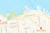
Verdicts & Comments Add Verdict or Comment

2 JavaScript Global Variables

These are the non-standard "global" variables defined on the window object. These can be helpful in identifying possible client-side frameworks and code.

object| 0 object| oncontentvisibilityautostatechange

0 Cookies

Indicators

This is a term in the security industry to describe indicators such as IPs, Domains, Hashes, etc. This does not imply that any of these indicate malicious activity.

alstate.com
basemap.nationalmap.gov
basemaps.arcgis.com
cdn.arcgis.com
conservationgis.alabama.gov
fly.maptiles.arcgis.com
js.arcgis.com
server.arcgisonline.com
services.arcgisonline.com
static.arcgis.com
www.arcgis.com
13.249.190.111
135.148.66.111
18.234.22.28
216.226.185.187
23.73.224.166
2600:9000:20ea:8c00:1f:cc84:d980:93a1
2600:9000:215f:da00:c:744e:72c0:93a1
54.192.51.49
65.8.20.91
004b76d60974df8526f9b83f74bc557c1713db9f2c304ab7bd934f16df7ebcee
00baf7567933913ec884b8f409812b17db2dd8eadbe7cfcdc870da2866dbcd41
017244a98ae4e03c3e98d15d411d53beac8b31df0e8a8efb652b1f0799db7f6b
02f386c4f5214c25e7d2afbf499aacc975e102db417a8e4d2430dda1b9e611a6
03ce9dcadbdc2c11f404183c9912f55eb3ae7066e3001412700b51ceaa0d6f18
055ea2e28107445904d0ccbdb961626a929ccd745ded82cbd6e92a80bd993725
05cd26498b43108e7ac6afb68155d5864b400e7d103423d8f387f7589e043e7d
0602a531082cd399444abe2c6285ab4e583fcc480084034e142bc127622a0b95
064053ecb71947c73ff8034840d1c6c3a3fd851c7c90d500167f21dd3887faaa
0b1395ce3607bc6dc53d0eedc5120b161cb3f3ff5484a94d97a75806cc6a5121
0b17ab9ef08085422c2480940efeaef5aa6328980c1b2125a9bfeac0de355638
0b64baaf135cff03445dbf2067fe8421da96ca147065d175b6660bd4d17b793a
0b787425d24ee1f74b690d5ccfa9257ad59d2d21f595e956e10067989c2d6895
0bfdb1f522aabcc3c03ba0c2cb9404911c1bed912feca6e9a934c4f799dd39f8
0c2696cd1b427b0dc032720260e8e55374abca42269812f6dc38a51c36c4fb8b
0c2f7588992a4d3d5064afba4c40a92938cc69a1e6ca4ce5bf5b2c2aeed76584
0dd1a0d512320d283ca0c99ea78e1424b8ea7a0b255d7298d5e8cd4c83b61076
0e3dc7822814c993a689f3f5944f11f5f352d14c10f7ed3f364136b1296cb5c8
0f55c3005e341f9bf55421156f082863f1048678324b58fab22f0eb459c0d9e3
107e83c352a0b9613febc83b2729fd0a42697f7ccd3b68ece9ee89f4613c1b4d
10ad32a4e2a6d733c6a0fb053ae64cac2af823cad885e3dd4c80628bc8ccb571
11a485b0d9da7da7f4a14dbb53b7d1b88861e6052f5739a29a27d0a146e42d26
1226dc58d0052d7d17444842bec383859d79ac3e5829b6c627d0a4b5b7ae1f33
122a372d7f05dccef8bb738fb1571542ac4b79e3affa68a252ef66e4fc42456c
129de4bc98e0ef78931d38a1a189acc040048915c9a350770e7b6b483f414f2a
133f96ceac619d2317cd9e4e3e9f40f30929fb612c170231cb400953d3546602
135de0d561bad98b42fbc537523a49c66cd92c0a9a7c279d7779e30ec872fcd9
13c319d4a45ba74d5785a6bedeafee61c33f9c5acd2436e5f9fa21ae77a0f663
15214622f74962581cf564d5bea7bf5a7036997984c08ccdf4f8172f05b10854
1543831d417993dae8b7d1a087806a7a282bb7986e09b174ac5bd63eb0371ed5
1655a60acec32fc6fe2002435ad30b760f73078d356937bc93865c28003fc900
16bdb00b7ccf4fb39277bc8f7640aad0860fae1fa9e50b3c45af812a112ce5a0
179b9ea5da88c6442fcbaf600206da95ae407f99d2c08ef098c8de5d0d9b535d
18704f19b500dfc61207e024255191fe541b1049263e76289c76bc01e77c78dc
18ff4ccaef95e74d4e3b5c7e49adbd047252baaff474ad92d01beee8f39f1f7e
1b6b951f839497e98ac1bcc874a2d2761d639a5deb782c202cf26998256a3dd1
1bb092fca8fe29fdd49efd986f7503d686c378ae7c207903a1e1b88cad983872
1c91c490cf60979121c8ce71fbf05c4c0c3d960791bed1f4cfcf1f7b503c07a6
1cddeddaa189a8df33f3387488fd8644e8c2347c5336182dd9eebfb9a5277fca
1d9809935fd4abc704f154906fff2422a60dd823eb036519c6ad045de261a611
1dbc529276a526097603e913806aec7ce4ebdd923e8d128e7e9c7754129a4253
1e24ff272c08236aad7dbe049780a810d9c457faa1ca18a88f2ac782e04a219f
1f930b764c180c0a11b0b91f348945483a9c11491968038d9fe7a206f8dd40bc
1fa53aa371aa71ed34cf96aa9c9b788f18fc99e760ba9f1750893fc083e89ef7
2054946c96db314ad41145750d07ba49e1503619785cd8ff0ab606987c4153e7
21200405feca13e2c621079255f31d0e11b2567c96c80cb7fbe05de4560479ea
213bc46777e76de355026f82fdc3d6978bb17f08d2e3c3906199f315ab5c3301
21804cd3987579e8d99cac374168ba64ce0f3219a2407397ab4ec16d555dacc3
21e22b8cce0932a309e0d3713276d9d190130e84e65d1eb11671dfc148c629cd
220b7f08b005125c43916ae55c167d3b75987c04cebd294e596c9c8c2fee6931
227493806dd4dd553b7ddc71d80a675b077b831b4edc841ff1eb469b5b6f7076
2275b7487b8826ada4c49f7604f20b2ef061448fc2744a3a270c9aad5046b9c4
23326e6a92a6b78e4e8baf651767f273bda191634e6d08b8642e522fdc20dcb9
252978f4b2a892e92a10e65ad746290d4d57588709422f70a74ee8728e25068a
27b1b44a5bbcd810bc297ad5e4919981475714682b3cf7abb7eaa765a311cec0
27c838b3bfe596436f4cb4a4d126c0df59444e448932c01da68f1e3e5883bec1
27e783377e38b5e43130396bb171e8fb9af66d4ad4888da30337be2e2cf6eddb
287dbec3ae0a4dc553b6129b2572548cbf0831a4d42a885e099f73e50aa96ebc
2889a0b41f5fd22ee9640a321f7b40dffd52af422bdebb2e5a6e373c74811340
28c54973ef09f4324669a8d57224a2e5ed32a3361f7ec5a6d94cabe712bd70f8
28ccf2ce7301ad66429c4ad439b868b44eb28809e4fd6f92ea10b4b3dd13d73d
28e688eba19a79a4d015663b147ab8829c2dbbf1c66116b53389251b18f4f0dc
29925b78994c870904b5f031f804d884c514f916b628384b4ce06773ef3915ce
2a0f94cf62d26a584de753ec744831d366eaa16629a27465f9e2f0d12749d56f
2a1e8737e4e8c4aa7c1c37acbde3911d0cd807bab6932e999d828e60d81a1484
2a23a0db71ed9a658284e762d9d98a62536f14474f35229e0a03b8a420db78eb
2ae2644c181fc5cc256b2a794d798018493aa1d3b74fa22379b83246cc74a45d
2b31737ce1c8cebc4c1b0fdc5bfccaada8489041b5b84379cfbc486abca9dde7
2bb157c2ab143484f6527b8ef87efcafba5ac6bde3fa9a7c7496fa207a4b0f5c
2bbc7ac509ffa9851668eeaccd782123e8e74a9391266f7a0a1f3a706506e97d
2c38b46568ee62c4dd4ed7ed433666e28f6e71f3d542bfd850a2ccfd24d0e24d
2c429d2d06a0a78a3d644fbbaed79716c9eccada7d379dd5f5b6b0f36c2d60b1
2c5a2278cc25910dba5d1fe15163be14f30d3c8274147013186ac88448ef5225
2d65f701a66c14ac9e298a2be0d7f6cc0d75fdd59ebb0892a12dad76e1072380
2fad0469b7c0829b4d5445c47c8449c9052ef611704ce7dc476ec3266a08dadf
323f78a599a5f15e96a629dd88ba3d2a97b23b4cd619d9490267e65fe379fefb
333b0310eb5707a6883ec56f051958c49cde66e563a7ae0fda79e3b4d12622f5
334611ad2b5467bee1572e185aa1f497ded3998cb510688a8e47ebed7b8fcb05
3412a9189c80c359bdb358b48f3c6be1193b9116bfc7662e08b37508b3823127
35baf106899cd28c3eecb7279949ce47bb687c044447062fbfd4c569cec9f24a
36a2a12360561ba371c4c5af1db6846244223bb4eabe718b83f070d624ede90c
36af4cbcba91dfd381c7462fa9286df486f0a01bb31641bb5140b06c421c4fe1
36cf347d40e53023dd40fd04bf895796601d32aa6a3bf724639431b6e87edcc5
37a2ab22aae5cbc07925f5f073efba4d099617754f293e73ece470fe7b686c30
37cd3eae37f1a200a83949c10d92f9d4e68b40a323a39d681890ab22650bbfde
38030a1792ce3e437c5ca22dc5a7f6141d66d1c987625489a02f7623cd044adf
382803543fbdcc1ba9810262d1ca29e783a3463de6cdadf67f4ff09c238e36de
3828efa7602db4e654966c9b94f5c59b9765706f57b8cff7e36b7e8c349e6fac
38b470c2fad33cf2a06af74fa5360d72975400547081e7a79beb858b23ea202c
3b110c9a55d7de7315aebc7d717ef510e2a717c5d8fbe26a749e2382f7b858d7
3bf138276c41045767da82f64dcdcd04f3bb71f4fcb5c9f6c573e6ee4a8ca3af
3e1ca3aa1e7f4b81b8c9195dcb2af0532ab02a840954069aa32cc97a8a9db29c
3f70c32c08607b2ef0774dcdd50f41da1d491bfdadb509e7deaf346032bd58c8
3ff2e4a67ea3a28aa00fdd02e51cfc7cc34e26ac55d987c173a9a8ac1e8eaf26
4003a01402eab36ab81d3b21af9b2015a29377adb4b330e1693d44e2929b61cc
4060ae06ceaf6ac15a70ce9180f420e9a89307e807cc80721ad28c522d3bf156
4246d615877eaf25bf105e487a2220d28bd2478738504dcf525fc3b6865cbb4a
42570d6e7e3e020e0971a8f672f23e6fe3b10f305063b60e838c231752834811
42f38f831ecdcb3ff795e6b85fa85155008d70d25426b2b674c0f7d5b73de805
430f1d618d9625d811582297113a3b96a37b76ed9be23dae0214de1b097d8282
441ae85fe813eb440eb4d53d39ae4af1009e92d0bd6d1ed3f798615d55fdbba6
44f02987a866968d816aa8adee45f5bcbf831fc4a52c5fe94b9fb170a987bc0c
45aa00bd571725470b2c673c3b3212853a7a0ef3ed8557a27ffdf459b44c8581
4858a1d1017c1973e107445725872143df46c8b15ae47eedd9525fd1c709fad0
492491d3891e81351e3bb66e4f88939e1a97ae69e23f014bfd0f178775336aec
4981d8857773d04161be189f474aa961aa3b0108c72e3a89243fd61020f57586
4a18f054f49bee28523acbe13959d65bddfb27cdea076946afd54a4bb1ef5f23
4c6d2e25bc6c0d80dea935d974dbb3dcb1c7555fb10d5206effcb78b9b3eec41
4cb41153d6a5b65e983c09dfb55e26a3fbda7d4bebff70f4223a5929d36e1da3
4d7862e360995c7a3d468bdc8ef629855a400b9bbf977c3cf82edfda0f93fc59
4df4d0c5a7907fb4d431781ede79c8377cb0c33f443ce18be5aacb9d2cee06ec
4e587ea96e2c76490a6f87b442a23a1ecdd90c3a11137ea77ac84109e2d3fffa
4f065cf9a7c4bdb0ac325beb0c6f2e8aa7ee66ea127e1bfca3b0a6e95e4ca407
4f4973415700270609d5e90098f7c01c88e3bf08fc0525ba2f96ac9499c1d637
508a2def5a15a1f9125b6ee1e2cd9cc05fc4430ad11875700689442820be3a60
511e291ce13c240a0cf5cd6f9db4dbffacc2c38650e80cc5703faa6eaec0359f
51baed64fb12c23ecfd1087ba4cd65449df047c20430de480c4fbb05a7ee664f
522a4c4d097a9154efa1a05438484e0c0f06cd8f6f9e8427a9ca16e4863127c9
522b6841b203230d8e2f21295710c249331bcc7523c3aa56e3c52513666fdc9f
529c0ad06390f1e403364540b7c9ac3fea1836deaea46185784c9e151059be67
5316ac410b07db9719cc97ee3c139fa092d4f5ae1d7b3a92dfd1993e1e278246
53241f838940928879560e375771656be4b36b655a458eb924bd991b9831e2b6
5333f61b98a311068cc8ea229d5e9631d26f97bae961253311faf93db937f24a
54f0a8d99b604d207c167020c6d82dd394d65ba38360cc1f25932ddefffb8b9a
551448ad1d2ea8d4768a620da9f1754afd626eab889fd1d55a5137bafede30a8
55d237d345d976e90a59d76274c93e49dd29c75539c36b5ca98e98a513f156b1
55f1191bf813ab638e28e21a3046039327ce801ea9af0a92cc776e53d2d9ba4e
568e6db6b23bfee442ba4a7eaefbef187c17d7f4f160381e6f54c1b98eb2882c
57e06d42a9485d53ccf6de9a086a6aa599c3d17721a2cf9ac0acf489abc17731
58a9db271671867fb3a7c5781d9c5b848cfa65c21069f7fe8a50b75c51f1c089
59533a6759ab56c509650643b9eb2171535dca6b9754fe656a635ab252d48f4d
5a36ca7a49ffe4081fb172427355458380a4e80f025f36237da010a4e04f6624
5bd5dccbdf5ac8439ff4c127a80f9837966d6f4cd053c8764a75f0e9daa9f76b
5c0cb6cac43eac846ef9ece5025abb6054d47faf48d63db9395020edbf74b5f2
5e3aa05fe912bef87d88200e3545e4bbfdb314938f66a4c28bbacdc0e2d0f416
60869fc9af75975755253b36f88e9bcb52b80f39a9fcef8f3b37b0a09d759710
60a0bb44dd4f6739c24d47d793d1bb2bafcf06f21be65fd080f958393c84e2ea
60f42746fcf3838c3d8f1e0199e6ece3dd7945e622f36e6feda4b42758938142
60fe774cb72fe7adeecde4b80167594f91b03b1acda482a8352570d19f77294f
61b565fc2e64017feb40915d9fec8204404fa6a42ac60d109abb2a558f54563a
61d08eeb0306093b05a31c6780eb7783141d1fbdfd7e3bc9876567c0a36b2a99
6233a5c57c8d84bd15d5b38875a5d5f09ae33886571968f32c4c9d0c2274f3d4
63519f7e7d41bf1a9554c2ed405d4d06274a78648c2e9a99fc168be4775113ae
6398ab9b40c749d91a14835531546bb995638bae126d592142921ca8297d3c40
6416d5400502554c0074a27a2849765cb8c7e70636e0cf5acc1906767abb8c4c
64eef85ff1f73d8a5180e5a52f8e50b544be4baf7d60a54eeb0d446db3d3007d
6654c917da33fb346afb590363e9042fe5f19c5b5dc68a92a5e0f102d58c6e4f
6716ed27af9478a08aa2ac2b8971962dcb1913f4796dc1dd58f65ce6b629b692
673c6e8a5dbc9c35c6172c4d26ec2d960edbf861733bb27042d76d61ce8910ae
67aae8fadf59f47a2884b0951f8735fe312b7ad374d03e7442d639ee306d28c0
67c6880ac21fe170de1b3521f8ceaa54a67807f06d814b269b0c44b34389be9a
688d4f29b34e1a61dea10b74390dd4c579b3637b26d9fb04de222de92d1ad5fc
68c6a1beb284714fff8c7f01c642d9f3214c853c16abca94eb1d8e9bf666cbc7
68f3ab27fef50386bc2c3a525fcf42508ea3d19748666e9e28a493fedba102b4
690b4861e87e60eb019d68432bbcbd45505d7f2b0cef5fbb4669c91e0a1433c2
69928f1ffe8c3beb3704164d5c2511ec4122e791d55f1f560eb4bac3375704ec
69ac261cdd14537494accf83847f9857e15bd668681f52c35fd740de363e8807
6aedf162bda20c110a7eef08c8f02b00d5fd54a3ced2539178e04c96f5040ecc
6afd78f21300716a6e3e05aefd3f2c612bb41584a6d98fb3903c20a02e5175e1
6c364749b980033dcd428ff62380e5d71e446c8f5fa737577a95bc038869ca94
6d034a76fd86105d1293591ff47885ab6c407c4ef88d51451dde6981630b5e13
6d24815924b1d51577ad37a09c3f0e328a542c9182c5715d985bd0194ad4e0c6
6dfe027e74b645510d7f6e9bb55578e332e2ef9496562735794195cd12682250
6fc87bb154271cb4fd34720a2e137ac0699e447e05e4615ce1187642be7b0f7a
70ce28e2d4fee557e8ca98d512243631433a1bc71bf30f1b202f3cfca1bfe72c
72a562128d1a7a21124af8767331881bb27dc4ab969a550b8e32b4ec5c18ff17
7304936f243ae8dc54e6f84e0c47ace8ab7776614c5f15f6aff76049cc4482a9
7423e35463965d748c52c08c3bb27d2bfc82aeee66fd72601bb97c370abd0c5c
74a854f9ffe260fa0e83fe13cf5694345f1e37557390916acd910c2d4f09df92
77233db4f797029fdeb1b7c09cc11a37e07d95a8e689ed2c393a5ab2775319ad
79e622339bf1c54ba09958d3293cf285eca62be69f266ac4c9a2d56fb1e83dc4
7a5114def9a5184f6905ef3eda6939a1ddfc54a966d88495f5543976556e1731
7a5b5efce5cf0919c7101898e8c8f5514e75ff755b45ca44b1cf0fcbc041f5d8
7a77218019aa6d8610ce3da72b4f7debb0cb2316730f3ad3ccf03304a8e1f0b7
7bf90c36df0b9febabf595876d76fa3cb0e3035d6ee0345fc3263b4d7f82c728
7c37736948bf2ed4ce3b661cafabfccd3a88463a34a69ca2ec16fcde8962d48c
7d1173f30dabc8048664a860f50a4e9904d571aeeccb1edbd118fe5a4e9e5a1c
7d52d5e99d03b68d4d7c6d9bd50d7280d0fd5b508100024655202263d4a8ad46
7d62e129e25f9cf416ca89c91322f64d8c3d4e6ffea24e8dc4f9c72eab7122c6
8074dda0c9d431277cd52e695d06a423cf7bef20d057be58161e59b79d796f3e
81b10737750da08d91c5720d6717436272cadf06788e56395eda637ef2e17824
81fbadf17807ca0d300d196e2149155563e471d7ab940828e874879d8a5153ff
8227a5d8089ad342dd9ce997523dde444cc105e87dd057926daa25746b8b7ff7
835e9e5412f28a8ce60fc43a3588130c6278e595805e67084533cb849058de48
84221f859f8509997bfecb7fa5412e6a23d89d630926fc5ba9626f5c06520af4
84c822074a293492c27c7a2df4966137111433eb6dfb1b06b27e88a813a02e35
8778b49faea036c3554db0862f9017c4c37111a79282218c237bfff0b761a747
878b9197ec98fe6a4732722b2f96e61a538fad33020228cb8a83304626afc27a
8a3f82213b7cb648fb4ebb3ff2ce4e55590967e92189052cebb5a5778ee516d6
8c5029f90166e8151aba6d08c62e3b133800af0ad82ab0abb651bdd50d3b6a67
8c5213c56a639902976c16eeea23085f879d2bde67c96d618f887e34809ccd87
8d645c9b4770026f819a23536a1fbdf00e0181a984865a3812d8e56b7ad74ade
8d8f47a43206af280bfcd6ae55e4e373471ce8e6f838645bbf3d195784e16777
8ea6e17153a25d8ab02482e2ba78ec75eb8b4f8b227ea7d022cbb1eef6698708
8f375be124220245f78597c299f94b99bf7148387bfa079204a77386701f39f2
8fa26fb462187feb8a8f4cf97e2b8a698753ebba257024d7163a99fed8eebb1b
8fd9cc95008d58204a41cef02dc21647b3c8c7450311b93b85ddbaa8b612cb8e
950d8a6502d5a9a15ed5da1f121a6815b8f68e2606f967e8f524c655e57e84cb
95acd125c147f01eed34feb3753412b6908bdc3c27515628c0960da386055715
9750f99c62ba1bd8e2dc7aaf8ca421a69b55f4069d19b5d1603d1029b1986879
9854e9a60995e02c90ce325420406aa6586de70ef0826200f9029c1ba623a672
98a5037c144ac5dbdd97d33c4c948a272be3d1a21f662a375fcb3dc49acea4d1
98cea3c7665990dc92cd163315d0df37fc8d01c7c8967961c77edd9fd5a6cd06
9933c8f3dcc74f105bef71a22cce3f3e36d0c75f1a252e38ee47538730f7e70c
99830390e8980f1db5e8448a569f1173479877c5761e4a18e761decb731e627d
99dcb4a0e81bc35f99799ca81a8e20299ae276ed5902a8c7f9c907d757bb3b0e
9ac550195b53149be2dff42b40feefe3a8c4fb8de0ec453fc573704d8ef26978
9ad99763ff727751c906b78e10f8ae237cc9a0039a1a1a145c4e8bcc1dad1cb5
9aec9af2ac096c414341e6c70e348be535017edab76d093fae3a0de2bf916aa2
9be50f58f00d77d6e566ea913cdf42f0e96d28efde747d85981d058c96bad466
9f9b8ce223999bd3495e81de5dd383c28bf8fddf12ac53229e61b7b3e412bd3e
a0b4ce3a343d1a715bf22a9cc96e33b3b0cfb69168799eb42c00670df8236816
a2ac7f6927ad79bfdb311c81b7e29bd7314443396be2cd939713cd7366e47333
a2fb406b68f41e76aba8f8df257d45e84c76f2a8e5055f992c5d059579a91dee
a334c0f070f1c4a8f7ee2e6c1e9af1567ff143960a2783cbf8a33aa3acaf8cbc
a334d31dd08ebe90861af9d5fc6e4d511bbf6ef2bd3ddff0b60629166bee8c1a
a481ed665bac7d83bf7ccda337db26c600b5a0b3a53a1b19e3158beafda3ecb8
a5bec5c1b3d3cd31eac132364a7a4704d299dcf57d378a6757b1c4a855ec21e7
a76d512ef1266ab99ff1c997dae10885ecacc773bd459b9fed5a44dd04c1c081
a7e5a82963b01899cf0c8d6042b015f1148ddc646eec8adbab8e9c73c93d0e19
a948e8772b647a5fe907c9d734cbddd107b5526f0c7f027756c1b3c7cc9be56f
aa00b322c3596560e3b624244db498f736470ad7044b79882ce3cba9cae713d9
aa6ba62d0202e9ceb2a205f975ccf60ecead4e6b3c138755f49dc4c17c0dd7a8
aafb725f4849d34ae586221e88e3d0d57a099ea7145607e89331a0cead041157
aafff3932f80556a6f169f9ac58ce256fbb474e9bf4d57afac864f6556f0b799
abffb38f6440c2316858226869746237c75263243f609c81d015cf7cce5fdf6a
ac8d1a03de2db4a458b4ecf6a062c48dca5750006c79185afa2e71ff8f158ceb
acd9fd9652ac62699c63baf26f0446b53b24d0b6642d0ccbeb7ec328a6699f31
af27d4b13554e749170fb135cf07fc767921cd4898cf8ea74f3061e0ada211c4
af42b404b1664066416ea4fa1f8bc9614fe3713854143478de84bcadd1c75cdf
afe0dcfca292a0fae8bce08a48c14d3e59c9d82c6052ab6d48a22ecc6c48f277
b09336a30749a3b05ccee8fbcf3ded0291fd0967f789b2bc1c108ae76bc8bb34
b14d0890adddaaebb8ea85edf75be2aa21fcaea4709e3306dc0015926c260492
b162c59731c4a7c0ca6d90f2204807729e585ff294858c6029afd64085dc03f0
b1e8f6bde304b86aac0b130ce6a032918c20bdb0abf02a72cefc84425e79a016
b292ab8ab20b49441b214f196eebf2be5ba518bc5f1bcb83c8e70f5f41dd24e8
b32fe9b2b199af33bf3ef36e5775bd890f78b706111f21bb5a45f674f68a036f
b45d1631d243d87021dd663a750c818e1c1b8ef2e22ed0208516edb121f34263
b48700e858817955ba2654ec97b5e79f50f88f849ab144eb56165a6e55f5fe78
b48e412fa3d31e382ba64c1540ff76f043caca2495e46cf92923f5c521ce5109
b65bc58aaf773c6547722f278f472c44d5b8b3a8e18db4cf7a59706acdd04eff
b70e11f6f750713fe633b6d5ba87f9211f9ac7881b58ccc6d6898ed2fd562a03
b723bfd6a05cad5d182d78bc669edf7ec7e1c63ff5320aef1ae6bb1c0c8215fb
b768b9cfae49e3f6feec1fd0eb8b22cf4a77081a1185777b37104cb5b003aa4f
b7b404d0dcb82758b74c05eeac12e68cc2a9f269ccc1a9e11e10e5f255a293a5
b7e5a5ea59e95dfd074d171323b8d0f6a791d3fdb63a52e9ac3ac53b7dc7b2d3
b7e8779373ea1c5be635cee0493932f11f216d1f02ad96396dfd4dd3c264fcbd
b81cf7d40c2a352e65b7dd5c01d83e9e98e3e7505fe6a31d3ba0a9a7af2626f6
b82e9c50302122884a06c344699b1fee6e38b3b3ffb078a4c8df3cdf022806f5
b8dd2f915948d02a84347abeab446368ba318d5c06df5436d14eb6ad6467b61b
ba0f77fe18da4a23c3c25ec3345f856fb2e474e3f7693be11f945142c9e9f68e
ba6a33930cfb810a0b98d974f6461c3a0324cb04a5e576bd4cb1e97542b90d3c
badbe1582f27e87d6ecc73194d8932900068fcd2939df26ab06791c7494a7540
bb4834212b22b59badfa9b7d20a9734e3aa3e1e29836f18b82744e40e0684463
bbb3b9bbe89d1597319b0ddab60e44fbb32a74c830919ec1175e1b6f2162d64c
bbfbe977452e298388f19da0e818549b27e91b577f4011693b364ff17005200f
bc57d90c403bde73207ec23e9e4337dc2dd3047456907779b0c090df137df63b
bd1bd17902204372b81ba69ed1f3372d5b3889a34b153e1da5c88dd1063b790d
bef6fac494b0d12fa3a5a735ce17e6c7e49d66ce4475361bfd912e8bc95bde39
c00a04582c1b83dc4465ea4b56889631b3e3b2570cc8d9f4b2447c4b60bc171b
c099eb0fff7f3a31296567669dd0c3d0f073b76cd5d174634c62c566343b6aab
c0baeb519db13fcf227248d1c50245b067ff510d51398b2a46e4b5a12f63ad5a
c29ef2aebbf74236a0f406760d32df5a61a66d331fbd643e879be8d9cb439597
c3bf8dc4ec5e5e22051b17a2a6cad05927d9dcb2f4f52fd5a569a86b6d5dcb3b
c4e9505336eb3c5f322b3cccfb0b1bac7cb4acb112d255a73f73bc1746f0bb92
c54b1a7ad15f2b0d67deb0fcfa106cc037ebcfadd0ac10b4aac8ee83b39f6b20
c58d5a3a3624f909119fd88a5dd4cd9553b408bce626b1e698eb3aac6ed818ae
c5a23eeaf0c3163a2458a4fe5f72b3b0c770442bdc68286b9ac1779059685c8d
c5fa028d47d0c4916742097348fac03c23e9ae6f84f9a4dbfe488129ba4dacf2
c652a1aaa177e5bb09a5c6369180c447dba8aa58e67987d73c78878dc5651f7f
c6bf9f25de0798b7982e68e2a07349563ef192722de510d940f43dbcb1727845
ca083006b0ea04ddab8d6c53a1b8db5ad6d4fc6d71bf5f2f02c68a3cc0c4784d
ca3acb8c9ef8539aa23795d81691bced6943ba9e4b1cf7a1c8fe6178c77ac4e3
cca7832ee867d4dd0f552d45296a21e3e19002d50242b0121a7944a4f9b7e52a
cdef408779beaa5805e7046508b6b841673b3309dfc26cacda899fc1fac94147
ce1bbb2c3f824c010f7be60c2d70fec98635316d33d8d77d72f192275a2b3777
cfbfb2bda97f804bb4fd32c854fb7ac609b525394c64b5bbf4cfb73f58b75731
cffad811bcdd55ae9fd24c4757c155125bc76405a74f697b1acbc8e09ee53f81
d0130a4e0f85cfe5cc68d897094e78ccb0494b6e2b3ffc308209235bb9ab7c85
d19701e0bc67ed336944bf50de156b3cfa33f561628950a8ccb1ad18cd124eb0
d199b6f152b04f949acb2653e3525e7661320d095da3ebbd8d98c668da3a8970
d1a0049af5bf45e608f384d3c448e46a4aba94e05c56a06162d09f35d8417618
d1d7adaf044eb380fef6621aa3ba722d1f6e9e536d1f8c294c3f7343ffef0a2c
d3112b11c7163c65e7213ee77b5e809055a7bb52ddad6cfd2a19e321b6664e69
d3669e3e1799210bb0b8da924139d578009a71e9b8357b9d688d3f87fc3c8c56
d4262da114584305e62057860cc385d61b3a320343c0cb7d62c2e4e445ad2c3b
d494ecb9f9018920e896ad67f26fa5337f2f7c0df8e921f56e55e353dc547804
d49aaf1a49996f38b9eea96ccc207ac84e72fc8e204c372b9e81ec0ef9f7c1ec
d550195f7f635d5e8ec2f867b5ea9f674cc80b7cdf4189d2ae6c15acd0926660
d55c4896f0e4a6945eedcdd15275d0d19db07ad12ac5b87d65a620b082a66e56
d586c961368c93e692ec9f607a1bb0c57b2b009613b73edde18ddd40e677c94d
d5b039a0e2a9597f08f4ac224b6dee5265017c65be75377b9686eed6660ea1e7
d61a9dd0368f530ef2a20377fdf773b33f09846866ee71f38c174fce43eeeb9f
d6d985095a8ee1c7502fdf6acb9faba07b23e1969435da4caac1bdd24fe6a513
d728e8e673a09fb459f0a1032090eed4278b270d3b2971b8e4138551e9dc4c8b
d835ee8164dfc41892826308ad2feaf3970e915d6ecefd08bac4f75aea8b852d
d875bbc68e807a36e5313e1d20a99fe0f9c7a8e76fa644c5565665b7458c2d01
d92d03bd87cd03eccbcfef136c2c88794f3a36c2187d47dfb2024495c0ad8cba
d957df36d891781485936004d0e2626b15031e0cdcf56ea3a3a8bb47820cacac
da3fe40f14416f238c2faff2f17dc8f40f9583d5fa32b7404859a45f877f7e2c
db54cfb5b8c83e1414dcda553845cf729ea15434e9a08ce94e9177b44fde59a8
dc256070c4f5934c011fd4051c9e89d7250c5df66a7ca74cb270d224efb202fa
dd9801de2ea9a7424c677c3c67135bd5d60c7dd523a5745ae47812fd4c07ac71
de3c2a4d1b161926fdb5d29e8b11c498da9279e9d5525f7179234eaf2a061815
de5e89377f0d11c1bb80b91f681d823dbe1fb788e45cbc29db1c09e7de9f93e1
de846c79efce98e25cd95c1c089d4b0aabffba888d80202593ef2604f59e7242
dfc74f47215341f6c5d22cfd98429e9a033709aa37fdd7e6c1fc62bdbe6b6901
e1e97f59f67ff5d01ffd59240860a66f12fcadbbfecfb5d20d9312a1ef6e0265
e262acab4630c3f88f10ca717ac884b938150cd2b082ad1eaed5ce1d5d81957d
e2a97d5f5c8d62c9b46856cd711fc517e471894922075c23cae24ae00f2d1819
e3540c65a0ecbb8d9c3ab1d63da45780926bd3b4bf0661191bbe1eaf0aa063c1
e436c117a914ebbeb07f14dc6eef39b13f69279444f231b6883c9358f1dc7964
e49105fc0e7d2656fc7b4b7bc8601c5a5f02c014b311a1483b2d952ed331391b
e542bfd83d173e9f464e768b6a6dc364df382d3dbb3863601733568007c0f945
e545bc462502997c56fd0e7bac4822dd787556f372f3c98076ab46b135e4918b
e5565f5eba80768af0029b2db1637b4027dd2baf2e801023a4b13fe84a174f05
e5b8f5970da8a25dd26fa3717e998d34c4a04678ca142b481f9e1bce43186c84
e5d3f408a462a67a2ecb23f9ad405c2f834b4c469097aea882aa64a447c5d838
e6f731c767128a750bda0e5db1e01c73c7157939504f014c80ea467b412ad54c
e6f9eb1768e84e96140a459769d8c9b485bef7fea50afa0ae203327dc26e95a3
e7895c5f9dfd14d9bdf27c849b92031973ece9d75bc06b2253e0943a2b4ba4ac
e828589802ced3e2f3bba65d8fb196e6a99db03141bd573b14de03c3019f03ec
e836afa2524aee0e6347b84e1eb7942b6cbcd4d7853f188088af965cae4a7480
e841a25245b09d8f429eaa10a0171f99b7eda7255f52c21736d9c1898a16760f
e8970aafa54f7329d544563fee2af0656c17cce454f8bc854229dfc0c6b6fe6c
e950aab40f07a77d531de7eb871028d3fc54e91ed0fdecde0eee8617978abee1
e9d4baa109f91d460dee164b63673f57b390530fce8afea6206abb9574f6750c
eb71717322684d4f482bb1c5e6341824c35293173e58661b3183a2b0e9576fac
ebd25c844beb1768f3d9ff1eb8a65ce1393b4ca28e6744423fe74cc73689a86e
ecfdc84d1b5016c2818f141442b0b4b36150e453b2da4ee1056e0e9501b85a61
ee7682de23ce3e719b978beeb6180a3d37026efc7efe040d89b0e2ff3b5946ce
efe93b6f20c86e2064291e5a13a4d90b85587effeb8ed45c793f103725c987dc
effc9b3f7af6141e8cdfa6cb22a3363eb68bbc35e83d2faa6c8ddc87fc570b20
f03e619ca6dd4811f2ba5cd682ebc68f8bc55ad4005cd26fd30b01eb1f38fcc8
f0cda5c3ad2097d5183f664d3289e731dcdcfb6a0b49ab1f7cdae5c1769edaf9
f0d7dce5e05eaca2e848dfe7b669418927dfa8d1ab544c00014d51d609cc3bf8
f22197c6961d107cf373f3bb29e78f0b0abd76d4f6b87c4e52223ee77b6672ba
f48f31f92ef1c3fc812383424e82199621d72385cc0cba39a26425251d693748
f5b7635f00b3286e82eb724038252b3d877859e00eb3d1308d2c321e31dfa61e
f63d364d3ca8a5de0051bcd2d207b27855a8e04b994124d46b72a68c5ceea0ce
f661fe266fa1179b0ce921b09ff03516b06aa1d44c30fd7916529619e9940e26
f6b6cc04df26c29bfbf210f428a94fe0b234348be207abfd1e69d3bee7089e12
f7cbbe217c9ebac64672547b935cabc35b77e07adbb18f6762c699ccaf56e507
f85edc60b42575dedb46230e763af60c697a9420065392bf81832797980ffe6d
f8c0a171996f03b921862fefed800e44eafd138c508a5bb64217d334c514f943
f9900662786f8ba2c16353b12bb190287a8f2ecc47ba13af2248d09265459202
f9e2c56a8155ada4c9e4b9bf2eb33a1d53ec5947d07f04576d0815e50dd828ff
fa11d712afd237a5cf8ef49f43f52c1f05f5a72844422e7486af2969d2ab3651
fa9c23efdbdba5120cf29cf12e44d3bdaa6dbb533e21a61977c095e4a2edf76b
faa7a2b904edaa7e53079bcbc06b97a8ed26e99938ae911431ddc465f4869a24
fb22734d7e00cf83e31713a02121962854c4e9cb2a7d80bf68929acd7f599699
fb49f235f213e1c954599177486dbdc04c51a6a1845c9c6828162dfc03d7347f
fbe2a7aba275f60ea146a7e8505ac0bee6e6ed51d1e6a9e7bd69c3dcec53922d
fbf035f8a2583f5c410ad1cfde2a45b7908d173c8774987c4e98cfd43468c225
fd4bb2d0ea25ee1a7a719c98aae1fb837f612eabad068ae860b895d77be60e46
fedd987fd1275451e935a7c917ce70b667572febec2d61071a6546670d604d9d